
The construction industry stands at a digital crossroads in 2026, where traditional surveying methods meet cutting-edge technology. BIM Integration for Land Surveyors: Seamless Collaboration in Construction Projects has emerged as the cornerstone of modern development, transforming how professionals capture, share, and utilize geospatial data. Land surveyors who master this integration don't just measure sites—they create the digital foundation that prevents costly conflicts, accelerates timelines, and ensures every stakeholder works from the same accurate information.
The stakes have never been higher. With construction projects growing more complex and budgets tighter, the surveyor's role has evolved from data collector to digital collaborator. Those who embed their geospatial expertise into Building Information Modeling (BIM) workflows unlock unprecedented efficiency gains, while those who resist risk becoming obsolete in an industry racing toward complete digital transformation.
Key Takeaways
- 🎯 Surveyors provide the essential geospatial foundation that anchors all BIM models, making accurate site data the first critical step in digital construction workflows
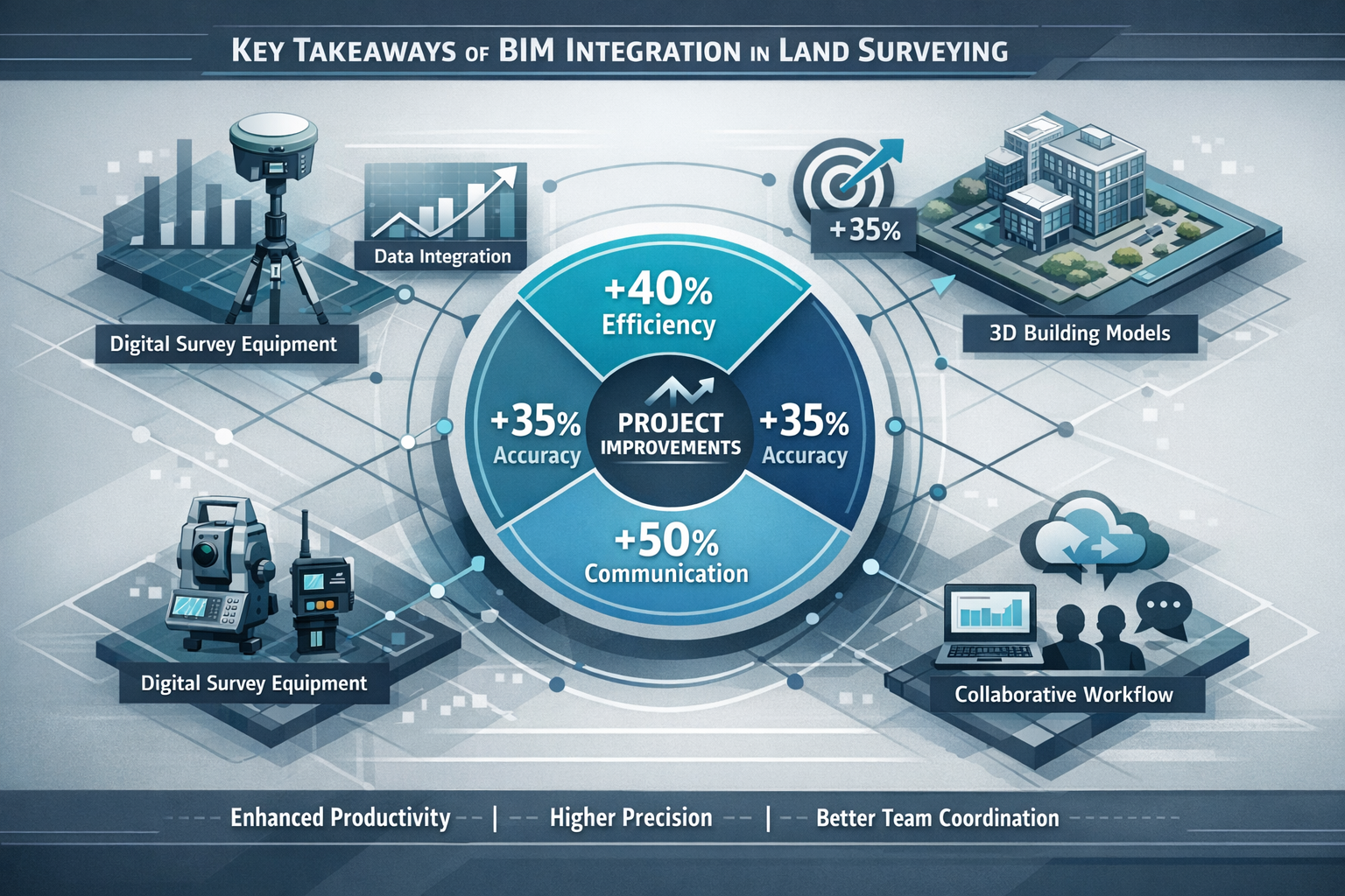
- 💰 Projects integrating BIM with surveying expertise achieve 10% cost and time savings while improving overall quality and reducing conflicts through early clash detection
- 🔄 Continuous surveying throughout the construction lifecycle ensures BIM models remain accurate and responsive to unforeseen site changes, not just initial planning snapshots
- 🚀 Advanced 4D and 5D BIM systems incorporate time scheduling and cost data, enabling surveyors to contribute to dynamic project simulations and enhanced cost control
- 📈 Growing demand for BIM-skilled surveyors creates career opportunities as the construction industry completes its transition to fully digital collaborative workflows
Understanding BIM Integration for Land Surveyors: The Foundation of Digital Construction
What Is BIM Integration and Why Surveyors Matter
Building Information Modeling represents far more than three-dimensional drawings. It's a comprehensive digital ecosystem where every project participant contributes specialized data to create a living, breathing representation of a construction project. Land surveyors function as the essential first link in BIM processes, providing the accurate geospatial data that forms both the virtual and physical foundations of construction projects.[3]
When surveyors integrate their work into BIM platforms, they create a georeferenced digital twin of the existing site conditions. This digital representation includes:
- Topographic features (elevation changes, natural contours, drainage patterns)
- Existing structures and infrastructure
- Underground utilities and services
- Property boundaries and legal constraints
- Geospatial coordinates that anchor the entire model to real-world locations
This foundational data feeds into collaborative digital environments where architects design structures, engineers calculate loads and systems, and construction professionals plan execution sequences.[1] Without accurate surveying data properly integrated into the BIM model, every subsequent decision rests on shaky ground.
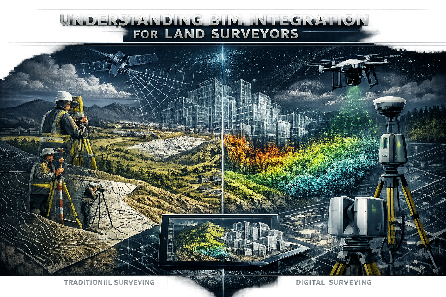
The Evolution from Traditional to Digital Surveying Workflows
Traditional surveying workflows created information silos. A surveyor would collect field measurements, process them into CAD drawings or paper maps, and hand off static documents to the next team member. This linear process introduced multiple opportunities for:
- ❌ Data translation errors when converting between formats
- ❌ Version control problems with outdated information circulating
- ❌ Communication gaps between disciplines
- ❌ Delayed conflict discovery until construction begins
Modern BIM integration transforms this linear workflow into a collaborative network. Surveyors now upload data directly into cloud-based BIM platforms where it becomes immediately accessible to all stakeholders. Changes update in real-time, and the model serves as a single source of truth throughout the project lifecycle.
For professionals seeking to understand how different types of surveyors contribute to construction projects, this integration represents the future standard for all surveying disciplines.
The Surveyor's Role in BIM-Enabled Construction Projects
Initial Site Assessment and Data Capture
The BIM journey begins long before the first shovel breaks ground. Land surveyors conduct comprehensive site assessments that capture every detail necessary for informed design decisions. In 2026, this process increasingly relies on advanced measurement technologies that expedite data capture while maintaining professional accuracy standards.
LiDAR (Light Detection and Ranging) technology has revolutionized how surveyors collect topographic information. These systems emit millions of laser pulses per second, creating detailed three-dimensional point clouds that capture:
- Complex terrain features with centimeter-level accuracy
- Existing building facades and structural details
- Vegetation canopy and ground surface simultaneously
- Hard-to-access areas without physical contact
New tools like LiDAR are expediting measurement capture and streamlining the surveying process, though professional expertise remains essential and cannot be fully replaced by technology alone.[3] The surveyor's knowledge determines where to survey, how to interpret anomalies, and which data points matter most for the specific project requirements.
Embedding Geospatial Data into BIM Models
Once collected, raw survey data must be transformed into BIM-compatible formats. This process requires technical proficiency with:
Data Processing Software that converts point clouds and measurements into structured datasets
BIM Authoring Tools like Autodesk Revit, Bentley MicroStation, or ArchiCAD
Georeferencing Protocols that establish coordinate systems linking the model to real-world locations
Quality Control Procedures ensuring accuracy meets project specifications
The surveyor's responsibility extends beyond simple data upload. Effective integration requires understanding how architects and engineers will use the information. For example:
- Topographic surfaces need appropriate detail levels—too sparse misses critical features, too dense overwhelms the model
- Utility locations require accuracy verification through multiple methods
- Property boundaries must include legal descriptions and survey monuments
- Existing structures need classification by material and condition
This thoughtful integration prevents the "garbage in, garbage out" problem that plagues poorly executed BIM projects. As detailed in our complete guide to construction surveys, proper methodology at the surveying stage determines success throughout the project.
Continuous Surveying Throughout the Project Lifecycle
A common misconception treats surveying as a one-time initial activity. In reality, surveyor involvement extends beyond initial site planning to include regular surveys during construction to ensure processes remain on track and can respond to unforeseen site changes.[3]
Construction monitoring surveys serve multiple critical functions:
📍 Progress Verification – Confirming that constructed elements match design specifications and BIM model positions
📍 Quality Control – Identifying deviations before they compound into major problems
📍 As-Built Documentation – Capturing actual installed conditions for facility management
📍 Change Management – Updating BIM models when field conditions necessitate design modifications
These ongoing surveys integrate back into BIM models, creating increasingly accurate project representations that reflect reality rather than just design intent. This continuous feedback loop enables project teams to make informed decisions based on current conditions rather than outdated assumptions.
Advanced BIM Technologies Transforming Surveyor Collaboration
4D and 5D BIM: Adding Time and Cost Dimensions
Traditional 3D BIM models represent spatial relationships, but modern construction requires understanding how projects evolve over time and budget. 4D and 5D BIM systems are in active use, with 4D introducing time factors for dynamic process simulation and 5D incorporating cost information with schedules.[2]
4D BIM (3D + Time) links every model element to construction schedule activities. Surveyors contribute to this dimension by:
- Establishing baseline conditions with time-stamped surveys
- Monitoring construction progress against planned sequences
- Documenting delays or accelerations with georeferenced evidence
- Validating that site logistics plans match actual conditions
This temporal dimension enables project teams to visualize construction sequences before they occur, identifying potential conflicts between trades, equipment access issues, and staging area requirements.
5D BIM (4D + Cost) adds financial data to the time-enhanced model. The 5D tools specifically assist quantity surveyors in obtaining accurate material quantities and enhancing cost control.[2] Land surveyors support this dimension through:
| Surveyor Contribution | 5D BIM Impact |
|---|---|
| Accurate earthwork volumes | Precise excavation and fill cost estimates |
| Existing condition documentation | Realistic demolition and modification budgets |
| Site access constraints | Accurate equipment and logistics costs |
| Progress monitoring | Real-time cost tracking against actual completion |
The integration of surveying data into these advanced BIM dimensions creates a comprehensive project simulation where stakeholders can test scenarios, optimize sequences, and predict outcomes before committing resources.
AI-Powered Clash Detection and Conflict Resolution
One of BIM integration's most valuable benefits comes from automated clash detection. AI algorithms analyze 3D models to identify design clashes or conflicts in advance, minimizing delays and enabling high-quality project delivery through proactive problem resolution.[2]
Surveyor-provided data plays a crucial role in several clash detection categories:
Hard Clashes – Physical conflicts where objects occupy the same space
- Survey data reveals existing utilities conflicting with proposed foundations
- Topographic models show drainage conflicts with planned structures
- As-built surveys identify construction deviations creating clashes
Soft Clashes – Clearance violations where required spacing doesn't exist
- Survey benchmarks ensure adequate clearances for equipment access
- Existing structure surveys verify maintenance space requirements
- Site boundary surveys confirm setback compliance
4D Clashes – Temporal conflicts in construction sequences
- Survey-verified site conditions validate construction phasing plans
- Progress monitoring identifies sequence deviations creating conflicts
The proactive identification of these conflicts before construction rather than during field work generates substantial savings. Projects that discover conflicts during construction face:
- Work stoppages while solutions are designed
- Rework costs for already-installed systems
- Schedule delays cascading through dependent activities
- Relationship strain between contractors and designers
By contrast, BIM-integrated surveying enables clash resolution during the design phase when changes cost far less and impact schedules minimally.
Virtual and Augmented Reality for Safety and Planning
BIM allows construction teams to visualize every project stage before implementation, identify high-risk activities, and determine the safest construction sequences.[2] When combined with surveyor-provided accurate site models, Virtual Reality (VR) and Augmented Reality (AR) platforms within BIM systems enable workers to acclimate to site conditions before entering risky areas.
Virtual Reality Applications:
🥽 Pre-construction site walkthroughs using surveyed terrain models
🥽 Safety training in simulated environments matching actual conditions
🥽 Design review meetings where stakeholders experience spaces at full scale
🥽 Constructability reviews identifying access and sequencing challenges
Augmented Reality Applications:
📱 On-site model overlay showing design intent superimposed on actual conditions
📱 Underground utility visualization displaying surveyed pipe locations before excavation
📱 Quality control verification comparing as-built conditions to BIM models
📱 Installation guidance projecting element positions for accurate placement
These immersive technologies transform abstract survey data and BIM models into experiential understanding. A construction worker can "see" underground utilities before digging, an inspector can compare installed work to design specifications instantly, and safety managers can identify hazards before workers encounter them.
Practical Implementation: BIM Integration Strategies for Surveyors
Selecting the Right Tools and Software
Successful BIM integration requires surveyors to expand their technology toolkit beyond traditional total stations and GPS receivers. The modern surveyor's software ecosystem typically includes:
Data Capture Tools:
- LiDAR scanners (terrestrial and mobile)
- Photogrammetry systems and drones
- High-precision GNSS receivers
- Robotic total stations with automated tracking
Processing Software:
- Point cloud processing (CloudCompare, ReCap, Cyclone)
- Survey data management (Trimble Business Center, Leica Infinity)
- CAD platforms (AutoCAD Civil 3D, MicroStation)
BIM Integration Platforms:
- Autodesk Revit and BIM 360
- Bentley OpenBuildings and ProjectWise
- Graphisoft ArchiCAD
- Tekla Structures for steel construction
Collaboration Tools:
- Cloud-based common data environments (CDE)
- Version control systems
- Mobile field applications
- Web-based model viewers
The specific combination depends on project requirements, client preferences, and team capabilities. However, interoperability remains paramount. Varying data standards and interoperability issues remain primary challenges, with enhanced interoperability and IoT integration identified as future directions for construction schedule and cost management.[2]
Surveyors should prioritize tools that support open standards like:
- IFC (Industry Foundation Classes) for model exchange
- LandXML for civil engineering and survey data
- BCF (BIM Collaboration Format) for issue tracking
- COBie (Construction Operations Building Information Exchange) for facility management handover
Establishing Collaborative Workflows
Technology alone doesn't create collaboration—structured workflows do. Land surveyors are increasingly collaborating with architects, engineers, and construction professionals to integrate geospatial data into BIM models, enhancing project planning, reducing conflicts, and improving construction efficiency.[1]
Effective collaborative workflows include:
1. Pre-Project Coordination Meetings
- Establish data requirements and accuracy standards
- Define coordinate systems and reference points
- Agree on file formats and exchange protocols
- Clarify responsibilities and deliverable schedules
2. Common Data Environment (CDE) Setup
- Centralized cloud platform for all project information
- Structured folder organization by discipline and phase
- Version control preventing outdated information use
- Access permissions ensuring appropriate data security
3. Regular Model Coordination Sessions
- Weekly or bi-weekly reviews of integrated models
- Clash detection runs with documented resolutions
- Progress updates from all disciplines
- Issue tracking with assigned responsibilities
4. Quality Assurance Checkpoints
- Survey data validation before model integration
- Peer review of critical measurements
- Third-party verification for high-risk elements
- Documentation of accuracy achieved versus required
These structured approaches ensure that surveying data doesn't just enter the BIM environment but actively contributes to project success. The collaborative framework transforms surveyors from isolated data providers into integral team members whose expertise influences decisions across all project phases.
Training and Skill Development for 2026 and Beyond
The construction industry's digital transformation creates both challenges and opportunities for surveying professionals. There is increasing demand for land surveyors skilled in BIM integration as construction continues its transition to digital workflows.[1]
Essential competencies for BIM-integrated surveyors include:
Technical Skills:
- ✅ BIM software proficiency (Revit, Civil 3D, etc.)
- ✅ Point cloud processing and management
- ✅ Coordinate system transformation and georeferencing
- ✅ Data quality control and validation methods
- ✅ Mobile technology and field-to-office workflows
Collaborative Skills:
- ✅ Cross-disciplinary communication
- ✅ BIM execution plan development
- ✅ Clash detection and resolution processes
- ✅ Project coordination meeting facilitation
- ✅ Issue documentation and tracking
Strategic Skills:
- ✅ Understanding architectural and engineering workflows
- ✅ Construction sequencing and logistics
- ✅ Risk identification and mitigation
- ✅ Value engineering principles
- ✅ Facility management and operations considerations
Professional development resources include:
- Industry certifications (Autodesk Certified Professional, Bentley Certification)
- Professional organization training (RICS, NSPS, ASCE)
- University continuing education programs
- Vendor-specific training courses
- Peer learning through BIM user groups
Surveyors who invest in these competencies position themselves for career advancement in an industry that increasingly values digital integration expertise. Understanding what surveyors do in modern construction contexts requires recognizing this expanded skill set.
Real-World Benefits: BIM Integration for Land Surveyors in Action
Quantifiable Project Improvements
The business case for BIM integration extends beyond theoretical benefits to measurable project outcomes. Research demonstrates that a 10 percent cost and time saving was achieved on projects integrating BIM with Value Engineering (VE), with improved general quality and performance throughout construction phases.[2]
Cost Savings Sources:
💰 Reduced rework from early conflict detection
💰 Optimized material quantities from accurate surveys
💰 Fewer change orders due to comprehensive site understanding
💰 Decreased coordination time through centralized information
💰 Lower insurance costs from improved safety records
Time Savings Sources:
⏱️ Accelerated design reviews with comprehensive site data
⏱️ Faster permitting from complete documentation
⏱️ Reduced construction delays through clash prevention
⏱️ Streamlined inspections with as-built verification
⏱️ Quicker facility handover with integrated documentation
Quality Improvements:
⭐ Higher accuracy in constructed element placement
⭐ Better alignment between design intent and built reality
⭐ Comprehensive documentation for future maintenance
⭐ Enhanced stakeholder satisfaction through transparency
⭐ Reduced defects from improved coordination
These benefits compound throughout the project lifecycle. Early-stage savings from accurate surveying prevent cascading problems that would cost exponentially more to resolve during construction or operations.
Enhanced Safety Through Proactive Planning
Construction remains one of the most hazardous industries, with site conditions contributing to many accidents. BIM integration with accurate surveying data significantly improves safety outcomes by enabling comprehensive hazard identification before workers enter risky areas.
Virtual reality and augmented reality platforms within BIM systems enable workers to acclimate to site conditions before entering risky areas.[2] Specific safety improvements include:
Pre-Construction Hazard Identification:
- Survey data reveals unstable slopes and excavation risks
- Existing utility locations prevent strike incidents
- Site access analysis identifies vehicle-pedestrian conflicts
- Temporary works planning ensures adequate support
Construction Phase Safety:
- AR overlay shows underground hazards during excavation
- Progress monitoring verifies fall protection installation
- 4D simulation identifies high-risk activity overlaps
- Real-time model updates reflect changing site conditions
Emergency Preparedness:
- Accurate site models support emergency response planning
- Evacuation route verification against actual conditions
- Emergency access validation for fire and medical vehicles
- Hazardous material location documentation
The ability to visualize and simulate construction activities before execution allows safety managers to identify risks, develop mitigation strategies, and train workers in controlled environments. This proactive approach prevents accidents rather than merely responding to them.
Infrastructure and Civil Engineering Applications
While building construction receives significant attention, GIS and BIM integration is transforming civil engineering through infrastructure digital twin applications, representing emerging convergence of geospatial and building information systems.[8]
Land surveyors play particularly critical roles in infrastructure projects where:
Linear Assets (roads, railways, pipelines, utilities) require:
- Extensive corridor surveys over long distances
- Integration with existing infrastructure networks
- Right-of-way and easement documentation
- Environmental constraint mapping
Site Development Projects demand:
- Comprehensive topographic modeling
- Earthwork volume calculations
- Drainage and grading design support
- Utility coordination across multiple providers
Bridge and Tunnel Projects need:
- High-precision control networks
- Geotechnical investigation support
- Construction monitoring for deformation
- As-built documentation for maintenance
The integration of surveying data with GIS (Geographic Information Systems) and BIM creates infrastructure digital twins—comprehensive digital representations that support design, construction, and decades of operational management. These digital twins enable asset owners to:
- Optimize maintenance scheduling based on condition monitoring
- Plan rehabilitation projects with complete existing condition data
- Assess climate resilience and adaptation requirements
- Support regulatory compliance and reporting
For surveyors working on diverse project types, understanding how different types of surveys contribute to BIM workflows ensures appropriate methodology selection.
Overcoming Challenges in BIM Integration for Land Surveyors
Addressing Data Interoperability Issues
Despite significant progress, varying data standards and interoperability issues remain primary challenges in BIM integration.[2] Surveyors frequently encounter situations where:
- Survey software exports don't import cleanly into BIM platforms
- Coordinate system transformations introduce errors
- Point cloud file sizes overwhelm collaboration platforms
- Different disciplines use incompatible software versions
- Legacy project data exists in outdated formats
Practical solutions include:
Standardization Strategies:
- Adopt industry-standard formats (IFC, LandXML, E57 for point clouds)
- Establish project-specific BIM execution plans defining protocols
- Use middleware translation tools when direct exchange fails
- Maintain detailed metadata documenting transformations
Quality Control Procedures:
- Verify data integrity after every format conversion
- Implement checksum validation for large file transfers
- Conduct test imports before delivering final datasets
- Document any limitations or assumptions in deliverables
Collaboration Approaches:
- Engage with software vendors to improve interoperability
- Participate in industry standards development
- Share lessons learned with professional communities
- Maintain flexibility with multiple export options
The interoperability challenge requires both technical solutions and collaborative mindsets. Surveyors who proactively address compatibility issues before they disrupt workflows provide significant value to project teams.
Managing Technology Costs and ROI
Advanced surveying equipment and BIM software represent substantial investments, particularly for smaller firms. The business case for technology adoption must balance:
Initial Costs:
- Hardware (LiDAR scanners, drones, high-precision GNSS)
- Software licenses (BIM platforms, processing tools, collaboration systems)
- Training and skill development
- Process development and workflow optimization
Ongoing Costs:
- Software subscriptions and maintenance
- Hardware calibration and replacement
- Continued training as software evolves
- Data storage and cloud services
Return on Investment:
- Competitive advantage in winning projects
- Increased efficiency reducing labor costs
- Higher accuracy reducing liability exposure
- Expanded service offerings to existing clients
- Improved client retention through superior deliverables
Many surveying firms adopt phased implementation strategies that spread costs while building capabilities:
Phase 1: Basic BIM compatibility
- Export survey data in BIM-compatible formats
- Participate in project coordination meetings
- Understand client BIM requirements
Phase 2: Active BIM participation
- Process point clouds for direct BIM integration
- Contribute to clash detection and resolution
- Provide as-built verification services
Phase 3: Advanced BIM leadership
- Lead coordination of geospatial aspects
- Provide 4D/5D modeling support
- Offer VR/AR visualization services
This graduated approach allows firms to demonstrate value at each stage, using revenue from enhanced services to fund subsequent technology investments.
Building Client Awareness and Demand
Not all construction clients understand the value of BIM-integrated surveying. Traditional procurement approaches often treat surveying as a commodity service, selecting providers based primarily on price rather than capability.
Strategies for building client awareness:
Education and Demonstration:
- Case studies showing cost and time savings
- Sample deliverables demonstrating BIM integration
- Pilot projects offering enhanced services at competitive rates
- Presentations at industry events and client meetings
Value Proposition Communication:
- Quantify benefits in client-relevant terms (budget, schedule, risk)
- Emphasize problem prevention versus problem solving
- Highlight competitive advantages for client's projects
- Provide testimonials from satisfied clients
Collaborative Positioning:
- Position as project partner rather than vendor
- Engage early in project planning phases
- Contribute to design discussions with site expertise
- Support value engineering and optimization efforts
As more clients experience the benefits of BIM-integrated surveying, demand naturally increases. Early adopters gain competitive advantages that compound over time as the industry standard shifts toward comprehensive digital integration.
Future Trends: The Evolution of BIM Integration for Land Surveyors

Artificial Intelligence and Machine Learning
AI algorithms already analyze 3D models to identify design clashes, but future applications will extend far beyond conflict detection. Machine learning systems will:
Automate Data Processing:
- Classify point cloud features (ground, vegetation, structures)
- Extract building facades and architectural details
- Identify survey monuments and control points
- Detect changes between survey epochs
Enhance Quality Control:
- Flag anomalous measurements requiring verification
- Predict areas likely to contain errors
- Suggest optimal survey point placement
- Validate data completeness against project requirements
Support Decision Making:
- Recommend construction sequences based on site conditions
- Predict project risks from historical patterns
- Optimize earthwork balance for cost efficiency
- Forecast maintenance requirements for infrastructure
The surveyor's role won't disappear but will evolve toward higher-value judgment and interpretation while AI handles routine processing and analysis.
Internet of Things (IoT) and Real-Time Monitoring
Enhanced interoperability and IoT integration are identified as future directions for construction schedule and cost management.[2] For surveyors, IoT integration means:
Automated Monitoring Systems:
- Permanent survey monuments with GNSS receivers tracking movement
- Tilt sensors on structures monitoring deformation
- Settlement plates providing continuous subsidence data
- Environmental sensors correlating conditions with observations
Real-Time BIM Updates:
- Sensor data automatically updating digital twin models
- Alert systems flagging deviations from design tolerances
- Predictive analytics identifying developing problems
- Historical data supporting forensic investigations
Construction Automation:
- Machine control systems using survey data for autonomous operation
- Robotic construction guided by BIM models
- Quality verification through automated scanning
- Progress tracking without manual surveying
This convergence of surveying, BIM, and IoT creates continuously updated digital representations that reflect current conditions rather than periodic snapshots.
Sustainable Construction and Climate Resilience
As construction addresses climate change and sustainability goals, surveying contributions to BIM models increasingly support:
Environmental Impact Assessment:
- Baseline condition documentation for environmental monitoring
- Habitat mapping and protection verification
- Erosion and sediment control validation
- Carbon footprint calculation from earthwork volumes
Climate Adaptation Planning:
- Flood risk modeling with accurate topography
- Sea level rise impact assessment
- Drainage system capacity verification
- Green infrastructure integration
Sustainable Design Support:
- Solar exposure analysis from site models
- Wind pattern simulation for natural ventilation
- Thermal mass optimization using existing conditions
- Material reuse opportunities from existing structure surveys
The surveyor's accurate representation of existing conditions enables designers to optimize projects for environmental performance, not just functional and aesthetic goals.
Expanding Professional Opportunities
The convergence of surveying, BIM, and emerging technologies creates new career paths and specializations:
BIM Coordination Specialists who lead multi-disciplinary model integration
Digital Twin Managers maintaining infrastructure asset models
Reality Capture Specialists focusing on advanced scanning technologies
Geospatial BIM Consultants advising on integration strategies
Construction Technology Advisors helping firms adopt digital workflows
A 2026 contractor survey involving 1,800 participants examined adoption strategies for AI, labor shortage solutions, and data utilization in construction,[5] indicating widespread industry interest in these evolving capabilities.
Surveyors who position themselves at the intersection of geospatial expertise and digital collaboration will find expanding opportunities as the construction industry completes its digital transformation.
Conclusion: Embracing BIM Integration for Competitive Advantage
BIM Integration for Land Surveyors: Seamless Collaboration in Construction Projects represents far more than a technological trend—it's a fundamental transformation in how the construction industry operates. Surveyors who embrace this integration don't just survive the digital transition; they thrive as essential contributors whose expertise influences every project phase from initial planning through decades of facility operations.
The benefits are clear and quantifiable: 10% cost and time savings, improved quality, enhanced safety, and reduced conflicts. The technologies are mature and accessible, with tools available for firms of all sizes. The demand is growing as clients recognize the value of comprehensive digital integration.
Actionable Next Steps for Surveyors
For Individual Professionals:
- Assess current capabilities – Identify gaps between existing skills and BIM integration requirements
- Pursue targeted training – Focus on BIM software, point cloud processing, and collaborative workflows
- Engage with BIM projects – Seek opportunities to participate in integrated project delivery
- Build cross-disciplinary relationships – Network with architects, engineers, and contractors using BIM
- Stay informed – Follow industry developments in AI, IoT, and emerging technologies
For Surveying Firms:
- Develop BIM execution capabilities – Invest in software, hardware, and training
- Create standardized workflows – Document processes for consistent BIM integration
- Market enhanced services – Communicate value proposition to existing and prospective clients
- Partner strategically – Collaborate with other firms to access complementary capabilities
- Participate in industry leadership – Contribute to standards development and best practice sharing
For Construction Clients:
- Require BIM integration – Include surveying integration in project specifications
- Engage surveyors early – Involve geospatial expertise during planning phases
- Support collaboration – Provide common data environments and coordination processes
- Value expertise over price – Recognize that capable BIM integration delivers ROI
- Plan for digital handover – Ensure survey data supports long-term facility management
The construction industry's digital future is already here in 2026. Land surveyors who integrate their essential geospatial expertise into BIM workflows position themselves as indispensable collaborators in this new era. Those who hesitate risk marginalization as the industry moves forward without them.
The choice is clear: embrace BIM integration and lead the profession into its digital future, or watch from the sidelines as others capture the opportunities this transformation creates. For surveyors committed to professional excellence and client service, the path forward involves continuous learning, technological adoption, and collaborative engagement.
The foundation of every successful construction project begins with accurate surveying. In the BIM-integrated future, that foundation extends from physical measurements to digital collaboration, from isolated data collection to seamless information sharing, from project participation to project leadership. The surveyors who build these expanded capabilities will define the profession's future and deliver unprecedented value to the projects and clients they serve.
References
[1] Future Land Surveying 2026 – https://haller-blanchard.com/future-land-surveying-2026/
[2] Paperinformation – https://www.scirp.org/journal/paperinformation?paperid=148738
[3] Bim In Surveying – https://onekeyresources.milwaukeetool.com/en/bim-in-surveying
[4] Bim Integration For Surveyors Bridging Geospatial Data And Construction Planning – https://nottinghillsurveyors.com/blog/bim-integration-for-surveyors-bridging-geospatial-data-and-construction-planning
[5] Future Construction Technology Trends Contractor Survey – https://www.trimble.com/blog/trimble/en-US/article/future-construction-technology-trends-contractor-survey
[6] How Bim Market Transforming Global Construction – https://www.nxtsyg.com/blog/how-bim-market-transforming-global-construction/
[7] How To Build A Bim Transition Roadmap For Your 2026 Projects Step By Step – https://www.thecadroom.com/blog/how-to-build-a-bim-transition-roadmap-for-your-2026-projects-step-by-step/
[8] Integrating Gis And Bim For Infrastructure Digital Twins – https://www.asce.org/education-and-events/explore-education/elearning-webinars/integrating-gis-and-bim-for-infrastructure-digital-twins