
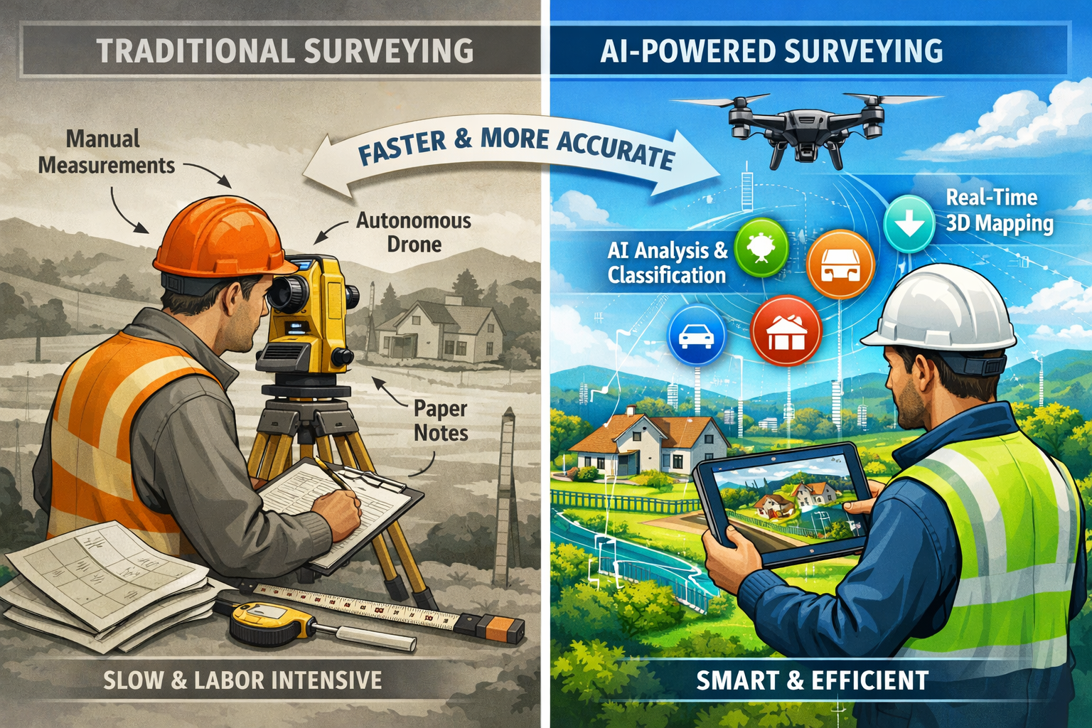
The property surveying industry stands at a pivotal moment. For decades, surveyors relied on traditional methods—manual measurements, time-intensive site visits, and painstaking data analysis. In 2026, AI-driven precision in property surveying is fundamentally transforming how professionals work, slashing turnaround times while delivering unprecedented accuracy. Leading firms worldwide are integrating artificial intelligence into their daily operations, moving beyond experimental applications to make AI a core component of standard surveying workflows.
This transformation isn't just about faster data collection. AI-driven precision in property surveying: revolutionizing workflows in 2026 represents a complete reimagining of the surveyor's role, client expectations, and project deliverables. From autonomous drones that adjust their flight paths in real-time to AI systems that instantly classify terrain features and detect anomalies, the technology is reshaping every aspect of the profession. Yet amid this automation, the human surveyor's expertise has become more critical than ever—not less.
Key Takeaways
✅ AI systems now handle routine data classification and anomaly detection automatically, freeing surveyors to focus on complex analysis and professional judgment that machines cannot replicate.
✅ Autonomous drones with predictive modeling capabilities can complete comprehensive property documentation in a single flight that previously required multiple site visits and manual processes.
✅ Real-time 3D digital twins have transitioned from premium offerings to expected deliverables, providing clients with interactive, continuously updated property models.
✅ Cloud-based collaboration platforms enable instant access to survey data, transforming client expectations around speed and interactivity in 2026.
✅ AI serves as a powerful tool rather than a replacement for qualified surveyors, whose critical evaluation and domain expertise remain essential for accurate property assessment.
The Evolution of AI in Property Surveying Workflows
From Manual Processes to Intelligent Automation
Traditional property surveying demanded significant manual effort. Surveyors spent hours sorting through raw data, identifying terrain features, and creating preliminary models. Human error was inevitable, and turnaround times stretched across weeks or months for complex projects.
AI-driven precision in property surveying has fundamentally altered this landscape. In 2026, AI systems embedded directly within core surveying workflows now instantly classify terrain, identify markers, flag anomalies, and generate preliminary surface models[1]. This represents a shift from AI as an experimental tool to AI as standard operational practice across the industry.
The transformation is particularly evident in data processing. Where surveyors once manually reviewed thousands of data points, AI algorithms now:
- Automatically categorize terrain features (vegetation, structures, water bodies, elevation changes)
- Detect anomalies that require human attention
- Generate preliminary models that serve as starting points for detailed analysis
- Flag inconsistencies in measurement data
- Identify potential survey markers and boundary indicators
This automation doesn't eliminate the surveyor's role. Instead, it elevates it. Professionals can now dedicate their expertise to complex analysis, client consultation, and critical decision-making rather than routine data sorting[7].
Real-World Implementation: How Leading Firms Integrate AI
Several pioneering surveying firms have documented substantial improvements after integrating AI into their workflows. These real-world case studies demonstrate the practical benefits of AI-driven precision in property surveying: revolutionizing workflows in 2026.
One mid-sized surveying firm reported reducing project turnaround times by 40% after implementing AI-powered data classification systems. Their surveyors now receive pre-processed datasets with terrain features already categorized, allowing them to move directly to analysis and verification.
Another firm specializing in building surveys integrated AI anomaly detection into their inspection workflows. The system automatically flags potential structural issues, moisture patterns, and unusual thermal signatures during initial data review. This early detection allows surveyors to focus their detailed inspection efforts on areas of genuine concern, improving both efficiency and thoroughness.
The consensus among early adopters is clear: AI handles the tedious, time-consuming tasks while amplifying the surveyor's ability to deliver value. As one industry expert noted, "AI and automation tools require relevant and accurate datasets"[7]—emphasizing that surveyor expertise remains fundamental to success.
Autonomous Drone Technology and Predictive Modeling
Advanced Flight Planning and Real-Time Adjustments
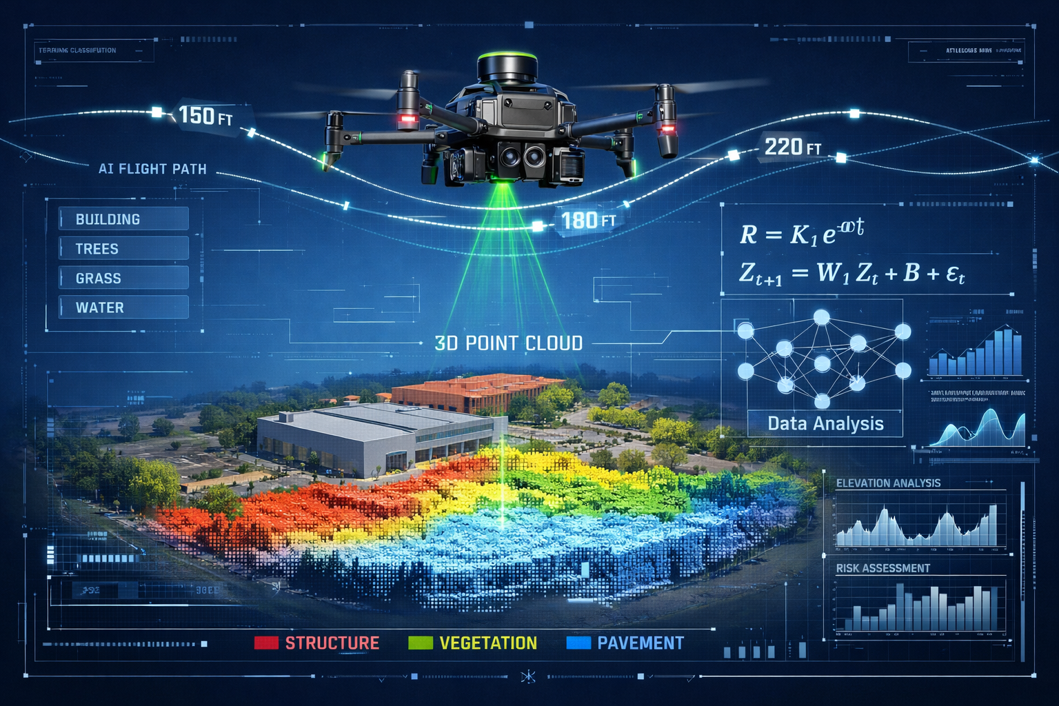
The integration of autonomous drone capabilities with predictive modeling represents one of the most visible transformations in property surveying. In 2026, drones don't simply follow pre-programmed flight paths—they make intelligent decisions in real-time to optimize data collection.
Modern surveying drones equipped with AI can:
🚁 Plan flight paths using predictive modeling that accounts for terrain complexity, lighting conditions, and data requirements
🚁 Automatically adjust altitude, angle, and sensor selection to achieve optimal readings for different property features[1]
🚁 Adapt to changing conditions such as weather shifts or unexpected obstacles
🚁 Prioritize data collection based on project requirements and quality thresholds
This level of autonomy dramatically reduces the need for multiple site visits. Multi-sensor drones can now capture comprehensive property documentation—including photogrammetry, LiDAR, thermal imaging, and multispectral data—in a single, highly detailed flight[1].
Multi-Sensor Integration for Comprehensive Documentation
The power of autonomous drones extends beyond flight efficiency. Multi-sensor integration allows simultaneous data collection across multiple dimensions, creating rich, layered property documentation.
A typical autonomous surveying drone in 2026 might carry:
| Sensor Type | Primary Function | Key Benefits |
|---|---|---|
| LiDAR | Precise elevation mapping | Penetrates vegetation, highly accurate terrain models |
| RGB Cameras | Visual documentation | High-resolution imagery, texture mapping |
| Thermal Imaging | Heat signature detection | Identifies insulation issues, moisture, structural problems |
| Multispectral | Vegetation analysis | Assesses landscape health, drainage patterns |
This comprehensive approach supports various survey types, from detailed Level 3 building surveys to specialized assessments like roof surveys. The AI coordinates data from all sensors, automatically aligning and processing information to create unified, multi-dimensional property models.
The efficiency gains are substantial. What once required separate visits by different specialists—structural inspectors, thermal imaging technicians, topographical surveyors—can now be accomplished in a single autonomous flight lasting minutes rather than hours.
Real-Time 3D Digital Twins Entering Standard Practice
From Premium Offering to Expected Deliverable
Perhaps no technology better exemplifies AI-driven precision in property surveying: revolutionizing workflows in 2026 than real-time 3D digital twins. These high-fidelity, interactive 3D models continuously update as new data is collected, allowing developers, engineers, and planners to visualize how land and structures behave under various conditions[1].
Just a few years ago, digital twins were premium offerings reserved for large-scale commercial projects. In 2026, they've become expected deliverables across residential and commercial surveying alike. Clients now anticipate receiving interactive 3D models they can explore, measure, and analyze from any device.
The transformation stems from several converging factors:
- AI-powered processing that generates 3D models in hours rather than weeks
- Cloud computing that makes complex models accessible via web browsers
- Standardized workflows that integrate digital twin creation into routine surveying
- Client education about the value and applications of interactive property models
Practical Applications of Digital Twin Technology
Real-time 3D digital twins serve multiple practical purposes throughout the property lifecycle:
For Property Buyers and Sellers:
- Virtual property tours that allow remote exploration of every room and feature
- Accurate measurements and spatial understanding before physical visits
- Documentation of property condition at specific points in time
For Developers and Planners:
- Visualization of how proposed changes will integrate with existing structures
- Analysis of site conditions, drainage patterns, and environmental factors
- Collaborative planning with architects, engineers, and stakeholders
For Maintenance and Facilities Management:
- Baseline documentation for tracking changes over time
- Planning renovations or repairs with precise spatial information
- Integration with structural engineering assessments
The AI component continuously enhances these models. As new survey data becomes available—whether from follow-up drone flights, manual inspections, or sensor networks—the digital twin automatically updates to reflect current conditions. This creates a living document that evolves with the property.
Cloud-Based Collaboration Platforms Transforming Client Expectations
The New Standard for Survey Deliverables
Client expectations have fundamentally shifted in 2026. The traditional model of delivering static PDF reports and CAD files no longer meets market demands. Cloud-based collaboration platforms offering instant access and interactivity have become the new standard[1].
Modern surveying clients expect:
✨ Instant file sharing with automatic syncing across team members
✨ 3D browser visualization that requires no specialized software
✨ Real-time revision syncing as survey data is updated
✨ Integrated communication with architects, engineers, and other professionals
✨ Mobile access to survey data from any location
This shift reflects broader digital transformation trends but has specific implications for property surveying. Projects that once required in-person meetings to review large-format plans now proceed with stakeholders collaborating asynchronously from multiple locations.
Enhanced Collaboration Across Project Teams
The collaboration benefits extend beyond client convenience. AI-driven precision in property surveying combined with cloud platforms enables unprecedented coordination among diverse project stakeholders.
Consider a typical property development project in 2026:
- Surveyor uploads initial site survey data to cloud platform
- AI processes the data, generating preliminary 3D models and terrain classification
- Architect accesses the model to begin design work, adding proposed structures
- Structural engineer reviews foundation requirements based on soil conditions
- Planning consultant assesses compliance with local regulations
- Client monitors progress and provides feedback through integrated comments
All of this occurs simultaneously, with each stakeholder working from the same continuously updated dataset. The AI flags potential conflicts—such as proposed construction in areas with drainage concerns or structures that exceed height restrictions—enabling early resolution.
This collaborative approach particularly benefits complex projects requiring specialized expertise, such as party wall matters or properties with non-standard construction features.
The Critical Role of Human Expertise in an AI-Driven Landscape
Why AI Cannot Replace Professional Judgment
Despite remarkable technological advances, AI-driven precision in property surveying: revolutionizing workflows in 2026 does not mean AI-only surveying. Critical limitations on AI autonomy have become increasingly clear through real-world testing.
A revealing study by Eddisons in early 2026 tested AI-generated lease summaries and property assessments. The results were sobering: AI overlooked important provisions and required qualified surveyor review to catch significant errors[3]. The technology excelled at processing large volumes of standard information but struggled with nuanced interpretation and contextual understanding.
This finding reinforces the consensus among industry experts: AI serves as a tool rather than a replacement for human expertise[3]. The surveyor's professional judgment remains essential for:
- Interpreting ambiguous data that doesn't fit standard patterns
- Assessing context that AI cannot fully understand
- Making judgment calls about property condition and risk
- Communicating findings to clients in accessible, actionable terms
- Ensuring compliance with professional standards and regulations
As one surveyor noted, "The AI can tell me there's an anomaly in the thermal data, but I need to determine whether it's a serious structural issue or simply a temporary condition that doesn't affect the property value."
The Evolving Surveyor Role: From Data Collection to Strategic Analysis
Rather than diminishing the surveyor's importance, AI has elevated the profession by eliminating tedious tasks and enabling focus on high-value activities[7]. The surveyor role in 2026 increasingly emphasizes:
Strategic Analysis:
- Interpreting AI-processed data within broader property and market context
- Identifying patterns and risks that require deeper investigation
- Providing expert opinions on complex property issues
Client Advisory:
- Translating technical findings into actionable recommendations
- Guiding clients through decision-making processes
- Explaining implications of survey findings for purchase, development, or maintenance
Quality Assurance:
- Verifying AI-generated outputs for accuracy and completeness
- Critically evaluating which tasks AI can perform efficiently
- Ensuring survey deliverables meet professional standards
Technology Integration:
- Selecting and implementing appropriate AI tools for specific projects
- Training AI systems with relevant, accurate datasets
- Staying current with emerging surveying technologies
This evolution mirrors transformations in other professional fields. Just as radiologists now use AI to flag potential issues while retaining diagnostic authority, surveyors use AI to process data while maintaining ultimate responsibility for professional judgment.
For clients seeking comprehensive property assessments—whether a Level 2 survey or specialized defect survey—the combination of AI efficiency and human expertise delivers superior outcomes to either approach alone.
Building Information Modeling (BIM) Integration and Geospatial Data
Seamless Integration Across the Construction Lifecycle
The integration of AI-driven precision in property surveying with Building Information Modeling (BIM) represents a significant advancement in 2026. Land surveyors increasingly collaborate with architects, engineers, and construction professionals to integrate geospatial data directly into BIM models[1].
This integration creates a seamless information flow throughout the construction lifecycle:
Pre-Construction:
- Accurate site surveys inform foundation design and placement
- Topographical data influences drainage and grading plans
- Existing structure documentation guides renovation planning
During Construction:
- Reality capture tracks progress against BIM models
- AI-powered comparison identifies deviations from plans
- Real-time updates keep all stakeholders informed
Post-Construction:
- As-built documentation creates baseline for future maintenance
- Digital twins enable facilities management and space planning
- Historical data supports future renovation or expansion projects
The AI component automates much of this integration. Survey data automatically populates relevant BIM fields, measurements update across linked documents, and the system flags inconsistencies between survey findings and design specifications.
Reducing Construction Conflicts Through Enhanced Planning
One of the most valuable benefits of BIM integration is conflict reduction. By combining precise survey data with detailed design models, potential issues surface during planning rather than construction.
AI algorithms analyze the combined dataset to identify:
- Spatial conflicts where proposed structures intersect with existing features
- Elevation issues that could affect drainage or accessibility
- Utility conflicts where new construction might impact existing infrastructure
- Regulatory compliance concerns based on zoning and building codes
Early identification of these issues saves substantial time and expense. A foundation redesign during the planning phase costs a fraction of modifications required after construction begins.
This integrated approach particularly benefits complex projects involving structural engineer reports or properties requiring property certification for specific uses.
Reality Capture as Integral Project Management Tool
Visual Documentation and Progress Tracking
Reality capture using AI and machine learning has evolved beyond simple documentation to become a common visual language for project management[5]. In 2026, reality capture serves multiple critical functions:
Baseline Documentation:
- Precise recording of existing conditions before work begins
- Creating reference points for measuring progress
- Establishing accountability for pre-existing issues
Progress Monitoring:
- Regular capture sessions document construction advancement
- AI-powered comparison highlights completed work and delays
- Visual evidence supports progress billing and milestone verification
Quality Control:
- Comparing as-built conditions to design specifications
- Identifying workmanship issues requiring correction
- Documenting compliance with building codes and standards
The AI component transforms raw capture data into actionable insights. Rather than simply providing 3D point clouds or panoramic images, modern reality capture systems automatically:
- Measure completion percentages for different project phases
- Flag areas where construction deviates from approved plans
- Track material quantities and usage
- Generate progress reports for stakeholders
Enabling Real-Time Collaboration Across Stakeholders
Reality capture creates a common visual language that all project stakeholders can understand, regardless of technical expertise[5]. This democratization of project information facilitates better communication and decision-making.
A property owner without construction knowledge can view reality capture data and understand:
- What work has been completed
- How the finished project will look and function
- Whether construction is proceeding according to schedule
- Areas where changes or corrections are needed
This transparency benefits all parties. Contractors can visually demonstrate progress, clients can make informed decisions about change orders, and surveyors can document conditions for stock condition surveys or other specialized assessments.
The integration of reality capture with AI-powered analysis creates a powerful combination. The technology handles routine monitoring and measurement, while human experts focus on interpreting findings and guiding project decisions.
Property Valuation Enhanced by Multi-Factor Analysis
Beyond Traditional Appraisal Methods
AI-driven precision in property surveying extends beyond physical measurement to transform property valuation. In 2026, AI systems analyze thousands of data points to estimate property values with impressive accuracy[4], complementing and enhancing traditional appraisal methods.
Modern AI valuation systems consider:
📊 Local market trends including recent sales, listing patterns, and price movements
📊 School ratings and educational quality indicators
📊 Traffic patterns and commute times to major employment centers
📊 Nearby business activity including retail, dining, and services
📊 Environmental factors such as parks, water features, and green spaces
📊 Infrastructure development including transportation and utilities
📊 Crime statistics and neighborhood safety indicators
📊 Future development plans that might affect property values
This multi-factor analysis provides a more comprehensive valuation than traditional methods relying primarily on comparable sales. The AI identifies subtle patterns and correlations that human appraisers might miss while processing data at scale impossible for manual analysis.
Practical Applications for Different Property Types
The enhanced valuation capabilities serve different purposes across property types:
Residential Properties:
- Accurate pricing for buyers and sellers
- Refinancing and equity assessments
- Probate valuation for estate settlement
- Matrimonial valuation for divorce proceedings
Commercial Properties:
- Investment analysis and return projections
- Commercial valuation for transactions
- Portfolio assessment for institutional investors
- Lease rate optimization based on market conditions
Specialized Situations:
- Help to Buy valuations for government programs
- Right to Buy valuation for social housing purchases
- RICS Shared Ownership valuations for partial ownership schemes
The AI-enhanced approach doesn't replace professional valuers but provides them with richer data and insights. Qualified surveyors review AI-generated valuations, apply professional judgment to unique property features, and ensure compliance with RICS standards and regulatory requirements.
Predictive Market Analytics for Investment Decisions
Forecasting Market Trends with AI Algorithms
Beyond individual property valuation, predictive algorithms now analyze live market signals to forecast broader trends and investment opportunities[4]. This capability transforms how investors, developers, and property professionals approach market analysis in 2026.
AI-powered predictive analytics examine:
- Rental demand patterns across different property types and locations
- Local job growth and employment trends that drive housing demand
- New construction activity that might increase supply
- Consumer behavior shifts in housing preferences and requirements
- Economic indicators including interest rates and lending conditions
- Demographic changes affecting housing needs
- Infrastructure investments that enhance neighborhood desirability
These algorithms process real-time data from multiple sources—government statistics, private databases, social media sentiment, search trends, and transaction records—to identify emerging patterns before they become obvious to human observers.
Investment Strategy Applications
The predictive insights enable more informed investment decisions:
Market Timing:
- Identifying markets likely to heat up before price increases accelerate
- Recognizing early signs of market cooling to adjust strategies
- Forecasting rent increases to optimize acquisition timing
Location Selection:
- Highlighting neighborhoods with strong growth potential
- Identifying areas where infrastructure investment will drive appreciation
- Avoiding markets with oversupply or declining fundamentals
Property Type Optimization:
- Forecasting demand shifts between property types (single-family, multi-family, commercial)
- Identifying emerging property use trends (remote work impact, mixed-use demand)
- Optimizing portfolio composition for changing market conditions
Risk Management:
- Assessing market volatility and downside risk
- Identifying potential return scenarios under different economic conditions
- Diversifying holdings based on correlation analysis
Professional surveyors increasingly incorporate these predictive insights into their advisory services, helping clients understand not just current property value but future potential and risks.
3D Property Visualization Transforming Buyer Experience
Interactive Virtual Tours and AI Enhancement
The buyer experience has fundamentally changed through 3D property visualization enhanced by AI[4]. In 2026, prospective buyers can explore properties interactively from any location, with AI tools adjusting lighting, highlighting features, and even visualizing furniture placement.
Modern virtual property tours offer:
🏠 Complete spatial exploration allowing movement through every room and outdoor space
🏠 Accurate measurements available with a simple click on any surface
🏠 Lighting adjustments showing how spaces appear at different times of day
🏠 Feature highlighting that draws attention to important property elements
🏠 Furniture visualization demonstrating how spaces can be utilized
🏠 Renovation previews showing potential improvements and their impact
This technology particularly benefits buyers who are:
- Relocating from distant locations
- Evaluating multiple properties efficiently
- Requiring detailed spatial understanding before physical visits
- Assessing properties for specific uses or accessibility needs
The AI enhancement goes beyond static 3D models. Machine learning algorithms analyze buyer behavior within virtual tours—which rooms they spend time in, which features they examine closely, which angles they prefer—to personalize the experience and provide sellers with valuable insights about buyer interests.
From Static Photos to Lifelike Experiences
The shift from traditional property photography to interactive 3D visualization represents a fundamental change in how properties are marketed and evaluated. Where buyers once relied on carefully curated photos that might misrepresent spatial relationships or hide defects, 3D visualization provides transparent, comprehensive documentation.
This transparency benefits all parties:
Buyers gain:
- Realistic understanding of property condition and layout
- Ability to revisit and re-examine properties without scheduling additional viewings
- Confidence in remote property evaluation
- Better preparation for physical inspections
Sellers benefit from:
- Broader buyer reach including international and remote purchasers
- Reduced time spent on unqualified viewings
- Faster decision-making by serious buyers
- Enhanced property presentation
Surveyors leverage visualization for:
- Remote preliminary assessments before site visits
- Client education about property features and issues
- Documentation supporting building survey reports
- Enhanced communication of findings
The technology integrates seamlessly with other AI-driven surveying capabilities, creating a comprehensive digital property documentation ecosystem.
Emerging Technologies and Future Developments
Trimble AI Studio and Custom AI Solutions
The launch of Trimble AI Studio in early 2026 represents a significant development for surveying professionals[7]. This platform enables users to build and refine custom AI agents across the Trimble ecosystem, providing tools to develop tailored AI solutions for specific surveying challenges.
This democratization of AI development allows surveying firms to:
- Create specialized AI models for unique property types or assessment needs
- Train algorithms on proprietary datasets to improve accuracy
- Automate firm-specific workflows and processes
- Integrate AI capabilities with existing software and systems
The ability to customize AI solutions addresses a key limitation of generic AI tools: they may not account for regional variations, specialized property types, or unique client requirements. Custom AI development enables firms to maintain competitive advantages while benefiting from AI efficiency.
The Road Ahead: Continued Innovation in 2026 and Beyond
AI-driven precision in property surveying: revolutionizing workflows in 2026 represents current state-of-the-art, but innovation continues at a rapid pace. Emerging developments include:
Enhanced Sensor Technology:
- Higher-resolution imaging capabilities
- New sensor types for specialized property assessment
- Miniaturization enabling deployment in constrained spaces
- Improved battery life and flight time for autonomous systems
Advanced AI Capabilities:
- Better contextual understanding and nuanced interpretation
- Improved anomaly detection with reduced false positives
- Predictive maintenance algorithms for existing structures
- Natural language interfaces for client interaction
Integration and Standardization:
- Industry-wide data standards facilitating seamless information exchange
- Improved interoperability between different software platforms
- Regulatory frameworks addressing AI use in property assessment
- Professional training programs for AI-enhanced surveying
Sustainability Applications:
- Energy efficiency assessment and optimization
- Environmental impact analysis
- Green building certification support
- Climate resilience evaluation
The surveying profession continues to evolve, with AI serving as a powerful enabler of enhanced service delivery rather than a threat to professional expertise.
Practical Implementation: Getting Started with AI-Enhanced Surveying
Assessing Your Firm's AI Readiness
For surveying firms considering AI integration, a structured assessment helps identify opportunities and priorities:
Current Workflow Analysis:
- Which tasks consume the most time?
- Where do bottlenecks typically occur?
- What client complaints or requests are most common?
- Which processes have the highest error rates?
Technology Infrastructure:
- What hardware and software currently in use?
- Are systems cloud-compatible?
- What is the budget for technology investment?
- What technical expertise exists within the team?
Data Quality and Availability:
- What historical data is available for AI training?
- How consistent is data collection and storage?
- Are datasets properly organized and accessible?
- What data quality issues need addressing?
Team Capabilities:
- What is the team's comfort level with new technology?
- What training needs exist?
- Who will champion AI implementation?
- How will roles and responsibilities evolve?
Phased Implementation Strategy
Successful AI integration typically follows a phased approach rather than attempting comprehensive transformation immediately:
Phase 1: Pilot Projects (Months 1-3)
- Select one or two specific use cases for initial AI implementation
- Choose projects with clear success metrics
- Limit scope to manage risk and learning curve
- Document results and lessons learned
Phase 2: Workflow Integration (Months 4-6)
- Expand successful pilots to broader workflow integration
- Develop standard operating procedures incorporating AI tools
- Train team members on new processes
- Refine AI configurations based on real-world performance
Phase 3: Advanced Capabilities (Months 7-12)
- Implement more sophisticated AI applications
- Develop custom AI solutions for firm-specific needs
- Integrate AI across multiple service offerings
- Establish firm as AI-capable provider in the market
Phase 4: Continuous Improvement (Ongoing)
- Monitor AI performance and accuracy
- Update training data and algorithms
- Stay current with emerging technologies
- Optimize processes based on accumulated experience
This measured approach allows firms to build expertise, manage costs, and demonstrate value before making larger commitments.
Addressing Common Concerns and Challenges
Data Privacy and Security Considerations
The integration of AI-driven precision in property surveying raises important data privacy and security questions that responsible firms must address:
Client Data Protection:
- Ensuring survey data is stored securely and accessed only by authorized personnel
- Implementing encryption for data transmission and storage
- Establishing clear data retention and deletion policies
- Complying with GDPR and other privacy regulations
AI Training Data:
- Using anonymized data for AI training when possible
- Obtaining appropriate permissions for data use
- Protecting proprietary client information
- Maintaining confidentiality of sensitive property details
Cloud Platform Security:
- Selecting reputable cloud providers with robust security measures
- Understanding data storage locations and jurisdictional issues
- Implementing access controls and authentication requirements
- Maintaining audit trails of data access and modifications
Professional Liability:
- Ensuring AI-generated outputs are properly reviewed
- Maintaining professional indemnity insurance coverage
- Documenting AI use in survey processes
- Establishing clear accountability for survey accuracy
Managing Client Expectations
As AI capabilities expand, managing client expectations becomes increasingly important:
Realistic Timelines:
- While AI accelerates many processes, complex surveys still require appropriate time
- Setting clear expectations about deliverable timing
- Explaining factors that influence project duration
- Communicating proactively about any delays
Understanding AI Limitations:
- Educating clients that AI supports but doesn't replace professional judgment
- Explaining which aspects of surveys involve AI and which require human expertise
- Managing expectations about accuracy and certainty
- Clarifying the surveyor's continuing professional responsibility
Value Communication:
- Articulating how AI enhances survey quality and thoroughness
- Demonstrating the benefits of advanced visualization and analysis
- Justifying fees based on enhanced deliverables and expertise
- Differentiating AI-enhanced services from basic offerings
Technology Access:
- Ensuring clients can access and use digital deliverables
- Providing training or support for cloud platforms and 3D models
- Offering alternative formats when needed
- Maintaining accessibility for clients with varying technical capabilities
Conclusion: Embracing AI While Maintaining Professional Excellence
AI-driven precision in property surveying: revolutionizing workflows in 2026 represents a transformative moment for the profession. The technology delivers undeniable benefits—faster turnaround times, enhanced accuracy, comprehensive documentation, and improved client experiences. Leading firms integrating AI into their daily operations report substantial efficiency gains while maintaining the highest professional standards.
Yet the transformation is not about replacing surveyors with machines. Rather, it's about empowering professionals to deliver greater value by eliminating tedious tasks and enabling focus on complex analysis, strategic advice, and critical judgment that only human expertise can provide.
The surveyor's role has evolved, not diminished. In 2026, successful surveyors combine technological proficiency with deep domain knowledge, using AI as a powerful tool while maintaining ultimate responsibility for professional judgment and client service.
"AI and automation tools require relevant and accurate datasets. The surveyor's expertise in critically evaluating which tasks AI can perform efficiently has become more important, not less." – Industry Expert[7]
Actionable Next Steps
For surveying professionals looking to embrace AI-enhanced workflows:
- Assess your current processes to identify high-impact opportunities for AI integration
- Start with focused pilot projects that demonstrate clear value and build team confidence
- Invest in training to ensure your team can effectively leverage AI tools
- Maintain professional standards by reviewing all AI-generated outputs with expert judgment
- Communicate value to clients about how AI enhances the quality and comprehensiveness of your services
- Stay informed about emerging technologies and industry best practices
- Partner with experienced surveyors who can guide your AI implementation journey
The future of property surveying combines the precision and efficiency of AI with the irreplaceable value of human expertise. Firms that successfully integrate both will lead the profession in delivering exceptional client outcomes while maintaining the highest standards of professional excellence.
Whether you're considering a comprehensive building survey, specialized asbestos surveys, or any property assessment need, choosing surveyors who leverage AI-driven precision while maintaining professional expertise ensures you receive the most accurate, thorough, and valuable service available in 2026.
References
[1] Future Land Surveying 2026 – https://haller-blanchard.com/future-land-surveying-2026/
[2] Revolutionizing Property Surveys How Ai And Machine Learning Are Predicting Risks In 2026 – https://nottinghillsurveyors.com/blog/revolutionizing-property-surveys-how-ai-and-machine-learning-are-predicting-risks-in-2026
[3] How Ai Is Changing Building Surveying Opportunities And Limitations – https://www.eddisons.com/insights/how-ai-is-changing-building-surveying-opportunities-and-limitations
[4] How Ai Is Changing Real Estate In The Usa – https://www.rentana.io/blog/how-ai-is-changing-real-estate-in-the-usa
[5] Doubling Down On Digital – https://amerisurv.com/2026/02/01/doubling-down-on-digital/
[7] How Ai Is Changing The Role Of The Surveyor In Aec – https://www.gim-international.com/content/article/how-ai-is-changing-the-role-of-the-surveyor-in-aec