
The surveying industry is experiencing a technological revolution that's transforming how professionals capture, analyze, and deliver spatial data. The 3D Laser Scanning Boom: Enhancing Accuracy in Surveying and Mapping Services represents more than just an equipment upgrade—it's a fundamental shift in how surveyors approach complex projects, from urban infrastructure development to heritage preservation. As we navigate through 2026, this advanced technology has moved from specialized applications to mainstream adoption, offering unprecedented precision, efficiency, and safety benefits that traditional surveying methods simply cannot match.
Modern 3D laser scanning technology has evolved dramatically over the past decade. What once required expensive, bulky equipment and extensive processing time now happens in real-time, with scanners capturing two million points per second while costs have dropped significantly.[1] This democratization of high-precision scanning technology means that surveying firms of all sizes can now integrate these powerful tools into their workflows, delivering exceptional value to clients across construction, engineering, urban planning, and facility management sectors.
Key Takeaways
✅ Unprecedented Speed and Accuracy: Modern 3D laser scanners collect millions of data points in minutes, completing projects in hours that traditionally required days or weeks, while delivering millimeter-level precision.[1]
✅ Enhanced Safety and Remote Capabilities: Surveyors can now safely capture data from hazardous environments like busy roadways, mines, and tunnels through extended scanning ranges and autonomous devices that enable virtual surveying.[1]
✅ Comprehensive Technology Integration: Today's scanning systems incorporate advanced sensors, GPS, IMUs, and photodetectors that work seamlessly with existing software packages, creating continuous workflows from field capture to stakeholder delivery.[2]
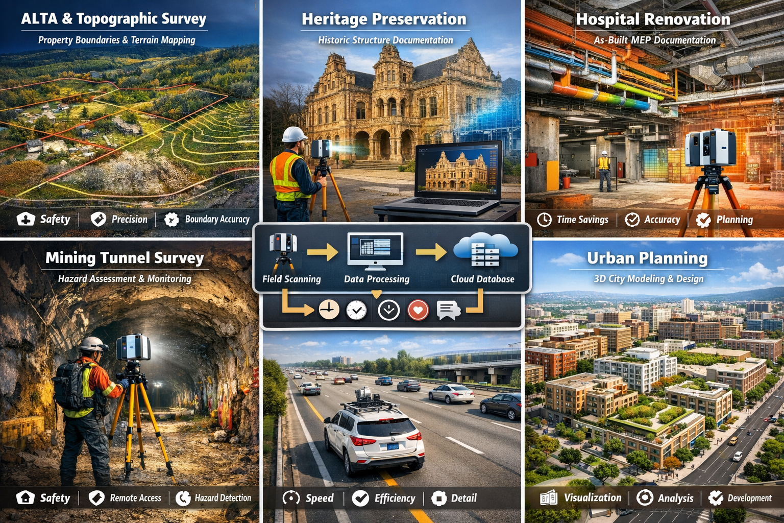
✅ Diverse Application Versatility: From ALTA surveys and as-built documentation to infrastructure assessments and heritage preservation, 3D laser scanning supports virtually every surveying discipline with exceptional detail and reliability.[1]
✅ Cost-Effective Implementation: Declining hardware costs combined with modular software integration and reduced site visit requirements make 3D laser scanning increasingly accessible and financially advantageous for surveying professionals.[1]
Understanding the 3D Laser Scanning Technology Revolution
What Makes 3D Laser Scanning Different
Traditional surveying methods rely on measuring individual points and features manually, creating time-consuming processes that can miss critical details. In contrast, 3D laser scanning captures complete environments as dense point clouds—digital representations containing millions of precisely measured coordinates that recreate physical spaces in extraordinary detail.
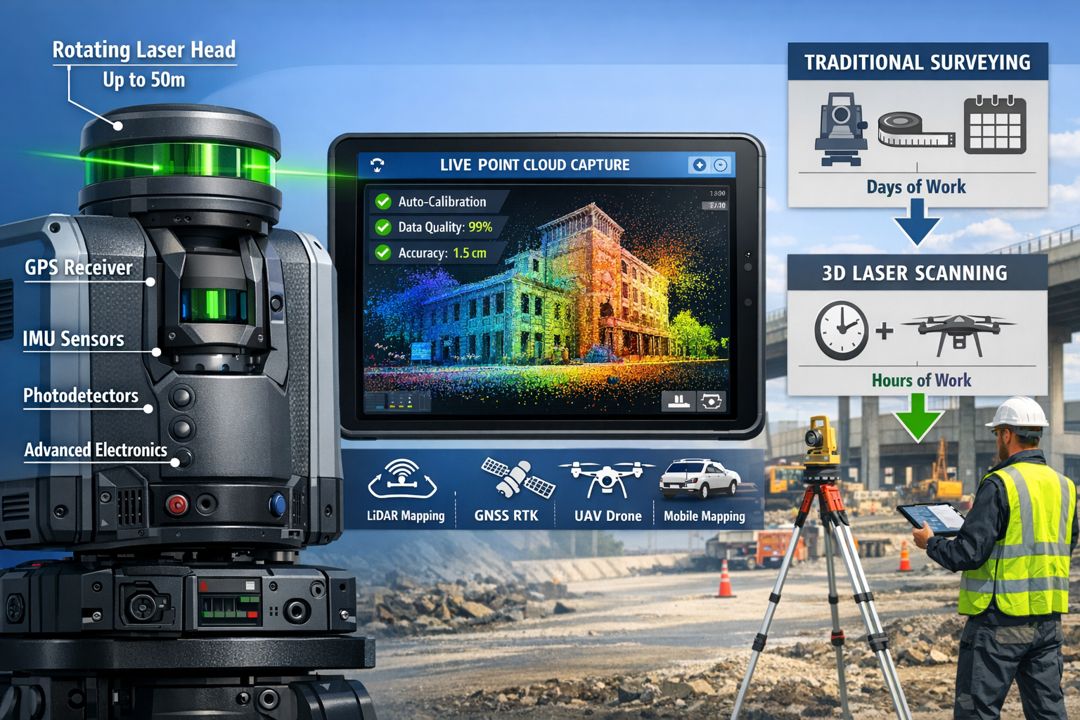
The technology works by emitting rapid laser pulses that bounce off surfaces and return to the scanner. Advanced sensors measure the time-of-flight for each pulse, calculating exact distances with remarkable precision. Modern systems integrate multiple technologies simultaneously:[2]
- Laser beams for distance measurement
- GPS receivers for global positioning
- Inertial Measurement Units (IMUs) for orientation tracking
- Photodetectors for signal reception
- High-resolution cameras for texture capture
- Advanced processing electronics for real-time calculations
This comprehensive sensor fusion enables surveyors to accurately calculate structures' and surfaces' coordinates even in challenging environments where traditional methods struggle.[2]
The Performance Leap in Modern Scanning Equipment
The improvements in scanning technology over the past decade have been nothing short of remarkable. Hardware costs have decreased substantially while performance capabilities have skyrocketed. Contemporary scanners now reach speeds of two million points per second, enabling comprehensive data capture that would have been impossible just years ago.[1]
Recent industry showcases, including Geo Week 2026, have demonstrated cutting-edge innovations like precision green laser technology with 50-meter range visible in daylight conditions—a significant advancement that allows surveyors to work effectively regardless of ambient lighting.[5] Dual-camera systems now provide real-time 3D guidance, helping operators ensure complete coverage while still in the field.
Quality assurance features have evolved equally impressively. Modern scanners like the Trimble X9 offer automatic calibration to ensure consistent data quality between scans, with real-time review capabilities that detect gaps and correct errors without requiring return site visits.[1] This immediate feedback loop dramatically reduces project risk and accelerates delivery timelines.
How 3D Laser Scanning Boom: Enhancing Accuracy in Surveying and Mapping Services Transforms Project Workflows
Dramatic Efficiency Gains Across Project Phases
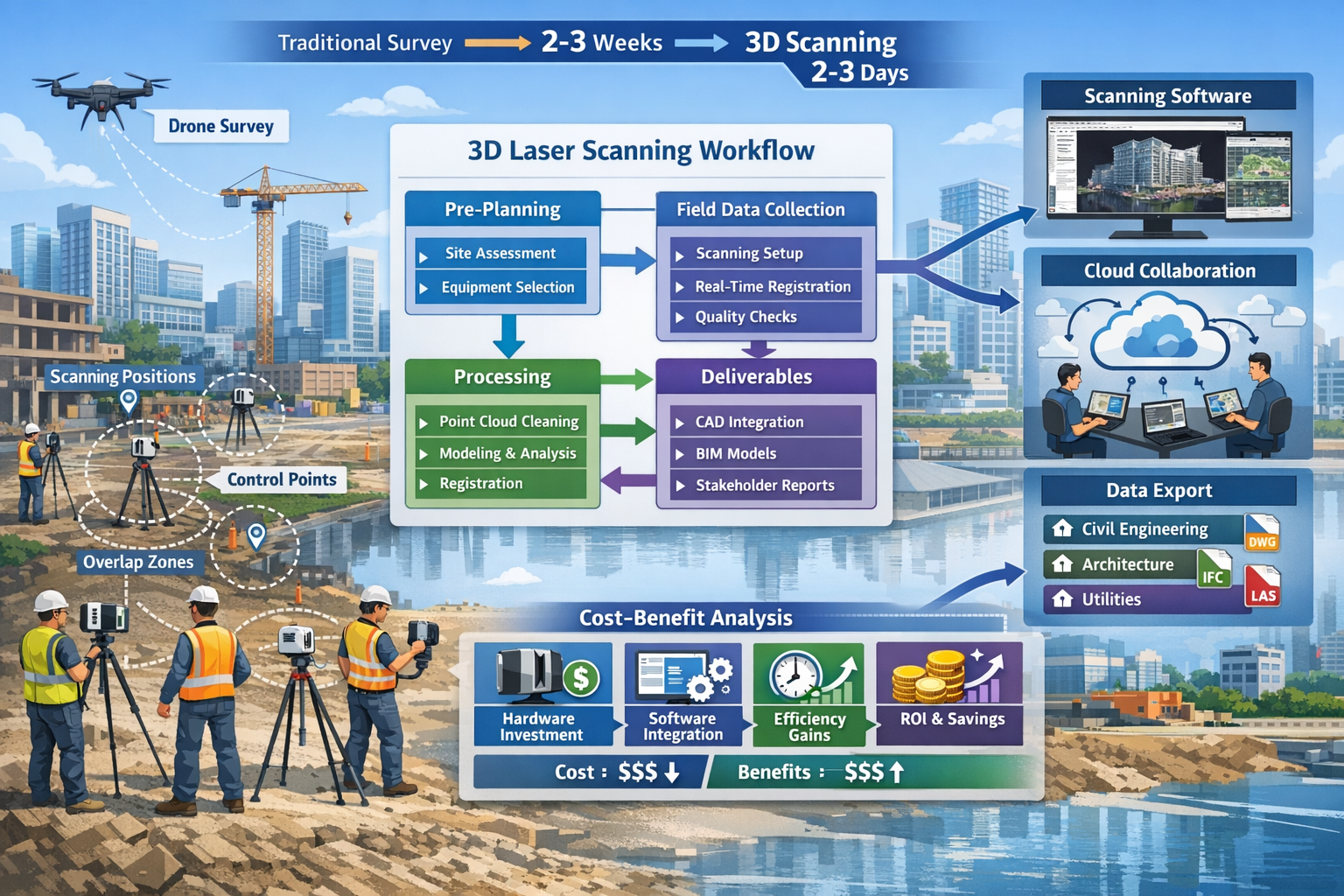
The efficiency improvements delivered by 3D laser scanning fundamentally change project economics and timelines. Work that traditionally consumed days or even weeks can now be completed in hours.[1] This acceleration doesn't compromise quality—quite the opposite. The comprehensive data capture ensures nothing gets missed during initial site visits.
Consider a typical infrastructure assessment project. Traditional surveying might require:
- Multiple site visits over several days
- Manual measurements of hundreds of individual points
- Sketching and note-taking to capture context
- Return visits when office analysis reveals data gaps
- Weeks of processing to create deliverable drawings
With 3D laser scanning, the same project transforms into:
- Single comprehensive site visit (often just hours)
- Millions of data points captured automatically
- Complete visual context through integrated photography
- Real-time quality checks ensuring complete coverage
- Days (not weeks) of processing with automated workflows
The in-field registration and auto calibration capabilities of modern scanners minimize errors and dramatically reduce the need for return visits—a significant cost savings when projects involve distant or difficult-to-access sites.[1]
Comprehensive Data Capture for Complex Environments
One of the most powerful advantages of 3D laser scanning is its ability to capture millions of data points in a matter of minutes, delivering highly accurate and detailed representations of landscapes, structures, and objects.[1] This comprehensive approach ensures that even unexpected details are documented—information that might prove critical during later project phases.
For renovation and retrofit projects, this completeness is invaluable. When documenting existing conditions in hospitals, hotels, or large commercial buildings, traditional surveys might miss concealed piping, ductwork conflicts, or structural elements hidden above ceilings. A comprehensive point cloud captures everything visible from the scanner positions, creating a complete digital record that designers can reference indefinitely.
The technology excels particularly in environments where traditional surveying faces challenges:
🏗️ Complex Industrial Facilities: Capturing dense piping networks, equipment layouts, and structural frameworks with precision calibration requirements
🏛️ Heritage Structures: Documenting intricate architectural details, irregular geometries, and deterioration patterns for preservation projects
🌆 Urban Infrastructure: Recording complete streetscapes including utilities, signage, landscaping, and building facades for planning applications
⛏️ Mining Operations: Mapping tunnel profiles, stockpile volumes, and excavation progress in challenging underground conditions
Integrating 3D Laser Scanning into Professional Surveying Workflows
Planning and Preparation for Successful Scanning Projects
Successful integration of 3D laser scanning into existing workflows begins with thoughtful planning. While the technology offers tremendous capabilities, maximizing its value requires understanding project requirements and selecting appropriate approaches.
Pre-project considerations should include:
| Planning Element | Key Questions | Impact on Workflow |
|---|---|---|
| Project Scope | What level of detail is required? Which areas must be captured? | Determines scanner selection and setup density |
| Deliverable Requirements | What formats do stakeholders need (CAD, BIM, point cloud)? | Influences processing workflow and software choices |
| Site Conditions | Are there access restrictions, safety hazards, or environmental challenges? | Affects equipment selection and scanning approach |
| Timeline Constraints | What are the critical deadlines for data delivery? | Determines field crew size and processing resources |
| Integration Needs | How will scan data integrate with existing project information? | Guides coordinate system and registration strategy |
Understanding these elements upfront ensures efficient field operations and smooth data processing. For professionals considering how scanning complements traditional survey methods, reviewing comprehensive condition survey reports can provide valuable context about thorough property documentation approaches.
Field Data Collection Best Practices
Effective field scanning requires balancing coverage completeness with efficiency. Modern scanners make data capture remarkably fast, but strategic planning ensures optimal results without unnecessary redundancy.
Key field workflow elements include:
-
Control Point Establishment: Setting up survey control that ties scan data to project coordinate systems and enables accurate registration between scan positions
-
Strategic Scanner Positioning: Selecting scan locations that provide overlapping coverage while minimizing occlusions and ensuring complete data capture
-
Real-Time Quality Verification: Using scanner displays and companion software to review data completeness while still on-site, identifying and addressing gaps immediately
-
Systematic Documentation: Recording scanner positions, noting environmental conditions, and photographing site context for later reference during processing
-
Safety Protocol Adherence: Maintaining awareness of hazardous conditions while leveraging the scanner's ability to extend range and distance operators from dangerous situations[1]
The safety advantages of 3D laser scanning deserve special emphasis. Surveyors can now capture detailed information from hazardous environments like busy roadways, active construction zones, mines, and tunnels while maintaining safe distances.[1] Remote and autonomous scanning devices even enable "virtual surveying" where physical presence in dangerous areas becomes unnecessary.
Processing and Delivering Actionable Results
Raw scan data requires processing to become useful deliverables. Modern workflows have streamlined this phase considerably through software integration and automation, but understanding the process helps optimize results.
Typical processing workflow stages:
Registration and Alignment: Combining individual scans into unified coordinate systems using common features, targets, or GPS positions to create seamless point cloud datasets
Cleaning and Filtering: Removing extraneous data like vegetation, people, or vehicles that aren't relevant to project objectives while retaining necessary detail
Classification and Extraction: Identifying specific features (walls, floors, equipment, utilities) and extracting them as distinct elements for modeling or analysis
Modeling and Documentation: Creating CAD drawings, BIM models, or specialized deliverables from the point cloud data according to project requirements
Quality Control and Delivery: Verifying accuracy, checking completeness, and packaging data in formats stakeholders can readily use
Scanning software increasingly integrates with hardware for continuous workflows that minimize manual intervention.[1] Many platforms now offer scanning modules that add to existing software packages, limiting additional purchases while enabling improved capabilities. Cloud databases facilitate stakeholder communication by allowing team members to access, review, and collaborate on scan data from any location.[1]
For surveyors managing complex projects, understanding how different survey types complement scanning technology proves valuable. Resources like what surveyors look for in house surveys provide insights into comprehensive property assessment approaches that scanning can enhance.
The 3D Laser Scanning Boom: Enhancing Accuracy in Surveying and Mapping Services Across Industries
Construction and Infrastructure Applications
The construction industry has emerged as one of the primary beneficiaries of 3D laser scanning technology. From initial site surveys through project closeout, scanning delivers value at every phase.
Pre-construction applications include:
- ALTA/NSPS Land Title Surveys: Capturing boundary evidence, improvements, easements, and topographic features with exceptional accuracy for commercial property transactions[1]
- Topographic Surveys: Recording existing terrain conditions, drainage patterns, and site features for design development
- Utility Mapping: Documenting visible infrastructure and correlating with subsurface utility information for conflict avoidance
During construction, scanning supports:
- Progress Monitoring: Comparing as-built conditions against design models to verify compliance and identify deviations early
- Quality Assurance: Measuring dimensional accuracy of structural elements, ensuring they meet specification tolerances
- Clash Detection: Identifying conflicts between building systems before they cause costly field coordination issues
Post-construction deliverables benefit from:
- As-Built Documentation: Creating comprehensive records of completed work for facility management and future renovation planning[1]
- Facility Management Integration: Populating BIM models with accurate as-built data for ongoing operations and maintenance
- Warranty and Compliance: Providing verified documentation of installed conditions for warranty claims and regulatory compliance
Infrastructure projects particularly benefit from scanning's ability to capture complex environments efficiently. Highway assessments, bridge inspections, railway corridors, and utility networks all involve extensive linear assets where traditional surveying becomes extremely time-consuming. Mobile mapping systems now allow surveyors to create detailed 3D models from indoor or outdoor environments without bulky equipment, enabling digital replicas without extensive wait times.[3]
Engineering and Industrial Facility Applications
Engineering disciplines increasingly rely on 3D laser scanning for projects requiring exceptional precision and comprehensive documentation. The technology delivers comprehensive detail for use in:[2]
Architectural Engineering:
- Historic building documentation and preservation
- Renovation design for existing structures
- Facade analysis and restoration planning
- Space planning and interior design verification
Civil Engineering:
- Bridge condition assessment and load rating
- Dam safety inspections and monitoring
- Retaining wall analysis and design
- Roadway and railway corridor mapping
Mining Engineering:
- Tunnel profile measurement and overbreak analysis
- Stockpile volume calculations
- Pit progression monitoring
- Underground void mapping and stability assessment
Industrial and Process Engineering:
- Piping and ductwork design for complex facilities[2]
- Equipment installation with precision calibration requirements[2]
- Retrofit and modification projects in operating plants[2]
- Maintenance planning and turnaround optimization
For industrial facilities, the ability to capture complete existing conditions without disrupting operations provides enormous value. Scanning can document equipment layouts, piping networks, and structural frameworks during brief access windows, then enable extensive design work to occur off-site using the point cloud data.
Professionals working across these disciplines often require specialized survey expertise. Understanding different types of surveyors and their specializations helps project teams engage the right expertise for scanning integration.
Heritage Preservation and Cultural Documentation
Cultural heritage preservation represents one of the most compelling applications for 3D laser scanning technology. Historic structures often feature irregular geometries, intricate details, and fragile conditions that make traditional surveying challenging and potentially damaging.
Scanning offers non-contact documentation that captures:
- Architectural details at millimeter resolution
- Structural deformation and deterioration patterns
- Complete geometric records for restoration planning
- Digital archives preserving cultural assets for future generations
The comprehensive nature of point cloud data means that researchers, conservators, and designers can return to the digital record repeatedly, extracting information for purposes not anticipated during original data collection. This "measure once, use many times" capability provides exceptional long-term value.
International heritage organizations increasingly mandate laser scanning for significant restoration projects, recognizing its superiority for documenting existing conditions and monitoring conservation interventions over time.
Emerging Trends and Future Developments in Surveying Technology
Advanced Surveying Technologies Shaping 2026 and Beyond
The 3D laser scanning boom exists within a broader ecosystem of advanced surveying technologies that increasingly work together synergistically. Industry trends for 2026 include:[3]
LiDAR Mapping: Airborne and mobile LiDAR systems that capture vast areas rapidly, particularly valuable for corridor mapping, forestry applications, and regional terrain modeling
GNSS RTK Systems: Real-time kinematic positioning that provides centimeter-level accuracy for control networks and direct georeferencing of scan data
UAV Photogrammetry: Drone-based imaging that creates 3D models through photogrammetric processing, complementing terrestrial scanning for complete site coverage
Mobile Mapping Systems: Vehicle-mounted or backpack-based platforms that capture continuous data while moving, dramatically accelerating large-area surveys[3]
Real-Time Data Processing: AI-powered workflows that begin processing and analyzing data during field collection, enabling immediate insights and decision-making[3]
The convergence of these technologies creates powerful capabilities. A comprehensive infrastructure survey might combine:
- Terrestrial laser scanning for detailed structure documentation
- Mobile mapping for corridor and streetscape capture
- UAV photogrammetry for aerial context and inaccessible areas
- GNSS RTK for precise control and georeferencing
- Real-time processing for immediate quality verification
This multi-sensor approach delivers more complete information faster than any single technology could achieve alone.
Autonomous and Remote Scanning Capabilities
The evolution toward autonomous scanning devices represents a significant trend that will accelerate through the coming years. Remote operation capabilities enable surveyors to deploy scanners in hazardous or inaccessible locations, then control them from safe distances or even different locations entirely.[1]
Applications for autonomous scanning include:
- Active Construction Zones: Deploying scanners during off-hours or in areas where human presence creates safety risks
- Environmental Monitoring: Installing permanent or semi-permanent scanners that periodically capture data to track changes over time
- Disaster Response: Rapidly documenting damaged structures or hazardous sites without exposing personnel to danger
- Remote Locations: Operating scanners in distant or difficult-to-access areas with minimal on-site personnel requirements
These capabilities align with broader industry trends toward digital twins and continuous monitoring, where physical assets are represented by constantly updated digital models that reflect current conditions.
Artificial Intelligence and Automated Feature Extraction
Artificial intelligence is transforming how scan data gets processed and analyzed. Traditional workflows required manual identification and extraction of features from point clouds—a time-consuming process requiring skilled technicians. AI-powered tools now automate much of this work, recognizing features like walls, doors, windows, pipes, and equipment without human intervention.
AI applications in scanning workflows include:
- Automated classification of point cloud data into meaningful categories
- Feature recognition that identifies building elements and infrastructure components
- Change detection that compares successive scans to identify modifications or deterioration
- Quality control that flags potential errors or data gaps requiring attention
- Intelligent modeling that generates CAD or BIM elements directly from point clouds
These capabilities dramatically reduce processing time while improving consistency and accuracy. What once required days of manual work now happens in hours through automated workflows, allowing surveyors to focus on interpretation and decision-making rather than repetitive data manipulation.
For professionals exploring how technology enhances traditional surveying services, understanding structural survey approaches provides context about comprehensive property assessment methodologies that scanning can augment.
Practical Implementation Strategies for Surveying Firms
Equipment Selection and Investment Considerations
Choosing appropriate scanning equipment requires balancing capability, cost, and intended applications. The market offers diverse options ranging from entry-level scanners to premium systems with advanced features.
Key equipment selection factors:
Range and Accuracy Requirements: Different scanners offer varying maximum ranges (from tens to hundreds of meters) and accuracy specifications (from millimeters to centimeters). Match these capabilities to your typical project needs.
Scan Speed: Point capture rates vary from thousands to millions of points per second. Higher speeds enable faster data collection but may not be necessary for all applications.
Portability and Ruggedness: Consider whether projects require lightweight, portable scanners or if larger, more capable systems suit your typical working conditions.
Environmental Capabilities: Some scanners perform better in bright sunlight, dusty conditions, or extreme temperatures. Assess your typical working environments.
Integration and Compatibility: Ensure scanners work seamlessly with your existing software ecosystem and data delivery requirements.
Support and Training: Evaluate manufacturer support, training resources, and local service availability.
The declining hardware costs make 3D laser scanning increasingly accessible, but firms should still approach equipment acquisition strategically.[1] Many successful implementations begin with rental equipment or outsourced scanning services, allowing firms to build expertise and demonstrate value before making capital investments.
Building Team Capabilities and Expertise
Technology alone doesn't guarantee successful implementation—developing team capabilities proves equally critical. Effective 3D laser scanning requires skills spanning field operations, data processing, and client communication.
Training and development priorities should address:
Field Operations: Teaching proper scanner setup, systematic coverage planning, quality verification procedures, and safety protocols for various environments
Data Processing: Building proficiency with registration software, point cloud editing tools, feature extraction methods, and deliverable creation workflows
Quality Management: Developing standards for accuracy verification, completeness checking, and documentation that ensure consistent results
Client Communication: Explaining scanning capabilities, managing expectations, and presenting results in ways that demonstrate clear value
Many equipment manufacturers offer comprehensive training programs, and industry associations provide certification courses that validate competency. Investing in formal training accelerates capability development and helps avoid costly mistakes during early implementations.
For firms expanding their service offerings, understanding the broader context of surveying services and specializations helps position scanning capabilities within comprehensive service portfolios.
Marketing and Communicating Scanning Capabilities
Successfully integrating 3D laser scanning into business operations requires effectively communicating its value to clients. Many potential clients lack familiarity with the technology and may not immediately understand how it benefits their projects.
Effective communication strategies include:
Visual Demonstrations: Point clouds and 3D models provide compelling visual evidence of scanning capabilities. Creating portfolio examples that showcase diverse applications helps clients envision possibilities.
Benefit-Focused Messaging: Rather than emphasizing technical specifications, communicate practical benefits like faster project delivery, reduced site disruption, comprehensive documentation, and cost savings.
Case Studies: Documenting specific projects where scanning delivered measurable value provides concrete evidence and helps clients relate the technology to their situations.
Educational Content: Offering workshops, webinars, or written guides that explain scanning applications positions firms as knowledgeable resources and builds trust.
Collaborative Approaches: Involving clients in reviewing scan data through cloud-based platforms creates engagement and demonstrates transparency while showcasing technological sophistication.
The improved stakeholder communication enabled by cloud databases represents a significant advantage.[1] Allowing clients, designers, contractors, and other team members to access and review scan data remotely facilitates collaboration and accelerates decision-making throughout project lifecycles.
Overcoming Common Challenges in 3D Laser Scanning Implementation
Managing Data Volume and Storage Requirements
One challenge that surprises many firms new to 3D laser scanning is the sheer volume of data generated. A single comprehensive scan project can produce tens or even hundreds of gigabytes of point cloud data, creating storage and management challenges.
Data management strategies include:
- Structured Organization: Implementing consistent naming conventions, folder structures, and metadata standards that make data easily retrievable
- Selective Retention: Determining which data requires long-term archiving versus what can be deleted after deliverable creation
- Cloud Storage Solutions: Leveraging cloud platforms that provide scalable storage with accessibility from multiple locations
- Data Compression: Using efficient file formats and compression techniques that reduce storage requirements without compromising usability
- Backup Protocols: Ensuring redundant storage protects against data loss while projects remain active
Hardware requirements for processing large point clouds can also be substantial. Workstations with powerful processors, ample RAM, and high-performance graphics cards significantly improve processing efficiency and user experience when working with dense datasets.
Ensuring Accuracy and Quality Control
While 3D laser scanners deliver exceptional accuracy, achieving optimal results requires proper procedures and quality control measures. Several factors can compromise data quality if not properly managed:
Environmental Conditions: Extreme temperatures, precipitation, or atmospheric disturbances can affect measurement accuracy. Understanding equipment limitations and environmental impacts helps operators recognize when conditions may compromise results.
Reflective or Absorptive Surfaces: Highly reflective materials (glass, polished metal) or very dark, absorptive surfaces can create measurement challenges. Recognizing these materials and employing appropriate scanning strategies mitigates issues.
Registration Errors: Combining multiple scans requires accurate registration. Insufficient overlap, poor target placement, or processing errors can introduce misalignments that compromise overall accuracy.
Systematic Errors: Equipment calibration drift or setup errors can introduce consistent biases across all measurements. Regular calibration and verification against known standards detect and correct these issues.
Modern scanners increasingly incorporate automatic calibration features that maintain consistent data quality between scans.[1] Real-time review capabilities allow operators to detect gaps and correct errors without returning to sites, significantly reducing quality risks.[1]
Establishing formal quality control procedures—including pre-project equipment checks, in-field verification, and post-processing validation—ensures consistent results that meet project requirements and professional standards.
Integrating with Traditional Surveying Methods
3D laser scanning rarely operates in isolation. Most projects benefit from combining scanning with traditional surveying techniques, creating hybrid workflows that leverage the strengths of each approach.
Complementary applications include:
- Using total stations or GNSS for establishing control networks that provide reference frameworks for scan registration
- Employing conventional surveys for boundary determination and property corners where legal evidence requires traditional monumentation
- Combining scanning's comprehensive area coverage with targeted conventional measurements of specific critical features
- Integrating scanning data with subsurface utility information obtained through traditional methods
Understanding how scanning fits within broader surveying practice helps firms develop comprehensive service offerings that address complete project needs. Resources about building surveys and homebuyer surveys illustrate how different assessment approaches serve distinct purposes—a principle that applies equally to integrating scanning with conventional methods.
Cost-Benefit Analysis and Return on Investment
Understanding the Total Cost of Implementation
Evaluating 3D laser scanning implementation requires considering both direct and indirect costs across equipment acquisition, training, operations, and ongoing support.
Direct cost components:
| Cost Category | Typical Range | Considerations |
|---|---|---|
| Scanner Hardware | $15,000-$100,000+ | Varies dramatically by capability; entry-level vs. premium systems |
| Processing Software | $2,000-$10,000/year | Licensing models vary; some integrate with existing packages[1] |
| Computing Hardware | $3,000-$8,000 | High-performance workstations for efficient processing |
| Training and Certification | $2,000-$5,000 | Initial and ongoing education for team members |
| Accessories and Targets | $1,000-$3,000 | Tripods, targets, batteries, cases, and field supplies |
Indirect cost considerations:
- Learning Curve Productivity: Reduced efficiency during initial implementations as teams build proficiency
- Process Development: Time invested establishing workflows, standards, and quality control procedures
- Marketing and Business Development: Efforts to communicate capabilities and develop new client relationships
- Data Management Infrastructure: Storage systems, backup solutions, and data management protocols
While these costs can seem substantial, the declining hardware prices and improved performance make scanning increasingly accessible.[1] Many firms find that modular software integration—adding scanning capabilities to existing platforms—limits additional software purchases while enabling new capabilities.[1]
Quantifying Value and Benefits
The return on investment from 3D laser scanning comes through multiple value streams that compound over time as firms build expertise and client relationships.
Quantifiable benefits include:
Time Savings: Completing field work in hours rather than days directly reduces labor costs while enabling faster project delivery and increased capacity. Projects that traditionally required weeks can now finish in days.[1]
Reduced Site Visits: Comprehensive data capture during initial visits eliminates costly return trips when office analysis reveals data gaps—particularly valuable for distant or difficult-to-access sites.[1]
Improved Accuracy: Millimeter-level precision reduces errors, rework, and potential liability while delivering superior results that justify premium pricing.
Enhanced Safety: Reducing personnel exposure to hazardous environments like busy roadways, mines, and tunnels[1] decreases incident risk and associated costs while demonstrating commitment to safety culture.
Competitive Differentiation: Advanced capabilities attract clients seeking innovative solutions and position firms as technology leaders within their markets.
Service Expansion: Scanning enables firms to pursue project types previously beyond their capabilities, opening new revenue streams and market segments.
Many firms report that scanning projects command premium fees while requiring less field time than conventional approaches—a powerful combination that dramatically improves project profitability and overall firm economics.
Strategic Implementation for Maximum Impact
Maximizing return on investment requires strategic implementation that builds capabilities progressively while demonstrating value quickly.
Recommended implementation approach:
-
Start with High-Value Applications: Identify project types where scanning delivers clear, measurable benefits and begin implementation there rather than attempting to scan everything immediately
-
Build Internal Expertise: Invest in comprehensive training for key personnel who become internal champions and mentors for broader team development
-
Document and Communicate Success: Create case studies and metrics that demonstrate value, using early successes to build momentum and client confidence
-
Develop Systematic Workflows: Establish standardized procedures that ensure consistency and efficiency as scanning becomes routine rather than exceptional
-
Expand Strategically: Gradually broaden applications and capabilities as expertise grows, avoiding overextension while maintaining quality standards
This measured approach allows firms to build sustainable competitive advantages while managing risk and ensuring that investments deliver expected returns.
Future-Proofing Your Surveying Practice with 3D Scanning
Adapting to Evolving Client Expectations
Client expectations continue to evolve as digital technologies become ubiquitous across industries. Property owners, developers, engineers, and facility managers increasingly expect comprehensive digital deliverables that support BIM workflows, digital twin applications, and data-driven decision-making.
3D laser scanning positions surveying firms to meet these expectations while demonstrating technological sophistication and forward-thinking approaches. The ability to deliver rich, detailed digital models rather than traditional 2D drawings aligns with how clients increasingly work and make decisions.
Emerging client requirements include:
- BIM Integration: Providing scan data and models compatible with Building Information Modeling platforms
- Digital Twins: Contributing to dynamic digital representations of physical assets that update throughout facility lifecycles
- Virtual Collaboration: Enabling remote stakeholder review and decision-making through cloud-based platforms[1]
- Data Analytics: Supporting analysis and insights derived from comprehensive spatial data
- Continuous Monitoring: Establishing baseline conditions and tracking changes over time
Firms that develop these capabilities position themselves as essential partners in clients' digital transformation journeys rather than commodity service providers competing primarily on price.
Positioning for Industry Transformation
The surveying and mapping industry continues transforming rapidly as technologies converge and new applications emerge. The 3D Laser Scanning Boom: Enhancing Accuracy in Surveying and Mapping Services represents just one dimension of broader changes reshaping professional practice.
Industry transformation drivers include:
- Automation and AI: Reducing manual processing while enabling new analytical capabilities
- Sensor Integration: Combining multiple data sources for comprehensive environmental understanding
- Real-Time Workflows: Accelerating project delivery through immediate data processing and analysis[3]
- Remote Operations: Enabling virtual surveying and reducing physical site presence requirements[1]
- Sustainability Focus: Supporting green building initiatives and environmental monitoring applications
Firms that embrace these changes and invest in developing relevant capabilities will thrive, while those clinging to traditional approaches risk obsolescence. The good news is that the fundamental value proposition of surveying—providing accurate spatial information that supports important decisions—remains constant even as delivery methods evolve.
Understanding broader industry context helps professionals navigate change effectively. Resources about construction surveys and what surveyors do provide valuable perspective on evolving professional roles and responsibilities.
Continuous Learning and Professional Development
Technology evolution requires commitment to continuous learning and professional development. The scanning equipment, software, and methodologies available in 2026 differ substantially from just a few years ago, and the pace of change shows no signs of slowing.
Professional development strategies include:
- Industry Conferences and Trade Shows: Events like Geo Week showcase emerging technologies and provide networking opportunities with peers and vendors
- Manufacturer Training: Taking advantage of comprehensive programs offered by equipment manufacturers to maximize capability utilization
- Professional Associations: Engaging with organizations that offer education, certification, and standards development
- Peer Learning: Participating in user groups and forums where practitioners share experiences and solutions
- Experimental Projects: Allocating time for testing new techniques and applications without client deadline pressures
This commitment to learning ensures that firms maintain technological currency while developing expertise that differentiates them within competitive markets.
Conclusion: Embracing the 3D Laser Scanning Revolution
The 3D Laser Scanning Boom: Enhancing Accuracy in Surveying and Mapping Services represents far more than a temporary trend—it's a fundamental transformation in how surveying professionals capture, analyze, and deliver spatial information. As we progress through 2026 and beyond, this technology continues evolving, becoming faster, more accurate, more affordable, and more accessible to firms of all sizes.
The benefits are compelling and well-documented: dramatic efficiency gains that complete projects in hours rather than days, comprehensive data capture that collects millions of points in minutes, enhanced safety that distances surveyors from hazardous environments, and exceptional accuracy that delivers millimeter-level precision.[1] These advantages translate directly into improved project economics, competitive differentiation, and expanded service capabilities that open new market opportunities.
Yet technology alone doesn't guarantee success. Effective implementation requires thoughtful planning, systematic workflow development, team training, quality control procedures, and strategic communication that helps clients understand value. Firms that approach scanning as a comprehensive business transformation rather than simply an equipment purchase position themselves for maximum impact and return on investment.
The convergence of 3D laser scanning with complementary technologies—LiDAR mapping, GNSS RTK systems, UAV photogrammetry, mobile mapping, and AI-powered processing[3]—creates unprecedented capabilities for documenting and understanding the built and natural environment. These tools enable surveyors to deliver insights and solutions that were simply impossible just years ago.
Actionable Next Steps for Surveying Professionals
Whether you're just beginning to explore 3D laser scanning or seeking to optimize existing capabilities, consider these concrete actions:
For Firms New to Scanning:
-
Research and Education: Invest time understanding scanning technology, applications, and implementation requirements through manufacturer resources, industry publications, and peer discussions
-
Pilot Projects: Identify specific project types where scanning delivers clear value and begin with targeted implementations rather than attempting comprehensive adoption immediately
-
Training Investment: Ensure team members receive thorough training in both field operations and data processing to build sustainable capabilities
-
Strategic Partnerships: Consider collaborating with established scanning providers or equipment manufacturers who can provide guidance during early implementations
-
Client Communication: Develop clear messaging about scanning capabilities and benefits, using visual demonstrations and case studies to illustrate value
For Firms with Existing Scanning Capabilities:
-
Workflow Optimization: Review current processes to identify inefficiencies and opportunities for automation or improvement
-
Capability Expansion: Explore emerging applications and technologies that complement existing scanning operations
-
Quality Enhancement: Implement formal quality control procedures and verification protocols that ensure consistent, superior results
-
Team Development: Provide advanced training that builds expertise beyond basic operations, developing specialists who can tackle complex challenges
-
Market Positioning: Strengthen communication about scanning capabilities and demonstrated results to attract premium projects and clients
For All Professionals:
-
Stay Informed: Commit to continuous learning about evolving technologies, methodologies, and industry trends
-
Network Actively: Engage with peers, attend industry events, and participate in professional organizations to share knowledge and experiences
-
Think Strategically: Consider how scanning fits within broader business strategy and long-term vision rather than viewing it as isolated technology
-
Measure Results: Track metrics that demonstrate value—time savings, accuracy improvements, safety enhancements, and financial returns
-
Embrace Innovation: Maintain openness to new approaches and willingness to adapt as technologies and client expectations continue evolving
The 3D laser scanning revolution is well underway, transforming surveying and mapping services across industries and applications. Professionals who embrace this transformation, invest in developing relevant capabilities, and communicate value effectively will find themselves ideally positioned for success in an increasingly digital, data-driven built environment industry.
For comprehensive surveying services that incorporate advanced technologies alongside traditional expertise, contact qualified chartered surveyors who can provide guidance tailored to your specific project requirements and objectives.
References
[1] 3d Laser Scanning New Opportunities For Surveying And Mapping Professionals – https://geospatial.trimble.com/blog/geospatial/en-US/article/3d-laser-scanning-new-opportunities-for-surveying-and-mapping-professionals
[2] 3d Laser Scanning For Surveying – https://www.scan-tek.com/post/3d-laser-scanning-for-surveying
[3] The Future Of Land Surveying Technology And Upcoming Trends In 2026 – https://metricop.com/blogs/land-surveying/the-future-of-land-surveying-technology-and-upcoming-trends-in-2026
[5] comnavtech – https://www.comnavtech.com/News_details/735.html