
The surveying industry stands at a transformative crossroads in 2026. Imagine a self-adjusting drone that launches itself, analyzes terrain in real-time, adapts its flight path automatically, and delivers survey-grade data—all without a pilot touching the controls. This isn't science fiction anymore. Autonomous Drones in Land Surveying: Capturing Large-Scale Properties with Multi-Sensor Precision represents the cutting edge of geospatial technology, fundamentally changing how professionals capture, process, and utilize land data for agriculture, development, and infrastructure projects.
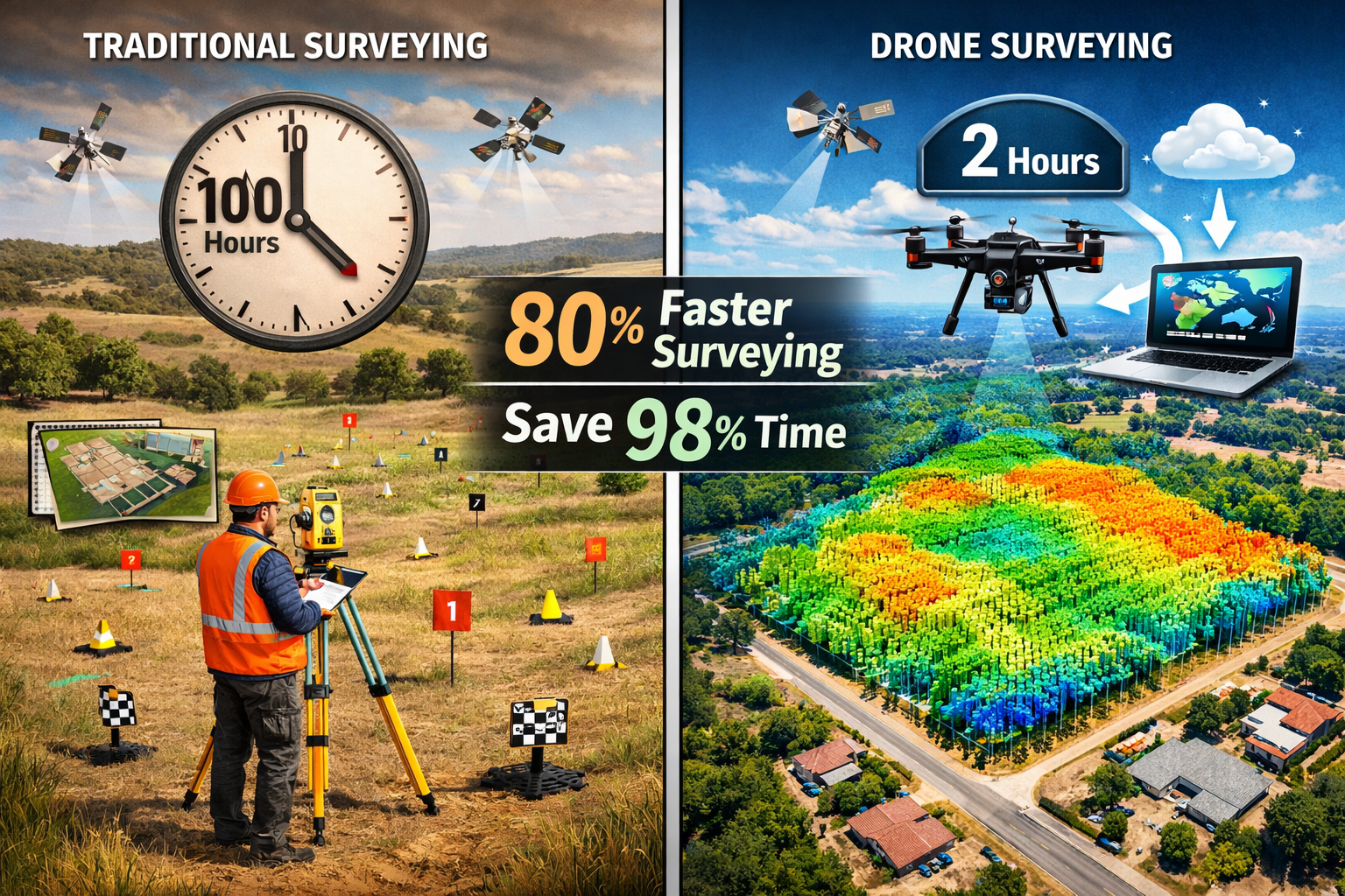
Traditional surveying methods required teams of professionals spending days or weeks on-site with total stations and GPS equipment. Today's autonomous systems complete the same work in hours while achieving centimeter-level accuracy through integrated RTK/PPK GNSS systems, LiDAR scanners, and AI-driven predictive modeling.[1][2] The shift from manual piloting to fully autonomous operations has eliminated the need for constant site visits, reduced project costs dramatically, and opened new possibilities for surveying previously inaccessible or hazardous terrain.
Key Takeaways
✅ Autonomous drones now integrate multiple sensors (RTK/PPK GNSS, LiDAR, RGB, multispectral, thermal) in single platforms, delivering survey-grade accuracy matching traditional ground-based methods
✅ Predictive modeling eliminates manual intervention by automatically planning flight paths and adjusting altitude, angle, and sensor selection in real-time for optimal data capture
✅ Time efficiency gains are dramatic: a single drone mission surveys hundreds of acres in hours, reducing a 12-acre property survey from 100 hours to just 2 hours
✅ AI-driven processing automates data analysis that previously took days or weeks, including feature extraction, change detection, and orthomosaic creation
✅ Regulatory frameworks now support BVLOS operations (Beyond Visual Line of Sight), enabling continuous infrastructure monitoring with drone-in-a-box systems requiring no on-site pilots
Understanding Multi-Sensor Integration in Autonomous Surveying Systems
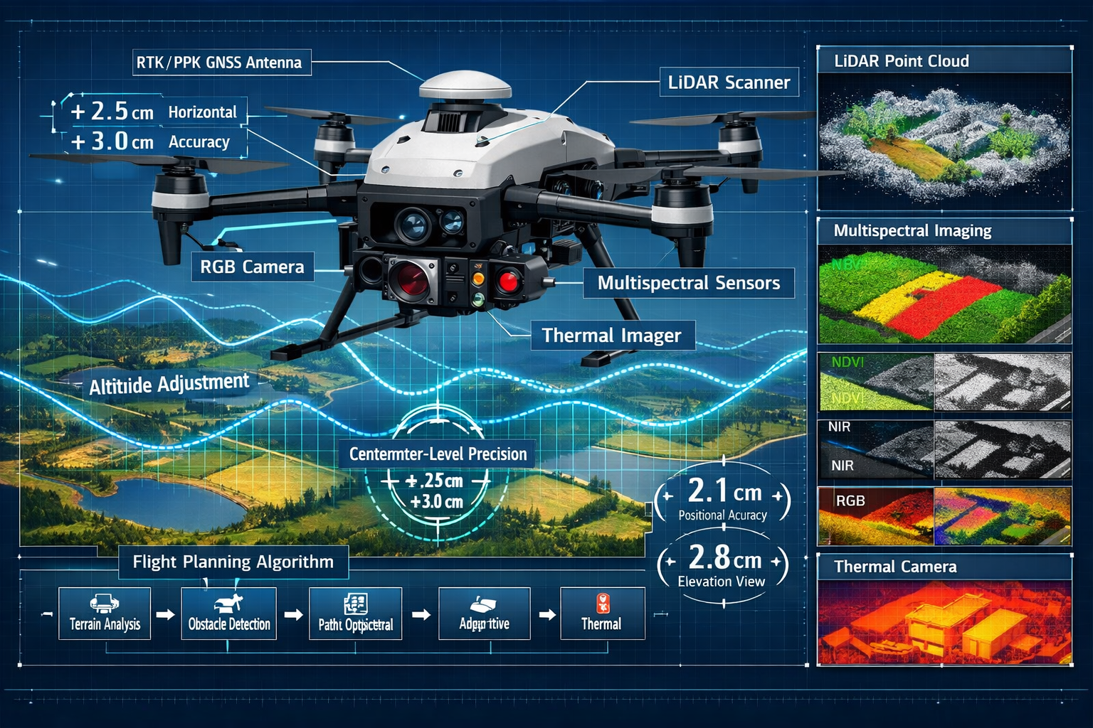
The foundation of Autonomous Drones in Land Surveying: Capturing Large-Scale Properties with Multi-Sensor Precision lies in sophisticated sensor fusion technology. Modern autonomous platforms combine multiple data collection systems that work simultaneously to capture comprehensive geospatial information.[1][2]
The Core Sensor Array
RTK/PPK GNSS Systems form the positioning backbone of autonomous surveying drones. Real-Time Kinematic (RTK) and Post-Processed Kinematic (PPK) systems achieve centimeter-level accuracy by correcting GPS signals using ground-based reference stations or satellite correction services.[2][3] This precision level meets professional surveying standards previously only achievable through traditional ground-based equipment.
LiDAR (Light Detection and Ranging) has reached mainstream adoption in 2026 as the standard method for topographic surveys, forestry mapping, utility corridor analysis, and mining operations.[3] Modern LiDAR-enabled UAVs feature:
- Faster pulse repetition rates enabling denser point clouds
- Improved IMU (Inertial Measurement Unit) integration for better motion compensation
- Enhanced penetration capabilities for accurate data collection under dense canopies
- Multi-return processing distinguishing ground surface from vegetation
High-Resolution RGB Cameras capture detailed visual imagery for orthomosaic creation, enabling professionals to generate accurate 2D maps with photographic detail. These cameras work in concert with other sensors to provide visual context for numerical data.
Multispectral and Thermal Sensors expand surveying capabilities beyond visible light. Multispectral imaging analyzes crop health, vegetation stress, and land use patterns—critical for agricultural applications. Thermal sensors detect temperature variations useful for infrastructure inspection, moisture detection, and environmental monitoring.
How Sensor Fusion Delivers Superior Results
The true power emerges when these sensors operate simultaneously. A single autonomous flight captures:
- Precise positioning data (RTK/PPK GNSS)
- 3D terrain models (LiDAR point clouds)
- Visual documentation (RGB imagery)
- Vegetation health metrics (multispectral analysis)
- Temperature mapping (thermal imaging)
This integrated approach eliminates the need for multiple site visits with different equipment, dramatically reducing project timelines and costs. For professionals conducting topographic surveys, this multi-sensor capability provides comprehensive data in a fraction of the traditional time.
Reduced Ground Control Point Dependency
One of the most significant advancements in 2026 involves dramatically reduced reliance on ground control points (GCPs).[3] Traditional photogrammetry required surveyors to establish numerous physical markers across the survey area to ensure accuracy. RTK/PPK-equipped autonomous drones now achieve comparable accuracy with significantly fewer GCPs—sometimes requiring none at all for certain applications.
This breakthrough particularly impacts:
- Remote locations where establishing GCPs is difficult or dangerous
- Linear infrastructure projects (pipelines, transmission lines, roads) spanning vast distances
- Time-sensitive surveys requiring rapid deployment
- Repeat monitoring applications where permanent reference points aren't practical
Predictive Modeling and Autonomous Flight Planning Revolution
The defining characteristic separating 2026's autonomous systems from earlier drone technology is intelligent, self-adjusting flight planning. Modern platforms use predictive modeling to automatically plan optimal flight paths while adapting in real-time to achieve the best possible data quality.[1][2]
How Predictive Flight Planning Works
Autonomous surveying drones analyze multiple variables before and during flight:
Pre-Flight Analysis includes:
- Terrain modeling from existing elevation data
- Vegetation density assessment from satellite imagery
- Weather forecasting for optimal lighting and wind conditions
- Regulatory airspace checking for compliance
- Battery life calculation based on distance, altitude changes, and sensor power requirements
Real-Time Adaptive Capabilities enable the drone to:
- Adjust altitude automatically to maintain consistent ground sampling distance over varying terrain
- Modify camera angles to ensure proper overlap for photogrammetry processing
- Switch sensor modes based on detected conditions (e.g., activating LiDAR in heavily vegetated areas)
- Reroute around obstacles detected by onboard sensors
- Optimize flight speed balancing coverage efficiency with image quality
This intelligent automation eliminates the trial-and-error approach that plagued earlier drone surveying, where pilots often needed multiple flights to achieve desired results.
Obstacle Avoidance and Safety Systems
Self-flying UAVs incorporate advanced obstacle detection and avoidance systems that operate independently of human intervention.[2] These safety features include:
- Forward, backward, and downward-facing sensors creating a 360-degree awareness bubble
- AI-powered object recognition distinguishing between temporary obstacles (birds, debris) and permanent structures
- Automatic altitude adjustment when approaching terrain features, buildings, or vegetation
- Emergency return-to-home protocols triggered by low battery, signal loss, or weather changes
- Geofencing compliance preventing flight into restricted airspace
These autonomous safety capabilities make drone surveying viable in complex environments where manual piloting would be risky or impossible. Construction sites, mining operations, and urban areas all benefit from this enhanced safety profile.
The Elimination of Site Visits
Perhaps the most transformative aspect of Autonomous Drones in Land Surveying: Capturing Large-Scale Properties with Multi-Sensor Precision is the dramatic reduction in required site visits.[1] Traditional surveying demanded:
- Initial site reconnaissance
- Ground control point establishment
- Multiple survey sessions for different data types
- Return visits for quality verification
- Additional trips for supplementary data
Autonomous systems now enable:
- Remote mission planning using existing maps and satellite imagery
- Single-visit data collection capturing all required information simultaneously
- Automated quality checking during flight with immediate alerts for data gaps
- Cloud-based processing eliminating the need for on-site data verification
For large-scale agricultural operations spanning thousands of acres, this shift means a single autonomous drone deployment can replace weeks of traditional surveying work. Development projects benefit similarly, with commercial property surveyors now able to assess multiple sites in a single day.
Time Efficiency and Accuracy: Transforming Large-Scale Property Surveying
The practical impact of autonomous drone technology becomes most apparent when examining time efficiency gains and accuracy improvements for large-scale properties.[1][7]
Quantifying the Speed Revolution
Industry data reveals dramatic time savings:
- A 12-acre property that traditionally required 100 hours of surveying work can now be completed in just 2 hours with autonomous drones[1]
- Hundreds of acres can be surveyed in a single day with modern systems
- Data processing time has decreased from weeks to hours through AI-driven automation[3]
These efficiency gains translate directly to cost savings. Consider a typical development project requiring topographic surveying, boundary verification, and volumetric analysis. Traditional methods might involve:
- 3-5 days of field work with a 2-3 person crew
- 1-2 weeks of data processing and CAD drafting
- Additional time for quality control and revision cycles
The same project with autonomous drone surveying requires:
- 2-4 hours of autonomous flight time
- Automated cloud processing delivering preliminary results within hours
- AI-assisted feature extraction reducing manual drafting by 70-80%
Accuracy Matching Survey-Grade Standards
Speed means nothing without accuracy. Modern autonomous systems achieve centimeter-level precision that meets or exceeds professional surveying standards.[2][3] This accuracy stems from:
RTK/PPK Positioning: Real-time or post-processed kinematic corrections deliver horizontal accuracy of ±1-2 cm and vertical accuracy of ±2-3 cm—comparable to traditional total station measurements.
High-Density Point Clouds: LiDAR systems capture millions of points per second, creating detailed 3D models with point spacing of 5-10 cm or better. This density reveals terrain features invisible to traditional survey methods.
Automated Quality Control: AI algorithms analyze captured data in real-time, identifying:
- Coverage gaps requiring additional passes
- Areas with insufficient overlap for photogrammetry
- Point cloud density variations
- Georeferencing accuracy issues
Deliverable Outputs meeting professional standards include:
| Output Type | Typical Accuracy | Common Applications |
|---|---|---|
| Orthomosaic Maps | 1-3 cm horizontal | Site planning, boundary verification |
| Digital Elevation Models (DEM) | 2-5 cm vertical | Grading design, drainage analysis |
| Digital Surface Models (DSM) | 2-5 cm vertical | Volumetric calculations, 3D modeling |
| Contour Maps | 5-10 cm intervals | Topographic analysis, civil engineering |
| 3D Point Clouds | 1-3 cm point spacing | As-built documentation, BIM integration |
These deliverables integrate seamlessly with CAD software, GIS platforms, and Building Information Modeling (BIM) systems used by engineers, architects, and planners.
Real-World Application: Agriculture and Development
Agricultural Applications demonstrate the transformative potential of autonomous surveying:
🌾 Precision Agriculture Mapping: Autonomous drones equipped with multispectral sensors create detailed crop health maps showing NDVI (Normalized Difference Vegetation Index) values across entire fields. Farmers use this data to optimize irrigation, fertilizer application, and pest management—increasing yields while reducing input costs.
🌾 Drainage and Irrigation Planning: High-accuracy elevation models reveal subtle terrain variations affecting water flow. Engineers design more efficient drainage systems and irrigation networks based on this detailed topographic data.
🌾 Land Parcel Documentation: Large agricultural properties require periodic boundary verification and acreage calculation for legal compliance, property transactions, and subsidy programs. Autonomous drones complete these surveys faster and more accurately than traditional methods.
Development Project Applications showcase efficiency gains:
🏗️ Site Analysis and Due Diligence: Developers evaluating potential properties use autonomous drone surveys to assess topography, identify constraints, and estimate earthwork requirements—all before committing to purchase. This approach mirrors the importance of conducting thorough property surveys before major investments.
🏗️ Construction Progress Monitoring: Autonomous systems deployed weekly or monthly track earthwork progress, verify grading accuracy, and calculate material volumes. This continuous monitoring identifies issues early, preventing costly corrections later.
🏗️ As-Built Documentation: Upon project completion, autonomous surveys create comprehensive as-built records including site topography, building positions, utility locations, and landscape features—essential for facility management and future modifications.
AI-Driven Data Processing: From Raw Data to Actionable Intelligence
The biggest transformative development in 2026 isn't the drones themselves—it's the AI-powered software processing the data they collect.[3] Automated analysis now handles tasks that previously consumed days or weeks of professional time.
Automated Feature Extraction
Modern processing platforms use machine learning algorithms trained on millions of survey images to automatically identify and extract:
Infrastructure Elements:
- Roads, driveways, and parking areas
- Buildings and structures with precise footprints
- Utility poles, transmission lines, and substations
- Fencing, walls, and property boundaries
- Drainage features, culverts, and retention ponds
Natural Features:
- Tree locations with height and canopy measurements
- Vegetation classification by type
- Water bodies with shoreline delineation
- Topographic features (ridges, valleys, slopes)
- Erosion patterns and soil conditions
This automated extraction eliminates the tedious manual digitizing that once occupied surveyors for hours. What previously required a skilled CAD technician 2-3 days now completes in 20-30 minutes of automated processing.
Change Detection and Monitoring
For projects requiring periodic monitoring—construction sites, mining operations, environmental compliance—AI-driven change detection automatically identifies differences between survey dates:
- Volumetric changes calculating cut/fill quantities with precision
- Structural changes detecting new buildings, demolitions, or modifications
- Vegetation changes tracking growth, clearing, or encroachment
- Erosion monitoring identifying soil loss or sediment accumulation
- Compliance verification ensuring work matches approved plans
These capabilities enable proactive project management. Construction managers receive automated alerts when earthwork deviates from design specifications. Environmental monitors detect unauthorized clearing or grading immediately rather than weeks later.
Cloud-Based Processing Integration
Cloud platforms have revolutionized surveying workflows in 2026.[2] Captured data automatically uploads via cellular connection during or immediately after flight. Cloud processing begins instantly, delivering:
- Preliminary orthomosaics within 1-2 hours
- 3D point clouds ready for viewing in 2-4 hours
- Fully processed deliverables including CAD files, elevation models, and reports within 4-8 hours
This rapid turnaround enables same-day decision-making. Developers can adjust plans based on survey findings without waiting days for results. Agricultural consultants provide immediate recommendations based on current crop conditions.
Collaborative Access means stakeholders view results simultaneously from any location:
- Project managers review progress from the office
- Engineers analyze data from design studios
- Clients access interactive 3D models via web browsers
- Regulatory agencies verify compliance remotely
Integration with Professional Workflows
Automated processing doesn't replace professional judgment—it amplifies it. Surveyors now focus on:
- Quality review rather than manual data processing
- Analysis and interpretation rather than feature digitizing
- Client consultation rather than repetitive CAD work
- Complex problem-solving rather than routine measurements
This shift mirrors the evolution in other professional fields where automation handles routine tasks, freeing experts for higher-value work. Just as structural engineer reports require professional interpretation of data, autonomous drone surveys still need expert oversight—but the nature of that work has fundamentally changed.
Beyond Visual Line of Sight: BVLOS Operations and Regulatory Maturity
Regulatory frameworks governing drone operations have matured significantly by 2026, with Beyond Visual Line of Sight (BVLOS) operations now approved for commercial surveying applications.[3] This regulatory evolution unlocks autonomous surveying's full potential.
Understanding BVLOS Operations
Traditional drone regulations required pilots to maintain visual contact with their aircraft at all times—a restriction limiting survey range to approximately 1-2 kilometers. BVLOS approval permits:
- Extended range operations surveying linear infrastructure (pipelines, transmission lines, railways) spanning dozens of kilometers
- Automated monitoring missions where drones operate on scheduled flights without human presence
- Drone-in-a-box systems that launch, fly, capture data, and return to charging stations autonomously
- Multi-drone coordination with several aircraft surveying different areas simultaneously
Drone-in-a-Box Systems
Autonomous drone-in-a-box platforms represent the ultimate expression of hands-off surveying.[3] These systems consist of:
- Weather-resistant housing protecting the drone between missions
- Automated launch and landing mechanisms requiring no human intervention
- Charging infrastructure maintaining battery readiness
- Cellular or satellite connectivity for remote mission planning and data transfer
- Environmental sensors monitoring conditions and postponing flights during adverse weather
Applications include:
🔄 Infrastructure Monitoring: Utility companies deploy drone-in-a-box systems along transmission corridors, automatically inspecting towers, lines, and right-of-way vegetation on weekly schedules. Anomalies trigger alerts for human review.
🔄 Construction Site Progress: Developers install permanent systems at large projects, capturing daily or weekly surveys documenting progress, verifying contractor work, and updating stakeholders automatically.
🔄 Agricultural Monitoring: Large farms use scheduled flights throughout growing seasons, tracking crop development, identifying stress areas, and optimizing management practices based on continuous data.
🔄 Environmental Compliance: Mining operations and development projects maintain automated monitoring proving compliance with environmental permits, detecting erosion, and documenting restoration progress.
Remote ID and Airspace Integration
Remote ID technology—now fully integrated into commercial drones—broadcasts identification and location information, enabling:
- Air traffic management integration with manned aircraft receiving alerts about drone operations
- Regulatory compliance verification with authorities able to identify and track commercial flights
- Conflict prevention through automated coordination between multiple drone operators
- Enhanced public safety by enabling rapid identification of unauthorized flights
This technological infrastructure creates the foundation for routine BVLOS operations without compromising airspace safety.
Regulatory Compliance Considerations
Despite regulatory maturity, commercial operators must still navigate:
Licensing Requirements: Pilots operating autonomous systems need appropriate certifications, though the nature of required skills has shifted from manual flight proficiency toward mission planning and data analysis.
Insurance and Liability: Professional surveying operations require comprehensive insurance covering equipment loss, third-party damage, and professional liability. Autonomous operations may face different risk assessments than manual piloting.
Client Expectations: Many clients—particularly in regulated industries or government projects—require specific certifications, quality assurance protocols, and documentation standards regardless of automation level.
Data Security: Surveying often captures sensitive information about property boundaries, infrastructure vulnerabilities, or proprietary operations. Secure data handling and storage protocols are essential, especially with cloud-based processing.
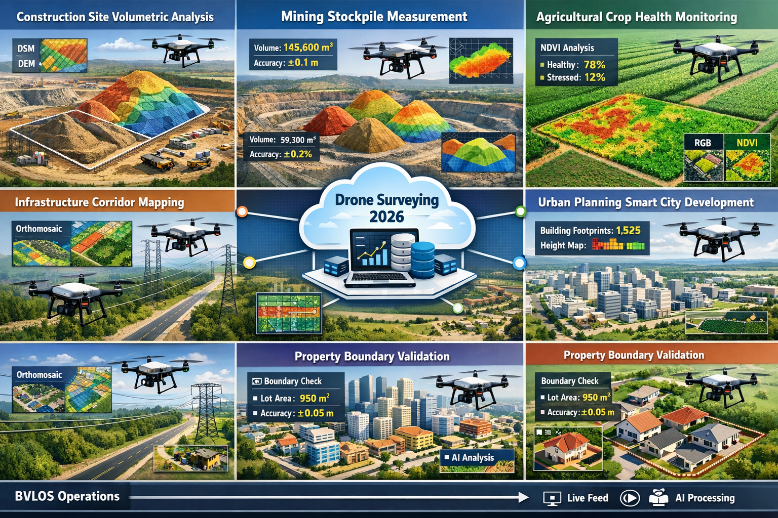
Industry Applications: From Agriculture to Urban Development
Autonomous Drones in Land Surveying: Capturing Large-Scale Properties with Multi-Sensor Precision serves diverse industries in 2026, each leveraging the technology's unique advantages.[2][5]
Construction and Development
Construction industry adoption has been particularly rapid, with autonomous drones now standard on major projects:
Site Preparation and Grading: Contractors use weekly autonomous surveys to verify earthwork quantities, ensuring subcontractors meet specifications before payment. Automated cut/fill analysis detects errors early, preventing expensive corrections.
Progress Documentation: Monthly surveys create comprehensive visual and dimensional records of construction progress. These records protect contractors from disputes, verify schedule compliance, and provide stakeholders with transparent project status.
Volumetric Calculations: Stockpile measurement for materials like aggregate, soil, and demolition debris achieves accuracy within 1-2%, replacing manual measurements or less accurate estimation methods.
Safety and Inspection: Autonomous drones inspect hard-to-reach areas—roofs, tall structures, excavations—without exposing workers to fall hazards or confined spaces.
Mining and Aggregates
Mining operations have embraced autonomous surveying for:
Stockpile Inventory: Monthly or weekly surveys calculate precise volumes of ore, overburden, and processed materials. This data feeds directly into production reporting and financial accounting systems.
Pit Progression Monitoring: Regular surveys track excavation progress, verify compliance with mine plans, and identify geotechnical hazards. Change detection algorithms automatically flag unexpected slope movements or instability.
Reclamation Documentation: Environmental regulations require detailed documentation of mine reclamation. Autonomous surveys prove compliance with restoration plans, measuring revegetation success and topographic restoration.
Agriculture and Land Management
Agricultural applications showcase autonomous surveying's versatility:
Crop Health Monitoring: Multispectral imaging identifies stressed areas requiring attention before visible symptoms appear. Farmers target interventions precisely, reducing chemical use while improving yields.
Drainage and Irrigation Design: High-accuracy elevation models reveal subtle terrain variations affecting water management. Engineers design more efficient systems reducing water consumption and preventing crop damage from poor drainage.
Property Boundary Verification: Large agricultural properties require periodic boundary surveys for legal compliance, lease agreements, and property transactions. Autonomous systems complete these surveys faster and more affordably than traditional methods, similar to how homebuyers benefit from professional surveys.
Yield Prediction: Vegetation indices from multispectral imagery correlate with crop yields, enabling accurate harvest predictions that inform marketing, storage, and logistics planning.
Infrastructure and Utilities
Linear infrastructure presents unique surveying challenges that autonomous systems address effectively:
Corridor Mapping: Pipelines, transmission lines, railways, and highways spanning vast distances require periodic surveys for maintenance planning, encroachment detection, and regulatory compliance. BVLOS-capable autonomous drones survey these corridors efficiently.
Asset Inventory: Automated feature extraction identifies and catalogs infrastructure assets—poles, towers, valves, switches—creating comprehensive databases for maintenance management.
Vegetation Management: Utility companies monitor vegetation encroachment on rights-of-way, identifying trees requiring trimming before they threaten service reliability.
Condition Assessment: Thermal imaging and high-resolution photography detect infrastructure defects—insulator damage, corrosion, leaks—enabling proactive maintenance preventing failures.
Urban Planning and Smart Cities
Municipal governments and urban planners leverage autonomous surveying for:
3D City Modeling: Comprehensive surveys create detailed 3D models supporting planning, zoning decisions, and public engagement. These models integrate with GIS systems and urban analytics platforms.
Infrastructure Planning: Accurate elevation models inform stormwater management, transportation planning, and utility network design. Planners identify optimal routes and anticipate challenges before construction begins.
Change Detection: Regular surveys track urban development, verify permit compliance, and detect unauthorized construction. Automated change detection flags discrepancies for enforcement action.
Environmental Monitoring: Urban heat island mapping using thermal sensors, vegetation health assessment, and impervious surface calculation support sustainability initiatives and climate adaptation planning.
Drone as a Service (DaaS) Business Models
The Drone as a Service industry has expanded significantly, with specialized providers offering turnkey surveying solutions.[5] Companies like ZenaTech integrate drone-based workflows into services for national homebuilders, handling:
- Topographic surveys meeting engineering specifications
- Plot plans for permit applications
- Boundary validation ensuring compliance with property descriptions
- Zoning compliance verification documenting setbacks and restrictions
- Jurisdiction-specific formatting delivering data in required formats
This DaaS model allows organizations to access cutting-edge autonomous surveying technology without capital investment in equipment, software, or specialized personnel. Providers handle:
- Equipment procurement and maintenance
- Pilot licensing and training
- Regulatory compliance
- Data processing and deliverable creation
- Quality assurance and professional certification
For many businesses, this outsourced approach proves more cost-effective than developing internal capabilities, particularly for occasional or seasonal surveying needs.
Future Developments and Emerging Trends
While 2026's autonomous surveying technology already seems revolutionary, several emerging trends promise further advancement:
Enhanced Sensor Miniaturization
Ongoing sensor miniaturization enables smaller, lighter drones carrying full survey-grade sensor suites. This trend improves:
- Flight endurance with reduced weight allowing larger batteries
- Maneuverability in confined spaces or complex environments
- Portability making deployment easier in remote locations
- Cost accessibility as smaller platforms reduce equipment investment
Swarm Surveying Coordination
Multi-drone coordination allows several autonomous aircraft to survey simultaneously, dividing large areas for parallel coverage. Swarm systems offer:
- Exponentially faster survey completion
- Redundancy improving reliability
- Specialized sensor allocation (one drone with LiDAR, another with multispectral, etc.)
- Continuous coverage with aircraft rotating for battery changes
Real-Time Processing Capabilities
Edge computing advances enable on-board data processing during flight, delivering:
- Instant quality verification with automated gap-filling
- Real-time deliverable generation for time-critical applications
- Reduced data transmission requirements in bandwidth-limited areas
- Enhanced autonomous decision-making based on processed data rather than raw sensor inputs
Integration with Other Technologies
Autonomous surveying increasingly integrates with complementary technologies:
Artificial Intelligence: Machine learning algorithms continuously improve feature recognition, anomaly detection, and data quality assessment.
Digital Twins: Survey data feeds directly into digital twin platforms creating living models of infrastructure, properties, or entire cities that update automatically with each survey mission.
Augmented Reality: Field personnel use AR devices overlaying survey data onto real-world views, improving construction layout, utility location, and inspection workflows.
Blockchain: Immutable records of survey data, timestamps, and processing steps create verifiable chains of custody for legal and regulatory applications.
Regulatory Evolution
Regulatory frameworks continue evolving to accommodate autonomous technology:
- Expanded BVLOS permissions with simplified approval processes
- Urban air mobility integration coordinating surveying drones with emerging air taxi services
- International harmonization reducing barriers to cross-border operations
- Performance-based regulations focusing on outcomes rather than prescriptive operational requirements
Selecting and Implementing Autonomous Surveying Solutions
Organizations considering autonomous drone surveying face important implementation decisions:
Technology Selection Criteria
Accuracy Requirements: Different applications demand different precision levels. Construction and engineering projects typically require centimeter-level accuracy necessitating RTK/PPK systems. Agricultural monitoring may accept meter-level accuracy from standard GPS.
Coverage Area: Property size influences platform selection. Small sites (under 50 acres) work well with compact systems. Large properties (hundreds or thousands of acres) benefit from longer-endurance platforms or drone-in-a-box deployments.
Sensor Needs: Required deliverables determine sensor selection:
- RGB cameras for orthomosaics and visual documentation
- LiDAR for terrain modeling under vegetation
- Multispectral for agricultural applications
- Thermal for infrastructure inspection
Processing Requirements: Consider whether cloud processing meets needs or if on-premise solutions are necessary for data security, internet connectivity limitations, or processing volume.
Regulatory Environment: Ensure selected systems meet local regulatory requirements for remote ID, weight limits, and operational restrictions.
Build vs. Buy vs. Service Decisions
In-House Capabilities: Organizations with frequent surveying needs may justify:
- Equipment purchase ($15,000-$150,000+ depending on capabilities)
- Staff training and certification
- Software licensing for processing and analysis
- Ongoing maintenance and upgrades
Outsourced Services: Occasional users often prefer engaging professional providers offering:
- No capital investment
- Access to latest technology
- Professional expertise and quality assurance
- Flexibility to scale services up or down
Hybrid Approaches: Some organizations maintain basic in-house capabilities for routine work while outsourcing complex or specialized projects requiring advanced sensors or expertise.
Implementation Best Practices
Start with Pilot Projects: Test autonomous surveying on non-critical projects before relying on it for high-stakes applications. This approach builds confidence, identifies workflow adjustments, and demonstrates value to stakeholders.
Invest in Training: Even highly automated systems require skilled operators understanding mission planning, data quality assessment, and deliverable interpretation. Professional training programs ensure staff maximize technology capabilities.
Establish Quality Assurance Protocols: Develop systematic processes for:
- Pre-flight mission planning and checklist completion
- In-flight monitoring and anomaly response
- Post-flight data quality verification
- Deliverable review and approval
Document Workflows: Create standard operating procedures documenting each step from project initiation through deliverable delivery. Documentation ensures consistency, facilitates training, and supports quality control.
Maintain Regulatory Compliance: Stay current with evolving regulations, maintain required certifications, and document compliance for client and regulatory requirements.
Overcoming Common Challenges
Despite significant advances, autonomous surveying still faces challenges:
Weather Limitations
Drones remain sensitive to weather conditions:
- Wind affects flight stability and image quality
- Rain damages equipment and prevents operation
- Extreme temperatures reduce battery performance
- Poor lighting (overcast, harsh shadows) degrades photogrammetry results
Mitigation strategies include:
- Flexible scheduling allowing weather delays
- Weather monitoring and forecasting integration
- Seasonal planning for optimal conditions
- Alternative methods (LiDAR) less affected by lighting
Data Volume Management
Modern sensors generate enormous data volumes:
- Single survey missions produce 10-100+ GB of raw data
- Processing requires substantial computing resources
- Storage and archival create ongoing costs
- Data transfer consumes bandwidth and time
Management approaches include:
- Cloud processing distributing computational load
- Automated data lifecycle management archiving or deleting obsolete datasets
- Selective processing focusing on areas of interest
- Compression and optimization reducing storage requirements
Skill Development and Workforce Adaptation
The shift from traditional surveying to autonomous drone operations requires workforce adaptation:
- Experienced surveyors need technology training
- Data processing skills become more important than field measurement techniques
- Understanding sensor capabilities and limitations replaces equipment operation proficiency
Successful transitions involve:
- Comprehensive training programs
- Gradual technology adoption allowing skill development
- Mentorship pairing experienced surveyors with technology specialists
- Recognition that professional judgment remains essential despite automation
Client Education and Expectations
Many clients remain unfamiliar with autonomous surveying capabilities and limitations:
- Unrealistic expectations about accuracy, speed, or deliverables
- Concerns about data quality compared to traditional methods
- Regulatory or contractual requirements specifying traditional approaches
Effective client management includes:
- Clear communication about capabilities and limitations
- Sample deliverables demonstrating quality
- Comparison data showing equivalence or superiority to traditional methods
- Education about regulatory acceptance and professional standards compliance
Conclusion
Autonomous Drones in Land Surveying: Capturing Large-Scale Properties with Multi-Sensor Precision represents a fundamental transformation in how professionals capture, process, and utilize geospatial data. The convergence of RTK/PPK positioning, multi-sensor integration, AI-driven processing, and predictive flight planning has created systems that survey hundreds of acres in hours while achieving centimeter-level accuracy—capabilities unimaginable just a few years ago.[1][2][3]
The practical benefits extend across industries. Agricultural operations optimize crop management through precise vegetation monitoring. Development projects reduce costs and timelines through efficient site analysis and progress tracking. Infrastructure managers maintain assets proactively using continuous automated monitoring. Urban planners make better decisions supported by comprehensive, current 3D data.
Perhaps most significantly, autonomous systems have democratized access to high-quality surveying data. What once required expensive specialized equipment and weeks of professional time now completes in hours at a fraction of the cost. This accessibility enables better decision-making across the property lifecycle—from initial site evaluation through development, construction, and ongoing management.
Actionable Next Steps
For property owners and developers considering autonomous surveying:
- Evaluate current surveying needs identifying applications where autonomous drones offer advantages in speed, cost, or data quality
- Request demonstrations from service providers showing actual deliverables and workflows
- Compare costs between traditional methods and autonomous alternatives for specific projects
- Start with pilot projects testing capabilities on non-critical applications before full adoption
For surveying professionals adapting to autonomous technology:
- Invest in training developing skills in mission planning, data processing, and automated workflow management
- Acquire appropriate equipment or establish service provider relationships matching client needs
- Develop quality assurance protocols ensuring autonomous deliverables meet professional standards
- Educate clients about capabilities, limitations, and appropriate applications
For organizations building internal capabilities:
- Assess requirements determining accuracy needs, coverage areas, sensor requirements, and usage frequency
- Evaluate build vs. buy vs. service options considering capital costs, ongoing expenses, and strategic priorities
- Plan implementation including equipment selection, staff training, workflow development, and quality assurance
- Start small and scale proving value with limited deployments before major investments
The autonomous surveying revolution is here. Organizations embracing this technology gain competitive advantages through faster project delivery, reduced costs, and enhanced data quality. Those hesitating risk falling behind as autonomous systems become industry standard. The question is no longer whether to adopt autonomous drone surveying, but how quickly to implement it effectively.
Just as professional property surveys remain essential for informed real estate decisions, autonomous drone surveying has become indispensable for modern land development, agricultural management, and infrastructure maintenance. The technology continues evolving rapidly, but 2026's capabilities already deliver transformative value for those ready to embrace the future of geospatial data collection.
References
[1] Future Land Surveying 2026 – https://haller-blanchard.com/future-land-surveying-2026/
[2] Self Flying Uavs For Survey Mapping Are Redefining Aerial Intelligence – https://www.dronitech.com/self-flying-uavs-for-survey-mapping-are-redefining-aerial-intelligence/
[3] How Drones Are Transforming Surveying Mapping And Inspection In 2026 – https://www.uavsphere.com/post/how-drones-are-transforming-surveying-mapping-and-inspection-in-2026
[5] Zenatech S Drone As A Service Expands Builder Services Capability Delivering Drone Driven Speed And Precision To Surveying For Homebuilders – https://markets.businessinsider.com/news/currencies/zenatech-s-drone-as-a-service-expands-builder-services-capability-delivering-drone-driven-speed-and-precision-to-surveying-for-homebuilders-1035808701
[7] Drones In Construction – https://uavcoach.com/drones-in-construction/