
The land surveying industry stands at a pivotal moment in 2026, where traditional methods are rapidly giving way to cutting-edge technologies that promise unprecedented accuracy, efficiency, and cost savings. The Future of Land Surveying Technology: 2026 Trends in Mobile 3D Mapping and GNSS RTK Systems represents a fundamental shift in how professionals capture, process, and deliver spatial data across diverse environments. From compact mobile mapping devices that fit in a backpack to satellite-guided positioning systems achieving centimeter-level precision, these innovations are reshaping project timelines and budgets in ways that seemed impossible just a few years ago.
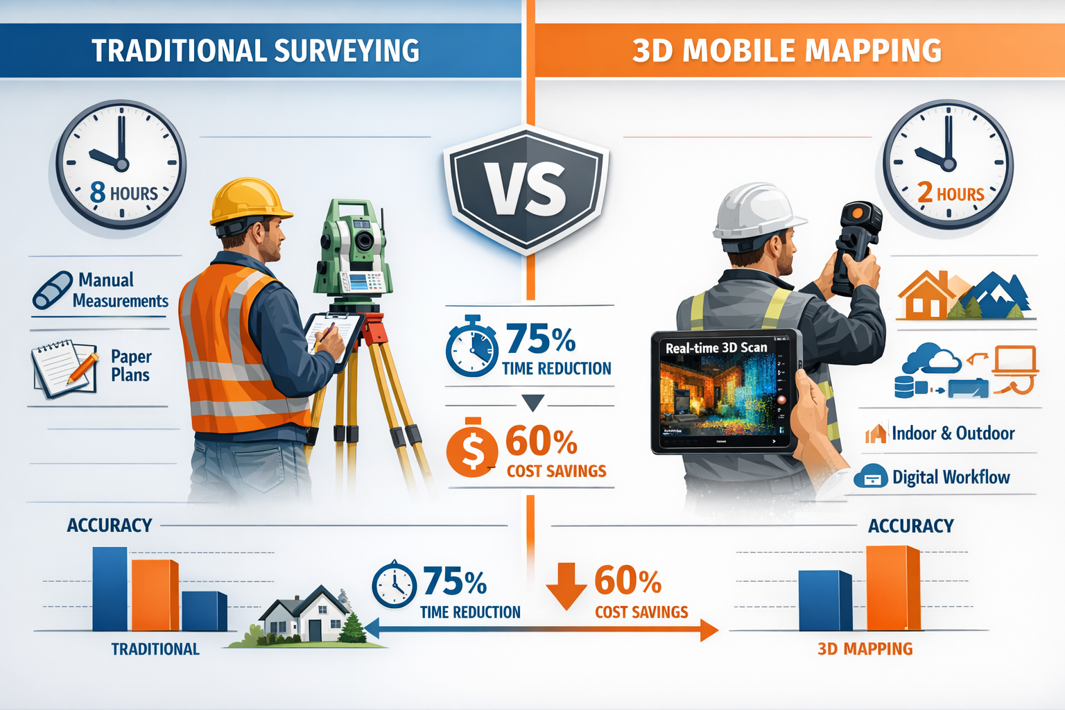
Modern surveying professionals face mounting pressure to deliver faster results without compromising accuracy. Traditional surveying methods, while proven and reliable, often require extensive setup time, multiple site visits, and labor-intensive data processing. In contrast, today's mobile 3D mapping systems and GNSS RTK (Global Navigation Satellite System Real-Time Kinematic) technologies enable surveyors to capture comprehensive spatial data in a fraction of the time, dramatically reducing project costs while improving data quality and detail.
Key Takeaways
- 📊 Mobile 3D mapping systems reduce survey time by up to 75% compared to traditional methods while capturing more detailed spatial data for both indoor and outdoor environments
- 🛰️ GNSS RTK technology delivers centimeter-level accuracy in real-time, enabling faster field decisions and eliminating the need for time-consuming post-processing in many applications
- 🤖 AI-powered automation is transforming data processing workflows by automatically classifying terrain features, identifying survey markers, and flagging potential anomalies before project completion
- 🚁 Integrated drone systems now combine LiDAR, photogrammetry, multispectral, and thermal sensors in synchronized arrays, capturing comprehensive datasets in single flights
- 💰 Cost reductions of 40-60% are achievable through reduced field time, smaller crew requirements, and streamlined data processing pipelines when adopting modern surveying technologies
Understanding The Future of Land Surveying Technology: 2026 Trends in Mobile 3D Mapping and GNSS RTK Systems
The surveying profession has evolved dramatically over the past decade, but 2026 marks a particularly significant milestone. The convergence of several technological advancements—mobile computing power, sensor miniaturization, satellite positioning improvements, and artificial intelligence—has created an ecosystem where surveying professionals can accomplish in hours what previously took days or weeks.
What Makes 2026 Different for Surveying Technology?
The year 2026 represents a maturation point for several emerging technologies that have been developing over the past five years. Unlike earlier experimental phases, these systems now offer production-ready reliability with proven track records across thousands of real-world projects. Surveyors no longer need to choose between innovation and dependability; modern systems deliver both simultaneously.
Several factors distinguish 2026's technological landscape:
- Seamless integration between different surveying technologies (mobile mapping, GNSS, drones, and AI processing)
- Cloud-based workflows enabling real-time collaboration and instant data sharing with stakeholders
- Affordable entry points making advanced technology accessible to small and mid-sized surveying firms
- Standardized data formats ensuring compatibility across different software platforms and client requirements
- Regulatory acceptance of digital surveying methods by government agencies and professional organizations
The Shift from Traditional to Digital Surveying Methods
Traditional land surveying relies heavily on total stations, theodolites, and manual measurement techniques that have served the profession well for decades. These methods require establishing control points, setting up equipment at multiple stations, and carefully measuring angles and distances to create accurate survey maps. While effective, this approach demands significant time investment and specialized training.
Modern digital surveying methods fundamentally change this workflow. Instead of measuring individual points sequentially, mobile 3D mapping systems capture millions of data points per second as surveyors simply walk through or drive around a site[1]. This density of spatial information provides far more comprehensive documentation than traditional methods, revealing details that might otherwise go unnoticed.
The efficiency gains are substantial. A traditional boundary survey of a 5-acre commercial property might require 2-3 days of field work with a two-person crew. Using mobile 3D mapping combined with GNSS RTK positioning, the same survey can often be completed in 4-6 hours with a single operator, representing a time reduction of approximately 75%[1].
Mobile 3D Mapping: Revolutionizing Indoor and Outdoor Surveys
Mobile mapping systems have emerged as one of the most transformative technologies in land surveying, offering capabilities that bridge the gap between traditional surveying and modern spatial data capture. These portable systems create detailed 3D models from diverse indoor and outdoor environments without requiring bulky equipment or extensive setup procedures[1].
How Mobile 3D Mapping Systems Work
At their core, mobile 3D mapping systems integrate several technologies into a single portable unit:
LiDAR (Light Detection and Ranging) sensors emit laser pulses that bounce off surrounding surfaces, measuring the time it takes for light to return. This process happens thousands or millions of times per second, creating dense "point clouds" that represent the physical geometry of the environment.
Inertial Measurement Units (IMUs) track the device's orientation and movement through space, ensuring accurate positioning of each laser measurement even as the operator walks or drives.
GNSS receivers provide absolute positioning data when satellite signals are available (outdoor environments), while SLAM (Simultaneous Localization and Mapping) algorithms enable accurate mapping in GPS-denied environments like building interiors.
High-resolution cameras capture photographic imagery that can be overlaid onto the 3D point cloud data, providing visual context and enabling photorealistic 3D models.
Modern systems integrate these components into packages small enough to carry in a backpack or mount on a vehicle, making them practical for a wide range of surveying applications.
Comparing Mobile 3D Mapping vs. Traditional Surveying Methods
The differences between mobile mapping and traditional surveying extend far beyond equipment size. Understanding these distinctions helps surveying professionals choose the right approach for each project.
| Aspect | Traditional Surveying | Mobile 3D Mapping |
|---|---|---|
| Setup Time | 30-60 minutes per station | 5-10 minutes total |
| Data Capture Rate | 100-500 points per hour | 300,000+ points per second |
| Crew Size | 2-3 people typically | 1 person sufficient |
| Indoor Capability | Limited, requires line of sight | Excellent, works without GPS |
| Weather Sensitivity | High (rain, wind affect accuracy) | Moderate (most systems weather-resistant) |
| Data Processing | Manual calculations, CAD drafting | Automated point cloud processing |
| Typical 5-Acre Survey Time | 16-24 hours field work | 4-6 hours field work |
| Cost per Project | Baseline | 40-60% reduction |
These efficiency improvements translate directly to project economics. For example, a recent highway corridor survey covering 15 miles traditionally would have required a crew of three surveyors working for approximately two weeks. Using a vehicle-mounted mobile mapping system, the same project was completed in three days with a two-person crew, reducing labor costs by approximately 65% while capturing significantly more detailed data[2].
Real Project Examples: Efficiency Gains and Cost Reductions
Commercial Building Documentation Project
A surveying firm was contracted to create as-built documentation for a 150,000 square foot warehouse facility undergoing renovation. Traditional methods would have involved:
- 5-7 days of field measurements with a two-person crew
- Extensive manual note-taking and sketching
- 3-4 days of CAD drafting to produce deliverable drawings
- Total project cost: approximately $18,000
Using a handheld mobile 3D mapping system, the actual project timeline was:
- 6 hours of walking through the facility capturing data
- Automated point cloud processing overnight
- 1 day of CAD work extracting required measurements
- Total project cost: approximately $7,200
The 60% cost reduction came primarily from reduced field time and streamlined data processing. Additionally, the client received a complete 3D point cloud dataset they could reference for future planning, providing value beyond the original scope.
Topographic Survey for Site Development
A land development company needed topographic survey data for a 12-acre site with mixed terrain including wooded areas, open fields, and existing structures. Traditional surveying approach:
- 4-5 days of field work with total station and GPS rover
- Clearing sight lines through wooded areas
- Manual feature coding and note-taking
- 2-3 days of data processing and CAD drafting
- Project cost: approximately $22,000
Mobile mapping approach using backpack LiDAR system:
- 8 hours of walking the site perimeter and key features
- Drone flight with LiDAR for canopy-covered areas (2 hours)
- Automated terrain classification and feature extraction
- 1 day of quality control and deliverable preparation
- Project cost: approximately $9,500
The 57% cost savings resulted from dramatically reduced field time and automated data processing. The dense point cloud data also revealed subtle terrain variations that would have been missed with traditional spot measurements, improving the quality of the final civil engineering design.
Indoor Surveying Applications
Mobile 3D mapping truly shines in indoor environments where traditional surveying methods face significant challenges. GPS signals don't penetrate building structures, and establishing control networks inside complex facilities can be extremely time-consuming.
Modern mobile mapping systems use SLAM algorithms that don't rely on satellite positioning. Instead, they continuously analyze the surrounding environment, identifying distinctive features and using them to maintain accurate positioning as the operator moves through the space[1].
Common indoor applications include:
- Facility management documentation for hospitals, universities, and corporate campuses
- Historic building preservation capturing architectural details for restoration projects
- Industrial plant as-builts documenting complex piping, equipment, and structural systems
- Retail space planning providing accurate measurements for tenant improvements
- Building information modeling (BIM) creating 3D models for renovation and maintenance
The ability to capture comprehensive spatial data without disrupting building operations represents a significant advantage. A surveyor can document an active manufacturing facility during production hours, something nearly impossible with traditional methods requiring clear sight lines and stationary equipment setup.
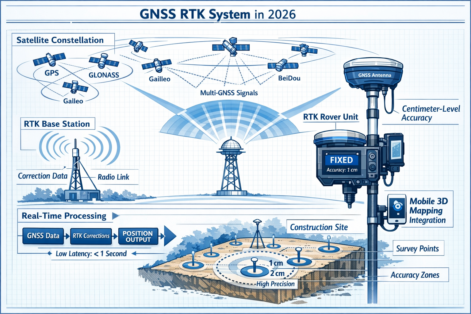
GNSS RTK Systems: Achieving Centimeter-Level Precision in Real-Time
While mobile 3D mapping excels at capturing detailed spatial information, GNSS RTK technology provides the absolute positioning accuracy that anchors survey data to real-world coordinates. Real-Time Kinematic positioning has become the backbone of modern surveying workflows in 2026, offering precision that rivals traditional methods while dramatically improving field efficiency.
Understanding GNSS RTK Technology
Standard GPS receivers, like those in smartphones, typically provide accuracy within 5-10 meters under good conditions. This level of precision works fine for navigation but falls far short of surveying requirements. GNSS RTK systems achieve centimeter-level accuracy through a sophisticated correction process[3].
The RTK system consists of two main components:
Base Station: A GNSS receiver positioned at a precisely known location (either a permanent reference station or a temporary setup on a surveyed point). The base station receives satellite signals and compares the measured positions with its known location, calculating correction values for various error sources.
Rover Unit: A mobile GNSS receiver carried by the surveyor. The rover receives both satellite signals and correction data from the base station (transmitted via radio or cellular connection). By applying these corrections in real-time, the rover can determine its position with centimeter-level accuracy.
This correction process happens continuously, providing instant positioning feedback as surveyors move through the field. There's no waiting for post-processing or returning to the office to discover positioning errors—surveyors know immediately whether their measurements meet accuracy requirements.
RTK vs. PPK: Choosing the Right Approach
While RTK (Real-Time Kinematic) dominates modern surveying workflows, PPK (Post-Processed Kinematic) positioning remains valuable for certain applications[1]. Understanding when to use each approach optimizes both accuracy and efficiency.
Real-Time Kinematic (RTK) Advantages:
- Immediate accuracy feedback in the field
- Ability to make decisions and adjust survey plans on-site
- No post-processing time required
- Ideal for stakeout and construction layout work
- Enables real-time quality control
Post-Processed Kinematic (PPK) Advantages:
- Works in areas with poor radio/cellular coverage
- Can achieve slightly better accuracy through longer processing
- Allows use of multiple base stations for improved reliability
- Better for aerial surveys where real-time communication is challenging
- Provides verification of RTK measurements for critical projects
Many modern surveying workflows use both methods simultaneously—collecting data with RTK for immediate feedback while also logging raw observations for PPK verification. This redundancy provides confidence in critical measurements while maintaining field efficiency.
Multi-Constellation GNSS: Beyond GPS
Early RTK systems relied exclusively on the U.S. GPS satellite constellation. In 2026, professional surveying equipment routinely tracks signals from four major global navigation satellite systems simultaneously:
- GPS (United States): 31 operational satellites
- GLONASS (Russia): 24 operational satellites
- Galileo (European Union): 30 operational satellites
- BeiDou (China): 35 operational satellites
This multi-constellation approach provides several critical advantages:
🛰️ Increased satellite visibility: More satellites mean better positioning geometry and faster initialization times, especially in challenging environments like urban canyons or partially wooded areas.
🛰️ Improved reliability: If signals from one constellation are blocked or degraded, the system continues operating using satellites from other constellations.
🛰️ Enhanced accuracy: More observations enable better error modeling and correction, pushing achievable accuracy from 2-3 cm down to 1 cm or better in optimal conditions.
🛰️ Faster convergence: RTK systems can establish centimeter-level accuracy in 10-30 seconds rather than the several minutes required with GPS-only systems.
Integration with Mobile Mapping Systems
The true power of modern surveying technology emerges when GNSS RTK systems integrate seamlessly with mobile 3D mapping devices. This combination provides both absolute positioning accuracy and comprehensive spatial detail.
Consider a corridor mapping project along a proposed utility route. A vehicle-mounted mobile mapping system equipped with RTK positioning can drive the route at normal traffic speeds while simultaneously:
- Capturing millions of LiDAR points per second documenting terrain, vegetation, and existing structures
- Recording high-resolution imagery of the corridor
- Maintaining centimeter-level positioning accuracy for all captured data
- Creating a georeferenced 3D model ready for engineering design
This integrated approach delivers results that would require weeks of traditional surveying in a matter of hours. The RTK positioning ensures that every point in the 3D model has accurate real-world coordinates, enabling direct use in design software without additional control survey work.
Practical Applications and Field Examples
Boundary Survey with RTK
A surveying firm needed to establish property boundaries for a 50-acre rural parcel with existing fence lines and scattered monuments. Using RTK-equipped rovers:
- Located and verified existing survey monuments with centimeter accuracy
- Traversed the entire boundary in 6 hours (vs. 2-3 days with traditional methods)
- Set new boundary markers with real-time confirmation of positioning accuracy
- Collected topographic data along the boundary simultaneously
- Delivered final survey within 24 hours of field work completion
The RTK system's real-time feedback allowed the surveyor to verify monument positions immediately, eliminating uncertainty and the need for return visits.
Construction Stakeout
A civil engineering project required staking hundreds of points for building foundations, utility lines, and grading control. Traditional stakeout methods involve:
- Calculating coordinates for each stake point
- Setting up total station at control points
- Measuring angles and distances to each stake location
- Time-consuming process requiring constant equipment moves
With RTK positioning:
- Surveyor loads stake coordinates into rover controller
- System provides real-time navigation to each point
- Displays distance and direction to target position
- Confirms when stake is positioned within tolerance (typically ±0.02 feet)
- Entire stakeout completed in 40% less time than traditional methods
The efficiency gains multiply on large projects with hundreds or thousands of stake points, often reducing costs by 50% or more while maintaining or improving accuracy.
AI and Automation: The Future of Land Surveying Technology's Processing Workflows
Perhaps the most transformative aspect of The Future of Land Surveying Technology: 2026 Trends in Mobile 3D Mapping and GNSS RTK Systems isn't the data capture hardware, but rather the artificial intelligence systems that process and analyze the massive datasets these tools generate. Machine learning algorithms are now directly embedded into core surveying workflows, fundamentally changing how surveyors interact with spatial data[2].
Automated Feature Classification and Extraction
Traditional surveying required field crews to manually identify and code every feature they measured—marking points as "edge of pavement," "utility pole," "building corner," or hundreds of other feature types. This manual classification process was time-consuming and subject to human error or inconsistency.
Modern AI systems can automatically classify terrain features, identify survey markers, and flag anomalies without manual intervention[2]. Machine learning algorithms trained on millions of examples can recognize patterns in point cloud data that indicate specific feature types:
- Vegetation classification: Distinguishing trees, shrubs, and ground cover based on point density and height patterns
- Infrastructure identification: Recognizing roads, sidewalks, curbs, and drainage structures from geometric characteristics
- Building extraction: Automatically delineating building footprints, roof lines, and architectural features
- Utility detection: Identifying overhead power lines, poles, and other linear infrastructure
- Ground surface modeling: Filtering vegetation and structures to create accurate bare-earth terrain models
This automation doesn't just save time—it often produces more consistent and comprehensive results than manual classification. AI systems don't get tired, distracted, or inconsistent after processing thousands of features.
Predictive Quality Control
One of the most valuable AI applications in modern surveying is automated quality assurance. Rather than discovering errors during final review or after project delivery, AI-assisted quality checks are integrated into review pipelines to alert surveyors to inconsistencies before project completion[2].
These intelligent systems can identify:
- Positioning anomalies: Points that fall outside expected accuracy tolerances based on GNSS solution quality
- Data gaps: Areas where point cloud coverage is insufficient for project requirements
- Geometric inconsistencies: Features that don't align with expected patterns (e.g., building walls that aren't perpendicular)
- Elevation errors: Sudden terrain changes that likely indicate data errors rather than actual ground conditions
- Classification mistakes: Features that may have been incorrectly identified by automated or manual classification
By catching these issues during data processing rather than during final deliverable preparation, surveyors can address problems while field conditions are still fresh in memory or even return to the site for additional data collection if necessary.
Machine Learning for Change Detection
Machine learning algorithms can process massive datasets to identify patterns, detect changes, and predict future developments[1]. This capability has particular value for monitoring applications where surveyors need to track changes over time:
- Construction progress monitoring: Comparing sequential surveys to verify earthwork quantities and construction progress
- Infrastructure monitoring: Detecting settlement, deformation, or deterioration in bridges, dams, and other structures
- Erosion tracking: Identifying areas of slope instability or shoreline changes
- Vegetation management: Monitoring encroachment near power lines or other infrastructure
- Mining operations: Calculating volumes and tracking stockpile changes
Traditional change detection required manual comparison of survey data from different time periods—a tedious process prone to missing subtle changes. AI systems can automatically compare datasets containing millions of points, identifying changes as small as a few centimeters across large areas.
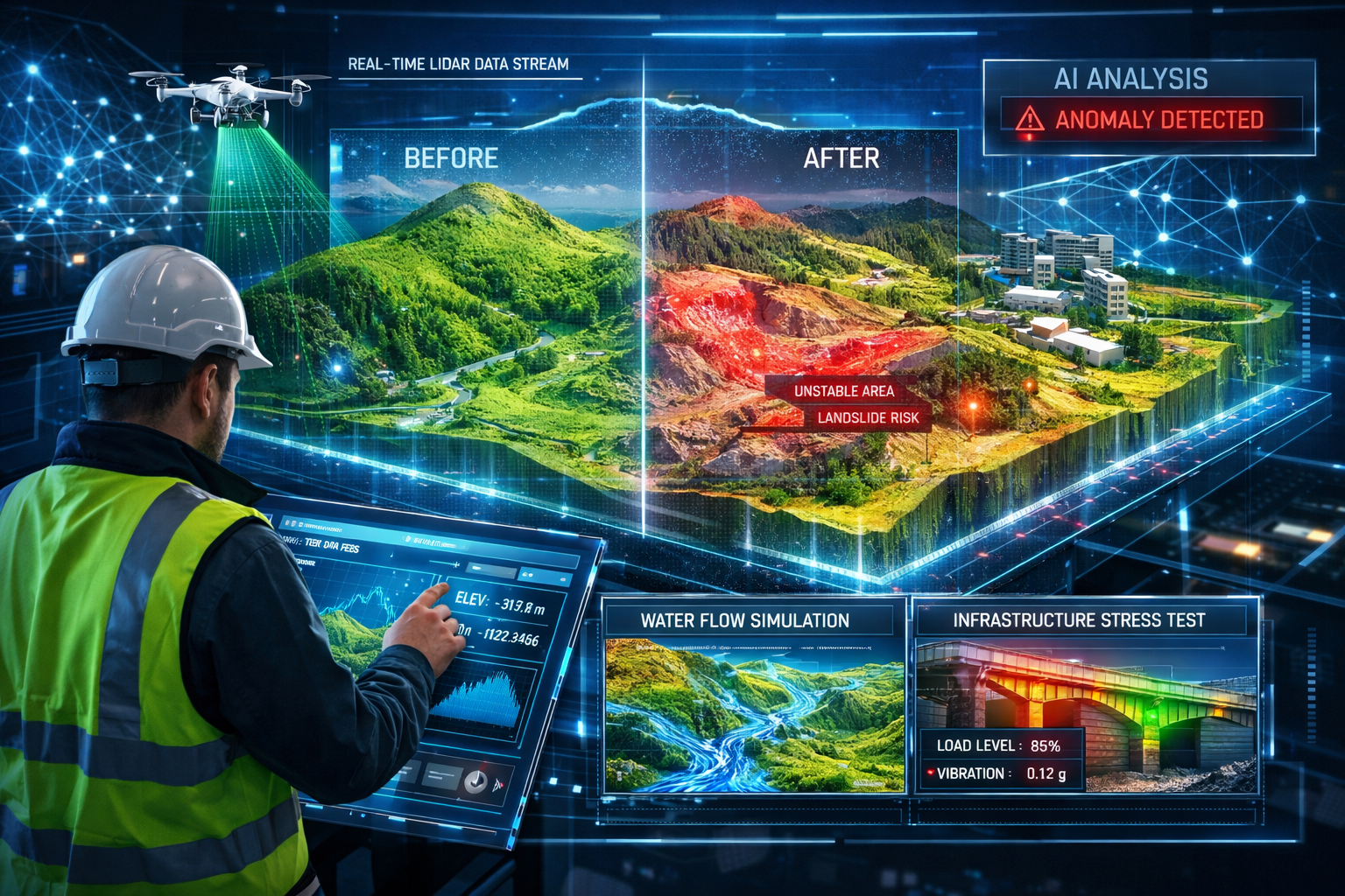
Real-Time Digital Twins: The Next Frontier
Real-time digital twins—high-fidelity, interactive 3D models that update continuously as new data is collected—are emerging as a major advancement in 2026[2]. These aren't static survey deliverables but rather living digital replicas that evolve as conditions change.
Digital twin applications in surveying include:
Slope Erosion Monitoring: Continuous updates from periodic surveys feed into predictive models that forecast erosion patterns, enabling proactive intervention before failures occur[2].
Water Flow Simulation: Topographic data combined with hydrological modeling enables visualization of drainage patterns, flood scenarios, and stormwater management performance[2].
Vegetation Pattern Analysis: Tracking vegetation growth and changes over time supports environmental management, habitat monitoring, and utility corridor maintenance[2].
Infrastructure Stress Testing: Digital twins of bridges, buildings, and other structures can incorporate survey data showing actual deformation or settlement, validating engineering models and identifying maintenance needs[2].
The power of digital twins lies in their ability to combine survey data with other information sources—weather data, traffic patterns, construction schedules, maintenance records—creating comprehensive models that support complex decision-making.
Drone Technology Integration with Surveying Systems
Unmanned aerial vehicles (UAVs) have evolved from novel surveying tools to essential components of comprehensive spatial data collection strategies. In 2026, modern UAV systems carry synchronized sensor arrays combining LiDAR, photogrammetry cameras, multispectral sensors, and thermal imaging units working simultaneously[2].
Multi-Sensor Drone Platforms
Early surveying drones typically carried a single camera or sensor. Today's professional platforms integrate multiple data collection systems:
LiDAR Sensors: Lightweight aerial LiDAR units can capture hundreds of thousands of points per second, creating detailed terrain models even through moderate vegetation cover. Drone-based LiDAR combines high-resolution laser scanning with aerial imaging to produce accurate terrain models faster than traditional ground methods[1].
RGB Cameras: High-resolution photogrammetry cameras (often 42+ megapixels) capture imagery that can be processed into orthophotos and 3D models using structure-from-motion algorithms.
Multispectral Sensors: Cameras capturing light in specific wavelength bands (including near-infrared) enable vegetation health analysis, crop monitoring, and environmental assessment.
Thermal Imaging: Infrared cameras detect temperature variations useful for building envelope analysis, solar panel inspection, and infrastructure monitoring.
The key advancement in 2026 is sensor synchronization—all these systems operate simultaneously during a single flight, capturing complementary datasets that provide comprehensive site documentation[2]. This eliminates the need for multiple flights with different sensors, saving time and battery life while ensuring perfect temporal alignment of different data types.
Autonomous Flight Planning and Adaptive Sensing
Autonomous drones can now automatically adjust altitude, angle, and sensor selection to achieve optimal readings using predictive modeling for flight path planning[2]. Rather than following pre-programmed flight paths regardless of conditions, intelligent systems adapt in real-time:
- Terrain following: Maintaining consistent altitude above ground even over varying topography, ensuring uniform data density
- Obstacle avoidance: Detecting and routing around trees, buildings, power lines, and other obstacles without manual intervention
- Lighting optimization: Adjusting flight timing or camera settings based on sun angle and cloud conditions
- Coverage verification: Identifying gaps in data coverage during flight and automatically filling them before landing
- Battery management: Calculating remaining flight time and autonomously returning to base for battery changes on large projects
These autonomous capabilities enable surveyors to focus on project planning and quality control rather than manual flight operation, improving both safety and efficiency.
Practical Applications and Project Examples
Linear Infrastructure Survey
A highway department needed topographic survey data for a 25-mile corridor to support road widening design. Traditional ground surveying would require:
- 3-4 weeks of field work with multiple survey crews
- Traffic control and safety measures for crews working near roadways
- Limited data density (spot measurements every 25-50 feet)
- Project cost: approximately $180,000
Drone-based LiDAR survey approach:
- 4 days of flight operations (weather-dependent)
- No traffic disruption or road closures required
- Complete point cloud coverage (20+ points per square foot)
- Project cost: approximately $65,000
The 64% cost reduction came primarily from eliminated traffic control costs and dramatically reduced field time. The comprehensive point cloud data also provided far more detailed information than traditional cross-sections, improving design quality and reducing the need for supplemental surveys during construction.
Quarry Volume Calculations
A mining operation needed monthly stockpile volume measurements for inventory management and billing purposes. Traditional methods involved:
- Ground-based surveys taking 1-2 days per month
- Safety concerns with surveyors working around heavy equipment
- Limited accuracy on steep stockpile slopes
- Annual surveying cost: approximately $45,000
Drone photogrammetry solution:
- 30-minute flight capturing entire quarry
- Processing creates 3D model for automated volume calculations
- No safety risks or equipment conflicts
- Annual surveying cost: approximately $12,000
The 73% cost savings combined with improved safety made the drone approach clearly superior for this application. The monthly surveys also provided valuable trend data on material movement and equipment productivity that wasn't economically feasible with traditional methods.
For surveyors interested in understanding how different survey approaches apply to property assessment, our guide on what surveyors look for in a house survey provides valuable context for residential applications.
Challenges and Considerations in Adopting New Surveying Technologies
While the benefits of modern surveying technology are substantial, The Future of Land Surveying Technology: 2026 Trends in Mobile 3D Mapping and GNSS RTK Systems also presents challenges that surveying professionals must navigate carefully.
Initial Investment and Return on Investment
Advanced surveying equipment requires significant capital investment:
- Mobile 3D mapping systems: $35,000 – $150,000 depending on capabilities
- GNSS RTK base and rover sets: $15,000 – $45,000 for professional-grade systems
- Survey-grade drones with LiDAR: $50,000 – $200,000 for complete systems
- Processing software licenses: $3,000 – $15,000 annually
- Training and certification: $2,000 – $10,000 per staff member
For small surveying firms, these costs can seem prohibitive. However, the efficiency gains typically generate positive ROI within 12-24 months for firms with steady project flow:
Example ROI Calculation for Mobile Mapping System:
- Equipment cost: $75,000
- Annual software/maintenance: $8,000
- Time savings: 30 hours per month average (based on project mix)
- Hourly billing rate: $150
- Monthly revenue increase: $4,500
- Annual additional revenue: $54,000
- Payback period: approximately 18 months
The calculation improves significantly when considering competitive advantages—winning projects specifically because of advanced capabilities, or completing projects that wouldn't be economically feasible with traditional methods.
Training and Skill Development
New technology requires new skills. Surveyors trained on traditional methods need to develop competencies in:
- Point cloud processing: Understanding software workflows for filtering, classification, and feature extraction
- GNSS troubleshooting: Diagnosing positioning issues and understanding satellite geometry, atmospheric effects, and multipath interference
- Drone operation: Obtaining required certifications and developing safe flight procedures
- Data management: Handling multi-gigabyte datasets and implementing efficient file organization systems
- Quality control: Validating automated processing results and identifying potential errors
This training investment is substantial but essential. Firms that purchase advanced equipment without adequate staff training often struggle to achieve the expected efficiency gains, leading to disappointing ROI and technology abandonment.
Professional organizations and equipment manufacturers increasingly offer structured training programs, certification courses, and ongoing support to ease this transition. Investing in comprehensive training—not just basic equipment operation but advanced techniques and troubleshooting—pays dividends in project efficiency and deliverable quality.
Data Management and Processing Infrastructure
Modern surveying equipment generates massive datasets. A single day of mobile mapping can produce 50-200 GB of raw data. This creates infrastructure requirements:
Storage: Firms need robust backup systems and archival storage. Cloud storage offers scalability but requires reliable high-speed internet connections and ongoing subscription costs.
Processing Power: Point cloud processing and photogrammetry calculations demand substantial computing resources. Many firms invest in dedicated workstations with powerful graphics cards and 64+ GB of RAM.
Workflow Management: With multiple projects generating large datasets simultaneously, firms need systematic file organization, version control, and project tracking systems.
Delivery Methods: Clients increasingly expect access to point cloud data and 3D models, not just traditional CAD drawings. Firms need platforms for sharing large files and hosting interactive 3D viewers.
These infrastructure investments, while less visible than equipment purchases, are equally critical to successful technology adoption.
Regulatory and Professional Standards
Surveying is a regulated profession with established standards for accuracy, documentation, and professional liability. New technologies must fit within these frameworks:
Accuracy Standards: Professional surveying standards specify required accuracy for different survey types. Firms must validate that new technologies meet these requirements and document their accuracy verification procedures.
Certification and Licensing: Some jurisdictions have specific requirements for surveyors using particular technologies. Understanding and complying with these regulations is essential.
Professional Liability: Insurance carriers may have questions about new technologies and their reliability. Maintaining appropriate professional liability coverage while adopting new methods requires clear communication with insurers.
Data Retention: Professional standards typically require surveyors to retain field notes and raw observations. For digital surveys, this means preserving point clouds, GNSS logs, and processing parameters—not just final deliverables.
Successful firms engage with regulatory bodies and professional organizations to ensure their technology adoption aligns with evolving standards and best practices.
Selecting the Right Technology for Your Surveying Needs
Not every surveying project requires the latest technology. The Future of Land Surveying Technology: 2026 Trends in Mobile 3D Mapping and GNSS RTK Systems offers a diverse toolkit, and successful surveyors choose the right tools for each specific application.
Project Type Considerations
Different survey types have distinct requirements that favor particular technologies:
Boundary Surveys: GNSS RTK systems excel at boundary work, providing efficient monument location and boundary traverse with centimeter accuracy. Mobile mapping may be overkill unless comprehensive topographic data is also needed.
Topographic Surveys: Mobile 3D mapping and drone LiDAR shine for topographic work, capturing far more terrain detail than traditional methods. The choice between ground-based and aerial systems depends on site size, vegetation, and access constraints.
As-Built Documentation: Mobile mapping systems (particularly indoor-capable units) are ideal for as-built surveys of buildings and facilities, capturing comprehensive detail that would be impractical with traditional methods.
Construction Stakeout: GNSS RTK remains the gold standard for stakeout work, providing real-time positioning feedback that enables efficient point placement.
Corridor Mapping: Vehicle-mounted mobile mapping systems with integrated RTK positioning offer unmatched efficiency for linear projects like roads, utilities, and railways.
Understanding these application-specific strengths helps surveyors build technology suites that cover their typical project mix efficiently.
Site Conditions and Environmental Factors
Environmental conditions significantly influence technology selection:
Vegetation Cover: Dense tree canopy degrades GNSS accuracy and blocks aerial photogrammetry. Ground-based mobile LiDAR or total station methods may be necessary.
Urban Environments: Tall buildings create GNSS multipath and signal blockage. Mobile mapping with SLAM positioning or traditional total station methods often work better than GNSS-dependent systems.
Site Access: Restricted access or hazardous conditions favor remote sensing methods (drones) over ground-based approaches requiring physical site presence.
Weather Sensitivity: Some technologies work in conditions where others fail. Understanding these limitations enables backup planning and realistic scheduling.
Experienced surveyors evaluate site conditions during project planning and select technologies that match the environment, rather than forcing a preferred technology onto unsuitable conditions.
Budget and Timeline Constraints
Project economics ultimately drive technology selection. While advanced technologies often reduce costs through efficiency gains, they're not always the most economical choice:
Small Simple Projects: A basic boundary survey of a residential lot may be completed more economically with traditional methods than mobilizing expensive mobile mapping equipment.
Urgent Timelines: When rapid turnaround is critical, technologies that streamline data collection and processing (mobile mapping, RTK positioning) justify their costs through schedule compression.
Large Complex Projects: High-end technologies show their greatest advantages on substantial projects where efficiency gains multiply across large areas or long timelines.
Client Requirements: Some clients specifically request point cloud deliverables or 3D models, making mobile mapping technologies essential regardless of other factors.
Smart project management involves matching technology investment to project value, ensuring that advanced capabilities generate commensurate benefits.
Those evaluating survey options for property transactions can explore our comparison of different types of surveys to understand how various approaches serve different needs.
Integration with Existing Workflows and Software Systems
Technology adoption succeeds when new tools integrate seamlessly with established workflows rather than requiring complete process reinvention. Modern surveying technologies increasingly emphasize interoperability and compatibility with standard industry software.
CAD and Design Software Compatibility
Most surveying deliverables ultimately feed into CAD and civil engineering design software. Modern surveying technologies support this through:
Standard File Formats: Point cloud data exports to industry-standard formats (LAS, LAZ, E57) that import directly into AutoCAD Civil 3D, Bentley MicroStation, and other design platforms.
Direct Feature Extraction: Many point cloud processing packages can extract standard CAD entities (polylines, surfaces, 3D solids) directly from survey data, reducing manual drafting time.
Coordinate System Management: Professional surveying software handles coordinate transformations, datum conversions, and projection changes, ensuring data aligns properly with existing project control.
Quality Metadata: Modern systems embed accuracy estimates, collection dates, and equipment information within deliverable files, supporting quality documentation and professional standards.
This compatibility means surveyors can adopt new data collection technologies while maintaining familiar deliverable formats, easing client adoption and reducing training requirements.
Cloud-Based Collaboration Platforms
The surveying industry is increasingly embracing cloud-based workflows that enable real-time collaboration and instant data sharing[2]. These platforms offer several advantages:
- Field-to-office connectivity: Surveyors upload data from field equipment directly to cloud storage, enabling office staff to begin processing before field crews return
- Client portals: Interactive 3D viewers allow clients to explore survey data through web browsers without specialized software
- Version control: Cloud platforms track changes and maintain revision history, supporting quality management and professional documentation
- Multi-party collaboration: Design teams, contractors, and owners can access survey data simultaneously, improving coordination and reducing delays
- Scalable storage: Cloud infrastructure grows with project needs without requiring local hardware investments
Security and data ownership concerns initially slowed cloud adoption in surveying, but modern platforms with proper encryption, access controls, and data residency options have addressed most professional liability concerns.
Building Information Modeling (BIM) Integration
As construction projects increasingly adopt BIM workflows, surveyors play a critical role in providing accurate as-built documentation and site condition models. Modern surveying technologies support BIM integration through:
Scan-to-BIM Services: Point cloud data from mobile mapping or laser scanning serves as the foundation for creating accurate 3D BIM models of existing conditions.
Construction Verification: Comparing as-built point clouds against design BIM models identifies construction deviations and supports quality control.
Clash Detection: Combining survey data with proposed designs reveals conflicts between new construction and existing site conditions before construction begins.
Progress Monitoring: Sequential surveys throughout construction feed into 4D BIM models that track progress against schedules and support project management.
This integration positions surveyors as key contributors to modern construction workflows rather than simply providers of base mapping, expanding service offerings and increasing project value.
For professionals seeking comprehensive understanding of survey methodologies, our complete guide to home surveying offers valuable foundational knowledge applicable across survey types.
Environmental and Sustainability Benefits of Modern Surveying
Beyond efficiency and cost savings, The Future of Land Surveying Technology: 2026 Trends in Mobile 3D Mapping and GNSS RTK Systems offers significant environmental benefits that align with growing sustainability priorities across the construction and development industries.
Reduced Site Disturbance
Traditional surveying often requires clearing vegetation for sight lines, establishing multiple equipment stations across sites, and repeated site visits. Mobile mapping and drone technologies minimize these impacts:
- Single-pass data collection: Comprehensive datasets captured in one visit rather than multiple trips
- No vegetation clearing: LiDAR penetrates moderate vegetation, eliminating the need to cut sight lines
- Minimal ground disturbance: Surveyors can walk existing paths rather than traversing entire sites
- Reduced vehicle traffic: Fewer site visits mean less soil compaction and vegetation damage from vehicle access
These benefits are particularly valuable on environmentally sensitive sites where minimizing disturbance is a project priority.
Lower Carbon Footprint
Efficiency improvements translate directly to reduced environmental impact:
Reduced Travel: Completing surveys in less time with fewer site visits reduces vehicle emissions. A project requiring five traditional survey visits might be completed in a single mobile mapping session.
Smaller Crews: Single-operator mobile mapping systems eliminate the need for multi-person crews, further reducing transportation emissions.
Efficient Processing: Automated data processing reduces computer processing time and associated energy consumption compared to manual drafting and calculations.
Digital Deliverables: Electronic data sharing eliminates printing and shipping of paper plans, reducing material consumption and transportation emissions.
While individual project impacts may seem modest, these savings multiply across thousands of surveys annually, contributing meaningfully to industry sustainability goals.
Enhanced Environmental Monitoring
Modern surveying technologies enable environmental monitoring applications that were previously impractical:
Habitat Mapping: Multispectral drone sensors identify vegetation types and health, supporting habitat conservation and restoration monitoring.
Erosion Tracking: Sequential surveys detect subtle terrain changes, enabling early intervention before minor erosion becomes major problems.
Wetland Delineation: High-resolution topographic data combined with vegetation classification supports accurate wetland boundary determination.
Carbon Sequestration: LiDAR-based tree inventories calculate biomass and carbon storage, supporting climate mitigation projects and carbon credit programs.
These applications position surveyors as contributors to environmental stewardship rather than simply infrastructure development, expanding professional opportunities while supporting sustainability objectives.
Future Developments: What's Next for Land Surveying Technology
While 2026 represents a significant milestone in surveying technology evolution, the pace of innovation shows no signs of slowing. Several emerging trends will likely shape The Future of Land Surveying Technology in the years ahead.
Artificial Intelligence Advancement
Current AI applications in surveying focus primarily on classification and feature extraction. Future developments will likely include:
Predictive Modeling: AI systems that not only document current conditions but predict future changes based on environmental factors, usage patterns, and historical trends.
Automated Design Integration: Direct translation of survey data into preliminary design alternatives, with AI suggesting optimal site layouts based on topography, regulations, and project requirements.
Natural Language Interfaces: Surveyors describing desired outputs in plain language rather than learning complex software commands, with AI interpreting intent and executing appropriate processing workflows.
Anomaly Detection: Increasingly sophisticated identification of unusual conditions that may indicate errors, hazards, or important features requiring surveyor attention.
These AI advancements will further shift surveyor roles from data collection and processing toward interpretation, quality assurance, and client consultation.
Sensor Miniaturization and Cost Reduction
The trajectory of surveying technology consistently moves toward smaller, more affordable equipment:
Smartphone-Based Surveying: While current smartphone sensors lack professional-grade accuracy, continuing improvements may enable basic surveying tasks using consumer devices with appropriate software.
Wearable Sensors: Integration of surveying sensors into safety equipment, enabling passive data collection as workers move through sites.
Disposable Sensors: Low-cost monitoring devices that can be deployed across large areas for continuous environmental monitoring.
Democratized Access: Reduced equipment costs enabling smaller firms and individual practitioners to access capabilities currently limited to well-capitalized organizations.
This democratization will likely expand surveying services into applications where current costs are prohibitive, growing the overall market while increasing competitive pressure.
Continuous Monitoring and Real-Time Updates
The concept of surveying as a periodic activity—discrete projects with defined start and end dates—may evolve toward continuous monitoring models:
Permanent Installations: Fixed sensors providing ongoing monitoring of critical infrastructure, with surveyors managing data interpretation rather than periodic collection.
Automated Change Detection: Systems that continuously compare current conditions against baseline surveys, automatically alerting stakeholders to significant changes.
Living Deliverables: Survey products that update automatically as new data becomes available, rather than static documents frozen at a point in time.
Subscription Services: Business models shifting from project-based fees toward ongoing monitoring subscriptions, changing revenue patterns and client relationships.
This evolution will require surveyors to develop new skills in data management, system administration, and long-term client relationships while potentially providing more stable, predictable revenue streams.
Augmented Reality Integration
Augmented reality (AR) technologies are beginning to influence surveying workflows:
Field Visualization: AR headsets displaying design models overlaid on physical sites, enabling real-time comparison of proposed and existing conditions.
Underground Utility Visualization: Combining utility location data with AR display to show buried infrastructure as if visible through the ground.
Interactive Stakeout: AR-guided construction layout where workers see stake positions and elevations overlaid on their view of the site.
Training Applications: AR simulations enabling surveyor training without field equipment or site access.
As AR hardware becomes more practical for field use (lighter, longer battery life, better outdoor visibility), these applications will likely transition from experimental to routine.
Conclusion: Embracing The Future of Land Surveying Technology in 2026
The Future of Land Surveying Technology: 2026 Trends in Mobile 3D Mapping and GNSS RTK Systems represents far more than incremental improvements to existing methods. These technologies fundamentally transform how surveyors work, what data they can capture, and the value they deliver to clients. The efficiency gains—often 50-75% reductions in field time—translate directly to cost savings while simultaneously improving data quality and comprehensiveness.
The surveying professionals who thrive in this evolving landscape will be those who strategically adopt technologies that align with their project mix and client needs, rather than chasing every innovation or clinging exclusively to traditional methods. Success requires balancing several considerations:
✅ Investment Timing: Adopting technologies when they reach production maturity and when project volume justifies the investment
✅ Training Commitment: Ensuring staff develop genuine proficiency with new tools, not just basic operational capability
✅ Workflow Integration: Adapting office processes to leverage technology capabilities rather than forcing new tools into old workflows
✅ Quality Maintenance: Implementing validation procedures that ensure new methods meet professional standards and client expectations
✅ Client Communication: Educating clients about new capabilities and deliverable formats, managing expectations while demonstrating value
The surveying profession has weathered numerous technological transitions—from chains and compasses to electronic distance measurement, from paper plans to CAD, from single-constellation GPS to multi-GNSS RTK. Each transition initially seemed disruptive but ultimately expanded professional capabilities and opportunities. The current wave of mobile 3D mapping, advanced GNSS, AI processing, and drone integration follows this pattern, offering surveyors tools to work more efficiently while tackling projects that would have been impractical or impossible with previous technologies.
Actionable Next Steps for Surveying Professionals
For surveyors considering technology adoption in 2026, these practical steps can guide decision-making:
1. Assess Your Project Portfolio: Analyze recent projects to identify which would have benefited most from advanced technologies. Calculate potential time and cost savings to inform ROI projections.
2. Start with Rental or Service Providers: Before major equipment purchases, rent systems for specific projects or partner with service providers offering mobile mapping or drone services. This provides hands-on experience without capital commitment.
3. Invest in Training: Allocate training budgets equal to 10-15% of equipment costs. Comprehensive training accelerates proficiency and maximizes technology value.
4. Develop Hybrid Workflows: Integrate new technologies alongside traditional methods rather than complete replacement. Use each approach where it offers the greatest advantage.
5. Engage with Vendors: Establish relationships with equipment manufacturers and software developers. Many offer demonstration projects, trial periods, and application consulting.
6. Join Professional Communities: Participate in professional organizations and online communities where surveyors share experiences with new technologies, troubleshooting advice, and best practices.
7. Update Business Development: Revise marketing materials and client communications to highlight advanced capabilities. Pursue projects that specifically value these technologies.
8. Plan Infrastructure Upgrades: Ensure office computing, storage, and internet connectivity can handle the data volumes and processing requirements of modern surveying equipment.
The surveying profession stands at an exciting crossroads where traditional expertise combines with cutting-edge technology to create unprecedented capabilities. Professionals who embrace this evolution while maintaining the fundamental principles of accuracy, professionalism, and client service will find abundant opportunities in the years ahead.
For those exploring survey requirements for specific property transactions, understanding when you need a survey when buying a house provides essential context for residential real estate decisions.
The future of land surveying isn't about replacing human expertise with technology—it's about empowering skilled professionals with tools that amplify their capabilities, enabling them to deliver better results more efficiently while tackling increasingly complex challenges. As we progress through 2026 and beyond, the surveyors who master this balance will lead the profession into its next chapter of growth and innovation.
References
[1] The Future Of Land Surveying Technology And Upcoming Trends In 2026 – https://metricop.com/blogs/land-surveying/the-future-of-land-surveying-technology-and-upcoming-trends-in-2026
[2] Future Land Surveying 2026 – https://haller-blanchard.com/future-land-surveying-2026/
[3] Future Of Surveying Technology Unveiled – https://mcclurevision.com/future-of-surveying-technology-unveiled/
[4] Revolutionizing Land Surveying The Rise Of Drone Technology And Uav Applications In 2026 – https://nottinghillsurveyors.com/blog/revolutionizing-land-surveying-the-rise-of-drone-technology-and-uav-applications-in-2026
[5] 6 Geospatial Trends To Watch In 2026 Insights From Intergeo 2025 – https://geo-matching.com/articles/6-geospatial-trends-to-watch-in-2026-insights-from-intergeo-2025