
The surveying industry stands at a pivotal crossroads in 2026. As construction projects grow more complex and workforce challenges intensify, Doubling Down on Digital: Top 6 Surveying Trends Shaping 2026 from Trimble Experts reveals how technology adoption is no longer optional—it's essential for survival. With analysts estimating the construction sector will need half a million new workers in 2026 to keep pace with demand, and nearly a quarter of the current workforce set to retire within the next decade[1], surveying firms must leverage digital tools to bridge the talent gap and maintain competitive advantage.
Trimble's latest industry insights paint a clear picture: the future belongs to firms that embrace reality capture democratization, autonomous systems, AI-powered workflows, and collaborative digital ecosystems. These aren't distant possibilities—they're practical strategies being implemented by forward-thinking surveying professionals today.
Key Takeaways
- 📱 Reality capture technology is becoming accessible to firms of all sizes, with mobile phones and user-friendly systems enabling comprehensive data collection that was once reserved for specialized service providers
- 🤖 Machine control systems have evolved from optional upgrades to essential infrastructure, making accurate surveyor-provided spatial data critical for modern earthmoving projects
- 🧠 AI networks are moving beyond pilot programs to impact real-world workflows, with connected ecosystems streamlining everything from design to resource management
- 🔗 Common Data Environments (CDEs) are consolidating project information and enabling digital twins, while vendor interoperability improvements are creating seamless technology ecosystems
- 👷 Workforce shortages are driving technology adoption as the top priority, with AI and precision positioning tools viewed as essential solutions for doing more with fewer people
Understanding the Digital Transformation in Surveying

The surveying profession has always been rooted in precision and accuracy. However, the tools and methodologies used to achieve that precision have undergone dramatic evolution. In 2026, Doubling Down on Digital: Top 6 Surveying Trends Shaping 2026 from Trimble Experts represents more than just technological advancement—it signals a fundamental shift in how surveying work gets done.
Traditional surveying methods, while still valuable, are being augmented and in some cases replaced by digital workflows that deliver faster results, more comprehensive data, and better integration with downstream construction processes. This transformation affects every aspect of surveying practice, from initial site reconnaissance to final as-built verification.
The Business Case for Digital Adoption
Surveying firms face mounting pressure from multiple directions. Clients demand faster turnaround times, more detailed deliverables, and seamless integration with their project management systems. Meanwhile, finding qualified surveyors becomes increasingly challenging as experienced professionals retire and fewer young people enter the field.
Digital technologies address these challenges directly. When implemented strategically, they enable smaller teams to accomplish more work with higher quality and better documentation. The return on investment comes not just from efficiency gains, but from the ability to take on projects that would have been impossible with traditional methods alone.
For professionals seeking to understand how digital transformation impacts property assessment, our guide on comparing different types of surveys provides valuable context on how technology is reshaping traditional surveying approaches.
Trend #1: Reality Capture Democratization – From Specialized Service to Essential Toolset
Perhaps the most transformative trend identified in Doubling Down on Digital: Top 6 Surveying Trends Shaping 2026 from Trimble Experts is the democratization of reality capture technology. What was once the exclusive domain of specialized service providers with expensive equipment has become accessible to surveying firms of all sizes.
Evolution of Reality Capture Technology
Reality capture encompasses various technologies that document physical environments in three-dimensional digital formats. This includes:
- Terrestrial laser scanning (TLS) for high-precision static capture
- Mobile mapping systems for efficient corridor and site documentation
- Photogrammetry using drones and cameras
- Smartphone-based capture using LiDAR-equipped mobile devices
In 2026, these technologies are converging into user-friendly ecosystems that enable "even more comprehensive data collection and in-field treatment for faster and improved decision making, as well as capture from mobile phones and robust mobile mapping systems."[2]
AI and Machine Learning Enhancement
The real power of democratized reality capture comes from AI and machine learning algorithms that process captured data. These intelligent systems can:
✅ Automatically classify point cloud data (ground, vegetation, buildings, utilities)
✅ Extract features and measurements without manual intervention
✅ Identify changes between multiple scans for monitoring applications
✅ Generate deliverables (plans, sections, 3D models) with minimal user input
Cloud-based platforms further enhance accessibility by eliminating the need for expensive local computing infrastructure. Surveyors can capture data in the field using affordable devices, upload to the cloud for processing, and deliver results to clients—all within compressed timeframes that would have been impossible just a few years ago.
Practical Adoption Strategies for Different Firm Sizes
Small Firms (1-5 surveyors):
- Start with smartphone-based reality capture for smaller projects
- Leverage cloud processing to avoid hardware investments
- Partner with specialized providers for large-scale scanning projects
- Focus on niche applications where reality capture provides clear ROI
Medium Firms (6-20 surveyors):
- Invest in versatile mobile mapping systems for efficient site documentation
- Develop in-house expertise through training and certification programs
- Integrate reality capture with existing survey workflows
- Build service offerings around as-built documentation and monitoring
Large Firms (20+ surveyors):
- Deploy comprehensive reality capture fleets across multiple project types
- Establish dedicated processing teams and workflows
- Develop proprietary methods and quality control procedures
- Lead industry innovation through pilot projects and technology partnerships
Spatial Data as Common Visual Language
Enhanced by AI and cloud platforms, spatial data captured through reality capture serves as a "common visual language across projects."[2] This shared language enables better communication between surveyors, designers, contractors, and owners—all stakeholders can reference the same accurate digital representation of existing conditions.
This collaborative aspect transforms surveying from a transactional service (deliver drawings, move on) to an ongoing partnership where surveyors provide the foundational spatial intelligence that guides decision-making throughout the project lifecycle.
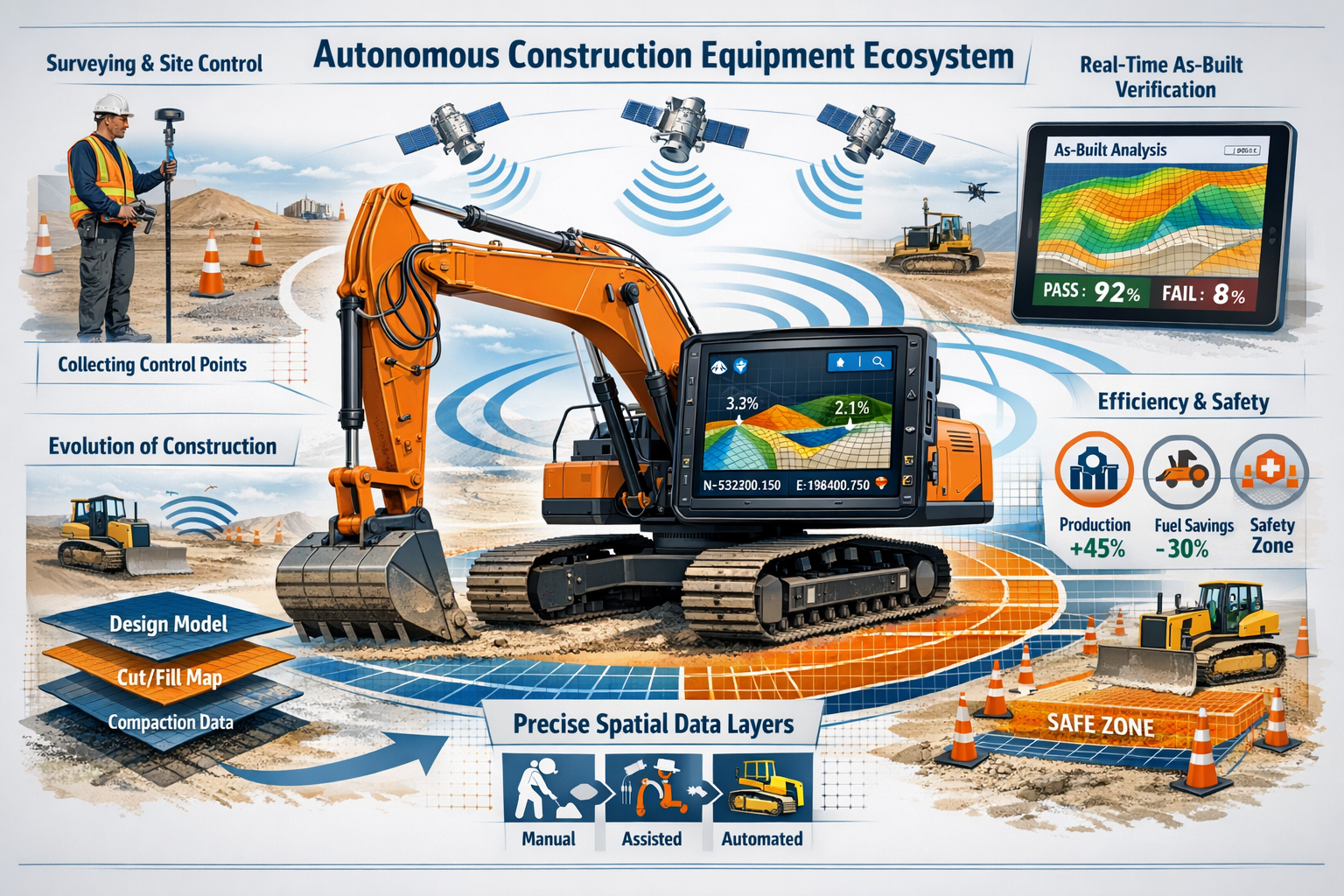
Trend #2: Autonomous Progress as Incremental Evolution
While headlines often focus on dramatic technological breakthroughs, Doubling Down on Digital: Top 6 Surveying Trends Shaping 2026 from Trimble Experts emphasizes that the construction industry's path to autonomy is "an evolution more than a revolution."[2] This steady, incremental approach has significant implications for surveying professionals.
Machine Control Systems Becoming Standard Equipment
Machine control systems—technology that guides earthmoving equipment using GPS/GNSS positioning and digital design models—are no longer viewed as optional technology. In 2026, they represent standard equipment for modern earthmoving projects.[2]
This shift fundamentally changes the surveyor's role on civil construction and site development projects. Instead of staking grades and providing periodic checks, surveyors now:
🔧 Establish and maintain site control networks with precision sufficient for machine guidance
🔧 Create and validate digital terrain models (DTMs) that machines use for automated grading
🔧 Perform as-built verification to confirm that automated work meets specifications
🔧 Troubleshoot positioning and accuracy issues when machines report problems
Critical Importance of Accurate, Timely Data
For surveyors working on earthmoving and civil construction projects, providing accurate, timely data that feeds machine control systems is increasingly critical.[2] The quality of surveyor-provided spatial information directly impacts:
| Impact Area | Consequence of Poor Data | Benefit of Quality Data |
|---|---|---|
| Efficiency | Machines operate slowly or require manual intervention | Optimal machine performance and productivity |
| Safety | Increased risk of grade errors and equipment conflicts | Confident autonomous operation within safe parameters |
| Quality | Rework and specification failures | First-time quality achievement |
| Cost | Material waste and schedule delays | Minimized waste and on-schedule completion |
Site control work, digital terrain models, and as-built verification become even more important as machines rely on precise spatial information to operate efficiently and safely.[2]
Surveyor Skills for the Autonomous Era
The evolution toward autonomous construction requires surveyors to develop new competencies:
Technical Skills:
- Understanding machine control system requirements and workflows
- Creating and managing 3D design surfaces and corridor models
- Troubleshooting GNSS positioning and correction service issues
- Quality control procedures for automated construction verification
Communication Skills:
- Explaining spatial data requirements to contractors and operators
- Coordinating with designers to ensure models are construction-ready
- Documenting and reporting on automated construction progress
Strategic Thinking:
- Anticipating data needs throughout the construction process
- Designing control networks that support multiple machine types
- Planning verification strategies for autonomous work
These skills complement rather than replace traditional surveying fundamentals. The best surveyors in 2026 combine classical knowledge with modern digital capabilities.
Trend #3: AI Networks Moving Beyond Pilot Programs
Artificial intelligence represents one of the most discussed aspects of Doubling Down on Digital: Top 6 Surveying Trends Shaping 2026 from Trimble Experts. In 2026, isolated agentic AI pilots are moving beyond experimentation to impact real-world workflows, with "networks of AI agents operating across design, engineering and construction in connected ecosystems—streamlining design processes, orchestrating schedules, resolving conflicts, tracking progress, managing resources and more."[1]
From Isolated Tools to Connected Ecosystems
Early AI applications in construction focused on narrow, specific tasks: identifying objects in images, predicting equipment maintenance needs, or optimizing single aspects of scheduling. While valuable, these isolated applications failed to deliver transformative impact.
The 2026 evolution involves AI networks—multiple specialized AI agents working together across the project lifecycle:
Design Phase AI Agents:
- Analyze site conditions from survey data
- Generate design alternatives based on constraints
- Optimize layouts for constructability and cost
- Flag potential conflicts before they reach construction
Construction Phase AI Agents:
- Monitor progress against schedule and budget
- Predict delays and resource bottlenecks
- Coordinate equipment and labor allocation
- Verify quality through automated inspection
Surveying-Specific AI Applications:
- Automated feature extraction from point clouds
- Intelligent quality control of survey data
- Predictive modeling for monitoring applications
- Anomaly detection in as-built verification
Practical AI Adoption for Surveying Firms
Many surveying professionals feel overwhelmed by AI hype and uncertain about practical implementation. Here's a realistic adoption pathway:
Phase 1: Leverage Built-In AI (0-6 months)
- Use AI features already embedded in existing software
- Enable automated classification in point cloud processing
- Activate intelligent feature extraction tools
- Learn what AI can and cannot do reliably
Phase 2: Targeted Problem Solving (6-18 months)
- Identify specific bottlenecks in current workflows
- Evaluate AI-powered solutions for those specific problems
- Pilot on non-critical projects to build confidence
- Measure and document efficiency improvements
Phase 3: Workflow Integration (18-36 months)
- Redesign workflows around AI-enhanced capabilities
- Train staff on AI-assisted methodologies
- Develop quality control procedures for AI outputs
- Scale successful pilots across the organization
Phase 4: Strategic Differentiation (36+ months)
- Develop proprietary AI-enhanced service offerings
- Partner with technology providers on innovation
- Lead client education on AI capabilities
- Build competitive advantage through AI expertise
Managing Client Expectations
As AI capabilities expand, clients may develop unrealistic expectations about speed, cost, and deliverables. Successful surveying firms in 2026 proactively educate clients about:
- What AI can reliably automate versus what still requires professional judgment
- How AI-enhanced workflows impact project timelines and budgets
- The continuing importance of human expertise in quality control and interpretation
- Appropriate applications for different AI-powered surveying methods
Those interested in understanding how modern surveying integrates with construction projects can explore our comprehensive guide to commercial building surveys for practical insights.
Trend #4: Common Data Environments Consolidating Project Information
Common Data Environments (CDEs) represent critical infrastructure highlighted in Doubling Down on Digital: Top 6 Surveying Trends Shaping 2026 from Trimble Experts. These platforms "minimize time contractors waste trying to search for information" by consolidating data from design, engineering, fabrication, construction and maintenance into a secure, accessible hub.[2]
The CDE Value Proposition
Traditional project information management involves fragmented systems: design files in one location, survey data in another, construction documents elsewhere, and as-built information scattered across multiple sources. This fragmentation creates:
❌ Time waste searching for current information
❌ Version control problems when multiple copies exist
❌ Communication failures when stakeholders work from different data
❌ Knowledge loss when information isn't properly archived
CDEs address these challenges by providing a single source of truth where all project stakeholders access current, validated information. For surveyors, CDEs offer specific benefits:
✅ Centralized data delivery – Upload survey deliverables to one location accessible by all stakeholders
✅ Version tracking – Maintain clear records of when surveys were performed and data updated
✅ Integration capabilities – Connect survey data with design models, construction schedules, and other project systems
✅ Long-term archiving – Preserve survey data for future reference, warranty work, and facility management
Digital Twins and the Physical-Digital Bridge
CDEs enable development of digital twins—virtual replicas of physical assets that mirror their real-world counterparts.[2] Survey data provides the foundational geometry for digital twins, ensuring they accurately represent as-built conditions.
The digital twin concept extends throughout the asset lifecycle:
Construction Phase:
- Survey data captures existing conditions
- Design models represent intended construction
- As-built surveys verify construction accuracy
- The digital twin evolves as construction progresses
Operations Phase:
- Facility managers reference the digital twin for maintenance planning
- Monitoring surveys detect changes and deterioration
- Renovation projects use the digital twin as a baseline
- The twin serves as the permanent record of the asset
Surveyor Responsibilities in CDE Workflows
Participating effectively in CDE-based projects requires surveyors to adapt their deliverable formats and workflows:
Data Standards Compliance:
- Deliver data in formats specified by the CDE platform
- Follow naming conventions and organizational structures
- Include required metadata with all deliverables
- Maintain consistency across multiple survey phases
Quality Assurance:
- Verify data integrity before uploading to CDE
- Document accuracy, methods, and limitations
- Respond promptly to stakeholder questions about survey data
- Update information when conditions change or errors are discovered
Collaboration Skills:
- Understand how other disciplines use survey data
- Coordinate with designers on model integration
- Support contractors using survey data for layout and verification
- Communicate effectively within the CDE platform
For professionals working with building assessments, understanding how survey data integrates with broader evaluation frameworks is essential. Our Level 2 vs Level 3 survey comparison explores different assessment approaches and their data requirements.
Trend #5: Vendor Acceleration on Interoperability Improvements
A critical aspect of Doubling Down on Digital: Top 6 Surveying Trends Shaping 2026 from Trimble Experts involves vendor commitments to enhanced interoperability. Construction technology vendors, including Trimble, are expected to "accelerate efforts to enhance interoperability, delivering greater value to contractors" through workflows and integrations between construction technology ecosystems.[2]
The Interoperability Challenge
Historically, construction technology evolved as isolated silos. Each vendor developed proprietary file formats, data structures, and workflows optimized for their specific tools. While this approach allowed rapid innovation, it created friction when users needed to exchange data between systems.
Surveyors experienced this friction acutely:
- Survey data captured in one format required conversion for design software
- Point clouds processed in one platform couldn't easily transfer to another
- Machine control systems needed data formatted specifically for their requirements
- As-built verification required reformatting data for comparison tools
2026 Interoperability Improvements
The vendor ecosystem is responding to user demands for seamless data exchange. Key developments include:
Open Standards Adoption:
- Industry-wide file formats (LAS/LAZ for point clouds, IFC for building models)
- Standardized coordinate system definitions and transformations
- Common metadata schemas for survey deliverables
- API-based data exchange protocols
Direct Integrations:
- Software partnerships enabling one-click data transfer
- Cloud-based platforms that natively support multiple formats
- Automated conversion tools with quality validation
- Bidirectional synchronization for collaborative workflows
Ecosystem Platforms:
- Vendor-neutral hubs that connect multiple technology systems
- Workflow automation across previously isolated tools
- Unified user interfaces for managing diverse data sources
- Enterprise-level orchestration of complex technology stacks
Rising Expectations for Data Quality
However, improved interoperability also raises expectations for data quality and formatting as systems connect more easily.[2] When data flows seamlessly between systems, problems that were once hidden by manual conversion processes become immediately apparent:
Quality Issues Exposed by Interoperability:
- Coordinate system inconsistencies causing misalignment
- Incomplete metadata preventing proper data classification
- Accuracy limitations inadequate for downstream applications
- File corruption or formatting errors breaking automated workflows
Successful surveying firms in 2026 recognize that interoperability demands higher standards for:
🎯 Accuracy documentation – Clear statements of precision and methodology
🎯 Metadata completeness – All required information properly embedded
🎯 Format compliance – Strict adherence to specified standards
🎯 Quality control – Verification before data enters connected systems
Strategic Technology Selection
With improved interoperability, surveying firms have more flexibility in technology selection. Rather than being locked into a single vendor ecosystem, firms can:
- Choose best-in-class tools for specific applications
- Swap underperforming solutions without disrupting entire workflows
- Negotiate better terms knowing alternatives exist
- Innovate by combining tools in novel ways
However, this flexibility requires strategic thinking about technology architecture. Firms should evaluate:
- Which core platforms anchor their workflows
- Where specialized tools add value
- How data flows between systems
- What skills staff need to manage diverse technology stacks
Trend #6: 3D GIS and Visualization-Driven Collaboration
The final major trend in Doubling Down on Digital: Top 6 Surveying Trends Shaping 2026 from Trimble Experts involves innovations in 3D GIS and modeling technology creating "richer, more precise models of public assets," with GIS-centric asset lifecycle management being redefined by AI, real-time spatial insights and secure data sharing.[2]
Evolution from 2D Plans to 3D Collaboration Spaces
Traditional design and construction collaboration centered on 2D plan sheets. Stakeholders reviewed drawings, marked up changes, and communicated through written notes and verbal discussions. While this approach worked, it created communication barriers and left room for misinterpretation.
In 2026, design conversations increasingly take place directly within 3D models rather than on traditional 2D plans, enabling "quicker iterations, faster workflows and stronger alignment throughout design and construction."[2]
Benefits of 3D-Centric Collaboration:
| Aspect | 2D Plan-Based | 3D Model-Based |
|---|---|---|
| Visualization | Requires spatial interpretation skills | Intuitive understanding for all stakeholders |
| Clash Detection | Manual coordination between disciplines | Automated conflict identification |
| Design Review | Sequential markup and revision cycles | Real-time collaborative sessions |
| Client Communication | Explaining technical drawings | Immersive walkthroughs and visualizations |
| Field Reference | Interpreting plans in 3D space | Direct comparison of model to reality |
Spatial Data as Collaboration Foundation
Spatial data becomes the foundation for collaboration as discussions are centralized and stakeholders can provide context and make decisions in real time.[2] Survey data plays a crucial role in this collaborative environment:
Survey Contributions to 3D Collaboration:
- Accurate base geometry ensuring all stakeholders work from correct existing conditions
- As-built verification confirming construction matches design intent
- Monitoring data showing changes over time
- Reality capture providing visual context for design decisions
Asset Management Applications
The convergence of 3D GIS, modeling technology, and AI is transforming how organizations manage physical assets. Surveying firms supporting asset owners can provide value through:
Initial Asset Documentation:
- Comprehensive reality capture of facilities and infrastructure
- Creation of intelligent 3D models with asset attributes
- Integration with GIS systems for spatial context
- Establishment of baseline conditions for future monitoring
Ongoing Monitoring and Maintenance:
- Periodic surveys detecting changes and deterioration
- Deformation monitoring for critical structures
- Condition assessment supporting maintenance planning
- Emergency response documentation after incidents
Renovation and Expansion:
- Current as-built data for design teams
- Clash detection between new and existing elements
- Construction verification ensuring proper integration
- Updated models reflecting completed work
Practical Implementation for Surveyors
Surveying firms can position themselves for 3D collaboration workflows by:
Building Technical Capabilities:
- Developing expertise in 3D modeling software beyond traditional CAD
- Learning BIM (Building Information Modeling) principles and workflows
- Understanding GIS platforms and spatial database management
- Mastering visualization tools for client presentations
Adapting Deliverable Formats:
- Moving beyond traditional 2D plan deliverables
- Creating intelligent 3D models with embedded attributes
- Providing data in formats compatible with collaboration platforms
- Offering visualization services (renderings, animations, virtual tours)
Enhancing Communication Skills:
- Facilitating 3D design review sessions
- Explaining spatial relationships using visual tools
- Supporting non-technical stakeholders in understanding 3D data
- Coordinating between multiple disciplines in shared 3D environments
For those conducting property assessments, our comprehensive house survey checklist demonstrates how thorough inspection practices integrate with modern documentation approaches.
Workforce Challenges Driving Technology Adoption
While Doubling Down on Digital: Top 6 Surveying Trends Shaping 2026 from Trimble Experts focuses on technological trends, the underlying driver is workforce shortage. The construction sector's need for half a million new workers in 2026[1] affects surveying firms directly.
The Talent Crisis in Numbers
The surveying profession faces a demographic challenge:
📊 Nearly 25% of current surveyors will retire within the next decade[1]
📊 Fewer young people are entering surveying programs
📊 Competition for talent from other industries intensifies
📊 Project complexity increases while available expertise decreases
This creates a fundamental equation: firms must accomplish more work with fewer experienced professionals. Technology provides the multiplier effect that makes this possible.
Technology as Workforce Multiplier
Strategic technology adoption enables smaller teams to deliver results that previously required larger crews:
Reality Capture Example:
- Traditional approach: 4-person crew spending 3 days measuring a complex site
- Technology-enabled approach: 2-person crew spending 1 day scanning, with office processing
Machine Control Example:
- Traditional approach: Survey crew staking grades, then returning for verification
- Technology-enabled approach: Provide digital model once, machines self-guide, automated as-built verification
AI-Enhanced Processing Example:
- Traditional approach: Experienced technician manually extracting features from point clouds
- Technology-enabled approach: AI automated extraction with technician reviewing and validating results
Attracting and Retaining Talent
Modern technology also helps firms attract younger workers who expect digital workflows:
Technology-Forward Firm Advantages:
✨ More appealing to tech-savvy graduates
✨ Faster skill development through intuitive tools
✨ Better work-life balance through efficiency
✨ Career growth opportunities in emerging specialties
Firms that resist digital transformation risk becoming unattractive to the next generation of surveying professionals, creating a vicious cycle of talent shortage and competitive disadvantage.
Training and Skill Development
Successfully implementing the trends identified in Doubling Down on Digital: Top 6 Surveying Trends Shaping 2026 from Trimble Experts requires investment in training:
Formal Training Programs:
- Vendor certification courses for specific technologies
- Industry association workshops and conferences
- Online learning platforms for flexible skill development
- University partnerships for emerging technology education
Internal Knowledge Transfer:
- Mentorship pairing experienced surveyors with technology specialists
- Documentation of best practices and workflows
- Regular internal training sessions on new capabilities
- Cross-training to build redundancy and flexibility
Continuous Learning Culture:
- Allocating time and budget for ongoing education
- Encouraging experimentation and innovation
- Sharing lessons learned from pilots and projects
- Celebrating successful technology adoption
Industry Priorities: What Contractors Value Most
Understanding contractor priorities helps surveyors align their services with market demands. According to Trimble's research, if costs were no object, industry leaders prioritize AI adoption and precision positioning technologies, with contractors confirming that "advanced tools can help them succeed" and that investing in them, connecting them and training their workforce to optimize them are top priorities.[1]
Top Technology Priorities for 2026
Priority #1: AI and Machine Learning
Contractors recognize AI's potential to address workforce shortages, improve decision-making, and optimize operations. Surveyors supporting these priorities can:
- Provide AI-processed deliverables with faster turnaround
- Offer predictive analytics for monitoring applications
- Support automated quality control workflows
- Integrate with contractor AI systems
Priority #2: Precision Positioning Technologies
GNSS, total stations, and positioning systems remain fundamental to construction accuracy. Surveyor value propositions include:
- Establishing robust control networks
- Supporting machine control implementations
- Providing real-time positioning services
- Troubleshooting accuracy issues
Priority #3: Connected Technology Ecosystems
Contractors want systems that work together seamlessly. Surveyors can support this by:
- Delivering data in interoperable formats
- Participating in CDE platforms
- Integrating with contractor technology stacks
- Providing API access to survey data
Aligning Surveying Services with Market Needs
Successful surveying firms in 2026 design their service offerings around contractor priorities:
Service Development Strategy:
- Research what technologies contractors in your market are adopting
- Identify how survey data supports those technologies
- Develop capabilities to provide data in required formats
- Market your services emphasizing contractor benefits
- Continuously refine based on feedback and results
Value Communication:
Rather than selling "survey services," leading firms sell outcomes:
- "Machine-ready digital terrain models for automated grading"
- "AI-processed as-built verification with automated compliance reporting"
- "Reality capture integrated with your BIM platform"
- "Real-time monitoring data feeding your project dashboard"
This outcome-focused positioning resonates with contractors facing their own workforce and efficiency challenges.
Implementation Roadmap: From Awareness to Excellence
Understanding the trends identified in Doubling Down on Digital: Top 6 Surveying Trends Shaping 2026 from Trimble Experts is valuable, but implementation separates successful firms from those left behind. Here's a practical roadmap:
Phase 1: Assessment and Planning (Months 1-3)
Current State Analysis:
- Inventory existing technology and capabilities
- Identify workflow bottlenecks and inefficiencies
- Survey staff about technology comfort and training needs
- Analyze client feedback and market positioning
Opportunity Identification:
- Research which trends offer greatest ROI for your firm size and market
- Evaluate technology options and vendor partners
- Calculate investment requirements and expected returns
- Prioritize initiatives based on impact and feasibility
Strategic Planning:
- Develop 3-year technology roadmap
- Allocate budget for technology and training
- Assign responsibility for implementation leadership
- Set measurable goals and success metrics
Phase 2: Foundation Building (Months 4-12)
Quick Wins:
- Implement high-impact, low-complexity improvements
- Activate underutilized features in existing software
- Standardize workflows and deliverable formats
- Document current processes before changing them
Pilot Projects:
- Test new technologies on non-critical projects
- Measure performance against traditional methods
- Gather feedback from staff and clients
- Refine approaches based on lessons learned
Skill Development:
- Begin formal training programs
- Hire or develop technology champions
- Create internal knowledge-sharing systems
- Build relationships with technology vendors
Phase 3: Scaling and Integration (Months 13-24)
Workflow Redesign:
- Implement successful pilots across the organization
- Redesign processes around new capabilities
- Integrate technologies into connected workflows
- Update quality control procedures
Service Expansion:
- Launch new service offerings based on technology capabilities
- Market enhanced capabilities to existing and new clients
- Develop case studies demonstrating value
- Build reputation as technology leader
Organizational Change:
- Adjust staffing and organizational structure
- Update job descriptions and hiring criteria
- Refine compensation to reward technology expertise
- Strengthen technology-forward culture
Phase 4: Optimization and Innovation (Months 25-36)
Performance Optimization:
- Analyze metrics and identify improvement opportunities
- Fine-tune workflows for maximum efficiency
- Eliminate remaining manual bottlenecks
- Achieve consistent quality across all projects
Competitive Differentiation:
- Develop proprietary methods and approaches
- Lead industry innovation through R&D
- Partner with technology vendors on product development
- Establish thought leadership through publications and presentations
Continuous Improvement:
- Maintain awareness of emerging technologies
- Regularly reassess strategy and priorities
- Invest in ongoing training and development
- Adapt to changing market conditions
For professionals working on specific property types, understanding specialized survey requirements is crucial. Our guide on surveys for new build properties explores how modern construction methods intersect with surveying practices.
Risk Management and Quality Control in Digital Workflows

As surveying firms embrace the trends outlined in Doubling Down on Digital: Top 6 Surveying Trends Shaping 2026 from Trimble Experts, they must also address new risk and quality control challenges.
Technology-Specific Risks
Data Security and Privacy:
- Cloud-based platforms create cybersecurity vulnerabilities
- Reality capture may inadvertently document sensitive information
- Client data requires protection throughout storage and transmission
- Regulatory compliance (GDPR, industry-specific requirements)
Technology Dependence:
- System failures can halt operations
- Vendor discontinuation of products or services
- Obsolescence of proprietary formats
- Loss of traditional skills as backup
Quality Control Challenges:
- Automated processes may mask errors
- AI outputs require validation
- Interoperability issues causing data corruption
- Version control in collaborative environments
Quality Assurance Framework
Input Quality Control:
- Verify calibration and accuracy of capture devices
- Validate control networks and reference systems
- Check environmental conditions during data collection
- Document all field procedures and observations
Processing Quality Control:
- Validate automated processing results
- Implement redundant checks for critical deliverables
- Maintain audit trails of processing steps
- Compare AI outputs against manual verification samples
Output Quality Control:
- Verify deliverable accuracy against specifications
- Check format compliance and metadata completeness
- Test data in client systems before final delivery
- Obtain client confirmation of usability
Continuous Monitoring:
- Track quality metrics across all projects
- Analyze errors and near-misses for patterns
- Update procedures based on lessons learned
- Benchmark performance against industry standards
Professional Liability Considerations
Digital workflows create new professional liability exposures:
Scope Definition:
- Clearly define what technologies will be used
- Specify deliverable formats and accuracy standards
- Document limitations of automated methods
- Obtain client acknowledgment of scope
Documentation:
- Maintain comprehensive project records
- Document all assumptions and decisions
- Preserve raw data and processing logs
- Create clear audit trails
Professional Standards:
- Ensure compliance with licensing requirements
- Follow industry standards and best practices
- Maintain appropriate professional liability insurance
- Seek legal review of contracts and terms
The Future Beyond 2026: Preparing for Continued Evolution
While Doubling Down on Digital: Top 6 Surveying Trends Shaping 2026 from Trimble Experts focuses on immediate trends, successful firms also prepare for longer-term evolution.
Emerging Technologies on the Horizon
Quantum Positioning:
- Next-generation positioning systems with unprecedented accuracy
- Reduced dependence on satellite infrastructure
- Indoor and underground positioning capabilities
- Integration with existing GNSS systems
Extended Reality (XR):
- Augmented reality for field visualization and layout
- Virtual reality for design review and collaboration
- Mixed reality combining digital and physical worlds
- Immersive client experiences
Advanced AI and Automation:
- Fully autonomous surveying systems
- Predictive modeling for infrastructure management
- Natural language interfaces for data query
- Self-optimizing workflows
Blockchain and Distributed Ledgers:
- Immutable records of survey data and certifications
- Decentralized data ownership and sharing
- Smart contracts for automated project workflows
- Enhanced trust and transparency
Building Adaptive Capacity
Rather than trying to predict specific future technologies, leading firms build adaptive capacity:
Organizational Agility:
- Flat structures enabling rapid decision-making
- Cross-functional teams comfortable with change
- Regular strategic reviews and course corrections
- Culture that embraces experimentation
Financial Flexibility:
- Balanced investment between current and emerging technologies
- Reserve funds for opportunistic technology adoption
- Diversified revenue streams reducing dependence on any single service
- Strong cash flow supporting ongoing innovation
Knowledge Networks:
- Active participation in industry associations
- Relationships with technology vendors and researchers
- Peer networks for sharing insights and experiences
- Academic partnerships for early access to innovations
Talent Development:
- Hiring for learning ability over specific skills
- Investment in continuous education
- Retention of innovative, forward-thinking staff
- Succession planning ensuring continuity
Conclusion: Embracing Digital Transformation for Competitive Advantage
Doubling Down on Digital: Top 6 Surveying Trends Shaping 2026 from Trimble Experts reveals that the surveying profession stands at a critical juncture. The convergence of reality capture democratization, autonomous systems evolution, AI network deployment, common data environments, vendor interoperability, and 3D collaboration workflows is fundamentally reshaping how surveying work gets done.
These trends aren't abstract concepts—they represent practical strategies that surveying firms of all sizes can implement to address workforce shortages, meet rising client expectations, and build competitive advantage. The firms that will thrive in 2026 and beyond are those that recognize technology not as a threat to traditional surveying, but as a powerful enabler of better outcomes.
Key Success Factors
✅ Start with strategy, not technology – Understand your business goals before selecting tools
✅ Focus on outcomes, not features – Choose technologies that solve real problems
✅ Invest in people alongside technology – Training and culture matter as much as equipment
✅ Embrace interoperability – Build flexible technology ecosystems, not isolated silos
✅ Maintain quality standards – Automation doesn't eliminate the need for professional judgment
✅ Communicate value clearly – Help clients understand how technology benefits their projects
Actionable Next Steps
For surveying firms ready to implement these trends:
Immediate Actions (This Week):
- Assess your current technology capabilities and gaps
- Identify one high-impact, low-complexity improvement to implement
- Research training opportunities for priority technologies
- Schedule a team discussion about digital transformation strategy
Short-Term Actions (Next 3 Months):
- Develop a technology roadmap aligned with business goals
- Pilot one new technology on a suitable project
- Establish relationships with key technology vendors
- Create internal knowledge-sharing systems
- Update marketing materials to reflect digital capabilities
Medium-Term Actions (Next 12 Months):
- Implement successful pilots across the organization
- Launch new service offerings based on technology capabilities
- Build a culture of continuous learning and innovation
- Measure and communicate ROI from technology investments
- Position your firm as a technology leader in your market
The surveying profession has always adapted to technological change—from chains and transits to total stations and GPS. The digital transformation outlined in Doubling Down on Digital: Top 6 Surveying Trends Shaping 2026 from Trimble Experts represents the next chapter in this ongoing evolution. Firms that embrace these trends with strategic intent, quality focus, and commitment to continuous improvement will not just survive—they'll lead the industry into its digital future.
For comprehensive guidance on building surveys and modern assessment techniques, explore our resources on RICS building surveys and building survey services to understand how traditional expertise integrates with digital innovation.
The future of surveying is digital, collaborative, and powered by intelligent systems. The question isn't whether to embrace these trends—it's how quickly and effectively your firm will implement them to serve clients, empower staff, and build lasting competitive advantage.
References
[1] Future Construction Technology Trends Contractor Survey – https://www.trimble.com/blog/trimble/en-US/article/future-construction-technology-trends-contractor-survey
[2] Doubling Down On Digital – https://amerisurv.com/2026/02/01/doubling-down-on-digital/