
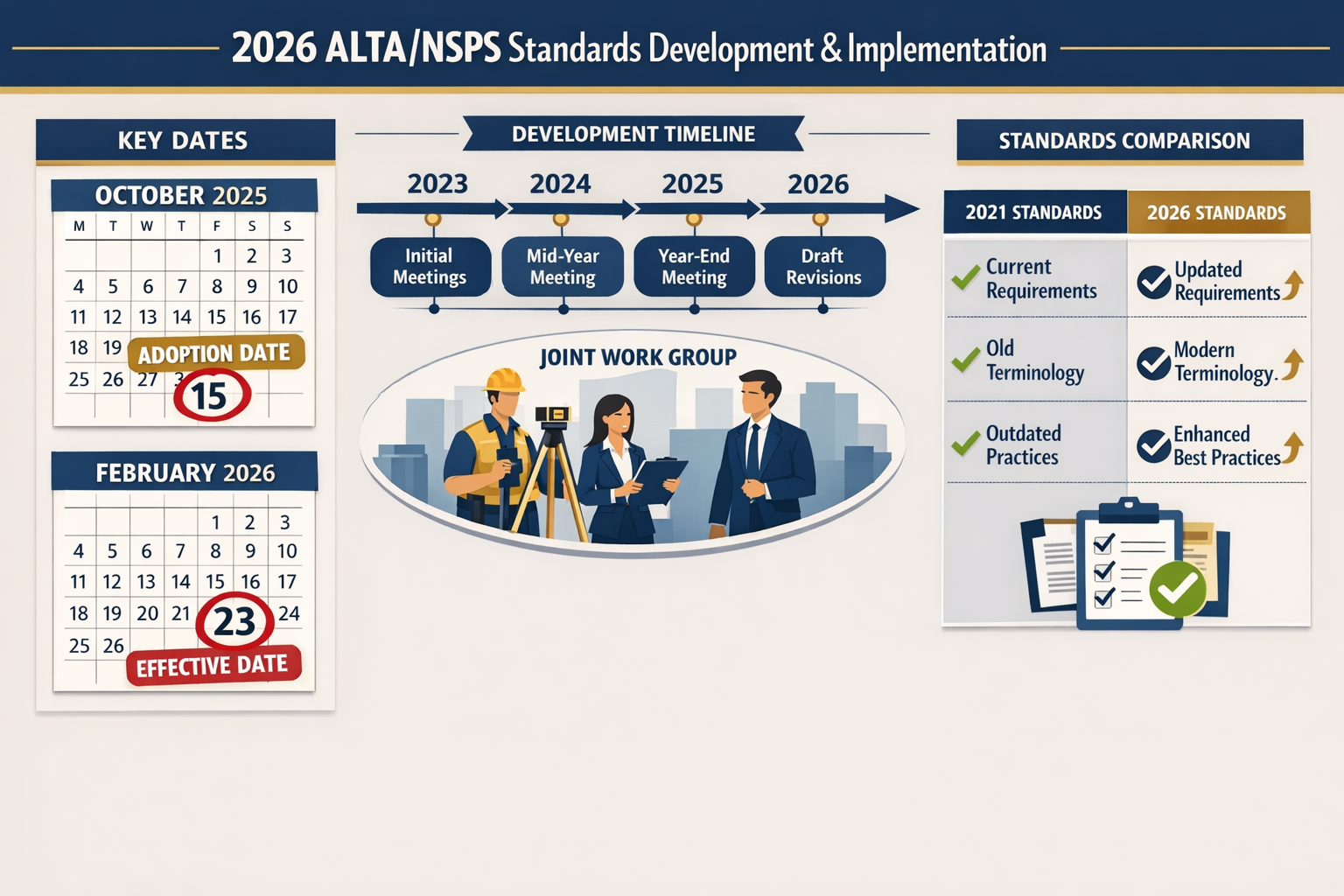
The countdown is on. February 23, 2026 marks a critical turning point for land surveyors and real estate professionals across the United States. On this date, the new 2026 ALTA/NSPS Land Title Survey Standards officially take effect, replacing the 2021 Minimum Standard Detail Requirements that have governed commercial real estate transactions for the past five years. For surveyors, title companies, lenders, and property buyers, understanding these changes isn't just recommended—it's essential for compliance, risk mitigation, and smooth transactions.
The 2026 ALTA/NSPS Land Title Survey Updates: What Surveyors and Clients Must Know Before the February Deadline represent the culmination of over three years of collaborative work between the American Land Title Association (ALTA) and the National Society of Professional Surveyors (NSPS). These updates introduce significant changes to survey requirements, reporting standards, and professional responsibilities that will impact every commercial real estate transaction moving forward.
Key Takeaways
- ✅ February 23, 2026 is the mandatory compliance date—all surveys with contracts executed on or after this date must follow the new 2026 Standards[1][3]
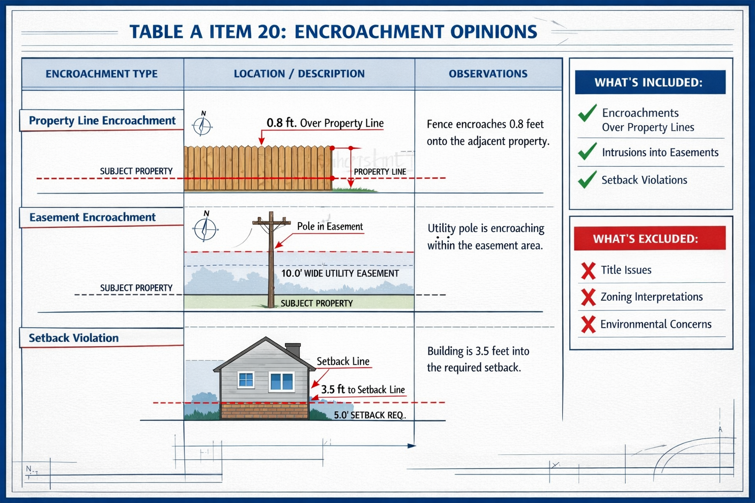
- 📊 Table A Item 20 introduces structured encroachment reporting—surveyors must now provide detailed observations of potential encroachments in a standardized table format[3]
- 🛰️ Expanded imagery use is permitted—aerial and satellite imagery can replace ground surveying for certain features, with specific restrictions for boundaries and critical elements[1]
- 📋 Title evidence requirements have been refined—surveyors need either the most recent title commitment or alternative title evidence acceptable to the title insurer[1][5]
- 🎯 Precision specifications are enhanced—new "Relative Positional Precision" definitions provide clearer measurement standards[6]
Understanding the 2026 ALTA/NSPS Standards Development Process
The Three-Year Collaborative Journey
The path to the 2026 standards began long before their October 2025 adoption. The Joint ALTA/NSPS Work Group, chaired by Todd D'Amico, PS of Oklahoma, brought together roughly equal numbers of professional surveyors and title professionals in a collaborative effort spanning more than three years[1]. This balanced representation ensured that the updated standards address the practical needs of both the surveying profession and the title insurance industry.
Meeting semi-annually, the work group carefully evaluated feedback from practitioners, reviewed emerging technologies, and addressed ambiguities in the 2021 standards. This methodical approach reflects the importance of these standards in protecting property rights and facilitating commercial real estate transactions worth billions of dollars annually.
The Five-Year Update Cycle
The 2026 updates continue the established pattern of five-year revision cycles for ALTA/NSPS standards. Previous comparable updates occurred in 2021, with each iteration building upon lessons learned and technological advances in the surveying profession[3][4]. This regular update schedule ensures that standards remain current with industry practices, legal developments, and technological capabilities.
For property surveyors, this cyclical approach provides predictability while allowing for necessary evolution in professional standards.
Critical Changes in the 2026 ALTA/NSPS Land Title Survey Updates
The Game-Changing Table A Item 20: Encroachment Opinions
Perhaps the most significant addition to the 2026 ALTA/NSPS Land Title Survey Updates: What Surveyors and Clients Must Know Before the February Deadline is the new Table A Item 20, which addresses encroachment observations in a structured, standardized format[3].
What Table A Item 20 Requires
When requested by clients, surveyors must now provide a detailed table documenting potential observations of:
- Encroachments over property lines (improvements or features crossing boundary lines)
- Encroachments into rights-of-way or easements (structures or objects within designated utility or access corridors)
- Encroachments into setbacks (violations of minimum distance requirements from property boundaries)
What Surveyors Are NOT Required to Provide
Critically, Table A Item 20 explicitly excludes legal opinions on ownership[3]. Surveyors provide factual observations about physical conditions and measurements—they do not render legal conclusions about property rights, title issues, or ownership disputes. This distinction protects surveyors from practicing law while still providing valuable information to title professionals and clients.
| Surveyor Provides | Surveyor Does NOT Provide |
|---|---|
| Physical measurements of encroachments | Legal opinions on ownership |
| Location of improvements relative to boundaries | Title determinations |
| Documentation of visible conditions | Resolution of boundary disputes |
| Structured table of observations | Legal advice on encroachment remedies |
This structured approach brings consistency to encroachment reporting across the industry, making it easier for title companies to assess risk and for property buyers to understand potential issues.
Enhanced Clarity on Possession and Occupation Evidence
Section 5.C.i. of the 2026 Standards introduces important clarification by adding the phrase "regardless of proximity to perimeter boundary lines" to requirements for showing evidence of possession or occupation[1].
Why This Change Matters
Under the 2021 standards, confusion existed about whether surveyors only needed to document evidence of possession within five feet of property boundaries. Some practitioners interpreted the standards narrowly, potentially missing important evidence of adverse possession, encroachments, or occupation issues located further from boundary lines.
The 2026 clarification eliminates this ambiguity. Surveyors must now document all evidence of possession or occupation across the entire property, including:
- 🏠 Structures and improvements
- 🚧 Fences and walls
- 🚗 Parking areas and driveways
- 🌳 Landscaping improvements
- 📦 Storage facilities
- 🚪 Access points and gates
This comprehensive approach provides better protection for all parties in real estate transactions by ensuring that potential possession issues are identified regardless of their location on the property.
Expanded Use of Aerial and Satellite Imagery
Table A Item 15 in the 2026 Standards permits greater reliance on aerial or satellite imagery rather than traditional ground surveying for certain features[1]. This change acknowledges technological advances and can improve efficiency while reducing costs for some survey elements.
What Can Be Surveyed Using Imagery
Surveyors may use aerial or satellite imagery to locate and document:
- Remote features distant from boundaries
- Topographic elements
- Certain improvements not critical to title or boundaries
- General property characteristics
Critical Restrictions Apply
However, the 2026 Standards impose strict limitations on imagery use. Imagery cannot substitute for ground surveying when documenting:
- ❌ Property boundaries
- ❌ Features near boundaries
- ❌ Setback measurements
- ❌ Title-relevant lines (easements, rights-of-way)
- ❌ Improvements affecting title or encumbrances
This balanced approach allows surveyors to leverage technology for efficiency while maintaining the precision and accuracy required for legally significant measurements. For professionals seeking to understand comprehensive condition survey reports, this distinction between imagery-based and ground-based surveying is crucial.
Streamlined Requirements in the 2026 Standards
Elimination of Adjoining Deed Requirement
The 2026 Standards remove the former requirement for surveyors to provide copies of adjoining property deeds[3]. This change addresses a practical challenge that surveyors faced under the 2021 standards.
Why This Requirement Was Problematic
In many markets, obtaining copies of adjoining deeds proved:
- Time-consuming and expensive (requiring extensive record searches)
- Impractical in urban areas with numerous adjacent properties
- Of limited value when title companies already possess this information
- Difficult in jurisdictions with complex recording systems
The elimination of this requirement streamlines the survey process without compromising the quality or completeness of title information, as title companies typically have superior access to deed records through their title plants and search capabilities.
Refined Title Evidence Requirements
The 2026 Standards clarify what title evidence surveyors must receive to perform their work. Surveyors need either:
- The most recent title commitment, OR
- Alternative title evidence satisfactory to the title insurer[1][5]
Acceptable Alternative Title Evidence
Alternative evidence may include:
- Title abstracts
- Title opinions from attorneys
- Previous title insurance policies
- Other documentation acceptable to the insurer
This flexibility recognizes that different transaction types and jurisdictions may utilize different forms of title evidence. The key requirement is that whatever evidence is provided must be satisfactory to the title insurer who will ultimately issue the title policy.
For those wondering about the role of surveyors in property transactions, understanding what a property surveyor does provides essential context for these title evidence requirements.
New Documentation Requirements Under the 2026 ALTA/NSPS Standards
Parol Statement Documentation
The 2026 Standards introduce a requirement for surveyors to document parol statements—oral statements made by interested landowners or occupants regarding title or boundary issues[3].
What Constitutes a Parol Statement
Surveyors must note when property owners, tenants, or other interested parties make statements about:
- Claimed boundary locations differing from record evidence
- Assertions of ownership or rights
- Historical boundary agreements
- Adverse possession claims
- Easement usage or rights
Why This Matters for Risk Mitigation
Documenting these statements serves several important purposes:
✅ Creates a record of potential title disputes or boundary disagreements
✅ Alerts title companies to possible claims that may affect insurability
✅ Protects surveyors by documenting information received from third parties
✅ Informs buyers of potential issues requiring legal resolution
This requirement emphasizes the surveyor's role as an information gatherer and reporter, providing valuable intelligence to all parties in the transaction.
Enhanced Lender Certification Flexibility
The 2026 Standards now permit surveys to be certified to "a lender's successors and assigns" when requested[3]. This seemingly minor change has significant practical implications.
Benefits for Lenders and Secondary Markets
Modern commercial real estate financing frequently involves:
- Loan sales to secondary market participants
- Securitization of commercial mortgages
- Assignment of loans between financial institutions
- Portfolio transfers
By allowing certification to successors and assigns, the 2026 Standards ensure that surveys remain valid and usable throughout the life of a loan, even as ownership of the debt changes hands. This reduces the need for new surveys when loans are transferred, saving time and money for all parties.
Technical Improvements: Precision and Measurement Standards
Enhanced Relative Positional Precision Definition
The 2026 Standards introduce a more robust definition and specification for "Relative Positional Precision"[6]. This technical enhancement provides clearer guidance on measurement accuracy requirements.
Understanding Relative Positional Precision
Relative Positional Precision refers to the accuracy with which survey points are located relative to each other on the same survey. The enhanced 2026 definition:
- Provides clearer mathematical specifications for acceptable precision levels
- Establishes consistent standards across different survey types
- Aligns with modern GPS and total station capabilities
- Ensures appropriate accuracy for commercial real estate transactions
For surveyors, this clarity reduces ambiguity about what level of precision is required, while for clients, it provides assurance that surveys meet consistent, appropriate standards for their intended use.
Impact on Survey Equipment and Methodology
The refined precision requirements may affect:
- Equipment selection (ensuring instruments meet precision specifications)
- Field procedures (implementing appropriate measurement techniques)
- Quality control (verifying that measurements meet required precision)
- Documentation (reporting precision specifications on survey documents)
Professional surveyors should review their equipment and procedures to ensure compliance with the enhanced precision definitions in the 2026 Standards.
Compliance Checklist: Transitioning from 2021 to 2026 Standards
Understanding the February 23, 2026 Deadline
The effective date of February 23, 2026 creates a clear dividing line for compliance[1][3]:
| Contract Execution Date | Applicable Standards |
|---|---|
| Before February 23, 2026 | 2021 Minimum Standard Detail Requirements apply |
| On or after February 23, 2026 | 2026 Standards are mandatory |
What "Contract Execution" Means
The critical date is when the survey contract is executed (signed by both parties), not when:
- The survey is ordered
- Fieldwork is performed
- The survey is delivered
- The real estate transaction closes
This means that surveyors accepting new work in early 2026 must carefully track contract execution dates to ensure compliance with the correct standards.
Essential Preparation Steps for Surveyors
To ensure smooth transition to the 2026 ALTA/NSPS Land Title Survey Updates: What Surveyors and Clients Must Know Before the February Deadline, surveyors should:
1. Update Survey Templates and Forms ✏️
- Revise survey certificate language to reflect 2026 requirements
- Create Table A Item 20 template for encroachment observations
- Update Table A to include new optional items
- Modify certification language for lender successors and assigns
2. Review and Update Field Procedures 📋
- Train field crews on possession/occupation documentation requirements (regardless of boundary proximity)
- Establish protocols for documenting parol statements
- Develop guidelines for appropriate use of aerial/satellite imagery
- Implement enhanced precision measurement procedures
3. Establish Title Evidence Protocols 📄
- Clarify with title company partners what title evidence will be provided
- Create procedures for reviewing alternative title evidence
- Ensure adequate time for title evidence review before fieldwork
- Document title evidence received in survey files
4. Update Client Communication Materials 💬
- Prepare explanations of 2026 changes for clients
- Revise proposal templates to reflect new standards
- Create FAQ documents addressing common questions
- Update fee schedules if necessary to reflect additional requirements
5. Implement Quality Control Measures ✅
- Develop checklists for 2026 compliance review
- Train office staff on new requirements
- Establish peer review procedures for Table A Item 20 responses
- Create file documentation standards for 2026 surveys
For firms seeking guidance on professional qualifications, reviewing resources on verifying surveyor credentials can provide valuable insights into professional standards.
Impact on Real Estate Transactions and Risk Mitigation
Benefits for Property Buyers and Lenders
The 2026 ALTA/NSPS Land Title Survey Updates: What Surveyors and Clients Must Know Before the February Deadline provide several advantages for transaction participants:
Enhanced Risk Identification 🔍
The structured encroachment reporting in Table A Item 20 makes potential issues more visible and easier to evaluate. Buyers and lenders receive clearer information about:
- Physical encroachments that may affect property use
- Potential title issues requiring resolution
- Setback violations that could impact future development
- Easement conflicts affecting property rights
More Comprehensive Property Information 📊
The requirement to document possession evidence regardless of boundary proximity ensures that buyers receive complete information about property conditions, including:
- All structures and improvements
- Evidence of use by adjacent property owners
- Potential adverse possession situations
- Access and usage patterns
Greater Consistency Across Surveys 📏
Standardized reporting formats and clearer requirements produce more consistent surveys, making it easier for lenders and buyers to:
- Compare surveys across different properties
- Evaluate risk using consistent criteria
- Understand survey findings without extensive interpretation
- Make informed decisions based on reliable information
Implications for Title Insurance Companies
Title insurers benefit from the 2026 updates through:
Better Underwriting Information 📑
The enhanced survey requirements provide title underwriters with more complete information for risk assessment, including:
- Structured encroachment data for easier evaluation
- Comprehensive possession evidence
- Documented parol statements indicating potential claims
- Clearer precision specifications ensuring measurement reliability
Reduced Exception Requirements ✂️
More complete and standardized survey information may allow title companies to:
- Issue policies with fewer exceptions
- Provide broader coverage
- Reduce the need for additional investigation
- Streamline the underwriting process
Enhanced Risk Mitigation 🛡️
The 2026 Standards' emphasis on comprehensive documentation helps title companies:
- Identify potential claims before policy issuance
- Require resolution of issues prior to closing
- Reduce post-policy claims
- Protect company reserves and profitability
For professionals managing complex property issues, understanding boundary surveys and their relationship to title insurance provides essential context.
Common Questions About the 2026 Standards
What Happens to Surveys Ordered Before February 23, 2026?
Surveys with contracts executed before the February 23, 2026 deadline will continue to follow the 2021 Minimum Standard Detail Requirements[1][3]. There is no requirement to upgrade these surveys to the 2026 Standards unless specifically requested by the client and agreed upon by the surveyor.
Can Clients Request 2026 Standards Before the Effective Date?
Yes. While the 2026 Standards become mandatory on February 23, 2026, nothing prevents clients and surveyors from agreeing to use the 2026 Standards for surveys contracted before that date. This might be desirable for clients who want to ensure consistency across multiple properties being surveyed around the transition period.
How Do the 2026 Changes Affect Survey Costs?
Cost impacts will vary depending on:
- Property complexity (simple properties may see minimal cost changes)
- Table A items requested (Item 20 may require additional analysis time)
- Documentation requirements (parol statements and enhanced evidence documentation)
- Market competition (competitive pressures in different geographic areas)
Many surveyors anticipate modest cost increases for surveys requiring Table A Item 20 or involving complex encroachment situations, but straightforward surveys may see little cost change.
Are State-Specific Standards Affected?
Some states have their own land title survey standards that supplement or modify ALTA/NSPS requirements. Surveyors should:
- ✅ Consult state-specific standards in their jurisdiction
- ✅ Understand how state requirements interact with ALTA/NSPS standards
- ✅ Comply with the more stringent requirement when standards differ
- ✅ Clearly indicate which standards apply to each survey
What Training Resources Are Available?
Professional organizations offer various resources for understanding the 2026 updates:
- NSPS webinars and workshops on 2026 Standards implementation
- ALTA educational programs for title professionals
- State surveying associations providing local training
- Professional conferences featuring 2026 Standards sessions
- Online courses and continuing education programs
Surveyors should pursue continuing education to ensure thorough understanding of the new requirements and best practices for implementation.
Best Practices for Implementing the 2026 Standards
For Surveyors
Invest in Professional Development 📚
- Attend training sessions on 2026 Standards
- Study the complete standards document thoroughly
- Participate in professional association discussions
- Seek mentorship from experienced practitioners
Communicate Proactively with Clients 💼
- Explain changes and their implications clearly
- Provide written summaries of 2026 updates
- Discuss potential cost or timeline impacts
- Set appropriate expectations for deliverables
Document Everything Thoroughly 📝
- Maintain detailed records of title evidence received
- Document parol statements with dates and sources
- Preserve imagery used in survey preparation
- Create comprehensive file documentation
Establish Quality Assurance Procedures ✔️
- Implement multi-level review processes
- Use checklists for 2026 compliance verification
- Conduct regular staff training updates
- Monitor industry developments and clarifications
For those interested in comprehensive property assessment, exploring structural surveys can provide additional context for thorough property evaluation.
For Real Estate Professionals and Lenders
Order Surveys Early in the Transaction Process ⏰
- Allow adequate time for survey completion
- Avoid last-minute deadline pressures
- Enable proper review and issue resolution
- Reduce transaction delays
Provide Complete Title Evidence Promptly 📬
- Supply the most current title commitment available
- Include all relevant easements and encumbrances
- Highlight any known title issues or concerns
- Facilitate surveyor access to necessary information
Understand Survey Limitations and Scope 🎯
- Recognize what surveyors can and cannot provide
- Distinguish between factual observations and legal opinions
- Appreciate the value of professional surveying services
- Budget appropriately for quality survey work
Coordinate with All Transaction Parties 🤝
- Ensure surveyors have property access
- Facilitate communication between surveyor and title company
- Address identified issues promptly
- Maintain realistic closing timelines
For Property Buyers and Developers
Request Appropriate Table A Items 📋
- Work with advisors to determine which optional items are needed
- Consider property-specific risk factors
- Balance comprehensive information against cost
- Request Table A Item 20 for complex properties with potential encroachment issues
Review Survey Results Carefully 🔍
- Study the entire survey document, not just the drawing
- Pay attention to notes and certifications
- Understand reported encroachments and their implications
- Seek professional advice for interpreting complex issues
Address Issues Before Closing 🔧
- Resolve identified encroachments when possible
- Obtain necessary easements or agreements
- Negotiate appropriate title insurance coverage
- Consider impact on intended property use
The Future of ALTA/NSPS Standards
Anticipated Evolution Beyond 2026
The surveying profession continues to evolve with technological advances and changing market needs. Future updates to ALTA/NSPS standards may address:
Emerging Technologies 🚀
- 3D laser scanning integration and specifications
- Drone surveying protocols and standards
- BIM (Building Information Modeling) compatibility
- Digital delivery formats and requirements
Environmental and Sustainability Considerations 🌍
- Wetland and environmental feature documentation
- Flood zone verification and mapping
- Sustainability features relevant to property value
- Climate resilience factors
Enhanced Digital Integration 💻
- Electronic certification and digital signatures
- GIS integration for survey data
- Blockchain applications for survey records
- Automated quality control systems
Staying Current with Industry Developments
Professional surveyors and real estate professionals should:
- Monitor ALTA and NSPS announcements
- Participate in professional association activities
- Attend industry conferences and educational events
- Subscribe to professional publications
- Network with peers to share experiences and best practices
For professionals managing property-related disputes or concerns, understanding party wall surveyors and their roles can provide valuable insights into specialized surveying services.
Conclusion: Preparing for Success with the 2026 Standards
The 2026 ALTA/NSPS Land Title Survey Updates: What Surveyors and Clients Must Know Before the February Deadline represent a significant evolution in commercial real estate surveying standards. These carefully crafted updates—developed through three years of collaborative work between surveyors and title professionals—enhance clarity, leverage modern technology, and improve risk mitigation for all transaction participants[1].
The February 23, 2026 effective date is rapidly approaching. Surveyors must prepare their practices, update their procedures, and train their staff to ensure seamless compliance. Real estate professionals, lenders, and title companies should familiarize themselves with the changes to understand their implications for transactions and risk assessment.
Key Action Steps Moving Forward
For Surveyors:
- ✅ Update all templates and forms by February 2026
- ✅ Complete staff training on new requirements
- ✅ Establish Table A Item 20 protocols
- ✅ Review precision specifications and equipment capabilities
- ✅ Communicate changes to regular clients
For Title Companies and Lenders:
- ✅ Brief underwriting staff on 2026 changes
- ✅ Update survey ordering procedures
- ✅ Establish protocols for reviewing Table A Item 20 responses
- ✅ Coordinate with surveyor partners on title evidence delivery
- ✅ Adjust timelines to accommodate new requirements
For Property Buyers and Developers:
- ✅ Understand the enhanced information available in 2026 surveys
- ✅ Work with advisors to determine appropriate Table A items
- ✅ Budget adequate time and resources for survey completion
- ✅ Plan for addressing identified issues before closing
- ✅ Leverage improved encroachment reporting for better risk assessment
The 2026 Standards represent progress for the surveying profession and the real estate industry. By providing clearer requirements, standardized reporting, and enhanced flexibility, these updates will facilitate smoother transactions, better-informed decisions, and more effective risk mitigation for years to come.
Success with the 2026 Standards requires preparation, education, and collaboration among all transaction participants. The time to prepare is now—before the February 23, 2026 deadline arrives. Those who invest in understanding and implementing these changes will be well-positioned to deliver superior service, minimize transaction risks, and navigate the evolving landscape of commercial real estate surveying.
References
[1] The 2026 Minimum Standard Detail Requirements For Alta Nsps Land Title Surveys – https://amerisurv.com/2026/02/01/the-2026-minimum-standard-detail-requirements-for-alta-nsps-land-title-surveys/
[2] New 2026 Minimum Standard Detail 3684174 – https://www.jdsupra.com/legalnews/new-2026-minimum-standard-detail-3684174/
[3] Nsps Land Title – https://www.parkerpoe.com/news/2026/02/key-takeaways-from-the-2026-alta/nsps-land-title
[4] 2026 Alta Nsps Land Title Survey Standards – https://www.partneresi.com/resources/references/standards-regulations/2026-alta-nsps-land-title-survey-standards/
[5] nsps.us – https://nsps.us.com/?page=ALTANSPSFAQs
[6] Alta Standards Updated – https://cretelligent.com/alta-standards-updated/