
The property surveying industry stands at a transformative crossroads in 2026. What once required weeks of manual data processing, multiple site visits, and painstaking analysis now happens in hours—sometimes minutes. AI-Driven Precision in Property Surveying: How Artificial Intelligence is Revolutionizing Workflows in 2026 represents more than incremental improvement; it marks a fundamental shift in how surveying professionals deliver value to clients while maintaining the expert judgment that defines their profession.
Leading firms like Haller & Blanchard have moved beyond pilot programs and theoretical applications. They've embedded artificial intelligence directly into their core surveying workflows, automating terrain classification, marker identification, and anomaly flagging that previously consumed countless hours of manual labor.[1] Yet the most remarkable aspect of this transformation isn't the technology itself—it's how AI empowers surveyors to focus on what they do best: applying professional expertise, interpreting complex data, and providing the strategic insights that machines cannot replicate.
Key Takeaways
- 🤖 AI automates repetitive tasks like terrain classification and anomaly detection, reducing processing time from days to hours while improving accuracy
- 🚁 Autonomous drones with predictive modeling consolidate multiple site visits into single comprehensive flights with optimized sensor selection
- 🏗️ Real-time 3D digital twins replace static deliverables, enabling continuous updates and collaborative visualization for all project stakeholders
- ✅ AI-assisted quality checks enhance accuracy in review pipelines while freeing surveyors to focus on expert analysis and client consultation
- 👤 Human expertise remains irreplaceable as recent testing confirms AI functions as a powerful tool requiring qualified surveyor validation and interpretation
Understanding AI Integration in Modern Property Surveying Workflows
The surveying profession has evolved dramatically from its traditional roots. In 2026, artificial intelligence has transitioned from experimental technology to essential infrastructure within leading surveying practices. This integration doesn't replace surveyors—it amplifies their capabilities and transforms how they allocate their time and expertise.
From Manual Processing to Automated Intelligence
Traditional surveying workflows required surveyors to manually process vast amounts of field data. A typical project involved:
- Reviewing thousands of data points individually
- Classifying terrain features by hand
- Identifying boundary markers through visual inspection
- Flagging anomalies based on experience and pattern recognition
- Creating preliminary surface models through time-intensive software manipulation
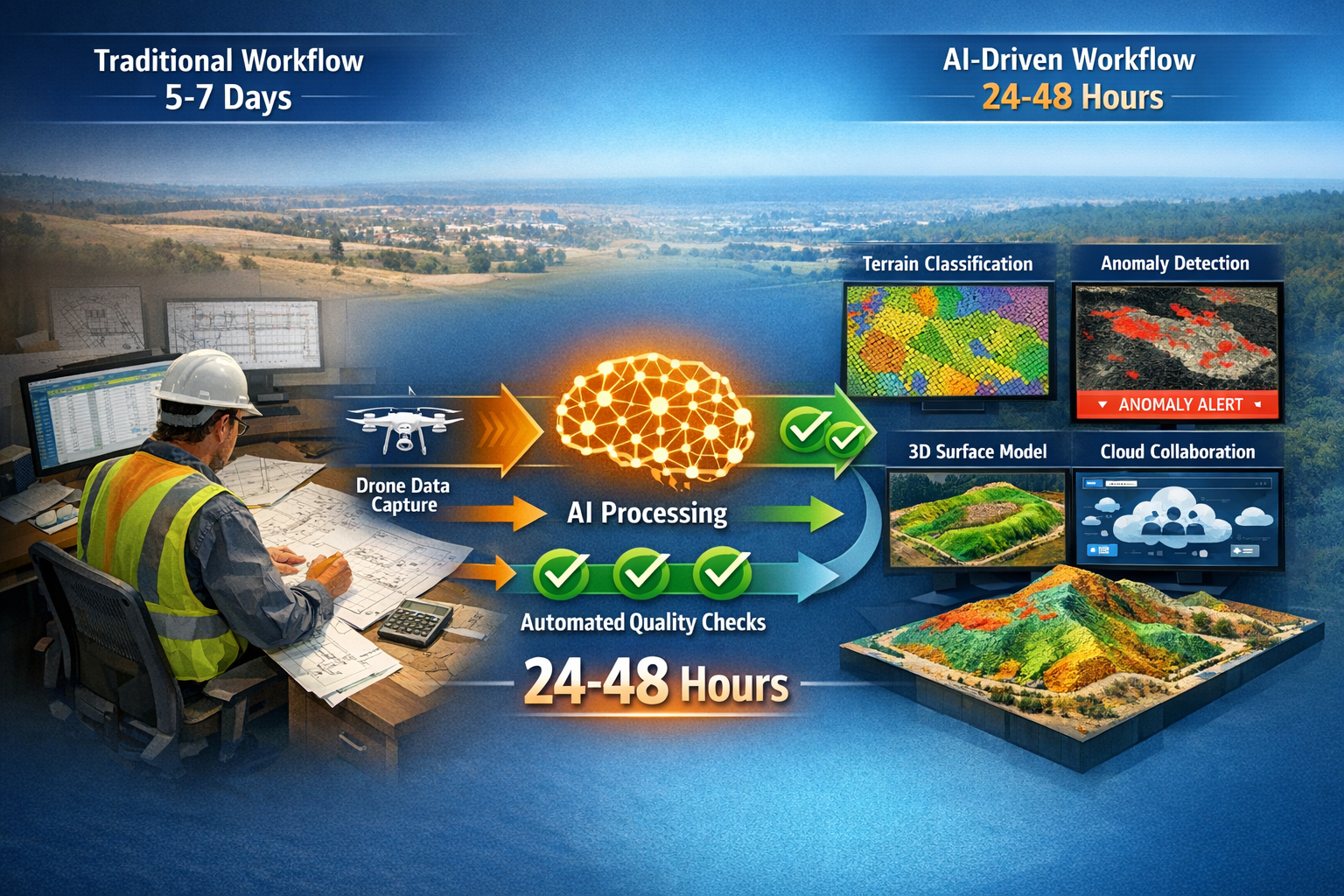
This manual approach consumed 60-70% of a surveyor's project time, leaving limited capacity for the high-value analytical work that truly serves clients. AI has fundamentally restructured this equation.
Today's AI-powered systems automatically classify terrain types, identify markers with computer vision algorithms, flag anomalies using pattern recognition, and generate preliminary surface models without human intervention.[1] This automation doesn't eliminate the surveyor's role—it elevates it by freeing professionals to focus on interpretation, quality assurance, and strategic consultation.
The Technology Stack Powering AI-Driven Surveying
Modern AI-driven surveying relies on an integrated technology ecosystem:
| Technology Component | Function | Impact on Workflow |
|---|---|---|
| Machine Learning Algorithms | Pattern recognition and classification | Automates terrain and feature identification |
| Computer Vision Systems | Visual data analysis and object detection | Identifies markers, boundaries, and structural elements |
| Neural Networks | Complex data relationship mapping | Detects anomalies and predicts potential issues |
| Cloud Computing Platforms | Data processing and storage | Enables real-time collaboration and massive dataset handling |
| LiDAR Integration | High-precision 3D scanning | Captures millions of elevation points for detailed modeling |
| Predictive Analytics | Forecasting and scenario modeling | Anticipates site behavior under various conditions |
This technology stack works in concert, creating a seamless workflow from data capture through final deliverable. When a surveying team deploys equipment on-site, the AI systems begin working immediately—processing incoming data streams, applying learned patterns from thousands of previous projects, and flagging items requiring human review.
Real-World Implementation: How Leading Firms Deploy AI
Haller & Blanchard's implementation provides a concrete example of AI integration in practice. Their workflow demonstrates how technology and human expertise complement each other:
Phase 1: Automated Data Capture and Processing
Field teams deploy multi-sensor equipment that feeds directly into AI processing systems. As data arrives, machine learning algorithms automatically classify ground cover, identify built structures, detect utilities, and flag potential survey markers—all without manual intervention.[1]
Phase 2: AI-Assisted Quality Control
The system runs automated quality checks, comparing captured data against expected patterns, identifying gaps in coverage, and highlighting areas requiring additional attention. These checks happen in real-time, allowing field teams to address issues before leaving the site.
Phase 3: Expert Surveyor Review and Validation
Professional surveyors review AI-processed data, applying their expertise to validate classifications, interpret ambiguous situations, and make final determinations on complex boundary issues. This is where professional judgment proves irreplaceable—recent testing confirms that AI-generated analyses, while comprehensive, frequently miss critical details that qualified surveyors immediately recognize.[2]
Phase 4: Client Deliverable Creation
AI systems generate preliminary reports and visualizations, which surveyors refine and customize based on client needs. The surveyor adds context, recommendations, and professional insights that transform raw data into actionable intelligence.
This workflow reduces total project time by 40-60% while actually improving accuracy through multiple automated quality checkpoints. More importantly, it allows surveyors to spend more time on activities that directly benefit clients: site analysis, risk assessment, and strategic consultation.
For property owners considering various types of surveys, understanding how AI enhances accuracy and efficiency helps set appropriate expectations for modern surveying services.
How AI-Driven Precision in Property Surveying Enhances Autonomous Drone Operations
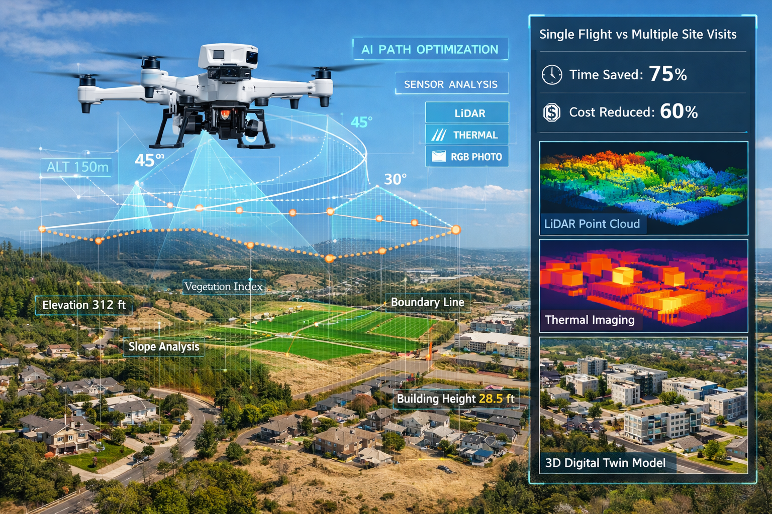
Drone technology has revolutionized property surveying, but the 2026 generation of autonomous multi-sensor drones represents a quantum leap beyond simple aerial photography. These systems combine advanced hardware with sophisticated AI algorithms that fundamentally change what's possible in a single site visit.
Predictive Flight Planning and Adaptive Sensor Selection
Traditional drone surveys required extensive pre-planning and often multiple flights to capture all necessary data. Operators manually programmed flight paths, selected sensor configurations, and hoped weather conditions cooperated. If data gaps emerged during processing, teams returned for additional flights—adding time and cost to projects.
AI-powered autonomous systems have eliminated these inefficiencies. Modern drones feature predictive modeling that automatically adjusts altitude, angle, and sensor selection to achieve optimal readings.[1] The system analyzes terrain complexity, lighting conditions, vegetation density, and project requirements to create the most efficient flight plan in real-time.
Consider a complex property survey involving:
- Residential structures requiring detailed roof and facade inspection
- Undeveloped land needing topographic mapping
- Wetland areas requiring vegetation classification
- Existing utilities needing precise location verification
A traditional approach might require four separate drone flights with different sensor configurations and flight parameters. An AI-driven autonomous system consolidates this into a single comprehensive flight that dynamically adjusts its approach as it encounters different terrain types and survey requirements.
Multi-Sensor Integration for Comprehensive Data Capture
Modern surveying drones carry multiple sensor types simultaneously:
- LiDAR sensors for high-precision elevation data
- High-resolution cameras for photogrammetry and visual documentation
- Thermal imaging for moisture detection and energy analysis
- Multispectral sensors for vegetation health and classification
The AI system doesn't just collect data from all sensors—it intelligently selects which sensors to prioritize based on what it encounters. When flying over dense vegetation, it emphasizes LiDAR to penetrate canopy. Over structures, it prioritizes high-resolution photography and thermal imaging. This adaptive approach maximizes data quality while minimizing flight time and battery consumption.
Real-Time Processing and Immediate Feedback
Perhaps the most significant advancement is real-time data processing during flight. AI systems analyze incoming data streams immediately, identifying:
- ✅ Areas with complete, high-quality coverage
- ⚠️ Zones requiring additional passes
- 🔍 Anomalies or features needing closer inspection
- 📊 Data quality metrics for each survey area
This immediate feedback allows the drone to autonomously adjust its flight plan while still airborne. If the system detects insufficient data density in a particular area, it automatically plans an additional pass before completing the mission. This self-correcting capability virtually eliminates the need for return visits due to data gaps.
For those wondering about the comprehensive nature of modern surveys, understanding these technological capabilities helps explain why a homebuyer survey can now provide unprecedented detail and accuracy.
Weather Adaptation and Risk Management
AI-enhanced drones incorporate sophisticated weather analysis and risk assessment. The systems monitor:
- Wind speed and direction at multiple altitudes
- Lighting conditions and shadow patterns
- Precipitation probability and intensity
- Temperature effects on sensor performance
When conditions begin degrading, the AI makes real-time decisions: adjust flight altitude to minimize wind impact, modify camera settings for changing light, or prioritize critical areas before weather deteriorates further. This intelligent adaptation maximizes productive flight time even in challenging conditions.
Case Study: Complex Commercial Property Survey
A recent commercial property survey illustrates these capabilities in action. The project involved a 15-acre mixed-use development site with:
- Existing structures scheduled for demolition
- Significant elevation changes (40+ feet)
- Dense vegetation in drainage areas
- Underground utilities requiring verification
- Adjacent properties requiring boundary documentation
Traditional approach: 3-4 separate site visits, multiple drone flights with different configurations, 5-7 days of data processing, potential return visits for data gaps.
AI-driven autonomous approach: Single 45-minute flight with adaptive sensor selection, real-time processing identifying complete coverage, preliminary 3D model available within 24 hours, final deliverables in 48 hours—representing an 80% reduction in timeline with improved data quality.
This efficiency transformation directly benefits property owners and developers who need reliable survey data quickly to maintain project schedules. When evaluating whether a survey is necessary when buying property, the speed and comprehensiveness of modern AI-enhanced surveys make them more accessible and valuable than ever.
AI-Driven Precision in Property Surveying Through Real-Time 3D Digital Twins
The concept of digital twins—virtual replicas of physical assets—has existed for years, but 2026 marks the year this technology became practical and accessible for property surveying. High-fidelity, interactive 3D models now update continuously as new data is collected, transforming how stakeholders interact with survey information.[1]
From Static Deliverables to Dynamic Collaboration Tools
Traditional surveying produced static outputs: PDF reports, 2D CAD drawings, and fixed 3D models that represented conditions at a specific moment. Any changes required creating entirely new deliverables. This approach worked adequately when projects moved slowly and stakeholder collaboration happened through periodic meetings.
Modern development timelines demand something different. Projects involve multiple parties—developers, architects, engineers, contractors, regulatory authorities—who need simultaneous access to current, accurate site information. Static documents create version control nightmares and communication gaps that delay decisions and increase costs.
Real-time 3D digital twins solve these challenges by providing a single source of truth that all stakeholders access simultaneously. When new survey data arrives—from additional drone flights, ground-penetrating radar scans, or utility locates—the digital twin updates automatically, ensuring everyone works from identical, current information.
Interactive Visualization and Scenario Modeling
Digital twins go far beyond simple 3D visualization. Modern systems allow users to:
Manipulate and Analyze
- Rotate, zoom, and section the model from any angle
- Toggle layers to view specific systems (utilities, topography, structures)
- Measure distances, areas, and volumes with precision
- Compare current conditions against historical data or proposed designs
Simulate Conditions
- Model water drainage under various rainfall scenarios
- Visualize sun exposure and shadow patterns throughout seasons
- Analyze sight lines and visual impact from different vantage points
- Test structural loads and soil stability under different conditions
Collaborate in Real-Time
- Multiple users view and annotate the same model simultaneously
- Video conferencing integrated directly into the 3D environment
- Decision tracking and comment threading tied to specific model locations
- Automated notifications when relevant model sections update
This shift from static deliverables to dynamic, collaborative tools represents one of the most significant changes in how surveying information serves project stakeholders.[1]
Continuous Updates and Living Documentation
Perhaps the most powerful aspect of digital twins is their ability to serve as living documentation throughout a property's lifecycle. Consider a large commercial development project:
Pre-Development Phase
Initial survey creates the baseline digital twin showing existing conditions, topography, utilities, and environmental features. Developers and architects use this to test site plan concepts and identify constraints.
Design Phase
Proposed structures and site improvements layer into the digital twin, allowing the team to visualize the project in context, identify conflicts with existing conditions, and optimize the design before construction begins.
Construction Phase
As-built conditions update the digital twin continuously. Contractors verify that construction matches design intent, and any field changes are immediately visible to all stakeholders.
Post-Construction Phase
The completed digital twin serves as a comprehensive as-built record for facility management, future renovations, and property transactions.
This continuous lifecycle approach provides exponentially more value than traditional point-in-time survey deliverables. Property owners possess a complete, accurate digital record that supports decision-making for years after the initial survey.
Cloud-Based Platforms Enabling Accessibility
The technology enabling real-time digital twins relies heavily on cloud infrastructure. Modern surveying platforms provide:
- Browser-based 3D visualization requiring no specialized software
- Instant file sharing with granular permission controls
- Real-time revision syncing across all user devices
- Integrated communication with threaded discussions tied to model locations
- Mobile access allowing field teams to reference models on-site
- API integration with other project management and design tools
This cloud-based approach democratizes access to sophisticated survey data. A property owner can review detailed site conditions from a tablet during a site walk. A regulatory reviewer can examine drainage patterns from their office. An engineer can verify utility locations while preparing construction documents—all accessing the same current, accurate model.
For those exploring comprehensive property assessments, understanding how digital twins enhance traditional surveying helps explain the value of services like a Level 3 home survey, which can now incorporate these advanced visualization capabilities.
Predictive Analytics and Property Intelligence
Digital twins become even more powerful when combined with AI-driven predictive analytics. The system can analyze the property model alongside external data sources to provide insights such as:
- Market value projections based on comparable properties and development trends
- Environmental risk assessment considering flood zones, soil conditions, and climate patterns
- Development potential analysis identifying optimal uses based on zoning, access, and market demand
- Infrastructure impact modeling showing how nearby development affects property value and usability
This property intelligence layer transforms surveying from documentation to strategic advisory. Surveyors provide not just measurements and observations, but actionable insights that inform investment decisions, development strategies, and risk management.
When property owners ask "is a homebuyers survey worth it," the answer in 2026 increasingly includes these advanced analytical capabilities that provide far more value than traditional inspection reports.
Quality Assurance and the Essential Role of Human Expertise
As AI capabilities expand, a critical question emerges: Can artificial intelligence replace professional surveyors? Recent testing and real-world implementation provide a definitive answer: No—but AI fundamentally enhances what surveyors can accomplish.
AI-Assisted Quality Checks in Review Pipelines
Leading surveying firms have integrated AI-assisted quality checks directly into their review pipelines, creating multiple verification layers that catch errors before deliverables reach clients.[1] These automated systems examine:
Data Completeness
- Coverage gaps in aerial or terrestrial scans
- Missing elevation points in critical areas
- Incomplete boundary documentation
- Gaps in utility location verification
Measurement Accuracy
- Consistency between multiple data sources
- Outlier detection in elevation models
- Closure errors in boundary surveys
- Dimensional verification against control points
Classification Consistency
- Terrain type classification accuracy
- Feature identification verification
- Material type consistency in structural surveys
- Vegetation classification validation
Regulatory Compliance
- Adherence to surveying standards and specifications
- Required documentation completeness
- Proper monument documentation
- Appropriate certification and sealing
These automated checks happen continuously throughout the project, not just at the end. This proactive quality assurance identifies issues while field crews remain on-site, allowing immediate correction rather than costly return visits.
The Irreplaceable Value of Professional Judgment
Despite impressive AI capabilities, recent testing by surveying consultants reveals critical limitations. As documented in January 2026, AI-generated summaries and analyses frequently omit important details that qualified surveyors immediately recognize.[2]
Testing involved submitting complex survey scenarios to advanced AI systems and comparing outputs against professional surveyor analysis. The results were revealing:
AI Strengths:
- ✅ Organizing large volumes of information efficiently
- ✅ Identifying obvious patterns and anomalies
- ✅ Performing calculations with perfect accuracy
- ✅ Generating comprehensive preliminary reports
- ✅ Maintaining consistency across similar tasks
AI Limitations:
- ❌ Missing subtle but critical details in complex situations
- ❌ Failing to recognize context-dependent implications
- ❌ Overlooking important provisions in legal documents
- ❌ Inability to apply professional judgment to ambiguous conditions
- ❌ Lack of understanding regarding practical construction implications
One particularly instructive example involved a boundary dispute where AI analysis appeared thorough and comprehensive. However, professional review identified that the AI had completely missed a critical easement provision buried in historical deed language—an oversight that could have resulted in significant legal and financial consequences for the client.[2]
Document Review and Interpretation Challenges
Practical field testing shows AI systems excel at organizing information but struggle with interpretation. When reviewing lease agreements, property reports, and historical documentation, AI tools effectively:
- Extract key dates, parties, and numerical data
- Organize information into logical categories
- Identify standard clauses and provisions
- Flag unusual or non-standard language
However, these same systems miss critical provisions that experienced surveyors recognize as significant.[2] The AI might identify that an easement exists but fail to understand its practical implications for property use, development potential, or boundary determination.
This limitation isn't a temporary technology gap—it reflects the fundamental difference between pattern recognition and professional expertise. Surveyors bring:
- Contextual understanding of local regulations, market conditions, and construction practices
- Professional experience recognizing how site conditions affect property use and value
- Ethical judgment balancing competing interests and regulatory requirements
- Communication skills translating technical findings into actionable client guidance
- Legal awareness understanding the implications of survey findings for property rights and disputes
The Optimal Human-AI Partnership
The most effective approach combines AI efficiency with human expertise. Modern surveying workflows allocate tasks based on comparative advantage:
AI Handles:
- Repetitive data processing and classification
- Mathematical calculations and geometric analysis
- Pattern recognition across large datasets
- Preliminary quality checks and consistency verification
- Report formatting and standard documentation
Surveyors Focus On:
- Complex interpretation requiring professional judgment
- Client consultation and needs assessment
- Ambiguous situations requiring contextual understanding
- Final quality assurance and professional certification
- Strategic recommendations and risk assessment
This division of labor allows surveyors to complete more projects at higher quality levels while maintaining the professional standards that protect public safety and property rights.
For complex situations like party wall surveys, where legal, technical, and interpersonal considerations intersect, the combination of AI efficiency and professional expertise proves particularly valuable.
Continuing Professional Development in the AI Era
The integration of AI into surveying workflows creates new professional development requirements. Modern surveyors must understand:
- How to effectively supervise and validate AI-generated outputs
- Which tasks are appropriate for AI automation versus requiring human judgment
- How to communicate AI capabilities and limitations to clients
- When to override AI recommendations based on professional expertise
- How to integrate AI tools into quality management systems
Professional organizations and regulatory bodies are updating standards and continuing education requirements to address these needs. The surveyor's role hasn't diminished—it has evolved to incorporate new tools while maintaining the professional judgment that defines the profession.
Market Impact and Property Valuation Applications
Beyond technical surveying applications, AI is transforming property valuation and market analysis in ways that directly affect property owners, investors, and developers. The integration of AI-driven precision in property surveying with advanced valuation algorithms creates unprecedented analytical capabilities.
Algorithmic Property Valuation Enhancement
Traditional property valuation relied heavily on comparable sales analysis and appraiser judgment. While effective, this approach had limitations:
- Time-intensive manual research and analysis
- Limited number of comparable properties considered
- Difficulty adjusting for unique property characteristics
- Lag time between market shifts and valuation updates
- Variability based on individual appraiser expertise
AI systems now analyze thousands of data points simultaneously, including local market trends, school ratings, traffic patterns, business activity, and countless other factors to estimate property values with improved accuracy.[3] These systems don't replace professional appraisers but provide them with more comprehensive data and preliminary analysis.
The AI valuation process incorporates:
Traditional Factors
- Recent comparable sales with sophisticated similarity scoring
- Property characteristics (size, age, condition, features)
- Location attributes (neighborhood, proximity to amenities)
- Historical price trends and appreciation patterns
Advanced Data Sources
- Real-time market activity and inventory levels
- Economic indicators (employment, income, business growth)
- Infrastructure development and transportation improvements
- Environmental factors (flood risk, air quality, noise levels)
- Social metrics (crime rates, school performance, demographic trends)
- Future development plans and zoning changes
This comprehensive analytical approach provides more accurate valuations, particularly for unique properties where traditional comparable sales analysis struggles.
Predictive Market Analysis for Investment Decisions
Perhaps more valuable than current valuation is predictive analysis forecasting future market movements. AI algorithms analyze live signals including rental demand, local job growth, new construction activity, and consumer behavior shifts to forecast market trends.[3]
This predictive capability helps investors identify high-yield neighborhoods before traditional reports detect trends. The system might recognize patterns such as:
- Increasing rental demand in specific submarkets
- Business development indicating job growth
- Infrastructure improvements enhancing accessibility
- Demographic shifts suggesting changing property needs
- Early indicators of gentrification or neighborhood transition
For property investors and developers, this intelligence provides significant competitive advantage. Decisions about acquisitions, development timing, and property positioning can incorporate forward-looking analysis rather than relying solely on historical trends.
The $110-180 Billion Opportunity
The scale of AI's impact on real estate becomes clear when examining industry projections. McKinsey estimates place the potential annual value generation from AI applications in the U.S. real estate market at $110-180 billion.[6] This massive figure reflects AI's influence across multiple real estate functions:
| Application Area | Value Creation Mechanism | Estimated Impact |
|---|---|---|
| Property Valuation | More accurate pricing, reduced time to value | $15-25 billion |
| Market Analysis | Better investment decisions, risk reduction | $25-35 billion |
| Transaction Efficiency | Faster closings, reduced costs | $20-30 billion |
| Property Management | Optimized operations, predictive maintenance | $30-50 billion |
| Development Planning | Better site selection, design optimization | $20-30 billion |
For surveying professionals, this transformation creates both opportunities and imperatives. Firms that effectively integrate AI capabilities position themselves to capture more value by offering enhanced analytical services. Those that resist technological adoption risk losing relevance as client expectations evolve.
Commercial Property Applications
AI-driven precision proves particularly valuable in commercial property contexts where survey accuracy directly impacts financial decisions. Commercial property surveyors now provide clients with:
Enhanced Due Diligence
- Comprehensive site analysis identifying development constraints and opportunities
- Predictive modeling showing property performance under various scenarios
- Market positioning analysis based on competitive properties and demographic trends
- Risk assessment incorporating environmental, regulatory, and market factors
Development Optimization
- Site utilization analysis maximizing building efficiency and value
- Infrastructure impact modeling showing how improvements affect property value
- Phasing analysis identifying optimal development sequencing
- Market timing recommendations based on predictive analytics
Portfolio Management
- Comparative property analysis across large portfolios
- Performance benchmarking against market standards
- Predictive maintenance scheduling based on building condition trends
- Disposition timing recommendations optimizing exit strategies
This expanded analytical capability transforms surveying from a compliance requirement into a strategic advisory service that directly influences investment returns.
Future Developments and Industry Transformation
As 2026 progresses, several significant developments promise to further accelerate AI integration in property surveying. Understanding these emerging trends helps property owners, investors, and industry professionals prepare for continued transformation.
Trimble AI Studio and Platform Evolution
One of the most anticipated developments is Trimble AI Studio, scheduled for early 2026 launch.[7] While full details remain limited, industry insiders expect this platform to provide:
- Unified AI-powered workflow management for surveying firms
- Automated project planning and resource allocation
- Integrated quality assurance across all project phases
- Client collaboration portals with real-time project visibility
- Predictive analytics for project timelines and resource requirements
This type of comprehensive platform represents the next evolution beyond point solutions. Rather than separate AI tools for specific tasks, integrated platforms will manage entire project lifecycles with AI assistance at every stage.
Building Information Modeling (BIM) Integration Acceleration
BIM integration continues gaining traction as land surveyors increasingly collaborate with architects and engineers to integrate geospatial data into comprehensive building models.[1] This integration creates:
Design Phase Benefits
- Accurate existing conditions modeling reducing design conflicts
- Terrain and utility data informing foundation and infrastructure design
- Environmental constraints integrated into early planning
- Regulatory compliance verification before detailed design
Construction Phase Advantages
- As-built verification against design intent
- Real-time progress tracking and documentation
- Conflict detection between design and field conditions
- Change order documentation and impact analysis
Facility Management Value
- Comprehensive as-built documentation for ongoing operations
- Maintenance planning based on accurate facility information
- Renovation planning with complete existing condition data
- Space management and optimization analytics
The combination of AI-driven surveying and BIM creates a continuous digital thread from initial site analysis through building operation, fundamentally changing how the built environment is planned, constructed, and managed.
Regulatory and Standards Evolution
As AI becomes integral to surveying workflows, regulatory bodies and professional organizations are updating standards and requirements. Key developments include:
Quality Assurance Standards
- Guidelines for AI system validation and verification
- Requirements for human review of AI-generated outputs
- Documentation standards for AI-assisted workflows
- Professional liability considerations for AI-enhanced services
Professional Competency Requirements
- Continuing education on AI capabilities and limitations
- Certification programs for AI tool proficiency
- Ethical guidelines for AI application in surveying
- Client communication standards regarding AI use
Data Management Regulations
- Privacy protections for property and personal data
- Cybersecurity requirements for cloud-based platforms
- Data retention and archival standards
- Cross-border data transfer regulations
These evolving standards ensure that AI integration enhances rather than compromises professional standards that protect public safety and property rights.
Emerging Applications and Use Cases
Beyond current applications, several emerging use cases demonstrate AI's expanding role:
Climate Resilience Planning
- Long-term environmental risk modeling
- Sea level rise and flood risk projections
- Extreme weather impact analysis
- Adaptation strategy development
Smart City Integration
- Real-time infrastructure monitoring
- Traffic pattern analysis and optimization
- Utility network management and planning
- Public space utilization analytics
Sustainability Assessment
- Energy efficiency analysis and optimization
- Green infrastructure planning and performance
- Carbon footprint calculation and reduction strategies
- Sustainable development impact assessment
Historical Preservation
- Detailed documentation of historic structures
- Condition monitoring and deterioration prediction
- Restoration planning and verification
- Virtual preservation and public access
These applications demonstrate how AI-driven surveying extends beyond traditional property assessment into broader urban planning, environmental management, and cultural preservation domains.
For property owners navigating these changes, understanding modern surveying capabilities helps when determining what survey you need for specific property decisions.
Practical Considerations for Property Owners and Stakeholders

Understanding how AI transforms surveying workflows helps property owners make informed decisions about when to commission surveys, what to expect from modern surveying services, and how to maximize value from survey investments.
When AI-Enhanced Surveying Provides Maximum Value
Certain property situations particularly benefit from AI-driven precision in property surveying:
Complex Site Conditions
- Properties with significant topographic variation
- Sites with dense vegetation or difficult access
- Large acreage requiring comprehensive documentation
- Properties with multiple structures or improvements
- Sites with known or suspected environmental concerns
Time-Sensitive Transactions
- Commercial acquisitions with tight due diligence timelines
- Development projects with critical path schedules
- Refinancing requiring rapid property assessment
- Dispute resolution needing quick, accurate documentation
High-Value Decisions
- Major development or redevelopment projects
- Significant property investments
- Complex boundary or easement determinations
- Properties with substantial improvement potential
Ongoing Management Needs
- Large portfolios requiring periodic assessment
- Properties with changing conditions (construction, erosion, development)
- Facilities needing comprehensive as-built documentation
- Assets requiring continuous monitoring and analysis
For these situations, the speed, accuracy, and analytical depth of AI-enhanced surveying provides substantial value that justifies the investment.
Questions to Ask When Commissioning Surveys
Property owners should understand how surveying firms integrate AI into their workflows:
Technology and Capabilities
- What AI tools and platforms does your firm use?
- How do you validate AI-generated outputs?
- What quality assurance processes ensure accuracy?
- Can you provide real-time project updates through digital platforms?
Deliverables and Access
- What format will survey deliverables take?
- Will I receive access to interactive 3D models or digital twins?
- How long will I have access to cloud-based platforms?
- Can the survey data integrate with my architect's or engineer's systems?
Professional Oversight
- What level of professional surveyor review occurs?
- How do you balance AI automation with human expertise?
- What professional certifications and insurance do you maintain?
- How do you handle situations where AI and professional judgment differ?
Timeline and Process
- How does AI integration affect project timelines?
- What site access and preparation do you require?
- How do weather or site conditions affect scheduling?
- What happens if additional data collection becomes necessary?
These questions help ensure you're working with a firm that effectively leverages technology while maintaining professional standards.
Cost Considerations and Value Assessment
AI-enhanced surveying often provides better value despite potentially higher initial costs. Consider the total value equation:
Traditional Surveying Costs:
- Lower initial fee
- Longer timeline (5-7 days typical)
- Static deliverables with limited reuse value
- Potential for return visits if data gaps emerge
- Limited analytical depth beyond basic measurements
AI-Enhanced Surveying Value:
- Potentially higher initial investment
- Dramatically shorter timeline (24-48 hours possible)
- Interactive deliverables with ongoing utility
- Comprehensive single-visit data capture
- Advanced analytics supporting decision-making
For time-sensitive situations or complex properties, the compressed timeline alone often justifies premium pricing. When you factor in enhanced accuracy, comprehensive documentation, and analytical capabilities, AI-enhanced surveying frequently provides superior value.
When evaluating whether you need a survey when buying a house, consider both immediate transaction needs and long-term property management value.
Preparing for Your Survey
Maximize survey value by preparing appropriately:
Before the Survey:
- Gather existing documentation (previous surveys, title reports, improvement records)
- Identify specific questions or concerns you need addressed
- Provide access to all property areas including restricted spaces
- Notify tenants or occupants about survey activities
- Mark known underground utilities or sensitive areas
During the Survey:
- Designate a contact person for surveyor questions
- Keep pets secured and away from survey areas
- Avoid moving or disturbing survey equipment
- Document any recent changes or improvements
- Ask questions about the process and preliminary observations
After the Survey:
- Review deliverables thoroughly with your surveyor
- Ask for clarification on any unclear findings
- Understand how to access and use digital platforms
- Retain survey data for future reference and projects
- Share relevant findings with other professionals (architects, engineers, attorneys)
Proper preparation and engagement ensure you receive maximum value from your survey investment.
Conclusion: Embracing the AI-Powered Future of Property Surveying
AI-Driven Precision in Property Surveying: How Artificial Intelligence is Revolutionizing Workflows in 2026 represents far more than technological novelty—it marks a fundamental transformation in how surveying professionals serve clients and how property stakeholders make informed decisions. The integration of artificial intelligence into core surveying workflows has moved beyond experimental applications to become essential infrastructure within leading practices.
The Transformation in Perspective
The changes documented throughout this article demonstrate several clear realities:
🚀 Speed and Efficiency Gains Are Real
AI automation reduces project timelines by 40-80% while improving accuracy through multiple automated quality checkpoints. What required weeks now happens in days or even hours.
🎯 Accuracy and Comprehensiveness Improve
Multi-sensor autonomous drones, real-time processing, and AI-assisted quality checks create more complete, accurate documentation than traditional manual methods.
🤝 Human Expertise Remains Essential
Despite impressive AI capabilities, professional surveyor judgment proves irreplaceable for complex interpretation, ambiguous situations, and client consultation.
💡 Value Extends Beyond Documentation
Real-time 3D digital twins, predictive analytics, and comprehensive property intelligence transform surveying from compliance documentation to strategic advisory services.
📈 Industry-Wide Transformation Continues
With $110-180 billion in potential annual value creation, AI's impact on real estate and surveying will only accelerate in coming years.
Actionable Next Steps for Property Stakeholders
For Property Owners:
- When commissioning surveys, ask about AI capabilities and how they enhance deliverables
- Request access to interactive 3D models and digital platforms that provide ongoing value
- Ensure your surveyor balances AI efficiency with professional expertise and oversight
- Retain digital survey data as a valuable asset for future property decisions
- Consider how AI-enhanced surveys support both immediate needs and long-term property management
For Real Estate Investors:
- Leverage predictive analytics and market intelligence from AI-enhanced surveys
- Use comprehensive digital twins for due diligence and development planning
- Factor reduced survey timelines into transaction schedules and competitive strategies
- Explore how ongoing access to survey platforms supports portfolio management
- Stay informed about emerging AI capabilities that create competitive advantages
For Development Professionals:
- Integrate AI-driven surveying early in project planning for maximum value
- Utilize real-time collaboration platforms to coordinate with all project stakeholders
- Leverage BIM integration to create seamless workflows from survey through construction
- Use predictive modeling and scenario analysis to optimize project design and phasing
- Build relationships with surveying firms that effectively balance technology and expertise
For Surveying Professionals:
- Invest in AI tools and platforms that enhance efficiency while supporting professional judgment
- Develop competencies in AI system supervision, validation, and effective deployment
- Communicate clearly with clients about how AI enhances your services
- Maintain focus on high-value professional activities that AI cannot replicate
- Stay current with evolving standards, regulations, and best practices for AI integration
The Path Forward
The surveying profession stands at an inflection point. Firms that effectively integrate AI-driven precision in property surveying while maintaining professional standards will thrive, offering clients unprecedented speed, accuracy, and analytical depth. Those that resist technological evolution risk losing relevance as client expectations shift.
For property owners and stakeholders, this transformation creates opportunities to make better-informed decisions based on more comprehensive, accurate, and timely information. The key is working with professionals who leverage technology effectively while providing the expert judgment and client service that define exceptional surveying practice.
As 2026 progresses and AI capabilities continue expanding, one principle remains constant: technology serves as a powerful tool, but professional expertise, ethical judgment, and client service define value in property surveying. The future belongs to those who embrace both—using AI to enhance efficiency and capabilities while maintaining the professional standards that protect public safety, property rights, and client interests.
Whether you're purchasing a home, developing commercial property, managing a large portfolio, or simply seeking to understand your property better, AI-enhanced surveying provides tools and insights that were simply impossible just a few years ago. The question isn't whether to embrace this transformation—it's how to leverage it most effectively for your specific needs and objectives.
The revolution in property surveying workflows is here. The professionals and property stakeholders who understand and embrace AI-driven precision will be best positioned to succeed in this new era of unprecedented capability and insight.
References
[1] Future Land Surveying 2026 – https://haller-blanchard.com/future-land-surveying-2026/
[2] How Ai Is Changing Building Surveying Opportunities And Limitations – https://www.eddisons.com/insights/how-ai-is-changing-building-surveying-opportunities-and-limitations
[3] How Ai Is Changing Real Estate In The Usa – https://www.rentana.io/blog/how-ai-is-changing-real-estate-in-the-usa
[6] Best Ai Tools For Real Estate – https://www.v7labs.com/blog/best-ai-tools-for-real-estate
[7] How Ai Is Changing The Role Of The Surveyor In Aec – https://www.gim-international.com/content/article/how-ai-is-changing-the-role-of-the-surveyor-in-aec