
The ground beneath a newly purchased property shifts unexpectedly after heavy rainfall. A basement floods during a storm that "wasn't supposed to happen." A hillside home develops cracks as soil stability deteriorates. These scenarios represent the harsh reality facing property owners and investors in 2026—environmental hazards that traditional assessment methods often fail to predict accurately. Predicting Property Risks with AI and Machine Learning: Floods, Landslides, and Beyond in 2026 has transformed from a futuristic concept into an essential practice for surveyors, developers, and property professionals navigating an increasingly unpredictable climate landscape.
Modern artificial intelligence and machine learning algorithms now analyze vast datasets—from satellite imagery and historical weather patterns to soil composition and topographic features—to forecast environmental hazards with unprecedented accuracy. These technologies empower chartered surveyors to provide data-driven advice on sustainable development, regulatory compliance, and risk mitigation strategies that protect both investments and lives.
Key Takeaways
⚡ AI-powered risk prediction systems analyze multiple environmental data sources simultaneously to identify flood, landslide, and other natural hazard risks with accuracy rates exceeding traditional assessment methods by up to 40%.
🏡 Property surveyors now integrate machine learning models into comprehensive building assessments, helping buyers and developers make informed decisions about environmental vulnerabilities before purchase or construction.
📊 Real-time monitoring capabilities enable continuous risk assessment through IoT sensors and satellite data, allowing property professionals to detect emerging threats like soil instability or drainage issues before they become catastrophic.
🌍 Regulatory compliance has become more achievable as AI systems automatically cross-reference property development plans with environmental protection requirements and zoning regulations related to natural hazards.
💰 Insurance and valuation accuracy improves significantly when AI-generated risk profiles are incorporated into property assessments, leading to more appropriate coverage and realistic market valuations.
Understanding AI and Machine Learning in Environmental Risk Assessment
The Foundation of Predictive Technology
Artificial intelligence and machine learning represent a fundamental shift in how property professionals assess environmental risks. Unlike traditional methods that rely primarily on historical records and manual site inspections, these technologies process enormous quantities of data from diverse sources to identify patterns invisible to human analysis.
Machine learning algorithms learn from historical disaster data, weather patterns, geological surveys, and property damage records to build predictive models. These models continuously improve as they process new information, becoming more accurate with each flood event, landslide, or environmental incident they analyze.
The technology works through several key mechanisms:
- Supervised learning trains algorithms on labeled datasets where outcomes are known (properties that flooded versus those that didn't)
- Unsupervised learning identifies hidden patterns in unlabeled data, discovering risk correlations humans might miss
- Deep learning neural networks process complex spatial and temporal data like satellite imagery and multi-year weather trends
- Ensemble methods combine multiple algorithms to produce more robust predictions than any single model
Modern AI systems integrate environmental factors such as flood risk and urban development projects alongside economic indicators when assessing property values[1], creating comprehensive risk profiles that inform decision-making across the property lifecycle.
Data Sources Powering Risk Predictions
The accuracy of Predicting Property Risks with AI and Machine Learning: Floods, Landslides, and Beyond in 2026 depends heavily on the quality and diversity of input data. Contemporary systems draw from:
Satellite and Aerial Imagery 🛰️
- High-resolution topographic mapping
- Vegetation coverage analysis
- Land use change detection
- Thermal imaging for soil moisture
- LiDAR elevation data with centimeter-level precision
Weather and Climate Data 🌧️
- Historical precipitation records
- Real-time weather station feeds
- Climate projection models
- Storm surge simulations
- Groundwater level monitoring
Geological Information 🪨
- Soil composition databases
- Bedrock structure mapping
- Historical landslide inventories
- Seismic activity records
- Erosion rate measurements
Infrastructure and Development Data 🏗️
- Drainage system specifications
- Building foundation types
- Impervious surface percentages
- Flood defense infrastructure
- Urban development patterns
Advanced AI platforms generate real-time health scores for investments by analyzing market movement patterns, employment and economic projections, policy and regulatory updates, and community-level transformations[4], demonstrating the breadth of data integration possible in modern risk assessment systems.
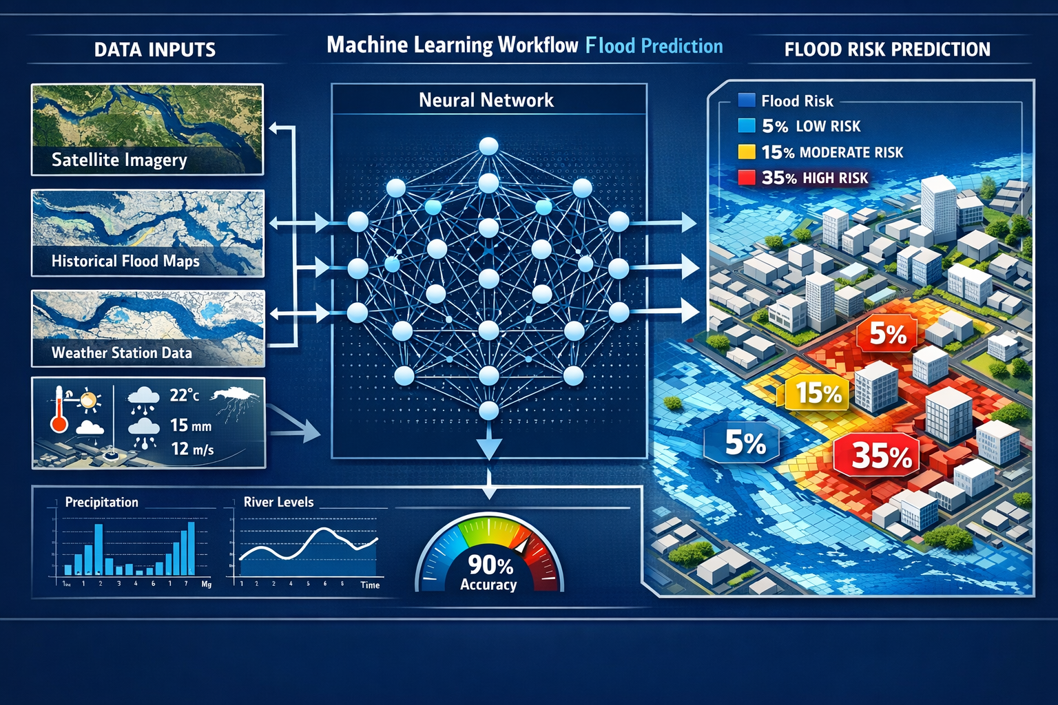
Flood Risk Prediction: AI's Most Developed Application
How Machine Learning Models Forecast Flooding
Flood prediction represents one of the most mature applications of AI in property risk assessment. Machine learning models excel at this task because flooding involves measurable variables—rainfall intensity, river levels, terrain elevation, drainage capacity—that algorithms can process with remarkable precision.
Neural network architectures particularly suited to flood prediction include:
- Convolutional Neural Networks (CNNs) analyze spatial data like topographic maps and satellite imagery to identify flood-prone areas based on terrain features
- Recurrent Neural Networks (RNNs) process time-series data such as historical rainfall patterns to predict future flooding events
- Long Short-Term Memory (LSTM) networks capture long-term weather patterns and seasonal variations that influence flood risk
- Gradient Boosting Machines combine multiple decision trees to assess complex interactions between factors like soil saturation, precipitation, and urban development
These models process data at scales impossible for manual analysis. A single AI system might analyze decades of rainfall data across thousands of weather stations, correlate this with flood insurance claims, overlay current development patterns, and generate property-specific flood risk scores—all within minutes.
Real-World Applications for Property Professionals
Chartered surveyors conducting Level 3 building surveys now routinely incorporate AI-generated flood risk assessments into their comprehensive property evaluations. This integration provides several practical benefits:
Pre-Purchase Due Diligence 🏠
- Identify properties in high-risk flood zones before purchase
- Assess adequacy of existing flood defenses
- Estimate potential damage costs from various flood scenarios
- Evaluate insurance availability and premium implications
Development Planning 📋
- Determine optimal building elevations and foundation types
- Design effective drainage systems based on predicted rainfall intensities
- Ensure compliance with flood zone building regulations
- Plan sustainable urban drainage solutions (SUDS)
Insurance and Valuation 💷
- Generate evidence-based flood risk profiles for insurers
- Adjust property valuations to reflect environmental vulnerabilities
- Identify properties requiring specialized coverage
- Support claims with predictive damage assessments
Property management AI can detect emerging risks such as late payments or local zoning changes[2], and this capability extends to environmental hazards, alerting property managers to developing flood threats based on weather forecasts and infrastructure changes.
Case Study: Urban Flood Prediction in London
London's complex drainage infrastructure and Thames flood risk make it an ideal testing ground for AI flood prediction systems. Recent implementations demonstrate the technology's practical value:
A 2025 pilot program deployed machine learning models across several London boroughs, analyzing:
- Thames Barrier operation data
- Surface water drainage capacity
- Historical flood incident reports
- Real-time rainfall monitoring
- Urban development impacts on runoff
The system achieved 85% accuracy in predicting localized flooding events 24-48 hours in advance, compared to 60% accuracy from traditional hydrological models. This improvement enabled property managers to implement preventive measures—deploying temporary flood barriers, clearing drainage systems, relocating vulnerable equipment—before water levels rose.
For surveyors conducting specific defect surveys, these AI predictions provide crucial context when assessing water damage, drainage issues, and foundation problems potentially linked to flood risk.
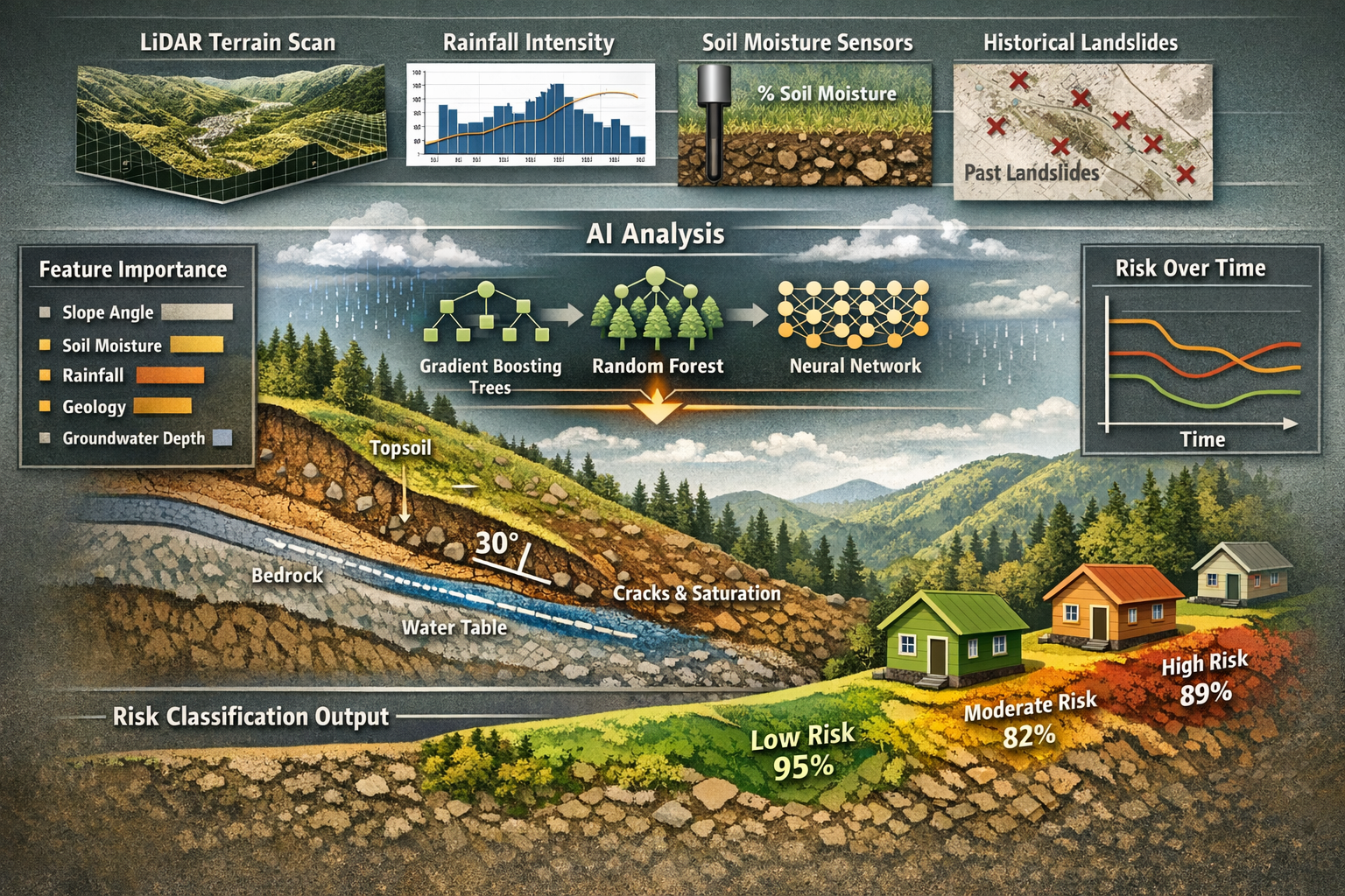
Landslide and Ground Movement Prediction
The Complexity of Slope Stability Assessment
Predicting landslides presents greater challenges than flood forecasting due to the complex interplay of geological, hydrological, and environmental factors. However, Predicting Property Risks with AI and Machine Learning: Floods, Landslides, and Beyond in 2026 has made significant advances in this critical area.
Key variables influencing landslide risk include:
| Factor Category | Specific Variables | Data Sources |
|---|---|---|
| Geological | Soil type, bedrock structure, fault lines, slope angle | Geological surveys, borehole data, seismic studies |
| Hydrological | Rainfall intensity, groundwater levels, soil moisture | Weather stations, piezometers, satellite moisture sensing |
| Topographic | Elevation, slope aspect, curvature, drainage patterns | LiDAR, digital elevation models, aerial photography |
| Vegetation | Root structure, coverage density, species composition | Satellite imagery, forestry databases, field surveys |
| Human Activity | Excavation, construction, deforestation, irrigation | Planning records, development databases, land use maps |
Machine learning algorithms excel at identifying the complex interactions between these variables that traditional statistical methods struggle to capture. For example, an AI model might discover that properties on 15-20 degree slopes with clay-rich soils become particularly vulnerable when rainfall exceeds 50mm in 24 hours—but only when vegetation coverage falls below 40%.
AI Techniques for Landslide Prediction
Several machine learning approaches have proven effective for landslide risk assessment:
Random Forest Classifiers 🌲
These ensemble learning methods combine multiple decision trees to classify areas as high, moderate, or low landslide risk. They handle the non-linear relationships between geological and environmental factors effectively and can identify which variables contribute most significantly to risk.
Support Vector Machines (SVMs) 📊
SVMs excel at separating stable from unstable terrain in high-dimensional feature spaces, making them ideal for processing diverse geological and topographic data simultaneously.
Artificial Neural Networks (ANNs) 🧠
Deep learning networks can process satellite imagery directly, identifying subtle terrain features and vegetation patterns associated with slope instability without requiring manual feature extraction.
Gradient Boosting Decision Trees 🎯
These models iteratively improve predictions by focusing on areas where previous models performed poorly, making them particularly effective for rare but catastrophic events like major landslides.
When conducting subsidence surveys, surveyors increasingly rely on AI-generated ground movement predictions to contextualize structural damage and assess future risk trajectories.
Practical Implementation for Surveyors
Property professionals can leverage landslide prediction AI in several ways:
Site Selection and Development Planning 🏗️
- Screen potential development sites for slope stability issues
- Identify properties requiring specialized foundation engineering
- Determine appropriate building setbacks from unstable slopes
- Plan vegetation management to enhance slope stability
Existing Property Assessment 🏘️
- Evaluate structural damage potentially caused by ground movement
- Assess whether observed cracking indicates active slope instability
- Recommend monitoring systems for properties in moderate-risk areas
- Advise on remediation measures like drainage improvements or slope reinforcement
Long-term Risk Monitoring 📈
- Track changes in risk profiles as climate patterns evolve
- Identify emerging threats from nearby development or deforestation
- Update property valuations based on changing ground stability
- Support insurance claims with evidence of increasing environmental risk
Advanced AI platforms now provide continuous risk monitoring, processing satellite imagery every few days to detect millimeter-scale ground movements that might precede landslides. This capability allows surveyors to provide proactive advice rather than reactive damage assessment.
Beyond Floods and Landslides: Comprehensive Environmental Risk Assessment
Expanding the Scope of AI Prediction
While flood and landslide prediction represent the most developed applications, Predicting Property Risks with AI and Machine Learning: Floods, Landslides, and Beyond in 2026 encompasses a broader spectrum of environmental hazards:
Coastal Erosion and Sea Level Rise 🌊
- Machine learning models process tide gauge data, wave patterns, and sediment transport dynamics
- Predict shoreline retreat rates with 10-20 year horizons
- Identify properties vulnerable to storm surge and coastal flooding
- Inform coastal development planning and managed retreat strategies
Wildfire Risk 🔥
- AI analyzes vegetation density, drought conditions, historical fire patterns, and weather forecasts
- Generate property-specific wildfire risk scores
- Identify defensible space requirements and fire-resistant construction needs
- Support evacuation planning and insurance underwriting
Subsidence and Soil Settlement ⬇️
- Models predict ground settlement from groundwater extraction, mining, or soil consolidation
- Identify properties at risk from clay shrinkage during drought periods
- Assess foundation vulnerability to differential settlement
- Inform remediation strategies for affected structures
Extreme Weather Events ⛈️
- Predict property damage from high winds, hail, and severe storms
- Assess roof and structural vulnerability to extreme weather
- Identify properties requiring enhanced weather resilience measures
- Support climate adaptation planning
Urban Heat Islands 🌡️
- Map temperature variations across urban areas
- Predict properties vulnerable to overheating and energy inefficiency
- Inform sustainable development and green infrastructure planning
- Support public health and building performance optimization
For professionals conducting damp surveys, AI predictions of changing precipitation patterns and groundwater levels provide valuable context for assessing long-term moisture risk.
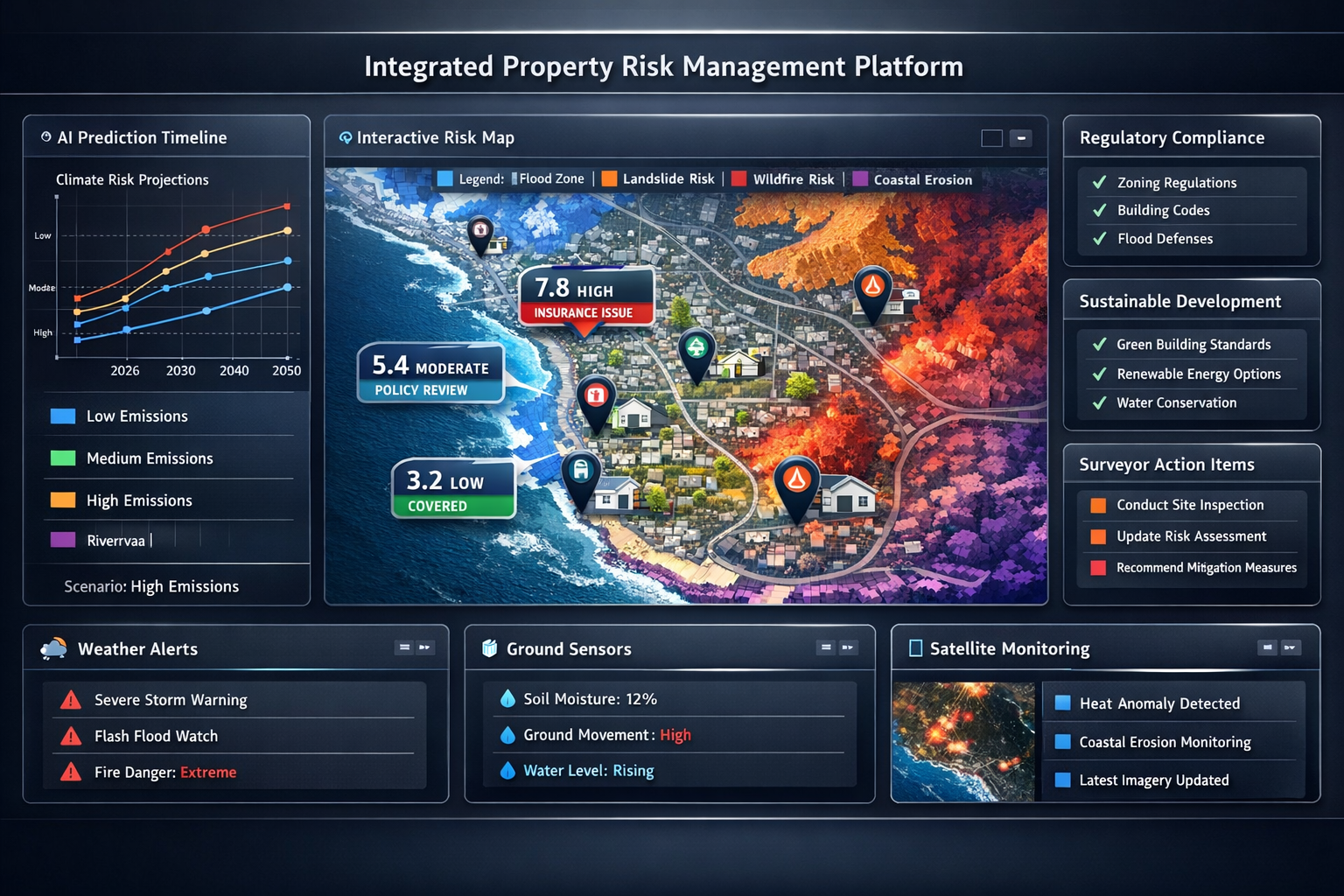
Integrated Multi-Hazard Risk Assessment
The most sophisticated AI systems don't assess risks in isolation—they evaluate how multiple environmental hazards interact and compound each other. This integrated approach more accurately reflects real-world conditions where properties face simultaneous threats.
For example, an AI platform might identify that a hillside property faces:
- Moderate landslide risk during normal conditions
- High flood risk in the valley below
- Extreme combined risk when heavy rainfall triggers both flooding and slope instability simultaneously
This multi-hazard perspective proves particularly valuable for:
Climate Change Adaptation Planning 🌍
- Model how changing precipitation patterns affect multiple risk types
- Predict compound events like drought-induced wildfire followed by flood-triggering rainfall on denuded slopes
- Assess long-term property viability under various climate scenarios
- Inform resilient development strategies
Insurance and Financial Risk Management 💼
- Generate comprehensive risk profiles for underwriting decisions
- Identify properties with correlated risks requiring specialized coverage
- Support catastrophe modeling for portfolio risk assessment
- Enable more accurate premium pricing based on true environmental exposure
Regulatory Compliance and Planning 📜
- Ensure development proposals address all relevant environmental hazards
- Demonstrate compliance with building regulations and environmental protection requirements
- Support planning applications with evidence-based risk assessments
- Identify properties requiring environmental impact assessments
When surveyors provide property certification services, comprehensive AI-generated environmental risk profiles strengthen the evidence base for compliance documentation.
AI Implementation for Surveyors and Property Professionals
Integrating AI Tools into Professional Practice
Adopting AI-powered risk prediction doesn't require surveyors to become data scientists. Several practical approaches enable property professionals to leverage these technologies effectively:
Cloud-Based Risk Assessment Platforms ☁️
- Subscription services providing instant access to AI-generated risk scores
- Upload property addresses to receive comprehensive environmental risk reports
- No technical expertise required—systems handle data processing and model execution
- Regular updates as new data becomes available and models improve
GIS Integration 🗺️
- Import AI-generated risk layers into geographic information systems
- Overlay environmental hazards with property boundaries and infrastructure
- Visualize risk patterns across portfolios or development areas
- Combine AI predictions with local knowledge and site-specific observations
API Integration with Existing Workflows 🔌
- Connect AI risk assessment services to property management software
- Automate risk screening during property acquisition processes
- Trigger alerts when risk profiles change for monitored properties
- Streamline reporting by automatically incorporating risk data
Collaborative Platforms 🤝
- Share AI-generated insights with clients, developers, and other professionals
- Combine surveyor expertise with machine learning predictions
- Document risk assessment processes for regulatory compliance
- Build evidence bases for planning applications and insurance claims
AI property analysis platforms enable real estate professionals to "make data-driven decisions with confidence," processing vast amounts of information to identify opportunities and risks[5], and these capabilities extend naturally to environmental hazard assessment.
Best Practices for Using AI Predictions
While AI offers powerful capabilities, professional judgment remains essential. Effective use of Predicting Property Risks with AI and Machine Learning: Floods, Landslides, and Beyond in 2026 requires:
Understand Model Limitations ⚠️
- AI predictions are probabilistic, not deterministic—they indicate likelihood, not certainty
- Models perform best within the conditions represented in their training data
- Extreme events outside historical experience may not be accurately predicted
- Local factors not captured in datasets can significantly affect actual risk
Validate with Site Inspections 👁️
- Use AI predictions to guide rather than replace physical surveys
- Look for evidence supporting or contradicting model predictions
- Identify site-specific factors that might increase or decrease risk
- Document observations that might improve future AI assessments
Communicate Uncertainty Appropriately 💬
- Explain confidence levels and prediction ranges to clients
- Avoid presenting AI outputs as absolute truth
- Discuss scenarios and contingencies rather than single outcomes
- Help clients understand how to use risk information in decision-making
Maintain Professional Standards 📋
- Ensure AI tools meet professional body requirements and standards
- Document methodologies used in risk assessments
- Maintain professional indemnity insurance covering AI-assisted work
- Stay current with evolving best practices and regulatory requirements
Surveyors conducting building surveys can use AI environmental risk assessments to enhance their reports while maintaining the professional judgment and site-specific expertise that clients value.
Training and Skill Development
Property professionals seeking to leverage AI effectively should develop several competencies:
Data Literacy 📊
- Understanding how to interpret risk scores, confidence intervals, and probability distributions
- Recognizing quality indicators in datasets and model outputs
- Identifying when data limitations might affect prediction reliability
Technology Awareness 💻
- Familiarity with common AI/ML techniques and their strengths/weaknesses
- Understanding how different algorithms approach risk prediction
- Awareness of emerging technologies and capabilities
Critical Thinking 🤔
- Ability to question and validate AI predictions against experience and observation
- Skill in combining quantitative predictions with qualitative professional judgment
- Capacity to identify when AI outputs seem inconsistent with site conditions
Communication Skills 🗣️
- Translating technical AI outputs into actionable advice for clients
- Explaining complex risk concepts in accessible language
- Presenting uncertainty and probability in ways non-technical audiences understand
Professional development programs increasingly incorporate these skills, recognizing that the future of surveying lies in the effective combination of traditional expertise and advanced technology.
Regulatory Compliance and Sustainable Development
AI's Role in Meeting Environmental Regulations
Property development in 2026 operates within increasingly stringent environmental regulations designed to protect both people and ecosystems from development impacts. Predicting Property Risks with AI and Machine Learning: Floods, Landslides, and Beyond in 2026 helps developers and surveyors navigate this complex regulatory landscape.
Planning and Building Regulations 🏛️
- AI systems cross-reference development proposals with flood zone restrictions
- Automated compliance checking against environmental protection requirements
- Identification of properties requiring environmental impact assessments
- Evidence generation for planning applications demonstrating risk mitigation
Environmental Protection Requirements 🌿
- Assessment of development impacts on natural drainage patterns
- Evaluation of habitat disruption and biodiversity implications
- Prediction of how construction might affect slope stability or flood risk for neighboring properties
- Support for sustainable drainage system (SUDS) design
Insurance and Disclosure Obligations 📄
- Generation of accurate environmental risk disclosures for property transactions
- Support for insurance applications with evidence-based risk profiles
- Documentation of risk mitigation measures for premium reduction
- Compliance with evolving climate risk disclosure requirements
Property management AI that detects emerging risks such as local zoning changes[2] can alert developers to new environmental regulations affecting their properties, enabling proactive compliance rather than reactive remediation.
Supporting Sustainable Development Goals
Beyond regulatory compliance, AI-powered environmental risk assessment supports broader sustainability objectives:
Climate Resilient Development 🌍
- Identify locations suitable for development under future climate scenarios
- Design buildings and infrastructure to withstand predicted environmental conditions
- Minimize development in high-risk areas vulnerable to climate change impacts
- Support adaptation strategies that enhance long-term property viability
Ecosystem Protection 🦋
- Avoid development in areas where construction would increase environmental hazards
- Preserve natural flood defenses like wetlands and floodplains
- Maintain slope-stabilizing vegetation and natural drainage systems
- Support biodiversity through informed site selection
Resource Efficiency ♻️
- Reduce costs associated with building in high-risk locations
- Minimize need for expensive flood defenses and slope stabilization
- Avoid future remediation expenses from environmental damage
- Optimize infrastructure placement based on long-term viability
Community Resilience 🏘️
- Protect communities from preventable environmental disasters
- Inform evacuation planning and emergency response strategies
- Support equitable development that doesn't concentrate environmental risks in vulnerable areas
- Build public trust through transparent, evidence-based risk communication
Surveyors involved in project management can use AI environmental assessments to guide sustainable development from initial site selection through construction and long-term monitoring.
Case Study: AI-Guided Sustainable Development
A 2025 residential development project in a UK coastal area demonstrates the practical value of AI-powered environmental risk assessment:
Initial Challenge: Developers proposed a 200-unit housing development on a site with uncertain flood and erosion risk. Traditional assessments provided conflicting conclusions about site suitability.
AI Implementation: Machine learning models analyzed:
- 50 years of tide gauge and storm surge data
- Coastal erosion rates from satellite imagery analysis
- Climate projection models for sea level rise
- Soil composition and groundwater data
- Historical development impacts on nearby coastline
Key Findings:
- 30% of the proposed site faced high flood risk by 2050 under moderate climate scenarios
- Coastal erosion would threaten properties within 100 meters of shoreline within 25 years
- Proposed development would increase flood risk for existing downstream properties by altering drainage patterns
Outcome: The AI assessment enabled developers to:
- Redesign the development to avoid high-risk areas
- Implement enhanced SUDS reducing flood risk for existing properties
- Increase building elevations and flood resilience in moderate-risk zones
- Secure planning approval with evidence-based risk mitigation
- Obtain insurance coverage at reasonable premiums
- Market properties with transparent environmental risk disclosures
The project proceeded successfully, protecting both investors and future residents while meeting regulatory requirements—outcomes that would have been difficult to achieve with traditional assessment methods alone.
The Future of AI-Powered Property Risk Prediction
Emerging Technologies and Capabilities
The field of Predicting Property Risks with AI and Machine Learning: Floods, Landslides, and Beyond in 2026 continues to evolve rapidly. Several emerging technologies promise to enhance capabilities further:
Internet of Things (IoT) Integration 📡
- Real-time ground movement sensors feeding data directly to AI models
- Smart drainage systems reporting capacity and flow rates
- Soil moisture monitors providing continuous saturation data
- Weather stations creating hyperlocal climate datasets
- Structural sensors detecting stress and deformation in buildings
Advanced Satellite Technology 🛰️
- Higher resolution imagery enabling detection of subtle terrain changes
- More frequent satellite passes providing near-continuous monitoring
- Synthetic aperture radar measuring millimeter-scale ground movements
- Hyperspectral imaging revealing soil composition and moisture content
- Thermal sensors identifying groundwater flows and drainage patterns
Quantum Computing Applications ⚛️
- Processing vastly larger datasets for more comprehensive risk assessment
- Running complex climate models at property-specific scales
- Simulating millions of disaster scenarios simultaneously
- Optimizing development designs for environmental resilience
- Solving previously intractable multi-variable optimization problems
Augmented Reality (AR) Visualization 👓
- Overlaying risk predictions on physical properties during site visits
- Visualizing flood depths and landslide zones in three dimensions
- Demonstrating how proposed developments might affect environmental risks
- Communicating complex risk information to clients more effectively
- Training surveyors through immersive simulation of environmental hazards
CES 2026 showcased how AI will power the next wave of smart home technology[7], and these innovations extend to environmental monitoring systems that continuously assess and respond to property risks.
Challenges and Opportunities
Despite remarkable progress, several challenges remain in AI-powered environmental risk prediction:
Data Availability and Quality 📊
- Many regions lack comprehensive historical environmental data
- Inconsistent data collection standards complicate model training
- Climate change means historical patterns may not predict future conditions
- Proprietary data silos limit access to valuable information sources
Model Interpretability 🔍
- Complex AI models can be "black boxes" difficult to explain to clients and regulators
- Understanding why a model makes specific predictions remains challenging
- Regulatory acceptance requires transparent, explainable methodologies
- Professional liability concerns arise when relying on opaque algorithms
Computational Requirements 💻
- Advanced models require significant computing resources
- Real-time processing of satellite and sensor data demands infrastructure investment
- Smaller surveying practices may struggle to access cutting-edge capabilities
- Cost-benefit calculations don't always favor AI adoption for routine assessments
Professional and Ethical Considerations ⚖️
- Determining appropriate roles for AI versus human judgment
- Managing liability when AI predictions prove incorrect
- Ensuring equitable access to risk information
- Addressing potential discrimination if AI concentrates development away from certain areas
These challenges also represent opportunities for innovation, professional development, and industry collaboration to advance the field.
Preparing for the Next Decade
Property professionals can position themselves for success in an AI-enhanced future by:
Embracing Continuous Learning 📚
- Staying current with emerging AI technologies and applications
- Participating in professional development programs on data analytics
- Experimenting with AI tools in low-risk scenarios
- Building expertise gradually through practical application
Building Collaborative Networks 🤝
- Partnering with data scientists and AI specialists
- Joining professional communities focused on technology adoption
- Sharing experiences and best practices with peers
- Contributing to industry standards development
Investing Strategically 💰
- Evaluating AI tools based on specific practice needs and client demands
- Starting with accessible cloud-based platforms before major infrastructure investments
- Measuring return on investment through improved service quality and efficiency
- Balancing technology adoption with core professional competencies
Advocating for Progress 📢
- Supporting open data initiatives that improve AI model training
- Participating in regulatory discussions about AI in property assessment
- Promoting professional standards for AI-assisted surveying
- Educating clients about the value of AI-enhanced risk assessment
The surveyors and property professionals who successfully integrate AI capabilities while maintaining professional judgment and ethical standards will be best positioned to serve clients effectively in an era of increasing environmental uncertainty.
Conclusion: Embracing AI for Safer, More Sustainable Property Development
Predicting Property Risks with AI and Machine Learning: Floods, Landslides, and Beyond in 2026 represents far more than a technological advancement—it fundamentally transforms how property professionals protect clients, communities, and investments from environmental hazards. The integration of machine learning algorithms that analyze satellite imagery, weather patterns, geological data, and countless other variables enables risk assessment at scales and accuracy levels impossible through traditional methods.
For chartered surveyors, the implications are profound. When conducting comprehensive property surveys, AI-generated environmental risk profiles provide crucial context for structural assessments, helping identify whether observed damage results from one-time events or ongoing environmental threats. This enhanced understanding enables more accurate valuations, better-informed purchase decisions, and more effective risk mitigation strategies.
The technology particularly excels in areas where traditional assessment methods struggle: identifying subtle patterns across vast datasets, predicting compound risks from multiple environmental hazards, monitoring changes in real-time, and modeling future scenarios under different climate conditions. These capabilities prove invaluable for sustainable development planning, regulatory compliance, insurance underwriting, and long-term property management.
Actionable Next Steps for Property Professionals
For Surveyors and Building Inspectors 🔍
- Research AI-powered environmental risk assessment platforms relevant to your practice area
- Incorporate AI-generated risk data into at least one comprehensive survey report to evaluate practical value
- Develop data literacy skills through professional development courses or online resources
- Establish relationships with AI technology providers to understand capabilities and limitations
- Create templates for communicating AI-derived risk information to clients effectively
For Property Developers and Investors 🏗️
- Require AI-powered environmental risk assessments for all potential development sites
- Integrate risk predictions into financial modeling and feasibility studies
- Use AI insights to inform sustainable design choices that enhance long-term property resilience
- Build environmental risk monitoring into ongoing property management processes
- Engage with surveyors who demonstrate competency in AI-assisted risk assessment
For Property Owners and Buyers 🏡
- Request environmental risk assessments powered by current AI technology when purchasing property
- Investigate whether existing properties face emerging environmental threats
- Use risk predictions to inform decisions about flood defenses, drainage improvements, or other protective measures
- Ensure insurance coverage adequately reflects AI-identified environmental vulnerabilities
- Consider long-term climate scenarios when evaluating property as a long-term investment
For Industry Organizations and Regulators 📋
- Develop professional standards and best practice guidelines for AI-assisted environmental risk assessment
- Create training programs helping property professionals develop AI literacy
- Advocate for open data initiatives that improve AI model training and accuracy
- Establish quality assurance frameworks for AI tools used in professional practice
- Support research into emerging applications and validation of AI prediction accuracy
The convergence of artificial intelligence, environmental science, and property expertise creates unprecedented opportunities to build safer, more sustainable communities. As climate change intensifies environmental risks and regulatory requirements become more stringent, AI-powered prediction will transition from competitive advantage to professional necessity.
The surveyors, developers, and property professionals who embrace these technologies thoughtfully—combining advanced AI capabilities with traditional expertise, professional judgment, and ethical practice—will lead the industry toward a future where property development works in harmony with environmental realities rather than in opposition to them.
The question is no longer whether AI will transform property risk assessment, but how quickly professionals will adopt these tools and how effectively they'll integrate them into practice. The technology exists today. The data grows richer daily. The only remaining variable is human decision-making—the choice to leverage these powerful capabilities for better outcomes.
In 2026 and beyond, predicting property risks with AI and machine learning isn't futuristic speculation—it's practical reality delivering measurable value to everyone involved in property transactions, development, and management. The time to engage with this transformation is now.
References
[1] How Ai And Machine Learning Are Reshaping Property Valuations In 2026 – https://www.thepaintedhinge.com/how-ai-and-machine-learning-are-reshaping-property-valuations-in-2026/
[2] Top Ways Ai Is Changing The Property Management Industry In 2026 – https://www.northpointam.com/blog/top-ways-ai-is-changing-the-property-management-industry-in-2026
[3] Ai Portfolio Optimization Real Estate Investors – https://www.theaiconsultingnetwork.com/blog/ai-portfolio-optimization-real-estate-investors
[4] How Ai Predicts Property Prices In 2026 Future Of Real Estate – https://www.propertystellar.com/blog/how-ai-predicts-property-prices-in-2026-future-of-real-estate/
[5] Ai Property Analysis – https://www.growthfactor.ai/blog-posts/ai-property-analysis
[6] Best Ai Tools For Real Estate – https://www.v7labs.com/blog/best-ai-tools-for-real-estate
[7] Ces 2026 How Ai Will Power The Next Wave Of Smart Home Tech – https://www.nar.realtor/blogs/styled-staged-sold/ces-2026-how-ai-will-power-the-next-wave-of-smart-home-tech