
The construction industry stands at a pivotal moment in 2026. A surveyor arrives at a development site, tablet in hand, capturing precise measurements that will immediately flow into a three-dimensional Building Information Model accessible to architects, engineers, and contractors across multiple continents. This isn't science fiction—it's the new reality of BIM Integration for Surveyors: Bridging Geospatial Data and Construction Planning. As digital transformation accelerates across the surveying profession, the traditional role of land surveyors is evolving from measurement providers to essential collaborators in integrated project delivery workflows.
The convergence of geospatial data and Building Information Modeling represents more than technological advancement—it fundamentally reshapes how construction projects are planned, coordinated, and executed. Surveyors who embrace this integration position themselves at the center of collaborative workflows, reducing costly conflicts, minimizing delays, and improving project efficiency from initial site assessment through final construction.
Key Takeaways
- Surveyors are evolving from data providers to collaborative partners in integrated BIM workflows, delivering geospatial information optimized for 3D visualization and real-time project coordination
- Cloud-based Common Data Environments (CDEs) enable seamless collaboration, with 48% of BIM deployments now using cloud platforms for instant data sharing and synchronized revisions across project teams[5]
- AI-driven clash detection and predictive analytics identify design conflicts before construction begins, significantly reducing costly rework and project delays[2][5]
- Interoperability standards like IFC and ISO 19650 ensure geospatial data flows seamlessly between surveying equipment, BIM software, and stakeholder systems without friction or data loss[5]
- Augmented Reality integration with BIM allows surveyors and construction teams to visualize detailed 3D models overlaid on physical sites, improving accuracy and decision-making[4]
Understanding BIM Integration for Surveyors: Bridging Geospatial Data and Construction Planning
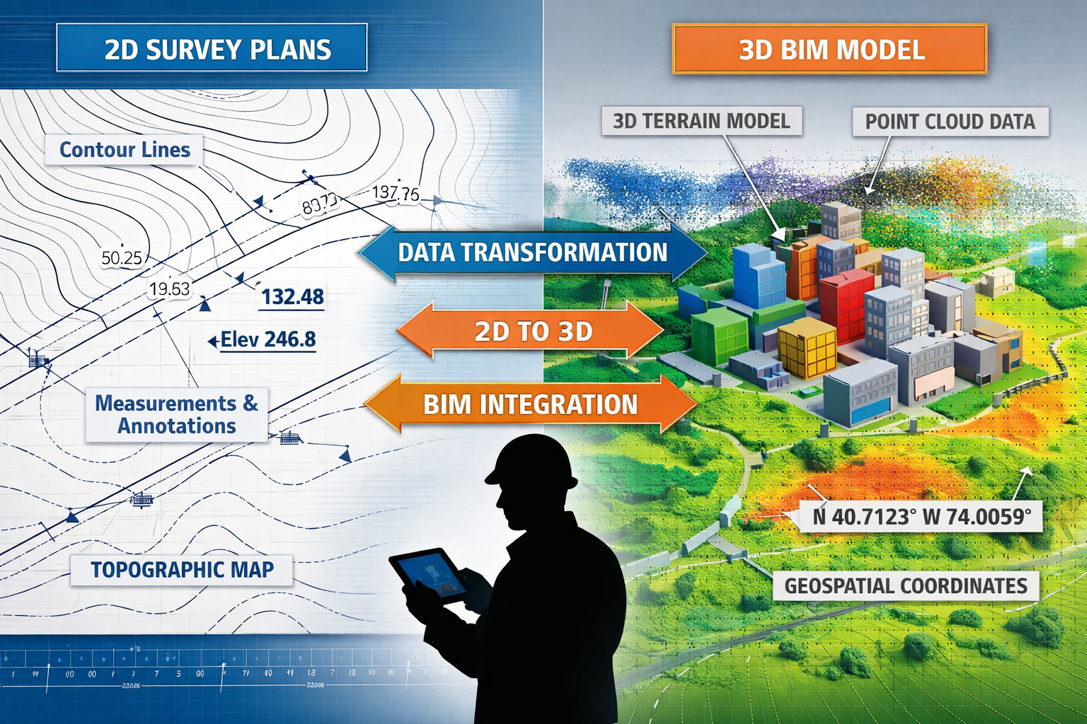
Building Information Modeling has transformed from a specialized architectural tool into a comprehensive project delivery methodology. For surveyors in 2026, BIM integration means capturing spatial data in formats that seamlessly feed into collaborative digital environments where architects design, engineers analyze, and contractors plan construction sequences.
What Is BIM Integration in Surveying?
BIM integration refers to the process of incorporating accurate geospatial survey data—including topographic information, existing conditions, boundary measurements, and as-built documentation—directly into three-dimensional Building Information Models. Rather than delivering static PDF plans or isolated CAD files, modern surveyors provide intelligent, data-rich digital representations that become foundational layers within comprehensive BIM environments.
This integration enables:
✅ Real-time data accessibility across project teams
✅ Automated clash detection between proposed designs and existing conditions
✅ Coordinated decision-making based on shared, accurate information
✅ Reduced rework from design conflicts discovered during construction
✅ Enhanced visualization for stakeholders and approval processes
The Evolution of Surveying in Digital Construction
Traditional surveying workflows operated in relative isolation. Surveyors collected measurements, processed data in specialized software, and delivered final documents to clients who manually incorporated that information into separate design processes. This sequential handoff created opportunities for errors, misinterpretations, and coordination failures.
The surveying profession entered 2026 amid accelerated digital transformation driven by pressure to deliver faster, more accurate results while navigating workforce shortages and evolving client expectations[3]. According to Trimble experts, the convergence of artificial intelligence, cloud-based collaboration platforms, and interoperable hardware and software is fundamentally reshaping how spatial data is captured, processed, and shared in surveying[3].
Modern commercial property surveyors now work within integrated workflows where survey data immediately populates shared digital environments, enabling architects to design with confidence in existing conditions and engineers to analyze structural requirements based on accurate terrain models.
The Technical Foundation of BIM Integration for Surveyors
Successful BIM Integration for Surveyors: Bridging Geospatial Data and Construction Planning requires understanding both the technical infrastructure and the collaborative processes that make integration possible.
Data Capture Technologies and Methodologies
Modern surveyors employ multiple data capture technologies, each optimized for different project requirements:
| Technology | Primary Use | BIM Integration Advantage |
|---|---|---|
| Total Stations | Precise point measurements | Direct coordinate export to BIM platforms |
| GPS/GNSS Systems | Large-area positioning | Georeferenced data for site context |
| Terrestrial Laser Scanning | Detailed existing conditions | High-density point clouds for as-built models |
| UAV/Drone Photogrammetry | Aerial site mapping | Rapid terrain modeling and progress monitoring |
| Mobile Mapping Systems | Linear infrastructure | Continuous data collection along corridors |
The key to effective BIM integration lies not just in data collection but in data processing workflows that transform raw measurements into intelligent, structured information. Point clouds from laser scanning must be registered, cleaned, and classified. Photogrammetric models require processing into accurate orthophotos and digital surface models. All outputs must align to consistent coordinate systems and accuracy standards.
Common Data Environments: The Integration Hub
Common Data Environments are accelerating across the construction industry and now function as both delivery platforms and collaboration tools, fundamentally changing how spatial information integrates with broader project data rather than existing as isolated static plans or point clouds[3].
A CDE serves as the single source of truth for all project information, providing:
🔹 Centralized file storage with version control
🔹 Access permissions tailored to project roles
🔹 Workflow automation for review and approval processes
🔹 Audit trails documenting all changes and decisions
🔹 Integration APIs connecting surveying software to BIM platforms
Cloud platforms deliver instant file sharing, 3D visualization in browsers, real-time revision syncing, and integrated communication with engineers and architects—moving beyond static document deliverables[1]. Approximately 48% of BIM deployments now use cloud platforms, enabling remote collaboration across geographies—particularly valuable for outsourced teams and real-time data access[5].
For surveyors, CDEs eliminate the traditional deliverable handoff. Survey data uploads directly to shared environments where downstream users immediately access current information. When site conditions change or additional measurements are needed, surveyors update the CDE, and all stakeholders receive notifications of new data availability.
Interoperability Standards and Data Exchange
True interoperability ensures that spatial information flows seamlessly between systems so every stakeholder can access the same data within their preferred tools, reducing friction in data handoffs and expanding the potential client base for surveying firms[3].
Critical interoperability standards include:
IFC (Industry Foundation Classes): The international standard for BIM data exchange, enabling survey-derived geometry and metadata to transfer between different software platforms without data loss.
ISO 19650: The international framework for managing information throughout the lifecycle of built assets, defining processes for collaborative working and information delivery.
LandXML: Specialized format for civil engineering and surveying data, particularly terrain models, alignments, and parcel information.
E57: Compact file format for storing point cloud data from 3D imaging systems with metadata preservation.
BIM projects require adherence to standards such as IFC and ISO 19650 with consistent data exchange protocols, with professional BIM service providers increasingly ensuring consistent, interoperable outputs through established workflows and quality assurance processes[5].
Surveyors implementing these standards position their deliverables for seamless integration regardless of which BIM authoring tools architects and engineers prefer—whether Revit, ArchiCAD, Tekla, or other platforms.
Collaborative Workflows: How Surveyors Bridge Geospatial Data and Construction Planning
The true value of BIM Integration for Surveyors: Bridging Geospatial Data and Construction Planning emerges through collaborative workflows that connect survey data to design decisions and construction execution.
Pre-Design Phase: Establishing the Digital Foundation
Before architects sketch initial concepts, surveyors establish the digital foundation upon which all subsequent work builds. This phase includes:
Site Survey and Existing Conditions Modeling: Comprehensive topographic surveys capture terrain features, existing structures, utilities, vegetation, and other site characteristics. Rather than delivering 2D contour plans, surveyors create three-dimensional terrain models and point cloud representations that architects import directly into BIM authoring software.
Boundary and Legal Surveys: Precise property boundaries, easements, and setback requirements become georeferenced layers within the BIM environment, enabling automated compliance checking as designs develop.
Utility Mapping and Subsurface Investigation: Underground infrastructure locations integrate as intelligent objects within the model, allowing engineers to design foundations and services that avoid conflicts with existing utilities.
Similar to how chartered surveyors in Essex conduct comprehensive property assessments, modern surveying firms deliver integrated digital site models that inform every subsequent project decision.
Design Development: Real-Time Coordination
Design conversations increasingly occur directly within 3D models rather than on traditional 2D plans, enabling quicker iterations and stronger alignment throughout design and construction phases[3].
During design development, surveyors maintain active collaboration with design teams:
Continuous Site Monitoring: As site conditions evolve—perhaps due to adjacent construction, seasonal changes, or preliminary site work—surveyors update the digital site model. These updates propagate through the BIM environment, alerting designers to changed conditions that might affect their work.
Design Validation Against Existing Conditions: Architects and engineers design within the context of accurate survey data. When questions arise about specific site features, surveyors can quickly capture additional detail or clarify measurements without scheduling formal site visits.
Clash Detection and Conflict Resolution: AI-driven clash detection expanding across BIM implementations now incorporates AI algorithms for accurate clash detection and real-time adjustments using predictive analytics to identify design conflicts in advance and minimize project delays[2][5]. Surveyors contribute by ensuring the existing conditions model maintains sufficient accuracy and detail for reliable clash detection.
Construction Phase: As-Built Documentation and Quality Control
The surveyor's role extends throughout construction, supporting quality control and creating as-built documentation:
Layout and Control Surveys: Construction teams rely on surveyors to translate BIM designs into physical layout on site. Modern workflows enable surveyors to extract layout coordinates directly from BIM models, ensuring constructed elements match design intent.
Progress Monitoring: Regular drone surveys or laser scans capture construction progress, comparing actual built conditions against the planned BIM model. Deviations trigger alerts, enabling rapid corrective action before errors compound.
As-Built Model Development: Rather than creating separate as-built drawings, surveyors update the BIM model to reflect actual constructed conditions. This living digital twin becomes the foundation for facility management and future renovation projects.
Professional stock condition surveys demonstrate how detailed documentation supports long-term asset management—a principle that extends naturally into BIM-based as-built modeling.
Post-Construction: Digital Twins and Facility Management
The integrated BIM model, enriched with survey-accurate as-built data, transitions into a digital twin for facility management. Building operators use this digital representation to:
- Plan maintenance activities with precise spatial context
- Manage renovations with accurate existing conditions data
- Optimize space utilization based on actual measurements
- Coordinate emergency response with detailed building information
Surveyors expanding role in project lifecycle means firms that deliver survey data optimized for 3D visualization and BIM integration position themselves as essential partners in collaborative workflows rather than simply vendors of measurement services, extending deliverables beyond traditional survey products[3].
Advanced Technologies Enhancing BIM Integration for Surveyors
Several emerging technologies are accelerating the effectiveness of BIM Integration for Surveyors: Bridging Geospatial Data and Construction Planning in 2026.
Artificial Intelligence and Machine Learning
AI applications in surveying and BIM integration include:
Automated Feature Extraction: Machine learning algorithms automatically identify and classify features within point cloud data—distinguishing walls from windows, pipes from ducts, terrain from vegetation—dramatically reducing manual processing time.
Predictive Analytics: AI analyzes historical project data to predict potential issues, such as areas where design conflicts commonly occur or site conditions that typically require additional investigation.
Quality Assurance: Automated comparison of survey data against design models identifies discrepancies that might indicate errors in either data capture or design development.
Intelligent Clash Detection: Beyond simple geometric interference, AI-enhanced clash detection considers construction sequencing, material properties, and tolerance requirements to prioritize conflicts requiring resolution[2][5].
Augmented and Mixed Reality
Building Information Modeling integration with Augmented Reality is elevating BIM's capabilities by allowing detailed 3D digital representations to be visualized in the real world[4].
AR applications for surveyors include:
📱 On-Site Visualization: Surveyors and construction teams view BIM models overlaid on physical sites through tablets or AR glasses, comparing design intent with existing conditions in real-time.
📱 Layout Verification: AR guidance helps construction crews position elements according to BIM specifications, reducing layout errors and rework.
📱 Client Communication: Non-technical stakeholders better understand proposed designs when viewing AR visualizations on actual sites, improving decision-making and approval processes.
📱 Training and Safety: AR overlays identify hazards, restricted areas, or underground utilities, enhancing site safety for all personnel.
4D and 5D BIM Integration
Fourth and fifth-dimensional BIM (combining scheduling, cost-estimation, and sustainability data) is being increasingly outsourced, offering clients detailed project simulations before construction begins[5].
4D BIM adds the time dimension, linking construction activities to the 3D model. Surveyors contribute by:
- Providing accurate existing conditions that inform realistic construction sequencing
- Monitoring actual progress against 4D schedules through periodic surveys
- Validating that site logistics plans account for actual terrain and access constraints
5D BIM incorporates cost data, enabling quantity takeoffs and budget tracking directly from the model. Survey-accurate models ensure quantity calculations reflect actual site conditions, reducing cost surprises during construction.
Internet of Things (IoT) and Real-Time Monitoring
Connected sensors embedded in construction sites and structures provide continuous data streams that integrate with BIM models:
🔧 Automated Monitoring Stations: Permanent survey control points with automated total stations track structural movement or settlement in real-time, updating the BIM model with current conditions.
🔧 Environmental Sensors: Weather stations, groundwater monitors, and air quality sensors provide context for construction decisions and as-built documentation.
🔧 Equipment Tracking: GPS-enabled construction equipment locations appear within the BIM environment, supporting logistics planning and safety management.
Practical Implementation: Steps for Surveyors Adopting BIM Integration

Transitioning to BIM Integration for Surveyors: Bridging Geospatial Data and Construction Planning requires strategic planning and systematic implementation.
Assessing Current Capabilities and Gaps
Begin with honest evaluation of existing capabilities:
Technology Audit: What data capture equipment does the firm own? Which software platforms are currently in use? What file formats are routinely delivered to clients?
Skills Assessment: Do team members understand BIM concepts and workflows? Who has experience with point cloud processing, 3D modeling, or collaborative platforms?
Client Demand Analysis: Which clients are requesting BIM-integrated deliverables? What specific formats or standards do they require? What opportunities exist with new clients seeking integrated services?
Competitive Positioning: How are competitors approaching BIM integration? What differentiating capabilities could the firm develop?
Building Technical Infrastructure
Successful BIM integration requires appropriate technology investments:
Hardware Considerations:
- High-performance workstations for point cloud processing and 3D modeling
- Data capture equipment capable of producing BIM-compatible outputs
- Reliable high-speed internet for cloud platform access
- Adequate data storage for large point cloud and model files
Software Platforms:
- Point cloud processing software (Cyclone, ReCap, CloudCompare)
- 3D modeling tools compatible with BIM workflows (Revit, Civil 3D, Tekla)
- CDE platforms for collaboration (BIM 360, Trimble Connect, Procore)
- Data exchange and format conversion utilities
Network and Security:
- Secure cloud storage with appropriate access controls
- Backup systems protecting valuable project data
- Cybersecurity measures meeting client requirements
Developing BIM-Specific Skills
Technology alone doesn't ensure successful integration—team members need appropriate skills:
Training Programs: Formal training in BIM concepts, software platforms, and industry standards (ISO 19650, IFC specifications).
Certifications: Professional credentials demonstrating BIM competency enhance credibility with clients and partners.
Cross-Disciplinary Learning: Understanding architectural and engineering perspectives improves collaboration and deliverable quality.
Continuous Education: The technology landscape evolves rapidly; ongoing learning maintains competitive advantage.
Establishing Collaborative Processes
Process development ensures consistent, high-quality deliverables:
Standard Operating Procedures: Document workflows for common project types, specifying data capture methods, processing steps, quality control checks, and delivery formats.
Quality Assurance Protocols: Implement systematic verification processes ensuring survey data meets accuracy requirements and integrates properly with BIM platforms.
Communication Templates: Develop clear communication protocols with architects, engineers, and contractors, establishing expectations for data sharing, update frequencies, and issue resolution.
Project Execution Plans: For significant projects, create detailed execution plans specifying roles, responsibilities, deliverables, schedules, and coordination procedures.
Much like the detailed planning required for RICS building surveys, BIM-integrated surveying demands systematic approaches ensuring nothing falls through the cracks.
Benefits and Business Case for BIM Integration
Understanding the tangible benefits helps justify investments in BIM Integration for Surveyors: Bridging Geospatial Data and Construction Planning.
Competitive Differentiation
Firms offering BIM-integrated services distinguish themselves in crowded markets. Clients increasingly view traditional survey deliverables as commodities, while integrated digital services command premium pricing and foster long-term partnerships.
Expanded Service Offerings
BIM integration opens new revenue streams:
- Continuous monitoring contracts providing ongoing as-built updates throughout construction
- Digital twin development for facility management applications
- Clash detection services identifying conflicts before construction
- 4D/5D consulting supporting project scheduling and cost management
- Training and consulting helping clients develop their own BIM capabilities
Improved Project Outcomes
Clients experience measurable benefits from BIM-integrated surveying:
💰 Reduced Rework: Early conflict detection prevents costly construction changes
💰 Faster Approvals: Better visualization accelerates stakeholder decision-making
💰 Lower Risk: Accurate existing conditions data reduces design assumptions and contingencies
💰 Enhanced Coordination: Shared digital environments improve communication across project teams
💰 Better Asset Management: Accurate as-built models support efficient facility operations
Operational Efficiency
Internal benefits include:
⚡ Streamlined Workflows: Automated data processing reduces manual drafting time
⚡ Reduced Callbacks: Comprehensive digital models minimize requests for additional information
⚡ Better Resource Utilization: Cloud collaboration enables flexible work arrangements
⚡ Knowledge Retention: Digital project archives preserve institutional knowledge
Challenges and Solutions in BIM Integration for Surveyors
Despite significant benefits, implementing BIM Integration for Surveyors: Bridging Geospatial Data and Construction Planning presents challenges requiring thoughtful solutions.
Challenge: Initial Investment Requirements
Problem: Hardware, software, training, and process development require substantial upfront investment, particularly challenging for smaller firms.
Solutions:
- Phased Implementation: Start with one project type or client segment, expanding gradually as capabilities develop and revenue increases
- Software Subscriptions: Cloud-based subscription models reduce initial costs compared to perpetual licenses
- Strategic Partnerships: Collaborate with complementary firms to share technology costs and expertise
- Client Cost-Sharing: Negotiate project budgets that fairly compensate for enhanced deliverables
Challenge: Skills Gap and Workforce Development
Problem: Experienced surveyors may lack BIM expertise, while new graduates need practical surveying skills alongside digital competencies.
Solutions:
- Mentorship Programs: Pair experienced surveyors with digitally-savvy younger staff for mutual learning
- Targeted Hiring: Recruit individuals with cross-disciplinary backgrounds bridging surveying and BIM
- Continuous Training: Allocate regular time and budget for professional development
- External Expertise: Engage consultants for specific projects while building internal capabilities
Challenge: Data Standardization and Quality Control
Problem: Inconsistent data formats, accuracy levels, or metadata create integration difficulties and quality issues.
Solutions:
- Standard Templates: Develop firm-wide templates for common deliverable types ensuring consistency
- Automated Validation: Implement software tools that automatically check data quality before delivery
- Clear Specifications: Establish detailed project specifications with clients defining accuracy requirements, file formats, and coordinate systems
- Regular Audits: Periodically review completed projects identifying improvement opportunities
Similar to quality standards maintained by chartered surveyors in Hertfordshire, systematic quality management ensures reliable outcomes.
Challenge: Interoperability Between Platforms
Problem: Different software platforms handle data differently, creating compatibility issues despite theoretical standards compliance.
Solutions:
- Testing Protocols: Test data exchange workflows with common software combinations before project deployment
- Multiple Export Formats: Provide deliverables in several formats accommodating different client platforms
- Direct Collaboration: Work directly with client BIM managers to resolve compatibility issues
- Vendor Engagement: Provide feedback to software vendors about interoperability problems
Challenge: Liability and Professional Responsibility
Problem: Integrated workflows blur traditional responsibility boundaries, creating potential liability concerns.
Solutions:
- Clear Contractual Language: Define scope, deliverables, accuracy standards, and limitations explicitly in contracts
- Professional Insurance: Ensure insurance coverage adequately addresses digital deliverable risks
- Disclaimer Documentation: Clearly communicate assumptions, limitations, and appropriate use of survey data
- Quality Certifications: Implement ISO 9001 or similar quality management systems demonstrating professional rigor
Future Trends in BIM Integration for Surveyors
Looking beyond 2026, several trends will further transform BIM Integration for Surveyors: Bridging Geospatial Data and Construction Planning.
Autonomous Data Capture
Robotic total stations, autonomous drones, and mobile mapping systems will increasingly operate with minimal human supervision, continuously capturing site data that automatically updates BIM models. Surveyors will transition from equipment operators to data managers and quality controllers.
AI-Powered Processing
Machine learning will handle increasingly sophisticated processing tasks—automatically generating accurate terrain models from raw point clouds, identifying changes between survey epochs, or extracting as-built information from construction progress scans. Human expertise will focus on validation, exception handling, and strategic decision-making.
Blockchain for Data Integrity
Blockchain technology may provide immutable audit trails for survey data, documenting exactly when measurements were captured, who processed them, and what changes occurred. This transparency could enhance trust in collaborative environments and provide clear liability protection.
Integration with Smart Cities and Digital Infrastructure
Survey data will increasingly feed into broader smart city initiatives and national digital infrastructure programs. Surveyors will contribute to comprehensive digital twins of entire urban areas, supporting infrastructure planning, disaster response, and urban management.
Sustainability and Carbon Tracking
5D BIM will evolve to include environmental impact data, with surveyors contributing to carbon footprint calculations through accurate quantity takeoffs and material assessments. Survey data will support circular economy initiatives by documenting existing materials available for reuse.
Enhanced Reality Environments
Beyond simple AR overlays, mixed reality environments will enable fully immersive collaboration where distributed teams simultaneously interact with shared BIM models as if physically present together. Surveyors will facilitate these experiences by providing the accurate spatial foundation.
Case Studies: BIM Integration Success Stories

Real-world examples illustrate the practical value of BIM Integration for Surveyors: Bridging Geospatial Data and Construction Planning.
Case Study 1: Urban Infrastructure Redevelopment
Project: Major city center redevelopment including underground utilities, transit connections, and mixed-use buildings.
Challenge: Complex existing conditions with incomplete as-built documentation, requiring coordination among multiple design firms and utility providers.
Surveying Approach:
- Comprehensive utility mapping using ground-penetrating radar and vacuum excavation verification
- Terrestrial laser scanning of existing structures and underground spaces
- Continuous drone monitoring throughout demolition and construction
- All data integrated into federated BIM model accessible through cloud CDE
Outcomes:
- 40% reduction in utility conflicts compared to similar projects
- Three-week acceleration in design approval process due to improved visualization
- Accurate as-built model supporting future facility management
- Enhanced safety through comprehensive underground hazard documentation
Case Study 2: Highway Corridor Expansion
Project: 15-mile highway widening with multiple bridge replacements and interchange modifications.
Challenge: Maintaining traffic flow during construction while coordinating numerous contractors and minimizing environmental impact.
Surveying Approach:
- Mobile mapping system captured entire corridor in high-resolution point clouds
- Aerial photogrammetry provided terrain models and environmental context
- Regular monitoring surveys tracked construction progress against 4D schedule
- BIM integration enabled automated quantity calculations and earthwork balancing
Outcomes:
- 25% reduction in earthwork costs through optimized cut-fill balancing
- Real-time progress tracking identified schedule delays enabling proactive mitigation
- Environmental compliance documentation streamlined through integrated spatial data
- Digital as-built model supports long-term maintenance planning
Case Study 3: Historic Building Renovation
Project: Adaptive reuse of century-old industrial building for modern office and retail space.
Challenge: No accurate architectural documentation existed; structural modifications required careful analysis of existing conditions.
Surveying Approach:
- High-resolution laser scanning captured detailed existing conditions
- Scan-to-BIM processing created accurate architectural model
- Structural engineers analyzed load-bearing capacity within BIM environment
- AR visualization helped preservation authorities evaluate proposed modifications
Outcomes:
- Accurate existing conditions model eliminated design assumptions
- Structural analysis identified cost-effective reinforcement strategies
- Heritage approval process accelerated through compelling AR presentations
- Construction proceeded with minimal unforeseen conditions
Professional firms like chartered surveyors in Islington apply similar integrated approaches to complex urban projects.
Selecting the Right Tools and Partners
Successful BIM Integration for Surveyors: Bridging Geospatial Data and Construction Planning requires appropriate technology and collaborative relationships.
Evaluating BIM Software Platforms
When selecting BIM-compatible software, consider:
Interoperability: Does the platform support industry-standard formats (IFC, LandXML, E57)? Can it exchange data with common architectural and engineering software?
Cloud Capabilities: Does it support cloud-based collaboration? Can multiple users access and edit data simultaneously?
Scalability: Will the platform handle projects of varying sizes and complexities? Can it accommodate firm growth?
Training and Support: What learning resources are available? How responsive is technical support?
Cost Structure: What is the total cost of ownership including licenses, training, and ongoing support?
Integration Ecosystem: What third-party tools and plugins extend functionality? Are APIs available for custom integrations?
Building Collaborative Partnerships
BIM integration succeeds through strong relationships:
Architects and Engineers: Establish mutual understanding of data requirements, exchange formats, and coordination procedures. Regular communication prevents misunderstandings.
General Contractors: Understand construction sequencing needs and site logistics constraints. Provide survey data that directly supports construction activities.
Technology Vendors: Maintain relationships with equipment and software providers for technical support, training, and early access to new capabilities.
BIM Consultants: For firms new to BIM integration, experienced consultants can accelerate implementation and prevent costly mistakes.
Professional Organizations: Participate in industry associations focused on BIM and digital construction to stay current with evolving practices.
When determining what survey you need, consider how different survey types integrate with BIM workflows and project requirements.
Regulatory and Professional Standards
BIM Integration for Surveyors: Bridging Geospatial Data and Construction Planning operates within evolving regulatory and professional frameworks.
ISO 19650 Information Management
The ISO 19650 series provides international standards for managing information throughout the lifecycle of built assets using Building Information Modeling. Key principles include:
- Common Data Environment: Centralized information management with controlled workflows
- Information Requirements: Clear definition of what information is needed, when, and in what format
- Level of Information Need: Appropriate detail levels for different project stages
- Collaborative Production: Structured processes for creating and sharing information
Surveyors adopting ISO 19650 principles demonstrate professional maturity and readiness for complex collaborative projects.
Professional Licensing and Certification
Various professional bodies offer BIM-related credentials:
- RICS (Royal Institution of Chartered Surveyors): Provides guidance on BIM implementation and digital surveying practices
- NSPS (National Society of Professional Surveyors): Offers resources on technology integration and professional development
- buildingSMART: Administers certifications in IFC implementation and openBIM workflows
- Autodesk/Trimble/Bentley: Vendor-specific certifications demonstrating software proficiency
These credentials enhance professional credibility and demonstrate commitment to digital excellence.
Data Privacy and Security
Integrated BIM workflows involve sharing detailed spatial information through cloud platforms, raising privacy and security considerations:
🔒 Access Controls: Implement appropriate permissions ensuring only authorized personnel access sensitive data
🔒 Data Encryption: Use encrypted connections and storage for confidential project information
🔒 Compliance Requirements: Understand client-specific security requirements, particularly for government or critical infrastructure projects
🔒 Backup and Recovery: Maintain robust backup systems protecting against data loss
🔒 Contractual Protections: Include clear data ownership and usage provisions in client agreements
Conclusion: Embracing the Future of Surveying
BIM Integration for Surveyors: Bridging Geospatial Data and Construction Planning represents far more than adopting new software—it fundamentally redefines the surveying profession's role in the built environment. Surveyors who successfully navigate this transformation position themselves as essential collaborators in integrated project delivery, contributing strategic value throughout the entire project lifecycle rather than simply providing measurement services.
The trends shaping 2026 and beyond—cloud-based collaboration platforms, AI-driven analytics, augmented reality visualization, and comprehensive digital twins—all depend on accurate, well-structured geospatial data that only professional surveyors can provide. The question isn't whether to embrace BIM integration, but how quickly and effectively firms can develop the capabilities clients increasingly demand.
Actionable Next Steps
For surveying firms ready to advance their BIM integration capabilities:
-
Assess Current Position: Conduct honest evaluation of existing technology, skills, and client demand for integrated services
-
Develop Strategic Plan: Create phased implementation roadmap balancing investment requirements with revenue opportunities
-
Invest in Foundation: Acquire essential hardware, software, and training establishing basic BIM integration capabilities
-
Start Small: Select pilot project with supportive client to test workflows and build confidence
-
Document and Refine: Capture lessons learned, develop standard operating procedures, and continuously improve processes
-
Expand Capabilities: Gradually add advanced services like 4D/5D integration, AR visualization, or AI-powered analytics
-
Market Differentiation: Communicate new capabilities to existing and prospective clients through case studies and demonstrations
-
Stay Current: Maintain ongoing engagement with industry trends, standards development, and emerging technologies
-
Build Partnerships: Develop collaborative relationships with architects, engineers, contractors, and technology providers
-
Measure Success: Track metrics like project efficiency, client satisfaction, and revenue from integrated services
The future belongs to surveyors who recognize that their fundamental value lies not in measurement equipment or calculation skills, but in the ability to capture, structure, and deliver spatial intelligence that empowers better decision-making throughout the built environment lifecycle. By bridging geospatial data and construction planning through effective BIM integration, surveyors secure their essential role in the digital construction revolution transforming the industry in 2026 and beyond.
Whether working on commercial building surveys, infrastructure projects, or complex urban developments, the principles of BIM integration enhance accuracy, efficiency, and collaboration—delivering measurable value to clients while advancing the surveying profession into its digital future.
References
[1] Future Land Surveying 2026 – https://haller-blanchard.com/future-land-surveying-2026/
[2] Paperinformation – https://www.scirp.org/journal/paperinformation?paperid=148738
[3] Doubling Down On Digital – https://amerisurv.com/2026/02/01/doubling-down-on-digital/
[4] Top 3 Game Changing Integrations In Construction Technology For 2026 – https://www.civilvisor.com.au/post/top-3-game-changing-integrations-in-construction-technology-for-2026
[5] Why Outsourcing Bim Services Is Growing Fast In 2026 – https://acurabim.com/why-outsourcing-bim-services-is-growing-fast-in-2026/