
The surveying industry stands at a pivotal moment in 2026. Traditional ground-based methods that once took weeks to complete are being revolutionized by Autonomous Drones and Multi-Sensor Technology: The Game-Changer for Large-Scale Property Surveys. Imagine capturing every detail of a 500-acre development site—from topographic elevation to thermal anomalies—in a single afternoon flight, with accuracy down to one centimeter. This isn't science fiction; it's the reality transforming how professionals approach agricultural estates, commercial developments, and large-scale property assessments today.
The convergence of autonomous flight systems, predictive modeling, automatic altitude adjustment, and integrated multi-sensor capabilities has created an unprecedented opportunity for property professionals. Where traditional surveying methods required extensive ground crews, weeks of fieldwork, and significant safety risks, autonomous drone systems now deliver comprehensive data in hours with minimal human intervention[2].
Key Takeaways
- 🚁 Autonomous drone swarms can complete large-scale property surveys in hours instead of weeks, reducing project timelines by up to 90% while maintaining centimeter-level accuracy[1][2]
- 📊 Multi-sensor integration combines LiDAR, thermal imaging, RGB photography, and GPS data into unified platforms, enabling single-flight comprehensive property analysis[1][6]
- 💰 Significant cost savings result from reduced personnel requirements, faster deployment, and elimination of safety risks associated with traditional ground-based surveying methods[2]
- 🎯 Predictive modeling and automatic altitude adjustment enable autonomous systems to navigate complex terrain without prior maps, accessing previously difficult-to-survey properties[4]
- 📈 Real-time data processing through cloud-based platforms allows surveyors to monitor progress, identify issues, and make informed decisions during active survey operations[1]
Understanding Autonomous Drones and Multi-Sensor Technology in Property Surveying
What Makes Modern Drone Surveying "Autonomous"
The term "autonomous" represents a fundamental shift from manually piloted drones to intelligent systems capable of independent decision-making. In 2026, autonomous drone platforms incorporate several critical technologies that enable true hands-off operation:
Predictive Flight Modeling 🧠
Modern autonomous systems analyze property characteristics before takeoff, calculating optimal flight paths that account for terrain variations, obstacles, and data collection requirements. This pre-flight intelligence ensures comprehensive coverage while minimizing battery consumption and flight time.
Automatic Altitude Adjustment 📏
Unlike fixed-altitude drones, autonomous surveying platforms continuously adjust their height based on terrain elevation. This maintains consistent ground sampling distance (GSD) across varying topography, ensuring uniform data quality whether surveying flat agricultural land or hilly development sites.
AI-Powered Navigation 🤖
Advanced autonomous systems utilize artificial intelligence to navigate complex environments without relying on GPS signals, pre-existing maps, or wireless infrastructure[4]. This capability proves essential when surveying remote properties, dense urban areas with GPS interference, or indoor commercial spaces.
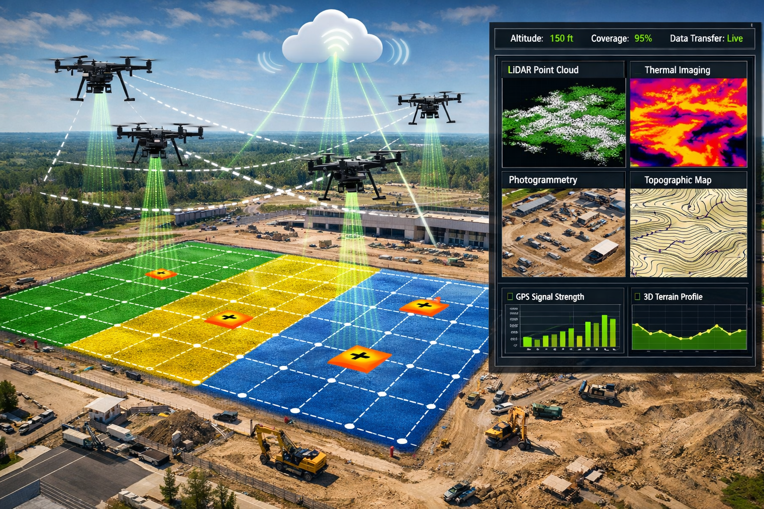
Swarm Coordination 👥
Perhaps most revolutionary, autonomous drone swarms now work together on coordinated flight paths, dramatically accelerating data collection for large-scale properties[1]. Multiple drones communicate in real-time, dividing survey areas and avoiding collisions while maintaining data consistency.
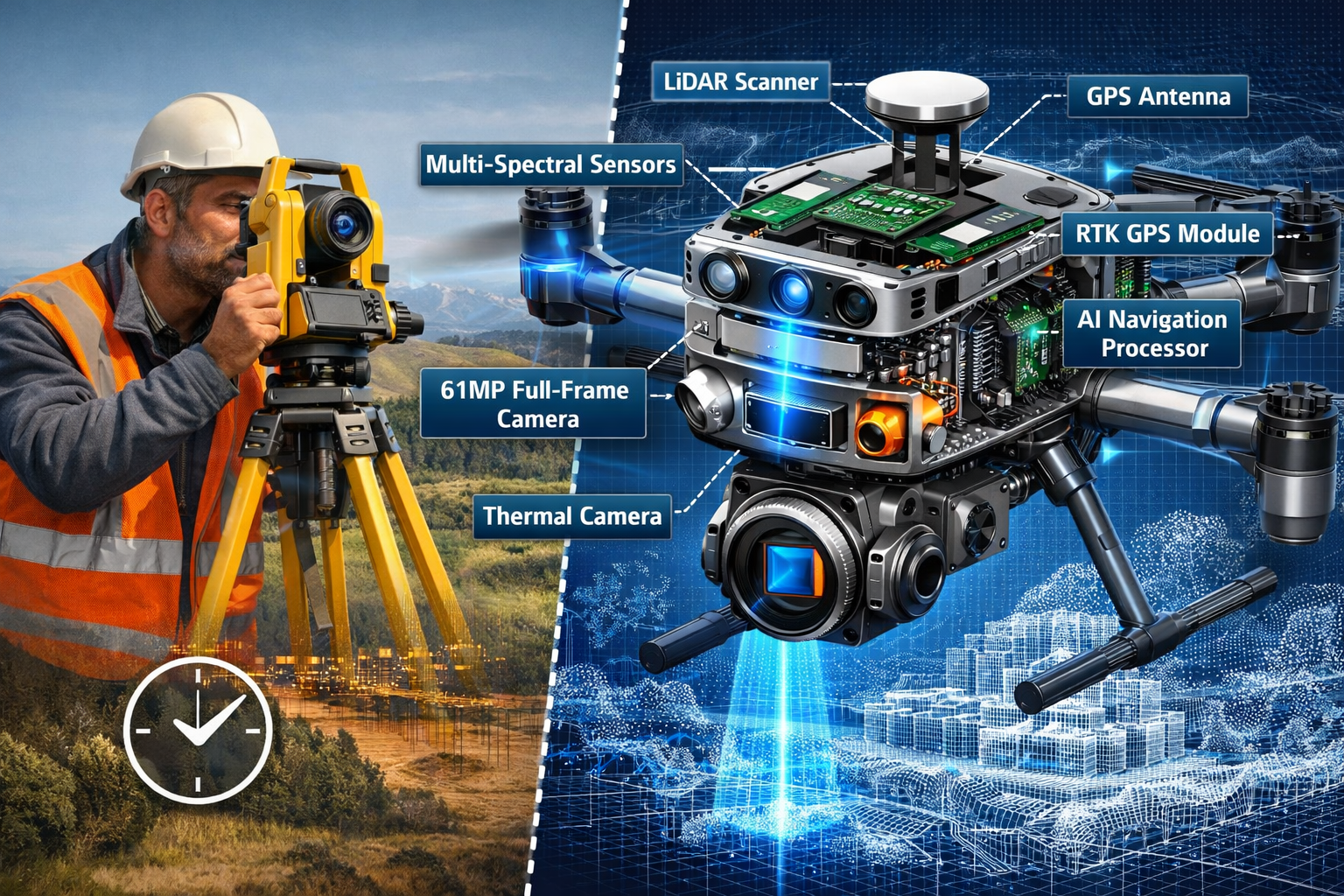
The Multi-Sensor Advantage
The true power of Autonomous Drones and Multi-Sensor Technology: The Game-Changer for Large-Scale Property Surveys lies in simultaneous data capture across multiple spectrums and measurement types. Modern surveying drones integrate:
| Sensor Type | Primary Function | Key Applications |
|---|---|---|
| LiDAR | 3D point cloud generation | Topographic mapping, volumetric calculations, vegetation penetration |
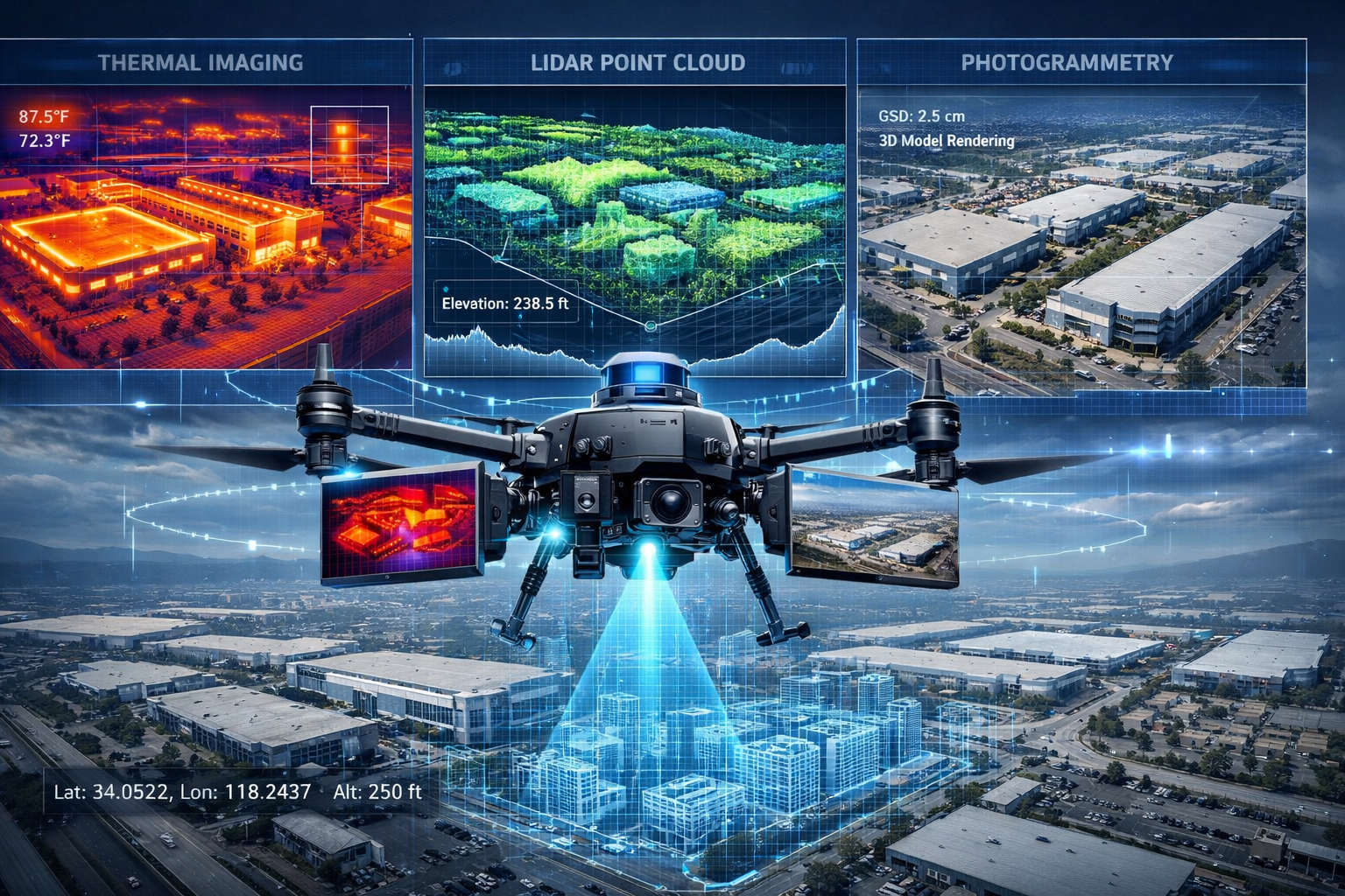
| RGB Camera (61MP+) | High-resolution imagery | Visual documentation, photogrammetry, orthomosaic creation[6] |
| Thermal Imaging | Temperature differential mapping | Building envelope analysis, irrigation assessment, heat loss detection |
| Multispectral Sensors | Vegetation health analysis | Agricultural monitoring, crop stress identification, yield prediction |
| RTK GPS | Centimeter-level positioning | Ground control, absolute accuracy verification, georeferencing[6] |
This multi-sensor approach enables single-flight comprehensive analysis—a game-changing capability for large-scale property assessments. Rather than conducting separate surveys for topography, thermal analysis, and visual documentation, autonomous systems capture all data simultaneously, reducing costs and ensuring temporal consistency across datasets.
For professionals conducting commercial building surveys, this integrated approach means identifying structural issues, drainage problems, and thermal inefficiencies in one efficient operation.
How Autonomous Drones and Multi-Sensor Technology Transform Large-Scale Property Surveys
Agricultural Property Assessments
Agricultural estates present unique surveying challenges: vast acreage, variable terrain, seasonal accessibility constraints, and the need for both topographic and vegetation health data. Autonomous Drones and Multi-Sensor Technology: The Game-Changer for Large-Scale Property Surveys addresses each challenge comprehensively.
Rapid Acreage Coverage 🌾
Traditional ground-based surveys of 500+ acre agricultural properties could take weeks and require significant personnel. Autonomous drone systems complete the same surveys in hours[2]. For example, a 1,000-acre farm that previously required 10-15 days of fieldwork can now be comprehensively surveyed in a single day with a coordinated autonomous drone swarm.
Integrated Crop Health Analysis
Multi-sensor platforms simultaneously capture:
- Topographic data via LiDAR for drainage planning and irrigation optimization
- Multispectral imagery revealing crop stress, disease patterns, and growth variations
- Thermal mapping identifying irrigation system failures and soil moisture variations
- High-resolution RGB photography documenting current conditions and infrastructure
This integrated dataset enables agricultural property valuations that account for both land characteristics and productive capacity—critical information for investors, estate planning, and property certification requirements.
Volumetric Calculations for Storage and Stockpiles
LiDAR-equipped autonomous drones excel at calculating volumes for grain storage, silage piles, and material stockpiles. Accuracy within 1-2% enables precise inventory management and financial reporting[6].
Commercial Development Site Surveys
Large-scale commercial developments demand comprehensive baseline data, ongoing progress monitoring, and final as-built verification. Autonomous drone technology revolutionizes each phase.
Pre-Development Baseline Surveys 🏗️
Before breaking ground, developers need detailed topographic information, drainage analysis, and environmental baseline documentation. Autonomous multi-sensor drones deliver:
- Centimeter-accurate elevation models for grading and drainage design[6]
- Comprehensive visual documentation establishing pre-construction conditions
- Thermal surveys identifying existing underground utilities and heat signatures
- Vegetation mapping for environmental impact assessments
The speed advantage proves particularly valuable when site control windows are limited or when competing for development opportunities requiring rapid due diligence.
Construction Progress Monitoring 📊
One of the most valuable applications involves periodic autonomous surveys during construction. Deploying drone surveys at relatively low cost throughout project timelines enables:
- Progress verification against project schedules and milestones
- Earthwork volume calculations for payment verification and material tracking
- Quality control identifying deviations from design specifications before they become costly problems[2]
- Stakeholder communication through visual documentation and 3D models
A 2022 collaboration between Trimble and Exyn Technologies demonstrated autonomous construction surveying capabilities by combining robotic systems, autonomous AI navigation, and 3D laser scanning[4]—technology now deployed across commercial projects in 2026.
As-Built Documentation
Final surveys capture completed development conditions with unprecedented detail. The combination of LiDAR point clouds, high-resolution imagery, and thermal analysis creates comprehensive as-built records valuable for facility management, future renovations, and dilapidation surveys.
Residential Development and Estate Surveys
Large residential estates and development parcels benefit significantly from autonomous drone surveying, particularly when traditional access proves challenging.
Boundary and Topographic Surveys
Autonomous drones equipped with RTK GPS achieve absolute accuracy down to 1cm[6], making them suitable for boundary verification and topographic mapping that previously required extensive ground-based total station work. When combined with ground control points, drone-derived data meets professional surveying standards for many applications.
Roof and Structural Assessments 🏘️
Multi-story residential developments and historic estates present access challenges and safety concerns for traditional inspection methods. Autonomous drones with thermal imaging capabilities identify:
- Roof membrane failures and water intrusion
- Insulation deficiencies and thermal bridging
- Structural anomalies requiring further investigation
- Chimney and masonry condition issues
For property buyers considering whether they need a survey when purchasing, drone-enhanced surveys provide comprehensive information without the limitations of ground-based visual inspection alone.
Estate Planning and Valuation
Large residential estates require detailed documentation for inheritance planning, taxation, and probate valuation. Autonomous drone surveys provide:
- Comprehensive visual records of all structures and improvements
- Accurate measurements of buildings, gardens, and landscape features
- Thermal analysis identifying maintenance requirements
- 3D models enabling virtual property tours for remote beneficiaries
The Technical Advantages: Why Autonomous Drones and Multi-Sensor Technology Are Game-Changers
Speed and Efficiency Gains
The time savings delivered by Autonomous Drones and Multi-Sensor Technology: The Game-Changer for Large-Scale Property Surveys fundamentally change project economics and feasibility.
Deployment Speed ⚡
Traditional large-scale surveys require:
- Mobilizing ground crews and equipment
- Establishing control networks
- Systematic ground-based data collection
- Equipment repositioning and setup
This process typically spans weeks or months. In contrast, autonomous drone systems deploy in days rather than weeks or months[3], with many projects completed in hours once on-site.
Data Collection Acceleration
Consider a 200-acre commercial development site:
| Survey Method | Typical Duration | Personnel Required | Equipment Needs |
|---|---|---|---|
| Traditional Ground Survey | 15-20 days | 3-4 surveyors | Total station, GPS rover, levels |
| Manual Drone Survey | 3-5 days | 2 surveyors + pilot | Drone, ground control, processing workstation |
| Autonomous Drone Swarm | 4-8 hours | 1 operator | Autonomous system, minimal ground control[1] |
This acceleration enables survey deployment during brief weather windows, rapid response to client needs, and cost-effective periodic monitoring throughout project lifecycles.
Cost Efficiency and Resource Optimization
While autonomous drone systems require higher initial technology investment, operational cost advantages prove substantial.
Reduced Personnel Requirements 💰
Traditional surveys demand multiple trained professionals working extended periods. Autonomous systems require minimal supervision, dramatically reducing labor costs—particularly significant given the surveying industry's labor supply challenges[3].
Equipment Efficiency
Multi-sensor integration means one flight captures data that previously required separate surveys:
- Topographic survey (traditional methods)
- Thermal imaging survey (separate deployment)
- Visual documentation (additional effort)
- Vegetation analysis (specialized equipment)
Consolidating these into single autonomous flights eliminates redundant mobilization, setup, and fieldwork costs.
Reduced Rework and Change Orders
Comprehensive baseline data and ongoing monitoring identify issues early, when corrections cost less. For construction projects, this translates to fewer change orders, reduced schedule delays, and improved budget performance[2].
Safety and Risk Mitigation
Perhaps the most compelling advantage involves eliminating surveyor exposure to hazardous conditions.
Eliminated Elevation Risks ⚠️
Traditional surveys of roofs, tall structures, and steep terrain require surveyors to work at height—a leading cause of industry injuries. Autonomous drones capture the same data remotely, eliminating fall risks entirely[2].
Traffic and Active Site Hazards
Surveying alongside busy roads or within active construction sites exposes personnel to vehicle strikes and equipment accidents. Remote aerial data collection removes surveyors from harm's way while often improving data quality through unrestricted vantage points.
Hazardous Environment Access
Contaminated sites, unstable structures, and environmentally sensitive areas pose risks to ground-based surveyors. Autonomous drones access these locations without personnel exposure or environmental impact.
For professionals conducting subsidence surveys or assessing structurally compromised buildings, this risk reduction proves invaluable.
Accuracy and Data Quality
Modern autonomous systems achieve accuracy levels matching or exceeding traditional methods for many applications.
Centimeter-Level Precision 📐
Advanced mapping drones equipped with 61MP full-frame RGB cameras and RTK GPS achieve absolute accuracy down to 1cm[6]—suitable for most property surveying applications and exceeding the precision of many traditional methods.
Point Density and Detail
LiDAR technology has reached maturity with dramatically improved point density and resolution compared to traditional methods[3]. Modern systems capture millions of points per second, creating detailed 3D models revealing subtle terrain features, structural details, and vegetation characteristics impossible to document through ground-based methods.
Temporal Consistency
Completing surveys in hours rather than weeks ensures all data represents the same moment in time—eliminating inconsistencies from weather changes, construction progress, or seasonal variations that affect multi-day traditional surveys.
Comprehensive Coverage
Autonomous systems ensure complete coverage without gaps. Predictive flight planning and automatic altitude adjustment guarantee consistent overlap and data quality across entire survey areas—reducing the human error factor inherent in manual surveys.
Overcoming Implementation Challenges
Regulatory Compliance and Airspace Management
Operating autonomous drones for commercial surveying requires navigating regulatory frameworks that continue evolving in 2026.
Aviation Authority Requirements ✈️
Commercial drone operations require appropriate certifications and operational approvals. In the UK, this includes:
- Operator registration and insurance
- Pilot qualifications (even for autonomous systems)
- Operational authorizations for specific flight scenarios
- Compliance with airspace restrictions
Successful implementation requires staying current with regulatory changes and maintaining proper documentation.
Privacy and Data Protection
High-resolution imagery and thermal data captured during property surveys may inadvertently include neighboring properties and individuals. Responsible operators implement:
- Privacy impact assessments
- Data minimization strategies
- Secure storage and transmission protocols
- Clear client communication about data handling
Technical Integration and Workflow Adaptation
Maximizing the benefits of Autonomous Drones and Multi-Sensor Technology: The Game-Changer for Large-Scale Property Surveys requires adapting traditional workflows.
Data Processing and Management 💻
Multi-sensor autonomous surveys generate massive datasets—often hundreds of gigabytes per project. Effective implementation requires:
- Cloud-based processing platforms that consolidate drone imagery, GPS data, LiDAR datasets, and robotic total station measurements into unified CAD, GIS, and mapping software[1]
- Automated processing workflows reducing manual intervention
- Scalable storage solutions maintaining project data accessibility
- Quality control procedures ensuring data accuracy and completeness
Software Integration
Survey deliverables must integrate with clients' existing systems. Modern platforms export to:
- CAD formats for engineering and architectural design
- GIS systems for spatial analysis and planning
- BIM (Building Information Modeling) for construction coordination
- Specialized software for agricultural management, facility operations, or property valuation
Staff Training and Skill Development
Transitioning from traditional surveying to autonomous drone operations requires new competencies:
- Drone operation and maintenance
- Multi-sensor calibration and validation
- Point cloud processing and analysis
- Photogrammetry and 3D modeling
Organizations must invest in training or recruit personnel with these specialized skills. Understanding what surveyors do in this evolving landscape helps define necessary capabilities.
Weather and Environmental Limitations
Despite technological advances, autonomous drone surveys face environmental constraints.
Weather Windows ☁️
Effective surveying requires:
- Wind speeds below operational limits (typically 15-25 mph depending on platform)
- Adequate visibility for visual sensors
- Dry conditions for optimal sensor performance
- Appropriate lighting for RGB photography
Autonomous systems can monitor conditions and automatically abort flights when parameters exceed safe limits, but weather still constrains deployment timing.
Seasonal Considerations
Vegetation surveys require specific seasonal timing for accurate analysis. Topographic surveys of heavily vegetated areas may need leaf-off conditions for ground surface penetration, even with LiDAR.
Battery and Range Limitations
Despite improvements, battery technology still limits flight duration to 20-45 minutes for most systems. Large-scale surveys require:
- Multiple battery sets and charging infrastructure
- Strategic flight planning to maximize coverage per battery
- Swarm coordination to parallelize coverage[1]
Real-World Applications and Case Studies
Agricultural Estate Transformation
A 750-acre mixed agricultural estate in rural England required comprehensive surveying for estate planning and potential development opportunities. Traditional methods would have required 3-4 weeks of fieldwork at significant cost.
Autonomous Drone Solution:
- Duration: 2 days (including setup and ground control establishment)
- Technology: Autonomous drone swarm with LiDAR, multispectral, and RGB sensors
- Deliverables:
- 1cm-resolution topographic model
- Vegetation health indices for all cultivated areas
- Drainage analysis and water flow modeling
- Complete visual documentation
- Volumetric calculations for storage facilities
Results:
- 85% time reduction compared to traditional methods
- 60% cost savings
- Comprehensive dataset enabling multiple use cases from single survey
- Identification of drainage issues previously unknown to estate management
Commercial Development Progress Monitoring
A £45 million mixed-use development covering 15 acres implemented monthly autonomous drone surveys throughout the 18-month construction period.
Implementation:
- Monthly autonomous surveys capturing progress
- Integration with project management software
- Automated earthwork volume calculations
- Thermal imaging identifying concrete curing issues
Benefits:
- Early identification of grading errors, saving £120,000 in potential rework
- Improved stakeholder communication through 3D visualizations
- Accurate progress verification for payment applications
- Comprehensive as-built documentation for facility management
This approach aligns with best practices outlined in guides to construction surveys.
Residential Estate Condition Assessment
A historic residential estate comprising multiple buildings across 50 acres required condition assessment for insurance and maintenance planning purposes.
Challenges:
- Multiple roof levels and architectural complexity
- Mature trees limiting ground-based visibility
- Safety concerns with traditional inspection methods
- Need for comprehensive thermal analysis
Autonomous Drone Approach:
- Complete aerial survey with thermal imaging
- Automated flight paths ensuring comprehensive coverage
- Integration with traditional RICS building surveys for ground-level detail
- 3D modeling enabling virtual inspections
Outcomes:
- Identification of roof failures invisible from ground level
- Thermal analysis revealing insulation deficiencies
- Comprehensive documentation for insurance purposes
- Maintenance prioritization based on condition data
- Zero safety incidents compared to ladder-based inspections
The Future of Property Surveying: Trends and Predictions
Artificial Intelligence and Machine Learning Integration
The next evolution of Autonomous Drones and Multi-Sensor Technology: The Game-Changer for Large-Scale Property Surveys involves deeper AI integration throughout the survey workflow.
Automated Feature Recognition 🤖
Machine learning algorithms increasingly identify and classify features automatically:
- Building footprints and roof types
- Vegetation species and health status
- Infrastructure elements (roads, utilities, drainage)
- Defects and anomalies requiring attention
This automation dramatically reduces post-processing time and improves consistency.
Predictive Analytics
AI-powered analysis of historical survey data enables predictive modeling:
- Subsidence risk prediction based on soil conditions and drainage
- Maintenance requirement forecasting from thermal and visual data
- Development suitability assessment from topographic and environmental factors
Enhanced Sensor Technologies
Sensor capabilities continue advancing, expanding autonomous drone survey applications.
Hyperspectral Imaging
Beyond multispectral sensors, hyperspectral systems capture hundreds of narrow spectral bands, enabling:
- Detailed material identification and classification
- Advanced vegetation stress analysis
- Contamination detection
- Moisture content mapping
Ground-Penetrating Radar (GPR)
Drone-mounted GPR systems map subsurface features:
- Underground utilities and infrastructure
- Archaeological features
- Soil composition and stratification
- Foundation depths and conditions
Advanced LiDAR
Next-generation LiDAR systems offer:
- Higher point densities for greater detail
- Improved vegetation penetration for ground surface modeling
- Bathymetric capabilities for underwater surveying
- Single-photon sensitivity for extended range
Integration with Robotic Ground Systems
The Trimble-Exyn collaboration demonstrated in 2022[4] foreshadows broader integration between aerial and ground-based autonomous systems.
Coordinated Air-Ground Surveys 🤝
Future implementations will coordinate:
- Aerial drones for rapid area coverage and overhead perspectives
- Ground-based robots for detailed building interiors and confined spaces
- Automated data fusion creating seamless indoor-outdoor models
This integration proves particularly valuable for comprehensive commercial property surveys requiring both external site analysis and internal building assessment.
Real-Time Analysis and Decision Support
Cloud computing advances enable real-time processing and analysis during active surveys.
Live Data Streaming
Surveyors monitor incoming data in real-time, enabling:
- Immediate quality verification
- On-the-fly coverage adjustments
- Instant identification of areas requiring additional detail
- Reduced need for return visits
Augmented Reality Integration
AR platforms overlay survey data onto real-world views:
- Visualizing proposed designs on existing sites
- Comparing as-built conditions to design specifications
- Identifying underground utilities before excavation
- Training and collaboration tools for distributed teams
Selecting the Right Autonomous Drone Survey Solution
Assessing Project Requirements
Not every property survey requires the full capabilities of advanced autonomous multi-sensor systems. Effective implementation starts with matching technology to needs.
Project Scale Considerations 📏
- Small properties (<5 acres): Traditional methods or basic drone surveys may prove more cost-effective
- Medium properties (5-50 acres): Single autonomous drone with multi-sensor payload typically optimal
- Large properties (>50 acres): Autonomous swarms and advanced coordination justify investment[1]
Data Requirements
Match sensor capabilities to deliverable needs:
- Topographic mapping only: LiDAR or photogrammetry sufficient
- Comprehensive analysis: Multi-sensor integration essential
- Specialized applications: Thermal, multispectral, or hyperspectral sensors required
Accuracy Standards
Different applications demand different precision:
- Planning and feasibility: 5-10cm accuracy adequate
- Design and engineering: 2-5cm accuracy typical
- Construction verification: 1-2cm accuracy required[6]
Evaluating Service Providers
When engaging autonomous drone survey services, assess:
Technical Capabilities ✅
- Sensor suite comprehensiveness and quality
- Processing software and workflow sophistication
- Deliverable format flexibility
- Quality control procedures
Experience and Expertise
- Track record with similar property types and scales
- Professional qualifications and certifications
- Integration with traditional surveying when required
- Understanding of client industry and needs
Regulatory Compliance
- Appropriate operational authorizations
- Insurance coverage adequacy
- Privacy and data protection protocols
- Safety management systems
For those considering whether traditional approaches like a Level 3 building survey remain appropriate, understanding how drone technology complements rather than replaces comprehensive property assessment proves valuable.
Building In-House Capabilities
Organizations conducting frequent large-scale property surveys may justify developing internal autonomous drone capabilities.
Investment Considerations 💼
- Equipment costs: £15,000-£150,000+ depending on platform and sensors
- Software licensing: £3,000-£15,000 annually for processing platforms
- Training expenses: £5,000-£20,000 per operator
- Ongoing maintenance: 10-15% of equipment cost annually
Break-Even Analysis
Calculate the survey volume required to justify in-house capabilities versus outsourcing. Factors include:
- Frequency of survey requirements
- Typical project scale and complexity
- Current outsourcing costs
- Available internal expertise
Hybrid Approaches
Many organizations adopt hybrid models:
- In-house capabilities for routine surveys
- Specialist contractors for complex or large-scale projects
- Partnership arrangements for specialized sensor requirements
Integrating Autonomous Drone Surveys with Traditional Methods
Complementary Approaches
Autonomous Drones and Multi-Sensor Technology: The Game-Changer for Large-Scale Property Surveys delivers maximum value when integrated with traditional surveying methods rather than viewed as complete replacement.
Ground Control and Validation 🎯
Even highly accurate autonomous systems benefit from:
- Strategic ground control points for georeferencing
- Validation measurements verifying aerial data accuracy
- Detailed measurements in critical areas requiring highest precision
- Traditional boundary surveys for legal documentation
Building Interior Assessment
Aerial surveys excel at external analysis but cannot replace internal inspection for:
- Structural condition assessment
- Building services evaluation
- Interior finish and fitting documentation
- Detailed defect identification
Comprehensive property assessments combine autonomous drone exterior surveys with traditional chartered surveyor interior inspections.
Specialized Testing
Certain assessments require physical sampling or specialized equipment:
- Materials testing and laboratory analysis
- Invasive structural investigation
- Utility tracing and verification
- Environmental contamination assessment
Workflow Integration Best Practices
Effective integration requires coordinated planning and execution.
Phased Approach 📋
- Initial autonomous survey: Rapid comprehensive data collection
- Data analysis and review: Identify areas requiring detailed investigation
- Targeted traditional surveys: Focus ground-based efforts on critical areas
- Data integration: Combine aerial and ground-based information
- Comprehensive reporting: Unified deliverables incorporating all data sources
Communication and Coordination
Successful integration demands:
- Clear scope definition for aerial versus ground-based components
- Coordinated scheduling minimizing overall project duration
- Shared data platforms enabling seamless information exchange
- Unified quality standards across all survey components
Documentation Standards
Maintain consistent documentation across survey methods:
- Common coordinate systems and datums
- Standardized accuracy specifications
- Integrated reporting formats
- Comprehensive metadata for all datasets
Conclusion: Embracing the Future of Large-Scale Property Surveys
Autonomous Drones and Multi-Sensor Technology: The Game-Changer for Large-Scale Property Surveys represents far more than incremental improvement—it fundamentally transforms what's possible in property assessment, development planning, and asset management. The convergence of autonomous flight systems, predictive modeling, automatic altitude adjustment, and integrated multi-sensor capabilities enables single-flight comprehensive analysis that was simply impossible with traditional methods.
The benefits prove compelling across all applications:
- Agricultural properties gain integrated topographic and crop health analysis in hours rather than weeks
- Commercial developments benefit from rapid baseline surveys, cost-effective progress monitoring, and comprehensive as-built documentation
- Residential estates receive detailed condition assessments without safety risks or access limitations
- All property types achieve significant cost savings, accelerated timelines, and enhanced data quality
Yet technology alone doesn't guarantee success. Effective implementation requires:
✅ Strategic assessment of when autonomous drone surveys deliver value versus traditional methods
✅ Integration planning combining aerial and ground-based approaches for comprehensive results
✅ Regulatory compliance ensuring operations meet aviation, privacy, and professional standards
✅ Workflow adaptation leveraging cloud platforms and automated processing for efficiency
✅ Continuous learning staying current with rapidly evolving capabilities and best practices
Actionable Next Steps
For property professionals, developers, and organizations conducting large-scale surveys:
1. Evaluate Current Survey Needs 📊
Review recent and planned survey projects to identify opportunities where autonomous drone technology delivers clear advantages in speed, cost, safety, or data quality.
2. Engage Qualified Providers
Consult with experienced autonomous drone survey specialists to understand capabilities, costs, and integration with existing processes. Request case studies demonstrating success with similar property types and scales.
3. Pilot Project Implementation
Start with a pilot project testing autonomous drone surveys on a non-critical property or development. Evaluate results, workflow integration, and value delivered before broader implementation.
4. Build Internal Knowledge
Invest in education for key personnel, understanding autonomous drone capabilities, limitations, and appropriate applications. This knowledge enables informed decisions about when to deploy advanced technology versus traditional methods.
5. Plan for Integration
Develop workflows integrating autonomous drone surveys with traditional methods, ensuring comprehensive property assessment that leverages the strengths of each approach. Consider how drone data enhances RICS home surveys and other established assessment protocols.
6. Monitor Technology Evolution
The autonomous drone surveying field continues rapid advancement. Maintain awareness of emerging capabilities—enhanced sensors, improved AI, extended range, and new applications—that may benefit future projects.
The surveying industry's labor challenges make autonomous technology not merely advantageous but essential for meeting future demand[3]. Organizations embracing these capabilities position themselves for competitive advantage, improved client service, and enhanced project outcomes.
The game has changed. The question isn't whether autonomous drones and multi-sensor technology will transform large-scale property surveys—they already have. The question is whether your organization will lead this transformation or struggle to catch up.
References
[1] How Technology Is Revolutionizing Land Surveys – https://www.firstchoicesurveying.com/blog/how-technology-is-revolutionizing-land-surveys
[2] Drone Surveying – https://uavcoach.com/drone-surveying/
[3] Watch – https://www.youtube.com/watch?v=CSTodaZb4Vc
[4] Drone Surveying And Mapping – https://www.exyn.com/drone-surveying-and-mapping
[5] Revolutionizing Land Surveying The Rise Of Drone Technology And Uav Applications In 2026 – https://nottinghillsurveyors.com/blog/revolutionizing-land-surveying-the-rise-of-drone-technology-and-uav-applications-in-2026
[6] Drone For Mapping – https://www.jouav.com/blog/drone-for-mapping.html
[7] Webinar The State Of Drone Surveying A Strategic Briefing For 2026 – https://www.aerotas.com/blog/webinar-the-state-of-drone-surveying-a-strategic-briefing-for-2026