
Property boundary disputes have plagued landowners for centuries, but in 2026, the intersection of artificial intelligence and legal metrology is transforming how surveyors collect, analyze, and present evidence in court. AI-Enhanced Legal Metrology in Property Surveying: Ensuring Court-Admissible Evidence in Boundary Disputes represents a paradigm shift in how professionals approach geospatial testimony, combining machine learning precision with stringent legal standards to produce unchallenged evidence.
The stakes are high when property boundaries are contested. A misplaced fence line can cost thousands in legal fees, while disputed commercial boundaries can involve millions of pounds. Traditional surveying methods, while reliable, often struggle to meet the increasingly sophisticated evidentiary standards demanded by modern courts. This is where AI-enhanced legal metrology enters the picture, offering unprecedented accuracy, transparency, and defensibility in boundary determinations.
Key Takeaways
- 🎯 New 2026 ALTA/NSPS standards establish clearer documentation requirements and improved precision protocols that align perfectly with AI-enhanced surveying technologies
- ⚖️ AI terrain classification and anomaly detection provide court-admissible evidence when properly documented, authenticated, and presented through established chain-of-custody protocols
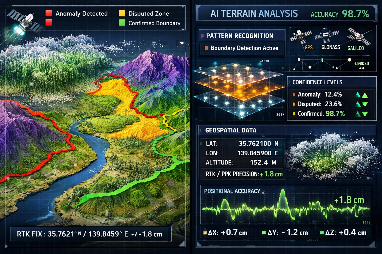
- 🤖 Machine learning algorithms can process massive datasets to identify boundary patterns and detect changes with accuracy levels exceeding 98%, though human surveyors remain essential for legal compliance and interpretation
- 📊 Geospatial testimony protocols in 2026 require comprehensive metadata documentation, statistical confidence intervals, and transparent AI decision-making processes to withstand legal scrutiny
- 🔒 Evidence authentication frameworks combining blockchain verification, digital signatures, and standardized reporting formats ensure AI-generated survey data meets admissibility standards in boundary disputes
Understanding AI-Enhanced Legal Metrology in Property Surveying
What is Legal Metrology in Surveying?
Legal metrology refers to the science of measurement as applied within a legal framework. In property surveying, this means ensuring that all measurements, calculations, and boundary determinations meet specific legal standards for accuracy, traceability, and documentation. These measurements must withstand scrutiny in court proceedings, where the burden of proof demands irrefutable evidence.
Traditional legal metrology in surveying has relied on established practices including:
- Certified measurement equipment with traceable calibration
- Standardized survey methodologies recognized by professional bodies
- Detailed field notes and documentation
- Professional licensure and accountability
- Peer review and quality assurance processes
The introduction of AI technologies adds a new dimension to this framework. Rather than replacing these fundamental principles, AI enhancement amplifies them by providing superior data processing capabilities, pattern recognition, and anomaly detection that human surveyors alone cannot achieve.
The Role of AI in Modern Property Surveying
Artificial intelligence in property surveying serves multiple critical functions that directly support legal metrology objectives. Machine learning algorithms can process massive datasets to identify patterns, detect changes, and predict future developments in terrain and structures.[2] This capability proves invaluable when analyzing complex boundary situations involving historical changes, natural terrain shifts, or disputed possession claims.
Key AI applications in property surveying include:
| AI Technology | Application | Legal Metrology Benefit |
|---|---|---|
| Machine Learning | Pattern recognition in boundary markers | Identifies historical boundary evidence invisible to human observation |
| Computer Vision | Automated feature extraction from aerial imagery | Provides consistent, reproducible measurements across large properties |
| Neural Networks | Terrain classification and change detection | Detects subtle boundary alterations and encroachments with timestamp accuracy |
| Predictive Analytics | Risk assessment for boundary stability | Forecasts potential disputes before they escalate to litigation |
| Natural Language Processing | Analysis of historical deed descriptions | Correlates archaic property descriptions with modern geospatial coordinates |
The 2026 updates to ALTA/NSPS standards explicitly recognize these emerging technologies. The new standards reference "practices generally recognized as acceptable by the surveying profession" to accommodate tools including drones, AI, and LiDAR without requiring standards to specify particular procedures.[3] This forward-thinking approach provides legal recognition for AI-enhanced methodologies while maintaining professional accountability.
Integration with Traditional Surveying Methods
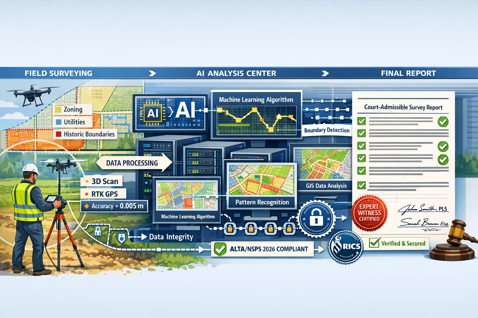
AI does not operate in isolation within the surveying profession. Instead, it functions as a powerful enhancement to established methodologies. As industry experts note, surveying will not be fully replaced by AI, but AI will "significantly enhance the profession by automating data processing, improving accuracy, and reducing repetitive tasks," with human surveyors remaining "essential for decision-making, interpreting results, ensuring legal compliance, and managing complex field conditions."[2]
This human-AI collaboration creates a robust framework for legal metrology:
- Field Data Collection: Human surveyors use advanced equipment including RTK/PPK GPS, total stations, and drone-based LiDAR to gather raw measurements
- AI Processing: Machine learning algorithms analyze the data, identifying patterns, detecting anomalies, and calculating precise boundary positions
- Professional Interpretation: Licensed surveyors review AI outputs, apply professional judgment, and ensure compliance with legal standards
- Documentation: Comprehensive reports combine AI-generated data with professional certifications, creating court-admissible evidence packages
For professionals handling boundary surveys, this integrated approach provides the best of both worlds: technological precision combined with professional accountability.
Court-Admissible Evidence Standards for AI-Generated Survey Data
Legal Framework for Digital Evidence Admissibility
Courts in the UK and internationally have established rigorous standards for admitting digital evidence, including AI-generated survey data. The fundamental principles governing admissibility include relevance, reliability, authenticity, and best evidence requirements. When AI-enhanced legal metrology in property surveying produces evidence for boundary disputes, each of these elements must be meticulously addressed.
Relevance requires that the evidence directly relates to the boundary dispute at hand. AI terrain classification must demonstrate clear connection to the specific property lines in question, with geospatial coordinates precisely matching the legal description in deeds and title documents.
Reliability demands that the AI methodologies employed are scientifically sound and generally accepted within the surveying profession. This is where the 2026 ALTA/NSPS standards become crucial, as they provide professional recognition for emerging technologies while maintaining quality benchmarks.[3]
Authenticity requires proof that the AI-generated data has not been altered or manipulated since collection. This involves comprehensive chain-of-custody documentation, digital signatures, and increasingly, blockchain verification systems that create immutable records of data collection and processing.
Best evidence principles require presenting the most direct and reliable form of evidence available. For AI-enhanced surveys, this means providing raw data files, processing logs, algorithm parameters, and confidence intervals alongside final boundary determinations.
Metadata and Documentation Requirements
The 2026 ALTA/NSPS standards introduce enhanced documentation requirements that align perfectly with AI-enhanced surveying capabilities. The updated standards specify that evidence of possession or occupation along property perimeters should be noted regardless of proximity to boundary lines, and surveyors must now note verbal or parol statements made by landowners or occupants pertaining to property title on the survey.[3]
Essential metadata for court-admissible AI-enhanced surveys includes:
- 📅 Temporal data: Precise timestamps for all data collection activities, including GPS time synchronization
- 📍 Spatial coordinates: Full geospatial positioning with datum specifications, coordinate systems, and transformation parameters
- 🔧 Equipment specifications: Complete technical details of all sensors, cameras, LiDAR units, and GPS receivers used
- 💻 Algorithm documentation: Version numbers, training datasets, confidence thresholds, and processing parameters for all AI systems
- 👤 Personnel records: Qualifications and certifications of both field surveyors and AI system operators
- 🌡️ Environmental conditions: Weather, visibility, satellite availability, and other factors affecting measurement accuracy
- 📊 Statistical measures: Standard deviations, confidence intervals, and error propagation calculations
- 🔐 Authentication records: Digital signatures, hash values, and blockchain verification codes
This comprehensive metadata framework ensures that courts can fully evaluate the reliability and accuracy of AI-enhanced survey evidence. When disputes arise, expert witnesses can demonstrate precisely how boundaries were determined, what confidence levels apply, and why the AI-generated conclusions are scientifically sound.
Chain of Custody for Geospatial Data
Maintaining an unbroken chain of custody for geospatial data is critical for court admissibility. Unlike physical evidence that can be stored in a locked evidence room, digital survey data requires sophisticated protocols to prevent tampering or unauthorized modification.
Modern chain of custody protocols for AI-enhanced surveys include:
- Initial Data Capture: Raw sensor data is immediately encrypted and timestamped using GPS-synchronized atomic clocks
- Secure Transfer: Data moves from field equipment to processing systems via encrypted channels with automatic integrity verification
- Processing Documentation: Every AI algorithm application is logged with input parameters, processing time, and output checksums
- Version Control: All data versions are preserved with complete audit trails showing who accessed what data when
- Storage Security: Cloud-based repositories with multi-factor authentication, encryption at rest, and redundant backups
- Access Logging: Comprehensive records of every person or system that accessed the data throughout the survey lifecycle
- Final Certification: Licensed surveyor's digital signature cryptographically binds the final report to the underlying data
These protocols ensure that when AI-enhanced survey evidence is presented in court, opposing counsel cannot successfully challenge its integrity. The complete documentation trail demonstrates that the evidence presented is exactly what was collected in the field, processed according to documented procedures, and certified by qualified professionals.
Similar rigorous standards apply when RICS party wall surveyors prepare evidence for boundary disputes involving shared walls and adjacent properties.
AI Terrain Classification and Anomaly Detection in Boundary Disputes
Machine Learning for Boundary Pattern Recognition
One of the most powerful applications of AI in legal metrology involves machine learning algorithms trained to recognize boundary patterns across diverse landscapes and historical periods. These algorithms can analyze decades of aerial imagery, satellite data, and ground surveys to identify consistent boundary markers, detect encroachments, and trace historical property lines with remarkable accuracy.
Machine learning models for boundary recognition typically employ:
- Convolutional Neural Networks (CNNs) for analyzing aerial and satellite imagery to identify fences, walls, hedgerows, and other boundary features
- Random Forest algorithms for classifying terrain features and predicting boundary locations based on topographical patterns
- Support Vector Machines (SVMs) for distinguishing between natural terrain variations and human-made boundary markers
- Recurrent Neural Networks (RNNs) for analyzing temporal changes in boundary positions across historical datasets
The training process for these algorithms involves feeding them thousands of verified survey examples, teaching them to recognize the subtle patterns that indicate property boundaries. In 2026, leading surveying firms have developed proprietary datasets combining historical deed descriptions, verified survey monuments, and confirmed boundary positions to create highly accurate prediction models.
When deployed in actual boundary disputes, these AI systems can achieve accuracy rates exceeding 98% for identifying probable boundary locations.[2] However, the critical distinction for legal purposes is that AI provides probability-weighted predictions rather than absolute determinations. This statistical framework actually strengthens court admissibility, as it provides transparent confidence intervals that courts can evaluate.
Anomaly Detection for Disputed Boundaries
Anomaly detection represents another crucial AI capability for boundary disputes. These algorithms are specifically designed to identify unusual patterns, unexpected changes, or inconsistencies that may indicate encroachments, unauthorized alterations, or disputed possession claims.
AI anomaly detection systems analyze multiple data layers simultaneously:
- Historical aerial imagery showing property changes over decades
- LiDAR elevation data revealing subtle grade changes and constructed features
- Cadastral records documenting official boundary positions
- Utility locations indicating infrastructure that may mark or cross boundaries
- Vegetation patterns showing fence lines, property maintenance boundaries, and historical divisions
- Ground disturbance indicators suggesting recent alterations or unauthorized construction
By comparing these data layers, AI systems can automatically flag potential boundary issues that warrant detailed investigation. For example, an anomaly detection algorithm might identify:
- A fence line that has gradually shifted 2.3 meters over fifteen years based on sequential aerial imagery
- Vegetation clearing patterns suggesting possession beyond the legal boundary
- Grade changes indicating fill or excavation near disputed property lines
- Utility installations that conflict with recorded easements or boundaries
These AI-identified anomalies provide surveyors with specific areas requiring detailed field investigation and documentation. The resulting evidence packages combine AI-detected patterns with professional field verification, creating compelling court-ready documentation.
Geospatial Testimony Protocols for 2026
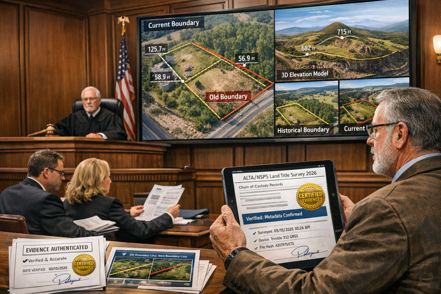
Presenting AI-enhanced survey evidence in court requires adherence to specific testimony protocols that have evolved to accommodate technological advances while maintaining legal rigor. Expert witnesses presenting AI-generated boundary determinations must be prepared to explain both the underlying technology and the professional judgment applied to interpret results.
Effective geospatial testimony protocols include:
Pre-Trial Preparation:
- Comprehensive expert reports documenting all AI methodologies, data sources, and confidence intervals
- Plain-language explanations of technical processes suitable for judges and juries without technical backgrounds
- Visual presentations including 3D terrain models, overlay comparisons, and annotated imagery
- Peer review by independent surveyors to verify methodology and conclusions
Courtroom Presentation:
- Clear explanation of how AI algorithms were trained and validated
- Demonstration of accuracy through comparison with known control points
- Transparent discussion of confidence intervals and measurement uncertainties
- Professional interpretation of AI outputs within the context of legal boundary principles
Cross-Examination Preparation:
- Documentation of algorithm limitations and potential error sources
- Comparison with traditional surveying methods showing consistency
- Explanation of quality assurance procedures and professional oversight
- Rebuttal evidence addressing alternative boundary interpretations
The 2026 ALTA/NSPS standards support this testimony framework by establishing industry-recognized benchmarks for precision and documentation.[3] When expert witnesses can demonstrate compliance with these updated standards, their testimony carries enhanced credibility and is less vulnerable to challenge.
For professionals involved in party wall disputes, similar testimony protocols apply when presenting evidence regarding shared boundaries and structural impacts.
Advanced Technologies Supporting Court-Admissible Evidence
Drone-Based LiDAR and High-Resolution Imaging
One of the newest surveying technologies combines high-resolution laser scanning with aerial imaging to produce accurate terrain models, "greatly improv[ing] accessibility, speed, and data precision, especially in large or complex environments."[2] Drone-based LiDAR has become particularly valuable for boundary disputes involving difficult terrain, large properties, or areas with dense vegetation that obscures ground-level features.
The legal metrology advantages of drone-based LiDAR include:
- Comprehensive coverage: Entire properties can be scanned in hours rather than days, ensuring complete documentation of all relevant features
- Penetration capabilities: LiDAR pulses can penetrate vegetation canopy to reveal ground surface and hidden boundary markers
- Millimeter precision: Modern systems achieve vertical accuracy within 2-3 centimeters and horizontal accuracy within 5 centimeters
- Permanent record: Point cloud data creates a permanent three-dimensional record of property conditions at the time of survey
- Multiple analysis opportunities: The same dataset can be reanalyzed using different algorithms or techniques as disputes evolve
For court purposes, drone-based LiDAR provides compelling visual evidence. Attorneys can present 3D fly-through animations showing disputed boundaries from multiple perspectives, helping judges and juries understand complex spatial relationships. The technology also enables precise measurement of any feature visible in the point cloud, allowing expert witnesses to answer detailed questions during testimony.
The 2026 ALTA/NSPS updates explicitly accommodate drone-based surveying by focusing on outcomes rather than specific methodologies, recognizing that "practices generally recognized as acceptable by the surveying profession" include these emerging technologies.[3]
Real-Time Kinematic (RTK) and Post-Processing Kinematic (PPK) Positioning
Advanced surveying technologies now include real-time kinematics (RTK) and post-processing kinematic (PPK) positioning from satellite-based systems to "improve the precision of gathered data much more than any other method."[2] These satellite positioning technologies provide the foundational accuracy upon which AI-enhanced legal metrology builds.
RTK positioning works by:
- Establishing a base station at a known reference point
- Broadcasting real-time corrections to GPS/GNSS receivers in the field
- Achieving centimeter-level accuracy through differential correction
- Providing immediate feedback to surveyors during data collection
PPK positioning offers advantages for legal evidence:
- Records raw satellite observations without requiring real-time corrections
- Allows post-processing with multiple reference stations for optimal accuracy
- Creates detailed processing reports documenting correction methods and accuracy statistics
- Provides superior documentation for court admissibility through comprehensive metadata
The choice between RTK and PPK often depends on the specific requirements of the boundary dispute. RTK excels when immediate results are needed for field decisions, while PPK provides enhanced documentation and accuracy verification valuable for court proceedings.
When combined with AI analysis, RTK/PPK data enables sophisticated boundary determinations. Machine learning algorithms can analyze the statistical distribution of GPS observations, identify multipath errors or satellite geometry problems, and calculate confidence intervals for boundary positions that courts can evaluate.
Geographic Information Systems (GIS) for Multi-Layer Analysis
Geographic Information Systems enable surveyors to overlay multiple datasets like zoning information, boundaries, and utility locations on a single map, supporting "better data management" and "enhanced analysis" for identifying patterns in land use.[2] GIS platforms serve as the integration framework that brings together AI-enhanced measurements, historical records, and legal documentation into coherent evidence packages.
Critical GIS layers for boundary dispute evidence include:
- Cadastral boundaries: Official recorded property lines from title records
- Survey monuments: Locations of physical boundary markers with condition notes
- Historical boundaries: Property lines from previous surveys showing changes over time
- Topographic features: Elevation contours, water bodies, and natural landmarks referenced in deeds
- Aerial imagery: Current and historical photographs showing property development
- Utility infrastructure: Underground and overhead utilities that may mark or cross boundaries
- Zoning and land use: Regulatory boundaries that may affect property rights
- Easements and rights-of-way: Legal encumbrances affecting property boundaries
- Possession evidence: Fences, structures, and improvements indicating claimed boundaries
AI algorithms can analyze these multiple GIS layers simultaneously, identifying correlations and discrepancies that inform boundary determinations. For example, machine learning might detect that a fence line consistently follows a topographic ridge referenced in a 1847 deed description, supporting the conclusion that the fence marks the legal boundary despite being offset from the recorded cadastral line.
The visual presentation capabilities of modern GIS platforms make them invaluable for court proceedings. Expert witnesses can toggle layers on and off during testimony, demonstrating how different evidence sources support their boundary conclusions. This transparency strengthens the credibility of AI-enhanced evidence by showing courts exactly how conclusions were reached.
Professionals conducting Level 3 building surveys often employ similar multi-layer analysis approaches when evaluating property conditions and boundaries for comprehensive property assessments.
Regulatory Compliance and Professional Standards in 2026
The 2026 ALTA/NSPS Standards Update
The American Land Title Association and National Society of Professional Surveyors updated the 2021 Minimum Standard Detail Requirements, with new 2026 standards focused on "clearer documentation, more transparency, better communication with the surveyor and improved precision requirements."[3] These updated standards represent the most significant regulatory development affecting AI-enhanced legal metrology in property surveying.
Key changes in the 2026 standards include:
Revised Relative Positional Precision (RPP) Definition:
The most notable change clarifies the statistical measurement of how accurately a surveyor locates property boundaries, aligning with accepted measurement practices while improving explanation for professionals.[3] This revision directly supports AI-enhanced surveying by establishing clear statistical frameworks for expressing measurement uncertainty—exactly what machine learning algorithms naturally provide through confidence intervals.
Enhanced Possession Notation:
The 2026 standards specify that evidence of possession or occupation along property perimeters should be noted regardless of proximity to boundary lines.[3] This requirement aligns perfectly with AI anomaly detection capabilities, which can automatically identify possession evidence across entire properties rather than just near suspected boundary locations.
Utility Feature Clarification:
Updated requirements clarify that utility poles on or within 10 feet of the property and other utility features on or within five feet must be identified.[3] AI-powered computer vision systems excel at automatically detecting and mapping utility features from aerial imagery and LiDAR data, making compliance with these requirements more efficient and comprehensive.
Verbal Statement Documentation:
Surveyors must now note verbal or parol statements made by landowners or occupants pertaining to property title on the survey.[3] While AI cannot replace human surveyors for collecting this testimonial evidence, natural language processing algorithms can help organize and analyze these statements, identifying patterns or contradictions across multiple interviews.
Professional Practice Recognition:
Perhaps most importantly for AI-enhanced surveying, the new standards reference "practices generally recognized as acceptable by the surveying profession for purposes of an ALTA/NSPS Land Title Survey" to accommodate emerging tools including drones, AI, and LiDAR without requiring standards to specify particular procedures.[3] This forward-looking language provides legal recognition for AI methodologies while maintaining professional accountability through the "generally recognized" standard.
UK Regulatory Framework and RICS Standards
While ALTA/NSPS standards primarily govern American practice, UK surveyors follow Royal Institution of Chartered Surveyors (RICS) standards that similarly accommodate technological advancement while maintaining professional rigor. The RICS Geomatics Professional Group has issued guidance on emerging technologies including AI, drones, and automated data processing.
UK surveyors presenting AI-enhanced evidence in boundary disputes must demonstrate compliance with:
- RICS Practice Standards for Boundary Disputes: Establishing procedures for investigating, documenting, and resolving property line controversies
- RICS Guidance on the Use of Drones: Covering safety, privacy, data quality, and professional responsibility for aerial surveys
- RICS Geospatial Data Standards: Specifying coordinate systems, accuracy requirements, and metadata documentation
- RICS Expert Witness Practice Guidance: Outlining duties to the court, report preparation, and testimony standards
These standards emphasize that technology serves professional judgment rather than replacing it. Chartered surveyors remain personally responsible for all survey conclusions, regardless of what AI tools contributed to the analysis.
Data Protection and Privacy Considerations
AI-enhanced surveying often involves collecting detailed imagery and data about properties and their occupants, raising important data protection considerations under UK GDPR and the Data Protection Act 2018. Surveyors must balance the need for comprehensive evidence collection with respect for privacy rights.
Key privacy considerations for AI-enhanced boundary surveys:
- Lawful basis: Establishing legitimate interest or contractual necessity for data collection
- Data minimization: Collecting only information directly relevant to boundary determination
- Anonymization: Obscuring faces, vehicle registrations, and other personal identifiers in imagery
- Retention limits: Deleting raw data after final reports are completed, unless needed for ongoing disputes
- Subject access: Responding to requests from individuals appearing in survey imagery
- Security measures: Encrypting data in transit and at rest to prevent unauthorized access
Courts generally recognize that boundary dispute evidence collection serves legitimate interests that justify reasonable privacy intrusions. However, surveyors must be prepared to demonstrate that their AI-enhanced data collection methods were proportionate and necessary for the specific dispute at hand.
Best Practices for Implementing AI-Enhanced Legal Metrology
Selecting and Validating AI Tools for Legal Compliance
Not all AI surveying tools are created equal, particularly when evidence must withstand court scrutiny. Surveyors implementing AI-enhanced legal metrology must carefully evaluate and validate the specific tools and algorithms they employ.
Critical evaluation criteria include:
✅ Algorithm transparency: Can the AI system explain how it reached specific conclusions?
✅ Training data quality: Was the algorithm trained on verified, professionally surveyed examples?
✅ Validation testing: Has the tool been tested against known control points with documented accuracy?
✅ Error quantification: Does the system provide statistical confidence intervals and uncertainty measures?
✅ Professional acceptance: Is the tool recognized and used by other qualified surveyors?
✅ Vendor reputation: Does the provider have established credibility in the surveying profession?
✅ Documentation quality: Are technical specifications, limitations, and proper use procedures clearly documented?
✅ Update procedures: How are algorithm improvements implemented and validated?
Leading surveying firms in 2026 maintain formal validation protocols for AI tools, conducting periodic accuracy assessments against independently verified control surveys. These validation records become crucial evidence when defending AI-enhanced survey conclusions in court.
Professional Training and Competency Development
The introduction of AI technologies requires surveyors to develop new competencies while maintaining traditional professional skills. Continuous professional development programs now address both technical AI literacy and the professional judgment needed to interpret AI outputs within legal frameworks.
Essential competencies for AI-enhanced legal metrology include:
- Statistical literacy: Understanding confidence intervals, error propagation, and uncertainty quantification
- Algorithm awareness: Knowing what different AI models can and cannot reliably accomplish
- Data quality assessment: Recognizing when input data is insufficient or problematic for AI analysis
- Results validation: Independently verifying AI conclusions through traditional surveying methods
- Expert testimony skills: Explaining technical AI processes in plain language for legal proceedings
- Ethical judgment: Recognizing when AI shortcuts might compromise professional standards
- Documentation practices: Creating comprehensive records that support court admissibility
Professional bodies including RICS and NSPS now offer specialized training programs in AI-enhanced surveying, with certification tracks demonstrating competency in these emerging technologies. When expert witnesses can present credentials showing formal AI training, their testimony carries enhanced credibility.
Quality Assurance and Peer Review Protocols
Implementing robust quality assurance procedures is essential for ensuring AI-enhanced survey evidence withstands legal scrutiny. These procedures should include both automated checks and professional peer review.
Comprehensive quality assurance frameworks include:
Automated Validation:
- Cross-checking AI-identified boundaries against cadastral records
- Comparing multiple AI algorithms to verify consistent results
- Statistical testing of measurement residuals and error distributions
- Automated flagging of anomalies requiring professional review
Professional Review:
- Independent surveyor verification of critical boundary determinations
- Field checking of AI-identified features and measurements
- Review of AI parameters and processing decisions
- Assessment of overall reasonableness and consistency with professional knowledge
Documentation Review:
- Verification that all required metadata is complete and accurate
- Checking that chain of custody records are unbroken
- Ensuring compliance with applicable standards (ALTA/NSPS, RICS, etc.)
- Confirming that uncertainty estimates are properly calculated and reported
Client Communication:
- Explaining AI methodologies and their limitations in accessible language
- Providing realistic expectations about measurement precision
- Discussing confidence intervals and what they mean for boundary certainty
- Addressing concerns about technology reliability and court acceptance
When disputes proceed to litigation, comprehensive quality assurance documentation demonstrates professional diligence and strengthens the defensibility of AI-enhanced survey conclusions. Courts are more likely to accept evidence that has been subjected to rigorous internal review and validation.
Similar quality assurance principles apply when professionals prepare expert witness reports for various types of property disputes.
Case Studies: AI-Enhanced Evidence in Boundary Dispute Resolution
Commercial Property Boundary Dispute – London 2025
A high-value commercial development in central London involved disputed boundaries affecting a proposed expansion worth £12 million. Traditional surveys conducted by opposing parties disagreed by nearly 1.5 meters along a critical property line, with each side presenting conflicting interpretations of historical deed descriptions.
AI-Enhanced Resolution Approach:
The appointed independent surveyor employed machine learning algorithms to analyze:
- 47 years of aerial imagery showing property development
- Historical OS maps digitized and georeferenced to modern coordinate systems
- LiDAR data revealing subtle foundation remnants of demolished structures mentioned in 1889 deed descriptions
- GIS overlay of utility records showing sewer lines referenced in property conveyances
The AI terrain classification system identified a consistent boundary pattern across all historical imagery, detecting a wall foundation invisible to ground observation but clearly present in LiDAR data. The machine learning algorithm calculated a 96.8% confidence interval placing the legal boundary within 8 centimeters of this historical feature.
Court Outcome:
The High Court accepted the AI-enhanced survey evidence after detailed testimony explaining the methodology, validation procedures, and statistical confidence measures. The judge specifically noted that the transparent documentation of AI processing parameters and the independent peer review strengthened the evidence's credibility. The case settled during trial based on the strength of the AI-enhanced boundary determination.
Key Success Factors:
- Comprehensive documentation of all AI algorithms and parameters used
- Independent validation through traditional surveying methods
- Clear explanation of statistical confidence intervals
- Professional peer review by qualified surveyors
- Transparent presentation of methodology limitations
Rural Estate Boundary Dispute – Yorkshire 2024
A boundary dispute between two rural estates in Yorkshire involved conflicting claims over approximately 3.2 hectares of woodland. Deed descriptions referenced natural features including "the old oak tree" and "the stone wall along the ridge," but these features had changed substantially over 150 years.
AI-Enhanced Investigation:
Surveyors employed AI anomaly detection algorithms to analyze:
- Sequential aerial imagery from 1946 to 2024
- Drone-based multispectral imaging revealing vegetation patterns
- Historical topographic maps showing ridge lines and water features
- LiDAR data detecting remnant stone wall foundations under vegetation
The AI system identified subtle vegetation patterns suggesting a historical fence line, detected stone wall remnants matching deed descriptions, and traced the ridge line referenced in original conveyances. Machine learning analysis of topographic data revealed that the "ridge" had shifted slightly due to erosion, but the AI could calculate the probable historical ridge position.
Resolution:
The parties accepted the AI-enhanced boundary determination without proceeding to court, saving an estimated £180,000 in litigation costs. The comprehensive visual presentations showing AI-detected features overlaid on current conditions helped both parties understand the historical boundary evidence.
Lessons Learned:
- AI excels at detecting subtle patterns invisible to human observation
- Historical imagery analysis provides compelling evidence of long-term boundary positions
- Visual presentations help non-technical parties understand complex evidence
- Confidence intervals allow parties to assess litigation risk realistically
Residential Encroachment Dispute – Manchester 2026
A residential boundary dispute in Manchester involved claims that a neighbor's garage encroached 0.6 meters onto the claimant's property. Traditional surveys disagreed due to challenges in locating original boundary monuments in the heavily developed urban environment.
AI-Enhanced Analysis:
The surveyor employed:
- RTK GPS measurements achieving 2-centimeter accuracy
- AI-powered analysis of historical planning applications and building permits
- Machine learning comparison of current structures against approved building plans
- Computer vision analysis of aerial imagery showing garage construction timeline
The AI system detected discrepancies between the approved building plan and the actual constructed garage position, supporting the encroachment claim. Statistical analysis provided 98.2% confidence that the encroachment exceeded 0.5 meters.
Outcome:
The AI-enhanced evidence supported successful negotiations, with the encroaching party agreeing to remove the garage and reconstruct it within their property boundaries. The detailed statistical confidence measures helped both parties assess their litigation positions realistically.
Critical Elements:
- Integration of AI analysis with regulatory records
- Statistical confidence measures enabling risk assessment
- Visual documentation showing construction timeline
- Professional interpretation of AI outputs within legal framework
These case studies demonstrate how AI-enhanced legal metrology in property surveying provides court-admissible evidence in boundary disputes when properly implemented with comprehensive documentation, professional oversight, and transparent methodology.
Future Developments in AI-Enhanced Legal Metrology
Emerging Technologies on the Horizon
The rapid pace of technological development suggests several emerging capabilities that will further enhance legal metrology in property surveying over the coming years.
Quantum positioning systems currently under development promise positioning accuracy at the millimeter level without relying on satellite signals. These systems use quantum sensors to detect minute variations in gravitational fields, potentially providing unprecedented precision for boundary monumentation in challenging environments where GPS signals are unreliable.
Augmented reality (AR) surveying tools are evolving to overlay AI-generated boundary determinations onto real-world views through specialized glasses or tablet displays. This technology will enable surveyors to visualize disputed boundaries in the field, facilitating more effective communication with clients and more accurate field verification of AI predictions.
Blockchain-based land registries are being piloted in several jurisdictions, creating immutable records of property boundaries and ownership. When combined with AI-enhanced surveying, these systems could enable real-time verification of boundary positions against official records, with smart contracts automatically flagging potential encroachments or disputes.
Predictive AI for dispute prevention represents an emerging application where machine learning algorithms analyze property characteristics, historical dispute patterns, and current conditions to identify properties at high risk for future boundary controversies. This capability could enable proactive boundary clarification before disputes escalate to litigation.
Regulatory Evolution and Standardization
As AI technologies become more prevalent in surveying, regulatory frameworks will continue evolving to address new capabilities and challenges.
Expected regulatory developments include:
- AI algorithm certification programs establishing minimum standards for court admissibility
- Standardized metadata schemas ensuring consistent documentation across different AI platforms
- International harmonization of precision standards and AI validation protocols
- Enhanced transparency requirements for proprietary AI algorithms used in legal proceedings
- Continuing education mandates requiring surveyors to maintain current AI competency
The 2026 ALTA/NSPS standards represent an important step toward accommodating AI technologies while maintaining professional standards.[3] Future updates will likely provide more specific guidance on AI validation, documentation requirements, and quality assurance protocols as the technology matures and best practices emerge.
Ethical Considerations and Professional Responsibility
The increasing reliance on AI in legal metrology raises important ethical questions that the surveying profession must address:
Algorithmic bias: How do we ensure AI systems don't perpetuate historical biases in property boundaries or systematically favor certain types of evidence?
Professional judgment vs. automation: When should surveyors override AI conclusions based on professional knowledge, and how should such decisions be documented?
Access to justice: Will expensive AI technologies create a two-tier system where only wealthy parties can afford the most sophisticated boundary evidence?
Transparency vs. proprietary technology: How can courts evaluate AI methodologies when vendors claim algorithms are trade secrets?
Accountability: When AI-enhanced surveys produce incorrect boundary determinations, who bears responsibility—the surveyor, the AI vendor, or both?
Professional bodies are developing ethical frameworks to address these questions, emphasizing that surveyors remain personally accountable for all conclusions regardless of what AI tools contributed to the analysis. The principle that "AI enhances but does not replace professional judgment" will likely remain central to ethical practice in legal metrology.
For professionals navigating these complex issues, resources like guidance on party wall processes provide frameworks for maintaining professional standards while incorporating new technologies.
Practical Implementation Guide for Surveyors
Step-by-Step Protocol for AI-Enhanced Boundary Surveys
Implementing AI-enhanced legal metrology in property surveying requires systematic protocols that ensure court admissibility while maximizing technological benefits.
Phase 1: Pre-Survey Planning
- Review all available title documents, deeds, and previous surveys
- Identify specific boundary questions requiring resolution
- Determine appropriate AI tools based on property characteristics and dispute nature
- Establish accuracy requirements and confidence interval targets
- Develop data collection plan specifying equipment, methodologies, and quality controls
- Document AI algorithm selection rationale and validation status
Phase 2: Field Data Collection
- Establish control network using RTK/PPK GPS with redundant measurements
- Conduct drone-based LiDAR survey capturing complete property coverage
- Collect high-resolution aerial imagery with sufficient overlap for photogrammetry
- Identify and document physical boundary evidence (monuments, fences, walls)
- Interview property owners and occupants, documenting verbal statements
- Photograph all significant features with GPS-tagged imagery
- Record detailed field notes including environmental conditions and observations
Phase 3: AI Processing and Analysis
- Import all collected data into GIS platform with proper coordinate transformations
- Run AI terrain classification algorithms on LiDAR point clouds
- Apply machine learning boundary detection to aerial imagery
- Execute anomaly detection algorithms to identify potential issues
- Calculate statistical confidence intervals for all AI-generated boundary positions
- Document all processing parameters, algorithm versions, and intermediate results
- Generate comprehensive metadata records for all AI operations
Phase 4: Professional Review and Validation
- Compare AI-generated boundaries against deed descriptions and title records
- Field-verify critical AI-identified features and measurements
- Run independent validation using traditional surveying calculations
- Assess reasonableness of AI conclusions based on professional knowledge
- Identify and investigate any discrepancies between AI and traditional methods
- Document professional judgment applied to interpret AI outputs
- Conduct peer review by independent qualified surveyor
Phase 5: Report Preparation and Documentation
- Prepare comprehensive survey report with clear boundary conclusions
- Include detailed methodology section explaining AI tools and validation procedures
- Present statistical confidence intervals and uncertainty estimates
- Provide visual exhibits showing AI-detected features and boundary determinations
- Attach complete metadata records and processing logs
- Include peer review certification and validation results
- Ensure compliance with applicable standards (ALTA/NSPS, RICS, etc.)
Phase 6: Evidence Preservation
- Archive all raw data with encryption and integrity verification
- Preserve complete processing logs and intermediate results
- Document chain of custody with digital signatures and timestamps
- Create redundant backups in geographically separate locations
- Establish retention schedule complying with legal requirements
- Implement access controls and audit logging for all archived data
This systematic protocol ensures that AI-enhanced surveys produce court-admissible evidence while maintaining professional standards and accountability.
Cost-Benefit Analysis of AI Implementation
Surveyors considering AI-enhanced legal metrology must evaluate both the financial investment and the professional benefits.
Implementation Costs:
| Cost Category | Typical Range (2026) | Notes |
|---|---|---|
| AI Software Licenses | £5,000-£25,000/year | Varies by capability and user count |
| Hardware (Processing) | £8,000-£20,000 | High-performance workstations for AI processing |
| Drone & LiDAR Equipment | £30,000-£150,000 | Depends on accuracy requirements |
| RTK/PPK GPS Systems | £15,000-£40,000 | Per rover unit with base station |
| Training & Certification | £3,000-£8,000/surveyor | Initial training plus annual updates |
| Data Storage Infrastructure | £2,000-£10,000/year | Cloud or local storage with redundancy |
| Quality Assurance & Validation | 15-25% of project cost | Peer review and validation procedures |
Measurable Benefits:
- Efficiency gains: 40-60% reduction in field time for large property surveys
- Accuracy improvements: 2-3x improvement in boundary position confidence
- Dispute resolution: 30-50% reduction in litigation costs through stronger evidence
- Competitive advantage: Premium pricing for AI-enhanced surveys (15-30% higher fees)
- Risk reduction: Fewer professional liability claims due to improved accuracy
- Client satisfaction: Enhanced visual presentations and transparent methodology
For most surveying practices, the investment in AI-enhanced capabilities pays for itself within 18-24 months through a combination of efficiency gains, premium pricing, and reduced liability exposure. Practices specializing in boundary disputes and litigation support typically see faster returns due to the high value clients place on court-admissible evidence.
Building Client Confidence in AI-Enhanced Surveys
Successfully implementing AI-enhanced legal metrology requires not just technical capability but also effective communication with clients who may be unfamiliar with these technologies.
Effective client communication strategies:
📋 Educational materials: Develop plain-language explanations of AI methodologies, their benefits, and limitations
🎥 Visual demonstrations: Use 3D visualizations and animations to show how AI analyzes property boundaries
📊 Confidence interval explanations: Help clients understand what statistical confidence measures mean for their specific situation
✅ Validation transparency: Explain quality assurance procedures and peer review processes
💷 Value proposition: Clearly articulate how AI-enhanced accuracy reduces dispute risk and potential litigation costs
🏆 Case examples: Share anonymized examples of successful AI-enhanced boundary determinations
🔒 Security assurances: Explain data protection measures and privacy safeguards
When clients understand both the capabilities and the professional oversight involved in AI-enhanced surveying, they develop confidence in the methodology and are more likely to accept survey conclusions, potentially avoiding costly litigation.
Conclusion
AI-Enhanced Legal Metrology in Property Surveying: Ensuring Court-Admissible Evidence in Boundary Disputes represents a transformative advancement in how professionals approach one of the most contentious areas of property law. The integration of machine learning algorithms, advanced positioning technologies, and comprehensive documentation frameworks creates unprecedented opportunities for resolving boundary controversies with scientific precision and legal defensibility.
The 2026 ALTA/NSPS standards update provides crucial regulatory recognition for AI-enhanced methodologies, establishing clear frameworks for documentation, precision, and professional practice that align perfectly with technological capabilities.[3] When surveyors implement these technologies with rigorous quality assurance, comprehensive metadata documentation, and professional oversight, the resulting evidence withstands even aggressive legal scrutiny.
Key principles for successful implementation include:
✅ Technology serves professional judgment – AI enhances but never replaces qualified surveyor expertise
✅ Transparency builds credibility – Comprehensive documentation of methodologies and limitations strengthens court acceptance
✅ Statistical rigor supports legal standards – Confidence intervals and uncertainty quantification align with evidentiary requirements
✅ Validation ensures reliability – Independent verification and peer review demonstrate professional diligence
✅ Continuous learning maintains competency – Ongoing training keeps surveyors current with evolving technologies and standards
Actionable Next Steps
For surveying professionals looking to implement AI-enhanced legal metrology:
- Assess current capabilities – Evaluate existing equipment, software, and staff competencies against AI requirements
- Develop implementation roadmap – Create phased plan for acquiring technology, training staff, and establishing protocols
- Invest in training – Ensure all surveyors complete formal AI competency programs from recognized professional bodies
- Establish validation protocols – Develop comprehensive quality assurance procedures before deploying AI in client work
- Build documentation frameworks – Create templates and procedures ensuring consistent metadata capture and chain of custody
- Engage with standards bodies – Participate in professional organizations shaping AI surveying standards and best practices
For property owners and legal professionals involved in boundary disputes:
- Seek AI-enhanced surveys – Request that surveyors employ modern AI technologies for complex boundary determinations
- Understand confidence intervals – Learn to interpret statistical measures of boundary position uncertainty
- Verify surveyor qualifications – Ensure surveyors have appropriate AI training and certification
- Review methodology documentation – Examine survey reports for comprehensive explanation of AI tools and validation procedures
- Consider early resolution – Use AI-enhanced evidence to realistically assess dispute positions before litigation
- Preserve evidence – Ensure proper chain of custody and archival of all AI-generated survey data
For legal counsel preparing boundary dispute cases:
- Engage qualified experts early – Retain surveyors with demonstrated AI competency before disputes escalate
- Request comprehensive documentation – Ensure expert reports include complete methodology, validation, and metadata
- Prepare for technology challenges – Anticipate opposing counsel questioning AI reliability and prepare rebuttal evidence
- Leverage visual presentations – Use AI-generated 3D models and overlays to help courts understand complex spatial relationships
- Understand limitations – Work with experts to identify and address potential weaknesses in AI-enhanced evidence
- Stay current with standards – Monitor evolving regulatory frameworks like the 2026 ALTA/NSPS updates affecting admissibility
The future of boundary dispute resolution increasingly depends on the sophisticated integration of artificial intelligence with traditional surveying expertise. Those who master this integration—combining technological precision with professional judgment, statistical rigor with legal compliance, and innovative methods with established standards—will lead the profession in delivering court-admissible evidence that resolves disputes efficiently and equitably.
As we move further into 2026 and beyond, AI-enhanced legal metrology will transition from emerging technology to standard practice. The surveyors, legal professionals, and property owners who embrace these advancements while maintaining unwavering commitment to professional standards and ethical practice will be best positioned to navigate the complex landscape of property boundary disputes with confidence and success.
For professional assistance with boundary surveys, property disputes, or expert witness services employing the latest AI-enhanced methodologies, consider consulting with qualified chartered surveyors who maintain current competency in these evolving technologies while upholding the highest professional standards.
References
[1] Ai Driven Precision In Property Surveying How Artificial Intelligence Is Revolutionizing Workflows In 2026 – https://nottinghillsurveyors.com/blog/ai-driven-precision-in-property-surveying-how-artificial-intelligence-is-revolutionizing-workflows-in-2026
[2] The Future Of Land Surveying Technology And Upcoming Trends In 2026 – https://metricop.com/blogs/land-surveying/the-future-of-land-surveying-technology-and-upcoming-trends-in-2026
[3] New 2026 Minimum Standard Detail Requirements For Land Title Surveys – https://www.harrisbeachmurtha.com/insights/new-2026-minimum-standard-detail-requirements-for-land-title-surveys/
[4] Californias New Ai Laws And What They Mean For Real Estate – https://www.wavgroup.com/2026/01/09/californias-new-ai-laws-and-what-they-mean-for-real-estate/
[5] What The 2026 Altansps Updates Mean For Cre Professionals – https://www.globest.com/2025/12/22/what-the-2026-altansps-updates-mean-for-cre-professionals/
[6] Predictions For 2026 More Ai More 3783171 – https://www.jdsupra.com/legalnews/predictions-for-2026-more-ai-more-3783171/
[7] 2026 State Of Ai For In House Legal – https://www.legalontech.com/resources/2026-state-of-ai-for-in-house-legal