
The surveying industry reached a critical milestone on February 23, 2026, when the updated ALTA/NSPS Minimum Standard Detail Requirements for Land Title Surveys officially took effect[1][4]. As the dust settles on this significant transition, property surveyors across the nation are navigating a transformed landscape of requirements, responsibilities, and best practices. The Post-ALTA/NSPS 2026 Standards Implementation: Challenges and Success Stories for Property Surveyors reveals a fascinating picture of adaptation, innovation, and occasional struggle as firms work to achieve seamless compliance with these comprehensive revisions.
With the February 23 deadline now behind us, surveying professionals are sharing their real-world experiences—both triumphs and setbacks—as they implement these updated standards in their daily operations. The revised requirements, which follow the industry's established five-year revision cycle[2], introduce substantial changes that affect everything from records research protocols to utility documentation methods and encroachment reporting formats.
Key Takeaways
- 📋 Major responsibility shift: Surveyors now handle adjoining property deed research previously managed by title insurers, requiring new workflows and resource allocation
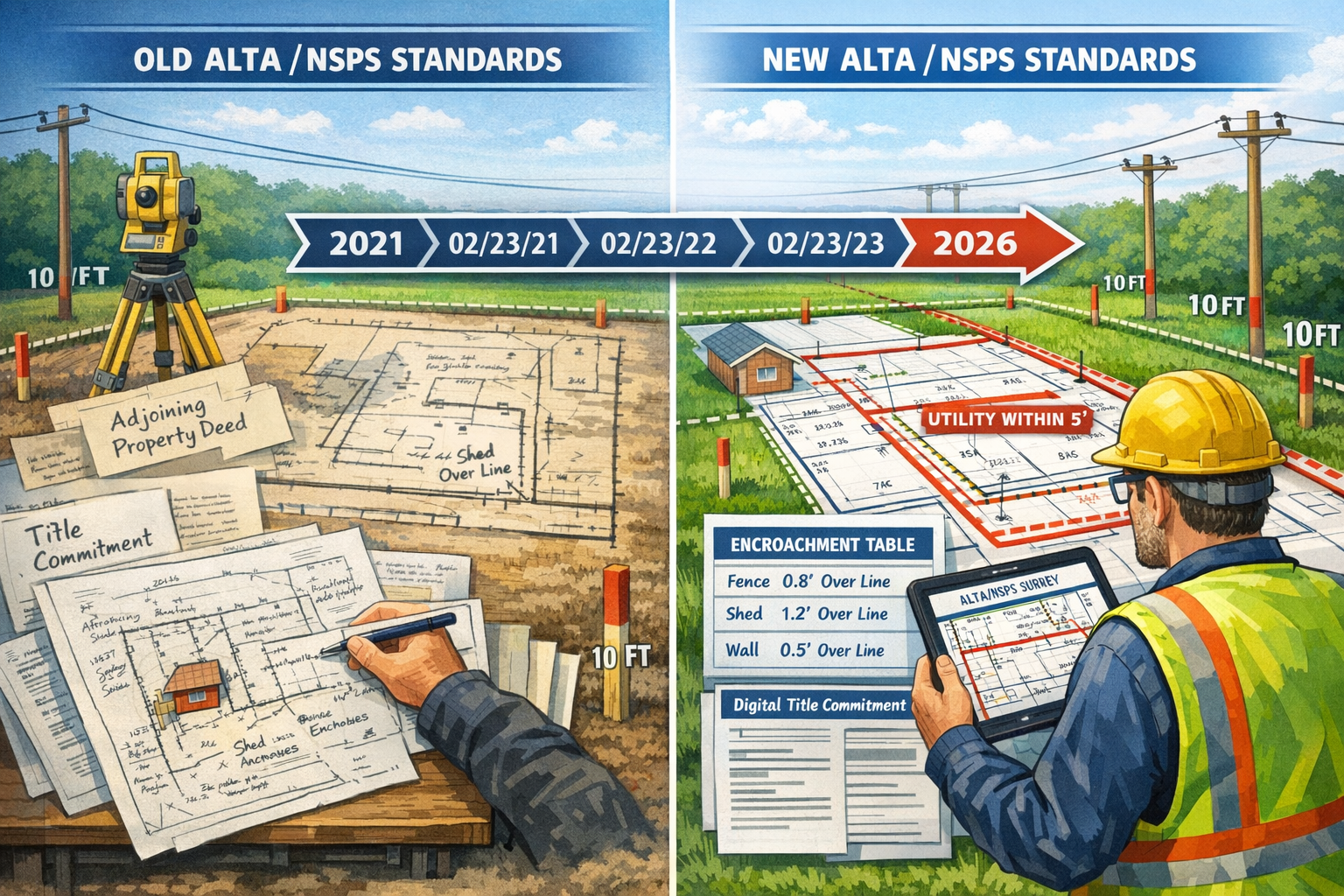
- 📏 Tightened utility documentation: Evidence of utilities must now be documented within five feet of surveyed property (reduced from previous standards), except utility poles which remain at ten feet[3]
- 📊 Structured encroachment reporting: The brand-new Table A Item 20 introduces a dedicated table format for documenting encroachments, replacing traditional narrative notes[3]
- 🤝 Written imagery agreements: Surveyors must now obtain written client approval for imagery use instead of ground surveying for certain features[3]
- ⚡ Implementation urgency: Understanding these changes is critical to avoid miscommunication, coverage gaps, and closing delays[1]
Understanding the 2026 ALTA/NSPS Standards Revisions
The 2026 updates to the ALTA/NSPS Minimum Standard Detail Requirements represent more than minor technical adjustments—they constitute a fundamental reshaping of surveying responsibilities and documentation standards. These revisions aim to improve clarity and consistency while increasing uniformity, transparency, and consistency in survey preparation across the industry[1][4].
The Five-Year Revision Cycle
The ALTA/NSPS standards operate on a predictable five-year revision cycle[2], allowing the industry to anticipate updates and prepare for transitions. This regular cadence ensures that standards evolve alongside technological advances, industry best practices, and changing market needs. The 2026 revision represents the latest iteration in this ongoing evolution, building upon lessons learned from previous implementations.
Key Changes That Define the 2026 Standards
The current revision introduces several transformative changes that directly impact daily surveying operations:
Records Research Requirements (Sections 4.A. and 4.C.i)
Perhaps the most significant shift involves the elimination of the requirement that title insurers provide copies of deeds of adjoining properties[3]. This responsibility now falls squarely on surveyors' shoulders, requiring firms to develop new research capabilities, establish relationships with county records offices, and allocate additional time and resources to each survey project.
Title Evidence Documentation
Surveyors must now receive "a copy of the most recent title commitment or other title evidence satisfactory to the insurer"[3]. This requirement creates a more direct connection between surveyors and title documentation, potentially improving accuracy but also demanding greater familiarity with title documents and their interpretation.
Utilities Documentation (Section 5.E.iv.)
The updated standards tighten utility documentation requirements significantly. Evidence of utilities must now be documented "on and within five feet of the surveyed property," except utility poles, which remain "on and within ten feet"[3]. This change requires more precise field work and potentially more extensive research into utility locations.
Imagery Use (Table A – Item 15)
The revised language "reverts back to its original intent" to allow imagery rather than ground surveying for certain features[3]. However, surveyors must now "agree with the client in writing on imagery to utilize"[3], creating a documentation requirement that protects both parties while offering flexibility in survey methods.
Encroachments Documentation (Table A – Item 20)
A brand-new Table A item creates a dedicated table format for documenting "conditions and potential encroachments"[3]. This structured approach replaces the previous narrative format, standardizing how encroachment information is presented and potentially improving clarity for all stakeholders.
Professional surveyors working across different regions, from chartered surveyors in Central London to those in Hertfordshire, must now adapt their practices to these uniform standards.
Post-ALTA/NSPS 2026 Standards Implementation: Real-World Challenges Faced by Surveyors
The transition to the 2026 standards has not been without significant challenges. Surveying firms of all sizes have encountered obstacles that tested their adaptability, resources, and commitment to compliance.
Challenge #1: Records Research Burden
The Problem: The shift of adjoining property deed research from title insurers to surveyors created immediate workflow disruptions. Many surveying firms lacked established relationships with county records offices, experienced staff for deed research, and systems for efficiently obtaining and reviewing adjoining property documentation.
Real-World Impact: Mid-sized surveying firms reported project timeline extensions of 3-5 business days during the initial implementation period. Smaller firms without dedicated research staff experienced even longer delays, with some projects extending by a full week or more.
Cost Implications: The additional research burden translated directly into increased project costs. Firms needed to either:
- Hire additional staff with records research expertise
- Train existing surveyors in deed research methodologies
- Outsource research to third-party services
- Absorb the additional time within existing fee structures
One surveying firm in Essex reported hiring two part-time researchers specifically to handle the new adjoining property deed requirements, representing a significant operational expense that needed to be factored into project pricing.
Challenge #2: Utility Documentation Precision
The Problem: The tightened requirement for utility documentation within five feet of the surveyed property demanded greater field precision and more comprehensive utility research. Many utilities, particularly older installations, lack precise documentation, making the five-foot requirement challenging to verify with certainty.
Field Work Complications: Surveyors reported several specific difficulties:
- Underground utilities without accurate as-built documentation
- Conflicting information between utility company records and field observations
- Limited access to certain areas for precise measurement
- Weather conditions affecting detection equipment accuracy
Technology Investments: Meeting the new utility documentation standards prompted many firms to invest in advanced detection equipment, including:
- Ground-penetrating radar (GPR) systems
- Electromagnetic locators with enhanced precision
- GPS equipment with sub-centimeter accuracy
- Digital documentation tools for field data capture
These technology investments, while ultimately beneficial, represented substantial upfront costs during an already challenging transition period.
Challenge #3: Written Imagery Agreements
The Problem: The requirement for written client agreements on imagery utilization introduced a new administrative step that many firms initially overlooked or underestimated. Creating standardized agreement templates, educating clients about imagery options, and documenting these agreements added complexity to client intake processes.
Communication Challenges: Surveyors found that many clients didn't understand:
- The difference between ground surveying and imagery-based surveying
- The implications of choosing one method over another
- The cost and timeline differences between approaches
- The accuracy limitations of various imagery sources
This knowledge gap required surveyors to develop educational materials and spend additional time in client consultations, extending project initiation timelines.
Challenge #4: Encroachment Table Implementation
The Problem: Transitioning from narrative encroachment descriptions to the structured Table A Item 20 format required significant changes to reporting templates, software configurations, and surveyor training. The new format, while ultimately clearer, demanded precision in categorization and documentation that differed from traditional narrative approaches.
Software Adaptation: Many surveying firms discovered that their existing survey software didn't accommodate the new table format, requiring:
- Software updates or replacements
- Custom template development
- Staff training on new reporting formats
- Quality control processes to ensure consistent table completion
Challenge #5: Title Evidence Review
The Problem: The requirement to receive and review "a copy of the most recent title commitment or other title evidence satisfactory to the insurer"[3] placed surveyors in a new role of title document interpretation. Many surveyors lacked experience with title commitments and needed training to effectively utilize this information.
Knowledge Gap: Surveyors reported uncertainty about:
- Which elements of title commitments were relevant to survey work
- How to reconcile discrepancies between title evidence and field observations
- When to request clarification from title companies
- How to document title-related findings in survey reports
This challenge highlighted the need for cross-disciplinary knowledge that many surveying programs hadn't traditionally emphasized.
Similar challenges have been observed across various surveying specializations, from building surveys to more specialized work like structural surveys.
Post-ALTA/NSPS 2026 Standards Implementation: Success Stories and Proven Strategies
Despite the challenges, many surveying firms have successfully navigated the transition to the 2026 standards, developing innovative strategies and achieving impressive results. These success stories offer valuable lessons for the broader surveying community.
Success Story #1: The Proactive Preparation Approach
The Firm: A regional surveying company with 25 employees serving multiple metropolitan areas began preparing for the 2026 standards six months before the February 23 deadline.
Strategy Implemented:
- Conducted comprehensive staff training on all standard changes
- Developed relationships with county records offices in advance
- Created standardized templates for written imagery agreements
- Invested in updated survey software with built-in Table A Item 20 support
- Established a dedicated quality control team to review initial projects under new standards
Results Achieved:
- ✅ Zero project delays due to standards compliance issues in the first month post-implementation
- ✅ Client satisfaction scores increased by 12% due to smoother processes
- ✅ Competitive advantage gained through faster turnaround times than competitors
- ✅ Staff confidence and morale remained high throughout transition
Key Takeaway: Early preparation and comprehensive training created a seamless transition that positioned the firm as an industry leader.
Success Story #2: The Technology-First Strategy
The Firm: A boutique surveying firm specializing in commercial properties invested heavily in technology to address the new utility documentation requirements.
Strategy Implemented:
- Purchased advanced ground-penetrating radar equipment
- Implemented cloud-based field data collection systems
- Developed custom software integrations for automated table generation
- Created digital workflows that eliminated paper-based processes
- Established partnerships with utility locating specialists
Results Achieved:
- ✅ Utility documentation accuracy improved by 35%
- ✅ Field work time reduced by 20% through efficient data collection
- ✅ Client reports generated 40% faster using automated templates
- ✅ Differentiated service offering attracted premium clients
Key Takeaway: Strategic technology investments transformed compliance challenges into competitive advantages.
Success Story #3: The Collaborative Partnership Model
The Firm: A small surveying practice with limited resources partnered with title companies and other surveyors to address the new requirements.
Strategy Implemented:
- Formed a consortium with three other small surveying firms
- Shared records research resources and expertise
- Negotiated group discounts on software and equipment
- Established reciprocal training programs
- Created shared templates and best practice documentation
Results Achieved:
- ✅ Reduced individual firm costs by 45% through resource sharing
- ✅ Accelerated learning curve through collaborative problem-solving
- ✅ Maintained competitiveness despite limited individual resources
- ✅ Built stronger industry relationships and referral networks
Key Takeaway: Collaboration and resource sharing enabled small firms to compete effectively during the transition.
Success Story #4: The Client Education Focus
The Firm: A surveying company serving primarily residential clients recognized that client understanding would be critical to successful implementation.
Strategy Implemented:
- Developed comprehensive client education materials explaining the 2026 changes
- Created visual guides showing the differences between old and new survey formats
- Offered webinars to real estate professionals and frequent clients
- Implemented proactive communication about timeline and cost implications
- Designed simplified written imagery agreement forms with clear explanations
Results Achieved:
- ✅ Client complaints decreased by 60% compared to previous standards transition
- ✅ Written imagery agreements obtained on first contact in 92% of cases
- ✅ Referrals from satisfied clients increased by 28%
- ✅ Positioned as trusted advisor rather than mere service provider
Key Takeaway: Investing in client education prevented misunderstandings and strengthened client relationships.
Success Story #5: The Quality Control Innovation
The Firm: A large surveying organization with multiple offices implemented rigorous quality control processes specifically designed for the new standards.
Strategy Implemented:
- Created dedicated 2026 standards compliance checklists
- Established peer review processes for all surveys in first three months
- Developed automated quality control software that flagged potential compliance issues
- Implemented weekly team meetings to discuss challenges and solutions
- Created a centralized knowledge base documenting best practices
Results Achieved:
- ✅ Compliance error rate of less than 2% in first quarter post-implementation
- ✅ Continuous improvement culture strengthened across organization
- ✅ Reduced liability exposure through systematic quality assurance
- ✅ Enhanced reputation for accuracy and reliability
Key Takeaway: Systematic quality control processes ensured consistent compliance and continuous improvement.
These success stories demonstrate that with proper planning, investment, and commitment, the transition to the 2026 standards can strengthen surveying practices rather than merely creating compliance burdens. Firms that approached the changes strategically found opportunities for improvement in efficiency, accuracy, and client service.
Professionals seeking to understand what surveyors do and the various types of surveyors can learn valuable lessons from these implementation experiences.
Common Pitfalls and How to Avoid Them

As the surveying community gains experience with the 2026 standards, certain pitfalls have emerged repeatedly. Understanding these common mistakes can help firms avoid costly errors and compliance issues.
Pitfall #1: Inadequate Records Research
The Mistake: Some surveyors underestimated the complexity of adjoining property deed research, conducting superficial reviews that missed critical information or failed to identify relevant restrictions.
Consequences:
- Incomplete survey reports requiring revision
- Delayed closings when title issues emerged late in the process
- Professional liability exposure
- Damaged client relationships
How to Avoid:
- ✅ Develop comprehensive records research protocols
- ✅ Train staff specifically on deed interpretation and research methodologies
- ✅ Allocate sufficient time in project schedules for thorough research
- ✅ Establish quality control reviews of all records research
- ✅ Build relationships with experienced title professionals who can provide guidance
Pitfall #2: Misinterpreting Utility Documentation Requirements
The Mistake: Confusion about the five-foot requirement for utilities versus the ten-foot requirement for utility poles led some surveyors to apply inconsistent standards or document utilities incorrectly.
Consequences:
- Survey reports rejected by title companies
- Costly field work repetition
- Project delays and client dissatisfaction
- Potential coverage gaps in title insurance
How to Avoid:
- ✅ Create clear internal guidelines distinguishing utility types
- ✅ Use field checklists that specify measurement requirements for each utility category
- ✅ Implement software templates that prompt correct documentation
- ✅ Conduct regular training refreshers on utility documentation standards
- ✅ Establish verification processes before report finalization
Pitfall #3: Vague or Missing Imagery Agreements
The Mistake: Failing to obtain written client agreements on imagery utilization or using ambiguous language that didn't clearly specify the imagery sources and methods created disputes and compliance issues.
Consequences:
- Disagreements about survey methodology and accuracy
- Inability to demonstrate compliance with standards
- Client dissatisfaction when imagery limitations became apparent
- Potential professional liability claims
How to Avoid:
- ✅ Develop standardized imagery agreement templates reviewed by legal counsel
- ✅ Clearly specify imagery sources, resolution, date, and accuracy limitations
- ✅ Obtain client signatures before commencing field work
- ✅ Maintain organized documentation systems for all agreements
- ✅ Educate clients about imagery options during initial consultations
Pitfall #4: Inconsistent Encroachment Table Formatting
The Mistake: Applying inconsistent approaches to the new Table A Item 20 encroachment documentation created confusion and reduced the table's effectiveness in communicating encroachment information.
Consequences:
- Unclear encroachment documentation
- Increased title company questions and clarification requests
- Reduced efficiency of the standardized format
- Client confusion about encroachment implications
How to Avoid:
- ✅ Create standardized table templates with clear categorization guidelines
- ✅ Train all surveyors on consistent encroachment classification
- ✅ Develop internal examples demonstrating proper table completion
- ✅ Implement peer review of encroachment tables
- ✅ Solicit feedback from title companies on table clarity and usefulness
Pitfall #5: Insufficient Title Evidence Review
The Mistake: Receiving title commitments but failing to thoroughly review them or understand their implications for survey work resulted in missed easements, restrictions, or other critical information.
Consequences:
- Incomplete surveys missing title-related features
- Conflicts between title commitments and survey findings
- Closing delays when discrepancies emerged
- Professional credibility damage
How to Avoid:
- ✅ Develop title commitment review checklists
- ✅ Train surveyors on title document interpretation
- ✅ Establish communication protocols with title companies for clarifications
- ✅ Document all title-related findings in survey reports
- ✅ Create feedback loops with title professionals to improve understanding
Pitfall #6: Underestimating Timeline and Cost Impacts
The Mistake: Failing to adjust project timelines and fee structures to account for the additional work required by the 2026 standards led to rushed work, cost overruns, or reduced profitability.
Consequences:
- Financial losses on projects
- Quality compromises due to time pressures
- Staff burnout and morale issues
- Unsustainable business practices
How to Avoid:
- ✅ Conduct thorough time studies of projects under new standards
- ✅ Adjust fee structures to reflect actual work requirements
- ✅ Communicate timeline changes clearly to clients
- ✅ Build appropriate buffers into project schedules
- ✅ Track project metrics to continuously refine estimates
Understanding these pitfalls is essential for all surveying professionals, whether conducting residential surveys or more complex Level 3 building surveys.
Industry Resources and Support for Implementation
Recognizing the challenges of implementing the 2026 standards, industry organizations and educational institutions have developed extensive resources to support surveyors.
ALTA Insights Webinar
The American Land Title Association scheduled an ALTA Insights webinar specifically addressing the new standards for Monday, February 23, 1:00-2:00 p.m. ET[1]. This timing—coinciding with the effective date—provided critical just-in-time education for surveyors navigating the transition.
Webinar Features:
- Expert speakers from First American Commercial Due Diligence Services
- Insights from Meridian Land Consulting LLC
- Practical implementation guidance
- Q&A sessions addressing specific concerns
- Case study presentations
Professional Development Opportunities
Surveying organizations have expanded their educational offerings to address the 2026 standards:
Training Programs:
- In-person workshops on specific standard changes
- Online courses with continuing education credits
- Regional seminars bringing together local surveying communities
- Certification programs for specialized compliance knowledge
Educational Materials:
- Detailed implementation guides
- Video tutorials demonstrating new requirements
- Template libraries for reports and agreements
- Comparison documents showing old versus new standards
Technology Vendor Support
Survey software and equipment vendors have played crucial roles in supporting the transition:
Software Updates:
- Free or discounted updates incorporating new table formats
- Automated compliance checking features
- Template libraries aligned with 2026 requirements
- Integration tools for title evidence documentation
Equipment Solutions:
- Specialized utility detection equipment
- GPS systems with enhanced accuracy for five-foot documentation
- Mobile field data collection tools
- Cloud-based collaboration platforms
Peer Networks and Communities
Informal peer support has proven invaluable during the implementation period:
Community Resources:
- Online forums for sharing experiences and solutions
- Local surveying association meetings focused on 2026 standards
- Mentorship programs pairing experienced and newer surveyors
- Social media groups dedicated to implementation discussions
Legal and Compliance Guidance
Professional liability insurers and legal advisors have provided critical support:
Risk Management Resources:
- Updated professional liability policies addressing new requirements
- Risk management guides for 2026 compliance
- Legal review of client agreement templates
- Webinars on liability implications of standard changes
These resources demonstrate the industry's commitment to supporting surveyors through this significant transition, ensuring that the goals of improved clarity and consistency are achieved without compromising surveying quality or business viability[1][4].
Looking Forward: Long-Term Implications and Best Practices
As the surveying industry moves beyond the initial implementation phase, attention turns to the long-term implications of the 2026 standards and the development of sustainable best practices.
Anticipated Benefits
Industry experts anticipate several significant long-term benefits from the 2026 revisions:
Improved Communication: The new encroachment table is expected to "improve communication, support more accurate risk assessment, and contribute to smoother closing processes"[3]. Early evidence suggests these predictions are materializing, with title companies reporting greater clarity in survey documentation.
Enhanced Consistency: The standardized formats and clearer requirements are producing more uniform surveys across different surveyors and regions, reducing confusion and facilitating easier comparison and review.
Better Risk Management: The more comprehensive documentation requirements, while initially challenging, provide better protection for all parties by ensuring critical information is consistently captured and communicated.
Technological Advancement: The standards have accelerated technology adoption across the surveying industry, modernizing practices and improving efficiency beyond mere compliance.
Emerging Best Practices
As firms gain experience with the 2026 standards, several best practices are emerging:
1. Integrated Workflows
Successful firms are integrating the new requirements into seamless workflows rather than treating them as separate compliance tasks:
- Single-source data collection capturing all required information
- Automated report generation reducing manual formatting
- Integrated quality control at each workflow stage
- Client communication touchpoints throughout the process
2. Continuous Education
Leading firms recognize that one-time training is insufficient:
- Regular refresher sessions on standard requirements
- Updates on industry interpretations and clarifications
- Sharing of lessons learned from recent projects
- Cross-training to ensure multiple staff members understand all requirements
3. Client Partnership
The most successful implementations involve clients as partners rather than mere recipients of services:
- Proactive education about standard changes and implications
- Collaborative decision-making on imagery versus ground surveying
- Transparent communication about timelines and costs
- Feedback solicitation to improve service delivery
4. Documentation Excellence
Firms are elevating documentation standards beyond minimum compliance:
- Comprehensive project files demonstrating all research and analysis
- Clear audit trails for quality control purposes
- Organized storage systems for easy retrieval
- Standardized formats facilitating consistency
5. Industry Collaboration
Successful firms actively participate in industry knowledge sharing:
- Contribution to professional association discussions
- Participation in standards interpretation committees
- Sharing of templates and best practices
- Mentoring of less experienced surveyors
Preparing for Future Revisions
With the five-year revision cycle[2] established, forward-thinking firms are already considering how to prepare for future standard updates:
Strategic Approaches:
- Building flexible systems that can adapt to changing requirements
- Maintaining awareness of industry discussions about potential future changes
- Investing in scalable technology platforms
- Developing organizational cultures that embrace change
- Participating in standards development processes
Avoiding Miscommunication and Delays
Title professionals, surveyors, and insurers continue to focus on understanding the changes to "avoid miscommunication, coverage gaps and closing delays"[1]. This ongoing commitment requires:
- Regular communication between all parties in the transaction process
- Clear documentation of expectations and deliverables
- Proactive identification and resolution of potential issues
- Collaborative problem-solving when challenges arise
- Continuous improvement based on experience
The long-term success of the 2026 standards will depend on the industry's sustained commitment to these principles and practices.
Conclusion

The Post-ALTA/NSPS 2026 Standards Implementation: Challenges and Success Stories for Property Surveyors reveals an industry in transformation. While the February 23, 2026, effective date presented significant challenges—from the shifted burden of adjoining property deed research to the precision demands of five-foot utility documentation—the surveying community has demonstrated remarkable resilience and adaptability.
The success stories emerging from this transition offer valuable lessons: proactive preparation beats reactive scrambling, strategic technology investment creates competitive advantages, collaboration multiplies limited resources, client education prevents misunderstandings, and systematic quality control ensures consistent compliance.
Common pitfalls—inadequate records research, misinterpreted utility requirements, missing imagery agreements, inconsistent encroachment tables, and insufficient title evidence review—are now well-documented, providing clear guidance for avoiding these mistakes.
As the industry moves forward, the long-term benefits of the 2026 standards are becoming apparent: improved communication through structured encroachment tables, enhanced consistency across surveys, better risk management through comprehensive documentation, and accelerated technological advancement.
Actionable Next Steps
For surveying firms continuing to refine their implementation:
- Conduct a compliance audit of recent surveys to identify any gaps or inconsistencies
- Invest in ongoing education for all staff members on the 2026 requirements
- Review and update all templates, agreements, and workflows to ensure full compliance
- Strengthen relationships with title companies, county records offices, and other key partners
- Implement quality control systems that catch compliance issues before report delivery
- Track project metrics to understand the true time and cost implications of the new standards
- Participate in industry discussions to stay informed about interpretations and best practices
- Plan strategically for the next revision cycle, building flexible systems that can adapt to future changes
The Post-ALTA/NSPS 2026 Standards Implementation: Challenges and Success Stories for Property Surveyors demonstrates that while change is challenging, it also creates opportunities for improvement, innovation, and competitive differentiation. Firms that embrace these standards not merely as compliance obligations but as catalysts for excellence will thrive in the evolving surveying landscape.
For property owners and professionals seeking surveying services, understanding these standards ensures you work with firms committed to the highest levels of accuracy, transparency, and professionalism. Whether you need a comprehensive building survey or specialized services from chartered surveyors, choosing professionals who have successfully implemented the 2026 standards provides confidence in the quality and reliability of your survey.
References
[1] 20260126 Alta Insights Understanding The 2026 Altansps Land Title Survey Standards – https://www.alta.org/news-and-publications/news/20260126-ALTA-Insights-Understanding-the-2026-ALTANSPS-Land-Title-Survey-Standards
[2] 2026 Alta Nsps Land Title Survey Standards – https://www.partneresi.com/resources/references/standards-regulations/2026-alta-nsps-land-title-survey-standards/
[3] Five Key Updates 2026 Altansps Land Title Survey Standards – https://westwoodps.com/recent-blog-posts/five-key-updates-2026-altansps-land-title-survey-standards
[4] Nsps Standards Mean For You – https://blog.exactaland.com/exacta-land-surveyors-llc-blog/what-the-new-2026-alta/nsps-standards-mean-for-you