
Imagine cutting construction timelines by nearly a third while simultaneously achieving millimeter-level precision in earthwork operations. This isn't science fiction—it's the reality that Machine Control Systems in Property Surveying: Automating Earthworks for 2026 Construction Projects are delivering to forward-thinking contractors and developers across urban landscapes. As construction sites transform into digitally connected ecosystems, the integration of surveying data with heavy machinery represents one of the most significant technological leaps in the industry's history.
The construction sector in 2026 faces unprecedented challenges: workforce shortages, tighter project margins, and increasingly complex urban development requirements. Traditional surveying methods—while reliable—simply cannot keep pace with the demands of modern earthmoving projects. Machine control systems have emerged as the critical solution, transforming raw survey data into actionable guidance that directs excavators, graders, and dozers with extraordinary precision[2].
This comprehensive guide explores how machine control integrates survey data with heavy machinery for real-time grading and excavation, the implementation challenges surveyors face, and the compelling return on investment that's driving widespread adoption across urban developments.
Key Takeaways
- Machine control systems reduce project timelines by up to 30% by eliminating traditional staking requirements and enabling continuous, precision-guided earthwork operations
- Digital terrain models serve as the foundation for automated earthworks, making accurate surveying data more critical than ever for machine operation and safety[2]
- Implementation ROI extends beyond speed gains to include reduced material waste, lower fuel consumption, decreased surveying labor costs, and predictive maintenance savings of up to 40%[2]
- Machine control has shifted from optional technology to essential infrastructure for competitive construction firms, marking a fundamental industry transformation[2]
- Integration challenges include workforce training, site connectivity requirements, and data workflow optimization, but solutions are increasingly accessible to firms of all sizes[2]
Understanding Machine Control Systems in Modern Property Surveying
What Are Machine Control Systems?
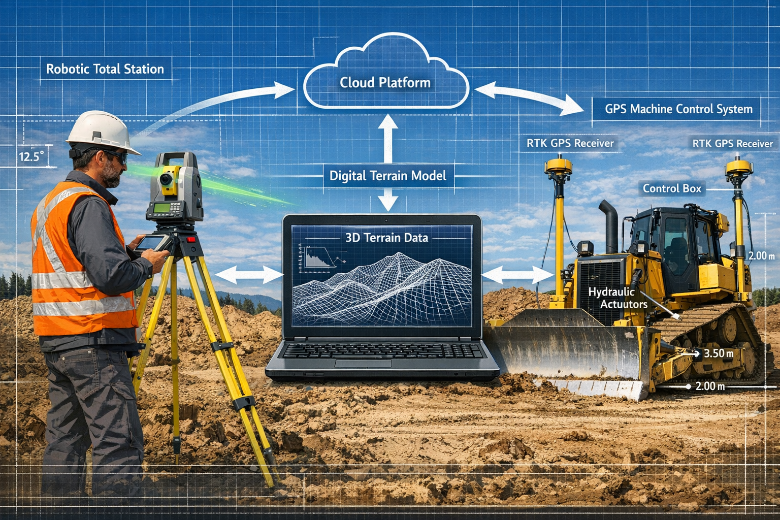
Machine control systems represent the convergence of precision surveying technology and heavy equipment automation. At their core, these systems use real-time positioning data—typically from GPS/GNSS satellites and robotic total stations—to guide earthmoving machinery with centimeter-level accuracy. The operator receives continuous feedback through in-cab displays showing the current position relative to the design surface, enabling precise cut and fill operations without traditional survey stakes[3].
The technology stack includes several critical components:
- GNSS receivers mounted on machines that receive satellite positioning signals
- Robotic total stations providing line-of-sight positioning in areas where satellite coverage is limited
- Hydraulic control systems that automatically adjust blade angles and bucket positions
- Digital terrain models (DTMs) that define the target surface geometry
- In-cab displays showing real-time position, elevation, and cut/fill requirements
- Data management platforms that synchronize design files across equipment and office systems
For property surveying professionals, understanding these systems is essential because surveyors now provide the foundational spatial data that enables machine operation[2]. The accuracy and timeliness of survey deliverables directly impact equipment productivity and project outcomes.
The Evolution from Optional to Essential Technology
Just a few years ago, machine control systems were considered premium technology—an optional upgrade for large-scale projects with substantial budgets. The landscape has changed dramatically. According to industry experts, machine control has undergone a paradigm shift from "optional technology" to essential infrastructure for modern earthmoving projects[2].
This transformation reflects several converging factors:
- Economic pressure: Labor shortages and rising costs make automation financially compelling
- Precision requirements: Modern developments demand tighter tolerances than manual grading can consistently achieve
- Timeline compression: Competitive bidding requires faster project delivery
- Technology accessibility: Systems that once required substantial capital investment now fit within reach of firms of all sizes[2]
Ian Welch, director of engineering at Trimble's Civil Construction Field Systems, notes that autonomy in construction will advance as an "evolution more than a revolution" in 2026, with continued incremental advancements rather than disruptive changes[2]. This measured progression allows surveying firms to adapt their workflows and develop expertise gradually.
How Machine Control Integrates Survey Data with Heavy Equipment
The integration process begins long before equipment arrives on site. Surveyors collect topographic data that captures existing ground conditions, often using advanced surveying technologies including terrestrial laser scanning, drone photogrammetry, and conventional total station surveys.
This as-built data combines with engineering design files to create comprehensive digital terrain models that serve as the operational blueprint for machine control systems[2]. The DTM defines:
- Target elevations across the site
- Slope gradients and transitions
- Drainage patterns and flow directions
- Subgrade and surface layer specifications
- Boundary limits and exclusion zones
Once loaded into the machine control system, these models enable real-time spatial guidance. As the equipment operator moves across the site, the system continuously calculates the difference between the current position and the target design surface. This "cut/fill map" appears on the in-cab display, showing whether the machine needs to remove material (cut) or add material (fill) at any given location.
Advanced systems go beyond simple guidance to provide automated blade control, where hydraulic actuators adjust equipment position without operator input. This semi-autonomous operation dramatically improves consistency and allows operators to focus on machine movement rather than manual adjustments.
The Critical Role of Property Surveying in Machine Control Implementation
Providing Accurate Digital Terrain Models
The foundation of every successful machine control deployment is accurate, comprehensive survey data. Unlike traditional construction where minor survey discrepancies might be corrected during staking, machine control systems amplify data quality issues. An error in the digital terrain model translates directly into equipment operating at incorrect elevations—potentially causing costly rework or safety hazards.
Surveyors must deliver DTMs that meet stringent specifications:
| Parameter | Typical Requirement | Impact if Inadequate |
|---|---|---|
| Horizontal accuracy | ±10-15mm | Incorrect horizontal positioning, boundary violations |
| Vertical accuracy | ±10-15mm | Over-excavation or insufficient cut depth |
| Point density | 5-10m grid (varies by terrain) | Missed terrain features, interpolation errors |
| Format compatibility | LandXML, DXF, proprietary formats | System integration failures, project delays |
| Coordinate system | Project-specific datum and projection | Complete positional mismatch |
The surveying workflow for machine control projects differs significantly from traditional approaches. Rather than establishing control points for subsequent staking, surveyors focus on comprehensive terrain capture and quality-assured data processing. This shift requires different equipment, software expertise, and quality control procedures.
Real-Time Data Delivery and As-Built Verification
As machines become more reliant on automation, site control work, digital terrain models, and as-built verification become even more critical as machines depend on precise spatial information to operate efficiently and safely[2]. This creates new service opportunities for surveying firms willing to adapt their business models.
Modern machine control workflows demand real-time or near-real-time data delivery. Construction schedules no longer accommodate multi-day survey processing cycles. Surveyors must provide:
- Rapid initial surveys capturing existing conditions within 24-48 hours
- Design integration converting engineering plans into machine-readable formats
- Change management updating DTMs as design modifications occur
- Progress monitoring documenting earthwork quantities for payment applications
- Quality verification confirming finished grades meet specifications
The as-built verification component represents a particularly valuable service. Machine control systems generate automatic documentation of where equipment has operated and at what elevations. However, independent surveying verification remains essential for contractual acceptance and quality assurance. This creates ongoing engagement throughout project duration rather than discrete survey events.
Integration with Reality Capture and AI-Enhanced Workflows
Machine control systems increasingly integrate with reality capture technology enhanced by AI, machine learning, and cloud-based platforms, creating comprehensive spatial data ecosystems[2]. This convergence expands the surveyor's role beyond traditional data collection to include:
Automated data processing: AI algorithms can classify point cloud data, identify terrain features, and generate preliminary DTMs with minimal manual intervention. This dramatically accelerates survey processing while maintaining accuracy[1].
Predictive analytics: Machine learning models analyze historical earthwork data to predict productivity rates, identify potential grading challenges, and optimize equipment deployment strategies.
Cloud-based collaboration: Modern platforms enable seamless data sharing between survey teams, equipment operators, project managers, and design engineers. Updates propagate automatically across all connected systems, ensuring everyone works from current information[2].
Integrated quality control: Automated comparison between design models and as-built reality capture identifies discrepancies in real-time, enabling immediate corrections rather than discovering issues during final inspection.
For surveyors navigating the digital transformation of property surveying, these integrated workflows represent both opportunity and challenge. Firms must invest in new software platforms, develop data management protocols, and train staff on emerging technologies. However, those who successfully adapt position themselves as indispensable partners in construction automation.
Implementing Machine Control Systems: Challenges and Solutions for Surveyors
Technical Implementation Challenges
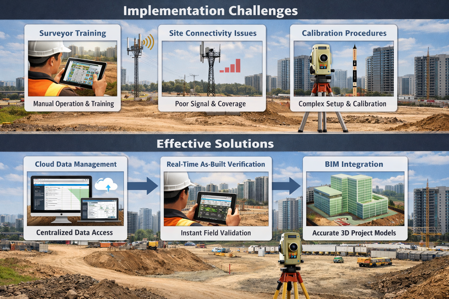
The transition to machine control-enabled surveying workflows presents several technical hurdles that firms must address systematically:
🔧 Equipment and Software Investment
Implementing machine control support requires significant technology upgrades. Surveying firms need:
- GNSS base stations or network RTK subscriptions for real-time positioning
- Robotic total stations capable of machine tracking and guidance
- UAV platforms for rapid site mapping on larger projects
- Processing software that generates machine-compatible DTM formats
- Quality control tools for data validation and verification
While costs have decreased substantially, the initial investment remains substantial for smaller firms. Fortunately, the standardization of technology means that reality capture and digital tools that once required substantial capital investment now fit within reach of firms of all sizes[2].
📡 Site Connectivity and Communication Infrastructure
Machine control systems rely on continuous data connectivity between equipment, base stations, and cloud platforms. Urban construction sites present unique challenges:
- Signal obstruction: Tall buildings and structures can block GNSS satellite visibility
- Network reliability: Cellular data connections may be inconsistent in developing areas
- Interference: Urban electromagnetic environments can disrupt positioning signals
- Multi-system coordination: Multiple machines operating simultaneously require robust communication networks
Solutions include hybrid positioning systems that combine GNSS with robotic total stations, dedicated site WiFi networks, and redundant communication pathways to ensure continuous operation.
📊 Data Format Standardization and Interoperability
Construction projects typically involve multiple software platforms, equipment manufacturers, and stakeholder organizations. Ensuring seamless data exchange requires careful attention to:
- File format compatibility (LandXML, IFC, proprietary formats)
- Coordinate system consistency across all project participants
- Version control and change management protocols
- Quality assurance procedures that verify data integrity throughout the workflow
Many surveying firms establish project-specific data dictionaries that define standards for all digital deliverables, reducing confusion and integration issues.
Workforce Development and Training Requirements
The surveying profession in 2026 faces accelerating digital transformation driven by pressure to deliver faster, more accurate results while navigating workforce shortages[2]. Machine control implementation intensifies these workforce challenges while simultaneously offering solutions.
Skill Development Needs
Traditional surveying education emphasized field measurement techniques, instrument operation, and manual drafting. Machine control workflows require additional competencies:
- 3D modeling proficiency: Creating and editing digital terrain models in CAD and civil design software
- Data processing expertise: Operating point cloud processing software, applying classification algorithms, managing large datasets
- Machine control software knowledge: Understanding equipment-specific platforms and file requirements
- Quality assurance protocols: Implementing systematic validation procedures for digital deliverables
- Communication skills: Collaborating effectively with equipment operators, project managers, and engineers
Many firms implement structured training programs that combine vendor-provided instruction, online learning platforms, and mentorship from experienced staff. The investment in workforce development typically pays dividends through improved efficiency and reduced errors.
Generational Technology Adoption
Interestingly, machine control implementation can help address workforce shortages by making surveying more attractive to younger professionals comfortable with digital technology. The shift from manual staking to digital data management aligns with the preferences and skills of emerging talent.
Return on Investment: Quantifying the Benefits
Understanding the financial case for machine control adoption helps surveying firms justify technology investments and position services effectively to clients.
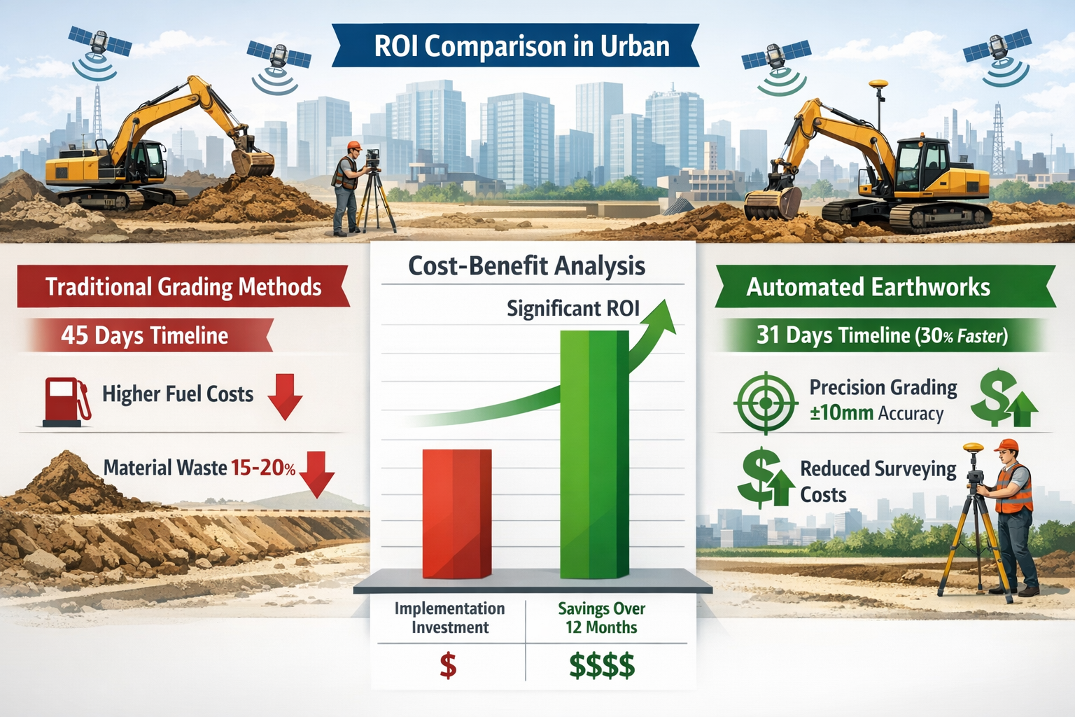
⏱️ Timeline Reduction: The 30% Advantage
The most compelling benefit of machine control systems is dramatic timeline compression. Traditional earthwork projects follow a sequential pattern:
- Survey existing conditions (2-3 days)
- Process data and create staking plans (1-2 days)
- Field stake the site (2-5 days depending on size)
- Equipment operates to stakes (variable duration)
- Survey verification and re-staking (1-2 days)
- Repeat steps 4-5 until complete
Machine control eliminates steps 3 and 5 entirely, enabling continuous operation without waiting for survey crews. Projects that traditionally required 45 days of earthwork can be completed in approximately 31 days—a 30% timeline reduction that translates directly to cost savings through reduced equipment rental, labor expenses, and project overhead.
💰 Cost Savings Beyond Speed
Timeline reduction represents only one component of machine control ROI. Additional financial benefits include:
- Reduced surveying labor: Elimination of repetitive staking reduces field crew requirements by 40-60%
- Material waste reduction: Precision grading minimizes over-excavation and excess material handling, reducing disposal costs by 15-25%
- Fuel efficiency: Optimized equipment operation and reduced passes decrease fuel consumption by 10-15%
- Rework elimination: Achieving correct grades on the first pass eliminates costly corrections
- Predictive maintenance: Infrastructure asset management supported by spatial data can reduce maintenance costs by as much as 40% through shifting from reactive to predictive approaches[2]
📈 Competitive Positioning and Market Differentiation
For surveying firms, offering machine control support services provides significant competitive advantages:
- Higher-value engagements: Machine control projects command premium fees compared to traditional surveying
- Extended project involvement: Ongoing data management and verification create recurring revenue throughout construction
- Client relationship strengthening: Becoming integral to construction automation deepens client partnerships
- Market differentiation: Relatively few surveying firms offer comprehensive machine control support, creating blue ocean opportunities
The combination of internal efficiency gains and enhanced service offerings typically generates positive ROI within 12-18 months for firms that commit to comprehensive implementation.
Machine Control Systems in Urban Development Projects
Unique Challenges of Urban Construction Sites
Urban development projects present distinct challenges that make machine control systems particularly valuable while simultaneously complicating implementation:
Space Constraints and Precision Requirements
Urban sites typically feature:
- Limited working area: Tight lot boundaries with minimal tolerance for error
- Adjacent structures: Existing buildings requiring careful excavation to avoid damage
- Underground utilities: Dense networks of pipes, cables, and infrastructure
- Access restrictions: Narrow entry points limiting equipment size and maneuverability
Machine control systems address these challenges through precision guidance that enables operators to work confidently within tight tolerances. The ability to grade within 10-15mm of design specifications reduces the risk of boundary violations or utility strikes.
GNSS Signal Challenges in Urban Environments
Tall buildings create "urban canyons" that obstruct satellite visibility, degrading GNSS positioning accuracy. Successful urban machine control implementation requires hybrid positioning strategies:
- Robotic total station integration: Line-of-sight positioning supplements GNSS in obstructed areas
- Multi-constellation GNSS receivers: Accessing GPS, GLONASS, Galileo, and BeiDou satellites increases available signals
- Network RTK services: Commercial correction services improve accuracy and reliability
- Inertial measurement units: IMU sensors maintain positioning during brief signal losses
Surveyors must conduct site reconnaissance before machine control deployment to identify signal challenges and design appropriate positioning strategies.
Case Applications: Residential and Commercial Developments
High-Density Residential Projects
Urban residential developments benefit significantly from machine control automation:
- Foundation excavation: Precise basement and foundation grading reduces concrete waste and ensures proper drainage
- Underground parking structures: Multi-level excavations with complex geometry require exact depth control
- Site grading and drainage: Achieving specified slopes for stormwater management prevents costly water intrusion issues
- Utility trenching: Automated trench excavation maintains consistent depth and slope for sewer and water lines
A typical urban residential project might include 50-100 individual foundation excavations, each requiring precise depth and level control. Machine control systems enable continuous operation without waiting for surveyors to stake each location, compressing schedules significantly.
Commercial and Mixed-Use Developments
Large commercial projects amplify the benefits of machine control through scale:
- Site preparation: Grading large parking areas and building pads to exact specifications
- Detention basin construction: Creating stormwater management features with precise volume calculations
- Roadway and infrastructure: Building access roads, utilities, and site improvements to municipal standards
- Phased construction coordination: Managing multiple construction phases with integrated digital models
For commercial projects, the as-built documentation generated by machine control systems provides valuable data for commercial property surveys and ongoing facility management.
Integration with Building Information Modeling (BIM)
The convergence of machine control systems with Building Information Modeling creates powerful opportunities for integrated project delivery:
Site-to-Structure Data Continuity
BIM workflows traditionally focused on building design and construction, treating site work as a separate process. Machine control integration enables seamless data flow from site surveying through earthwork to structural construction:
- Survey data populates the BIM site model with existing conditions
- Civil design elements (grading, utilities, paving) integrate with architectural and structural models
- Machine control systems execute earthwork based on BIM-derived DTMs
- As-built survey data updates the BIM model, creating a digital twin of constructed conditions
- Facility management systems leverage the comprehensive BIM model for ongoing operations
This integrated approach reduces errors, eliminates redundant data entry, and creates a comprehensive digital record of the project.
Clash Detection and Constructability Analysis
BIM-integrated machine control workflows enable proactive problem identification:
- Utility conflicts: Identifying clashes between proposed grading and existing underground infrastructure before excavation begins
- Drainage verification: Analyzing surface water flow patterns to ensure proper site drainage
- Access analysis: Confirming equipment can reach all work areas given site constraints
- Quantity validation: Comparing earthwork volumes across survey, design, and as-built models to identify discrepancies
For surveyors, BIM integration expands service offerings beyond traditional data collection to include constructability consulting and quality assurance coordination.
Advanced Machine Control Technologies Shaping 2026 Construction
Autonomous and Semi-Autonomous Equipment Operation
The evolution toward fully autonomous construction equipment continues steadily in 2026, with machine control systems serving as foundational technologies that enable smarter machines and workflows across earthmoving and civil construction projects[2].
Current State of Construction Autonomy
Today's machine control systems operate primarily in semi-autonomous mode, where:
- Operators control horizontal movement and equipment travel
- Automated systems manage vertical positioning (blade height, bucket angle)
- Continuous feedback guides operators toward optimal efficiency
- Safety systems prevent operation outside defined boundaries
Fully autonomous operation—where equipment operates without human intervention—remains limited to specific applications such as compaction and repetitive grading tasks. However, the technology foundation exists, and incremental advancement continues.
The Evolution Approach to Full Autonomy
Industry experts emphasize that autonomy in construction will advance as an "evolution more than a revolution"[2]. This measured progression allows:
- Gradual workforce adaptation: Operators develop skills progressively rather than facing disruptive change
- Reliability validation: Each incremental advancement undergoes extensive field testing before widespread adoption
- Regulatory development: Safety standards and operational regulations evolve alongside technology
- Economic justification: Each capability increment must demonstrate clear ROI to drive adoption
For surveyors, this evolutionary path means sustained demand for precision spatial data as increasingly sophisticated machines require correspondingly accurate positioning information.
Underground and Specialized Applications
Machine control technology extends beyond surface earthwork to specialized applications that present unique surveying challenges.
Underground Construction and Tunneling
The specialized webinar hosted by Trimble and VMT on January 27, 2026, focused on "groundbreaking advancements and innovative solutions in underground technology for machine control, monitoring, and surveying"[4], highlighting active innovation in this sector.
Underground machine control applications include:
- Tunnel boring machines: Automated guidance systems maintaining precise alignment and grade
- Underground utility installation: Horizontal directional drilling with real-time positioning
- Mining operations: Automated excavation and material handling in confined spaces
- Foundation drilling: Precision pile and caisson placement for deep foundations
These applications require specialized surveying techniques including:
- Gyroscopic positioning systems for GNSS-denied environments
- Laser-based guidance for tunnel alignment
- Inertial navigation for continuous positioning
- Distributed monitoring networks for deformation tracking
Surveyors developing expertise in underground applications access high-value niche markets with limited competition.
Specialized Earthwork Applications
Beyond conventional grading, machine control enables precision in specialized operations:
- Slope construction: Building embankments and cuts with exact slope angles for stability
- Trench excavation: Maintaining consistent depth and width for utility installation
- Precision agriculture: Land leveling for irrigation efficiency (crossover application)
- Environmental remediation: Selective excavation of contaminated soils to precise depths
Each application requires customized survey workflows and specialized knowledge, creating opportunities for surveying firms to develop vertical market expertise.
Integration with Drones and Reality Capture Platforms
The convergence of AI, cloud-based collaboration platforms, and interoperable hardware and software fundamentally reshapes how surveying data is captured and processed for machine control applications[2].
UAV-Based Site Mapping
Unmanned aerial vehicles have become standard tools for machine control site surveying:
Benefits of drone-based data collection:
- ✅ Rapid coverage: Survey 50+ acres in a single flight session
- ✅ Comprehensive documentation: Capture entire site conditions without accessibility limitations
- ✅ Frequent updates: Enable weekly or even daily progress monitoring
- ✅ Safety improvement: Eliminate surveyor exposure to active construction zones
- ✅ Cost efficiency: Reduce field time by 60-80% compared to conventional methods
Workflow integration:
- Automated flight planning based on project boundaries
- Photogrammetric or LiDAR data capture
- Cloud-based processing generating point clouds and orthomosaics
- AI-assisted classification and DTM extraction
- Direct export to machine control formats
- Automated change detection comparing successive surveys
Terrestrial Laser Scanning for Complex Sites
Urban construction sites with significant vertical elements benefit from terrestrial laser scanning:
- Existing building documentation: Capturing adjacent structures for protection monitoring
- Complex terrain capture: Recording irregular surfaces and features
- As-built verification: Documenting completed work with millimeter-level detail
- Utility mapping: Identifying visible infrastructure for conflict analysis
The integration of drone and terrestrial scanning creates comprehensive 3D site models that support machine control while providing valuable documentation for construction surveys and project records.
Best Practices for Surveyors Supporting Machine Control Projects
Pre-Project Planning and Client Consultation
Successful machine control projects begin with comprehensive planning that establishes clear expectations and workflows:
Initial Client Engagement
When clients inquire about machine control support, surveyors should:
- Assess project suitability: Not all projects benefit equally from machine control; evaluate site size, complexity, and timeline
- Identify stakeholders: Determine who will use the data (equipment operators, contractors, engineers)
- Establish deliverable specifications: Define required accuracy, formats, coordinate systems, and delivery schedules
- Clarify scope boundaries: Distinguish between initial survey, ongoing updates, and as-built verification
- Discuss technology requirements: Ensure client equipment compatibility with surveying deliverables
Project Control Network Design
Machine control projects require robust control networks that support both initial surveying and ongoing construction layout:
- Permanent control monuments: Stable, protected points that survive construction activities
- Redundant observations: Multiple control points ensuring work can continue if individual monuments are disturbed
- GNSS base station locations: Positioning base stations for optimal satellite visibility and site coverage
- Coordinate system definition: Establishing project datum that minimizes distortion across the site
- Quality documentation: Providing comprehensive control network reports for all project participants
Investing time in control network design prevents costly delays and positioning issues during construction.
Quality Assurance Protocols for Digital Deliverables
The accuracy and reliability of digital terrain models directly impact construction outcomes, making quality assurance essential:
Multi-Stage Validation Process
Implement systematic QA procedures:
- Field data validation: Real-time quality checks during survey data collection
- Processing verification: Statistical analysis of point cloud accuracy and completeness
- Model validation: Comparing DTM surfaces against source data to identify interpolation errors
- Format testing: Loading deliverables into machine control software to verify compatibility
- Independent checking: Having a second surveyor review critical deliverables
- Client acceptance: Obtaining formal approval before construction begins
Common Error Sources and Prevention
| Error Type | Impact | Prevention Strategy |
|---|---|---|
| Coordinate system mismatch | Complete positional failure | Standardized project setup procedures |
| Insufficient point density | Missed terrain features | Automated density analysis during collection |
| Processing artifacts | Incorrect surface elevations | Visual inspection of contours and profiles |
| Format incompatibility | System integration failure | Test files with actual equipment before delivery |
| Version control issues | Working from outdated data | Cloud-based file management with version tracking |
Documentation Standards
Comprehensive documentation supports quality assurance and provides liability protection:
- Metadata records: Documenting collection dates, equipment used, processing methods, accuracy estimates
- Deliverable registers: Tracking all files provided to clients with version numbers and dates
- Change logs: Recording design modifications and DTM updates throughout the project
- Validation reports: Providing statistical summaries of accuracy and completeness
- As-built certifications: Formal documentation that finished grades meet specifications
Ongoing Communication and Project Coordination
Machine control projects require continuous collaboration rather than discrete survey deliverables:
Establishing Communication Protocols
Define clear communication channels:
- Primary contacts: Identifying key personnel for each organization (surveyor, equipment operator, project manager, engineer)
- Update frequency: Establishing schedules for progress meetings and data deliveries
- Issue escalation: Creating procedures for addressing problems quickly
- Change management: Defining how design modifications are communicated and implemented
- Emergency contacts: Ensuring 24/7 availability for critical issues
Progress Monitoring and Reporting
Regular progress documentation serves multiple purposes:
- Payment applications: Providing earthwork quantity calculations for contractor billing
- Schedule tracking: Documenting completion percentages and identifying delays
- Quality verification: Confirming work meets specifications before proceeding to next phases
- Change order support: Documenting conditions that differ from original design assumptions
- Stakeholder updates: Keeping project owners and managers informed of construction status
Many surveying firms provide automated progress dashboards using cloud platforms that display current conditions, completion percentages, and quality metrics in real-time.
The Future of Machine Control in Property Surveying
Emerging Technologies and Trends
The machine control landscape continues evolving rapidly, with several technologies poised to reshape surveying workflows:
Artificial Intelligence and Machine Learning Integration
AI technologies are transforming machine control applications:
- Automated feature extraction: AI algorithms identifying terrain features, utilities, and site conditions from point cloud data without manual classification[1]
- Predictive earthwork planning: Machine learning models analyzing site conditions to optimize equipment deployment and grading sequences
- Quality prediction: AI systems identifying areas likely to require rework based on historical patterns
- Anomaly detection: Automated identification of survey data outliers and potential errors
These capabilities reduce manual processing time while improving consistency and accuracy.
5G and Edge Computing
Next-generation connectivity enables new machine control capabilities:
- Real-time collaboration: Multiple stakeholders viewing and interacting with site data simultaneously
- Instant data synchronization: Eliminating delays between survey collection and machine availability
- Augmented reality guidance: Operators viewing design overlays through AR headsets or windshield displays
- Distributed processing: Edge computing enabling complex calculations on-site without cloud latency
Digital Twin Integration
Comprehensive digital twins that span project lifecycle are becoming standard:
- Pre-construction simulation: Testing grading sequences and equipment deployment virtually before mobilization
- Real-time construction monitoring: Comparing actual progress against planned schedules and identifying variances
- Post-construction asset management: Leveraging as-built data for facility operations and maintenance
- Predictive analytics: Using historical project data to improve future planning and estimation
For surveyors, digital twins create sustained engagement throughout the property lifecycle, from initial site analysis through decades of facility management.
Expanding Market Opportunities for Surveying Firms
Machine control adoption creates diverse service opportunities:
Specialized Service Offerings
- Machine control consulting: Helping contractors evaluate and implement automation technologies
- Operator training support: Providing on-site guidance during system deployment
- Data management services: Ongoing DTM updates and version control throughout construction
- Quality assurance coordination: Independent verification of automated earthwork
- Technology integration: Connecting machine control systems with BIM platforms and project management tools
Vertical Market Specialization
Developing expertise in specific construction sectors:
- Residential development: High-volume foundation and site grading projects
- Commercial construction: Large-scale site preparation and infrastructure
- Infrastructure projects: Roads, utilities, and municipal improvements
- Environmental remediation: Precision excavation and site restoration
- Mining and aggregates: Specialized extraction and processing operations
Geographic Expansion
Machine control technology enables surveying firms to serve larger geographic areas efficiently:
- Remote data collection using drones and autonomous systems
- Cloud-based deliverable distribution eliminating physical travel
- Virtual project coordination reducing on-site presence requirements
- Scalable workflows supporting multiple simultaneous projects
Preparing Your Surveying Practice for Machine Control Demand
Firms seeking to capitalize on machine control opportunities should consider strategic investments:
Technology Infrastructure
- Hardware: GNSS receivers, robotic total stations, UAV platforms, processing workstations
- Software: Point cloud processing, civil design, machine control file generation, quality control tools
- Connectivity: High-speed internet, cloud storage, collaboration platforms
- Backup systems: Redundant equipment ensuring continuous service capability
Workforce Development
- Formal training: Vendor certification programs for equipment and software
- Continuing education: Regular updates on emerging technologies and methods
- Cross-training: Developing multiple staff members with machine control expertise
- Recruitment: Attracting talent with digital technology skills and construction knowledge
Business Development
- Marketing materials: Case studies, technical capabilities documentation, client testimonials
- Industry networking: Participating in construction technology conferences and associations
- Strategic partnerships: Collaborating with equipment dealers, contractors, and technology providers
- Pilot projects: Demonstrating capabilities through discounted initial engagements
The firms that invest strategically in machine control capabilities position themselves for sustained growth as automation becomes standard across construction projects.
Conclusion: Embracing the Machine Control Revolution in Property Surveying
Machine Control Systems in Property Surveying: Automating Earthworks for 2026 Construction Projects represent far more than incremental technological advancement—they constitute a fundamental transformation in how construction projects are planned, executed, and documented. The ability to reduce project timelines by 30% while simultaneously improving accuracy, reducing waste, and enhancing safety creates compelling value that's driving rapid adoption across urban development projects.
For property surveyors, this transformation presents both challenge and opportunity. The traditional role of providing discrete survey deliverables is evolving toward continuous data management and quality assurance throughout construction. Firms that adapt their service models, invest in appropriate technology, and develop machine control expertise position themselves as indispensable partners in construction automation.
The journey from optional technology to essential infrastructure is complete—machine control systems are now foundational to competitive construction operations[2]. The surveying profession must embrace this reality and develop the capabilities necessary to support automated earthwork effectively.
Actionable Next Steps for Surveying Professionals
For Individual Surveyors:
- Develop digital modeling skills through CAD and civil design software training
- Gain hands-on experience with GNSS, robotic total stations, and UAV platforms
- Learn machine control file formats and generation procedures
- Build construction knowledge understanding earthwork operations and equipment capabilities
- Network with contractors using machine control to understand their needs and challenges
For Surveying Firm Owners:
- Assess current capabilities identifying gaps in technology, skills, and workflows
- Develop implementation roadmap prioritizing investments based on market demand and ROI
- Establish strategic partnerships with equipment dealers, technology vendors, and contractors
- Launch pilot projects demonstrating machine control support capabilities to potential clients
- Invest in workforce development ensuring staff have skills necessary for digital workflows
- Market new capabilities updating business development materials and client communications
For Construction Project Stakeholders:
- Evaluate project suitability determining which projects benefit most from machine control
- Engage surveying partners early involving them in pre-construction planning and design review
- Establish clear deliverable specifications defining accuracy requirements, formats, and schedules
- Implement robust communication protocols ensuring continuous coordination throughout construction
- Leverage as-built data using survey documentation for facility management and future projects
The integration of machine control systems with property surveying workflows represents one of the most significant advancements in construction technology. Those who embrace this transformation—investing in capabilities, developing expertise, and adapting business models—will thrive in the increasingly automated construction landscape of 2026 and beyond.
The future of earthwork is automated, precise, and data-driven. The future of surveying is providing the foundational spatial information that makes this automation possible. The convergence of these futures creates unprecedented opportunity for professionals ready to lead the industry forward.
References
[1] Ai Driven Precision In Property Surveying How Artificial Intelligence Is Revolutionizing Workflows In 2026 – https://nottinghillsurveyors.com/blog/ai-driven-precision-in-property-surveying-how-artificial-intelligence-is-revolutionizing-workflows-in-2026
[2] Doubling Down On Digital – https://amerisurv.com/2026/02/01/doubling-down-on-digital/
[3] A Guide To Leveraging Advanced Surveying And Engineering Technologies For Small To Mid Size Property Development – https://ess-inc.com/a-guide-to-leveraging-advanced-surveying-and-engineering-technologies-for-small-to-mid-size-property-development/
[4] Underground Technology For Machine Control And Surveying Advancements And Innovation – https://geospatial.trimble.com/en/resources/webinar/underground-technology-for-machine-control-and-surveying-advancements-and-innovation
[5] Doubling Down On Digital Top 6 Surveying Trends Shaping 2026 From Trimble Experts – https://nottinghillsurveyors.com/blog/doubling-down-on-digital-top-6-surveying-trends-shaping-2026-from-trimble-experts