
The construction and surveying industries stand at a pivotal crossroads in 2026. Project teams no longer accept isolated data silos, static deliverables, or incompatible file formats that slow collaboration and inflate costs. Instead, Interoperable Data Environments: Unifying Survey Platforms for Seamless 2026 Project Collaboration has emerged as the defining requirement for modern surveying practices. This transformation represents far more than a technological upgrade—it fundamentally reshapes how surveyors contribute to project success, positioning spatial data professionals as essential partners in dynamic, connected workflows rather than isolated service providers.
As digital transformation accelerates across the construction sector, surveying firms face mounting pressure to deliver faster, more accurate results while navigating workforce shortages and rapidly evolving client expectations.[1] The firms that thrive in this environment are those that embrace interoperability as a competitive advantage, breaking down barriers between survey software, Building Information Modeling (BIM) platforms, and client portals to enable instant data sharing across multidisciplinary teams.
Key Takeaways
- 🔗 Interoperable data environments enable surveyors to contribute to dynamic, shared platforms where spatial information integrates seamlessly with broader project data, transforming static deliverables into real-time collaboration tools
- 📊 Client expectations have fundamentally shifted—modern projects demand survey data optimized for 3D visualization, BIM integration, and seamless digital handoffs that support long-term asset management strategies
- 🚀 Standardized protocols and APIs are becoming procurement requirements across industries, with organizations prioritizing exchange-ready architectures that reduce friction in data handoffs and expand potential client bases
- 💡 Future-proof workflows require surveyors to master interoperability protocols, understand multiple software ecosystems, and deliver data formatted for integration within diverse technology stacks
- ⚡ Competitive advantage now belongs to firms that position themselves as essential partners in collaborative workflows by delivering survey data that unlocks value across the entire project lifecycle
Understanding Interoperable Data Environments in Modern Surveying
What Are Interoperable Data Environments?
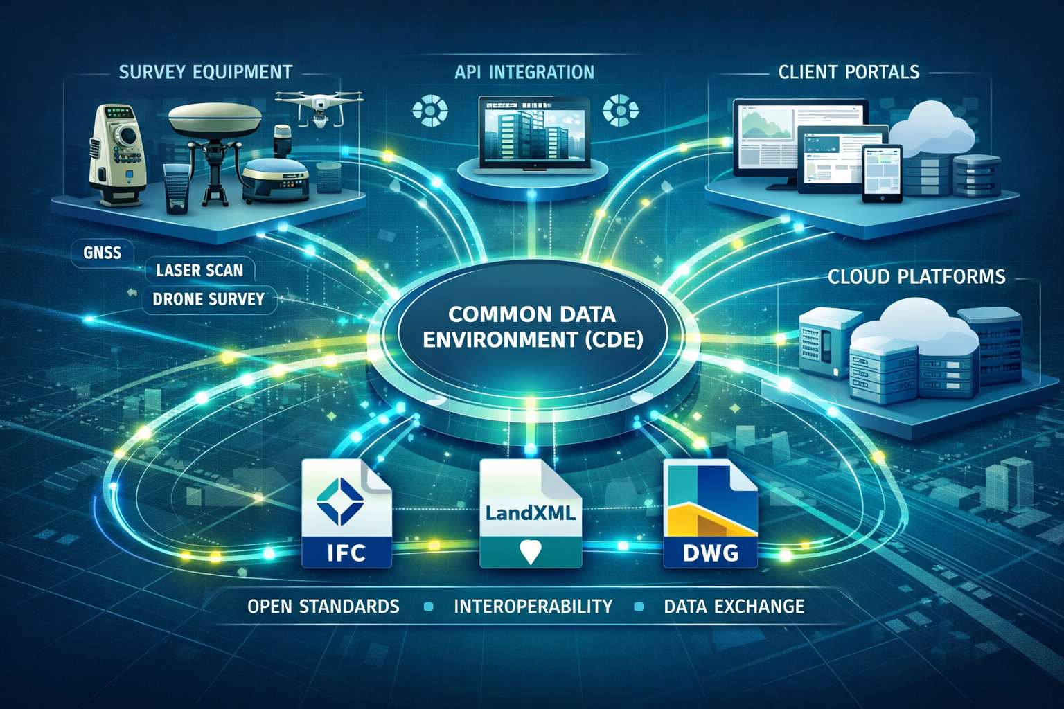
Interoperable Data Environments represent a fundamental shift from traditional surveying deliverables to integrated digital ecosystems where spatial data flows seamlessly across multiple platforms, stakeholders, and project phases. Rather than producing isolated static plans or point clouds that exist in proprietary formats, surveyors in 2026 contribute to dynamic, shared environments where their work informs real-time decision-making across project teams.[1]
These environments are built on standardized data exchange protocols, open file formats, and Application Programming Interfaces (APIs) that enable different software systems to communicate without manual data conversion or quality loss. When a surveyor captures topographic data using modern equipment, that information can automatically populate BIM models, update client dashboards, inform design decisions, and feed into construction management platforms—all without requiring separate exports, conversions, or manual data entry.
The Evolution from Static to Dynamic Data Sharing
The surveying profession has undergone a remarkable transformation over the past decade. Traditional workflows involved:
- 📋 Capturing field measurements using total stations or GPS equipment
- 💾 Processing data in proprietary desktop software
- 📄 Producing static CAD drawings or PDF reports
- 📧 Delivering files via email or file transfer
- ⏳ Waiting for client feedback through disconnected communication channels
This linear, disconnected approach created significant inefficiencies. Each handoff introduced potential for errors, version control issues, and delays. Clients received data that might not integrate with their existing systems, requiring costly manual rework or limiting the value they could extract from survey deliverables.
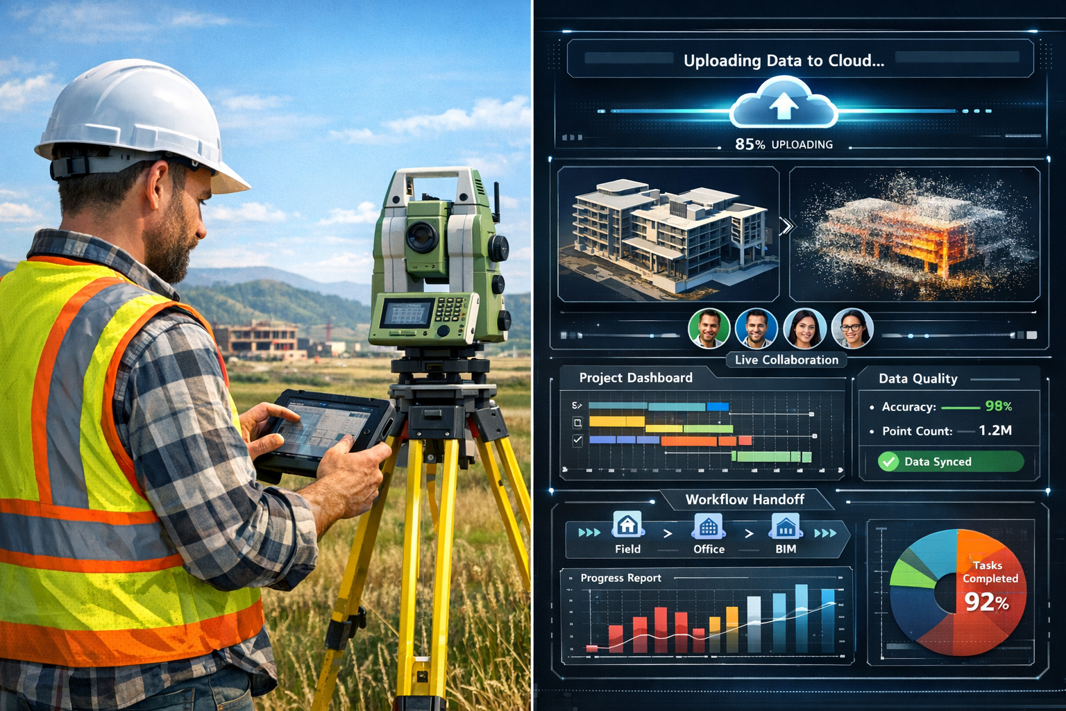
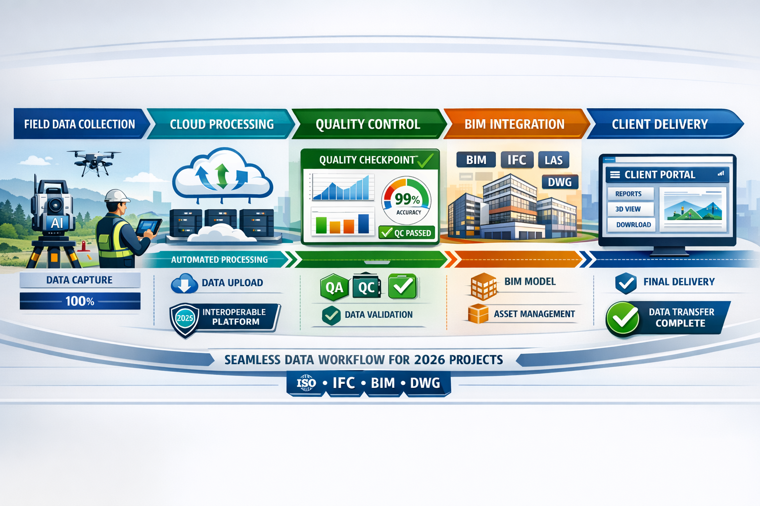
Modern interoperable workflows have transformed this process:
- ☁️ Cloud-based data capture enables real-time upload from field equipment
- 🔄 Automated processing applies AI-enhanced algorithms in cloud platforms
- 🌐 Instant availability makes data accessible to authorized stakeholders immediately
- 🔗 Automatic integration populates connected systems without manual intervention
- 💬 Collaborative feedback happens within the shared environment itself
This evolution reflects broader trends identified by industry experts, who note that data sharing across diverse teams and technology platforms has become essential for modern projects, with surveying professionals working at the intersection of multiple stakeholder groups using different software systems and workflows.[1]
Common Data Environments (CDEs) as the Foundation
Common Data Environments serve as the technological foundation for interoperable surveying workflows. As the construction industry evolves into a data-driven sector, CDEs are taking hold as both a delivery platform and collaboration tool that fundamentally changes how spatial information integrates with broader project data.[1]
A well-implemented CDE provides:
| CDE Feature | Benefit to Surveying Workflows |
|---|---|
| Centralized data repository | Single source of truth eliminates version control issues |
| Role-based access control | Stakeholders see relevant data without security risks |
| Automated workflows | Survey data triggers downstream processes automatically |
| Audit trails | Complete tracking of data changes and access |
| Standards compliance | Built-in validation ensures deliverables meet specifications |
| Integration APIs | Seamless connection to design, construction, and management tools |
For surveying firms, understanding and working effectively within CDEs has shifted from optional to essential. Professional surveyors who master these platforms position themselves as strategic partners rather than transactional service providers.
The Business Case for Interoperable Data Environments: Unifying Survey Platforms for Seamless 2026 Project Collaboration
Rising Client Expectations Drive Adoption
Client expectations have fundamentally transformed in recent years. As systems connect more easily, clients increasingly expect survey data that integrates seamlessly within their existing technology stacks, with firms no longer needing to worry whether deliverables will function within client infrastructure.[1]
This shift creates both challenges and opportunities for surveying practices. Firms that continue delivering traditional static outputs find themselves at a competitive disadvantage, while those that embrace interoperability discover new revenue streams and stronger client relationships.
Key client demands in 2026 include:
- 🎯 Format flexibility: Data delivered in multiple formats optimized for different uses (BIM, GIS, visualization, analysis)
- ⚡ Speed: Near-instantaneous availability of survey data for time-sensitive decisions
- 📊 Integration readiness: Deliverables that populate client systems without manual intervention
- 🔍 Transparency: Real-time visibility into survey progress and preliminary results
- 📈 Value extension: Survey data that supports asset management beyond initial project completion
Firms delivering survey data optimized for 3D visualization and Building Information Modeling (BIM) integration position themselves as essential partners in collaborative workflows rather than simply vendors of measurement services.[1] This positioning translates directly to competitive advantages in procurement processes and higher-value project opportunities.
Reduced Friction Expands Market Opportunities
Improved interoperability fundamentally expands the addressable market for surveying firms. When workflows and integrations become standardized across platforms, reduced friction in data handoffs expands the potential client base, as geographic and technical barriers diminish.[1]
Consider these market expansion scenarios:
Geographic expansion: A surveying firm in West London can seamlessly serve clients across the UK or internationally when deliverables integrate with cloud-based CDEs accessible from anywhere. Physical distance becomes less relevant when data flows through standardized digital channels.
Sector diversification: Firms traditionally focused on residential work can more easily enter commercial markets when their data integrates with enterprise-grade project management platforms used by commercial developers and contractors.
Service expansion: Different types of surveyors can collaborate more effectively on complex projects, offering comprehensive service packages that would be logistically challenging with disconnected workflows. A firm might combine boundary surveys, drainage surveys, and building surveys into integrated deliverables that provide exceptional client value.
Interoperability as Procurement Requirement
The shift toward interoperability requirements in procurement processes represents one of the most significant business drivers for adoption. In parallel sectors, this trend has already reached maturity—for example, in healthcare IT, 92% of surveyed hospital systems report that FHIR/API interoperability is a top-three procurement requirement for new platform decisions.[4]
The construction and surveying sectors are following similar trajectories. Procurement increasingly hinges on the ability to support cross-organization exchange and standards-based APIs, with organizations prioritizing exchange-ready architectures and interoperability layers for operational viability.[4]
Procurement evaluation criteria increasingly include:
- ✅ Demonstrated experience delivering to Common Data Environments
- ✅ Capability to provide data in multiple standardized formats (IFC, LandXML, etc.)
- ✅ Integration with client-specified software platforms
- ✅ Cloud-based collaboration capabilities
- ✅ Real-time data sharing and progress visibility
- ✅ Quality assurance processes aligned with digital workflows
Surveying firms that cannot demonstrate these capabilities find themselves excluded from consideration for major projects, regardless of their technical competence in traditional surveying skills. The message is clear: interoperability is no longer a differentiator—it's a baseline requirement for market participation.
Implementing Interoperable Data Environments: Unifying Survey Platforms for Seamless 2026 Project Collaboration
Breaking Down Technology Silos
Successful implementation of interoperable data environments requires systematically breaking down the technology silos that have traditionally separated survey software, design platforms, and project management tools. This process involves both technical integration and organizational change management.
Survey Equipment and Software Integration
Modern survey equipment increasingly includes built-in connectivity features that enable direct integration with cloud platforms. Total stations, GPS receivers, laser scanners, and drone systems now commonly feature:
- 📡 Cellular or Wi-Fi connectivity for real-time data upload
- 🔌 API endpoints that enable third-party software integration
- 📱 Mobile apps that connect field operations to office systems
- ☁️ Cloud processing capabilities that automate post-processing workflows
The key is selecting equipment and software that supports open standards rather than proprietary formats. When evaluating technology investments, surveying firms should prioritize:
- Open file format support: Can the system export to industry-standard formats (LAS, E57, IFC, LandXML, DWG)?
- API availability: Does the vendor provide documented APIs for custom integrations?
- Cloud compatibility: Can data flow directly to cloud-based CDEs without manual intervention?
- Multi-platform support: Does the software work across Windows, macOS, mobile, and web platforms?
BIM Integration Protocols
Building Information Modeling represents one of the most important integration points for modern surveying workflows. Survey data feeds BIM processes at multiple stages:
- 🏗️ Pre-construction: Existing conditions modeling and site analysis
- 📐 Design: Topographic context for architectural and engineering design
- 🚧 Construction: As-built verification and quality control
- 🏢 Operations: Facility management and asset information models
Effective BIM integration requires understanding both technical formats and collaborative workflows. The Industry Foundation Classes (IFC) format serves as the primary open standard for BIM data exchange, enabling survey data to populate BIM models regardless of the authoring software used.
Best practices for BIM integration include:
- Converting point cloud data to intelligent BIM objects where appropriate
- Maintaining coordinate system consistency across survey and design data
- Establishing clear Level of Detail (LOD) specifications for survey deliverables
- Participating in BIM coordination meetings to understand data requirements
- Delivering survey data with appropriate metadata for BIM workflows
Understanding what surveyors look for and how that information translates to BIM requirements helps bridge the gap between traditional surveying and modern integrated workflows.
Client Portal and Dashboard Integration
Beyond technical file formats, modern interoperability extends to user-facing interfaces where clients access and interact with survey data. Client portals and dashboards represent the "last mile" of interoperability—where technical data becomes actionable business intelligence.
Effective client portal integration enables:
- 📊 Visual progress tracking with maps showing completed survey areas
- 📈 Quality metrics dashboards displaying accuracy statistics and validation results
- 🗂️ Document management with automatic organization of deliverables by type and date
- 🔔 Automated notifications when new data becomes available or milestones are reached
- 💬 Integrated communication allowing questions and feedback within the data context
Many surveying firms develop custom portal solutions, while others integrate with established platforms used by their client base. The choice depends on client preferences, project scale, and technical capabilities.
Establishing Interoperability Protocols and Standards
Technical integration alone doesn't create true interoperability—standardized protocols and workflows are equally essential. Surveying firms should establish clear protocols covering:
Data Exchange Standards
File format specifications:
- Primary format: IFC for BIM integration, LAS/E57 for point clouds, LandXML for civil engineering
- Secondary formats: DWG, PDF, shapefile for specific use cases
- Naming conventions: Standardized file naming that enables automated processing
- Metadata requirements: Embedded coordinate systems, accuracy specifications, capture dates
Quality Assurance Workflows
Validation checkpoints:
- Field data validation before upload to shared environments
- Automated quality checks using cloud processing algorithms
- Peer review protocols for critical deliverables
- Client approval workflows integrated with CDE platforms
Communication Protocols
Stakeholder engagement:
- Regular update schedules aligned with project milestones
- Escalation procedures for issues requiring immediate attention
- Documentation standards for technical decisions affecting data integration
- Training provisions for clients unfamiliar with interoperable workflows
Technology Vendor Partnerships
Construction technology vendors are accelerating efforts to enhance interoperability by building workflows and integrations between construction technology ecosystems, providing more opportunities for construction teams to share project data regardless of software deployed.[1]
Surveying firms should actively engage with their technology vendors to:
- 🤝 Request integration features that support client-specific workflows
- 📚 Participate in beta programs for new interoperability capabilities
- 🎓 Access training resources on emerging standards and protocols
- 🔧 Provide feedback on integration challenges encountered in real projects
- 🌐 Join user communities where best practices are shared
The vendor landscape is rapidly evolving, with major platforms increasingly offering pre-built integrations, API marketplaces, and partnership ecosystems that reduce the technical burden of achieving interoperability.
Future-Proofing Surveying Workflows for 2026 and Beyond
Embracing AI-Enhanced Interoperability
The convergence of artificial intelligence (AI), cloud-based collaboration platforms, and interoperable hardware and software is fundamentally reshaping how spatial data is captured, processed, and shared.[1] AI enhances interoperability in several critical ways:
Automated data classification: AI algorithms automatically classify point cloud data into meaningful categories (ground, vegetation, buildings, utilities), creating structured datasets that integrate more effectively with downstream applications.
Quality validation: Machine learning models detect anomalies, gaps, and accuracy issues in survey data before it enters shared environments, maintaining data integrity across integrated workflows.
Format translation: AI-powered conversion tools intelligently translate between different data formats while preserving semantic meaning and geometric accuracy, reducing manual intervention in multi-platform workflows.
Intelligent routing: Smart systems automatically route survey data to appropriate stakeholders and systems based on project context, data type, and workflow requirements.
Surveying firms that incorporate AI capabilities into their workflows gain significant efficiency advantages while improving the reliability of their contributions to interoperable data environments.
Continuous Learning and Skill Development
The rapid evolution of interoperability standards and platforms requires ongoing professional development. Surveying professionals must expand their skill sets beyond traditional measurement techniques to include:
- 💻 Software proficiency: Understanding multiple platforms rather than deep expertise in a single tool
- 🔗 Integration knowledge: Basic understanding of APIs, data formats, and system architectures
- 📋 Project management: Coordinating deliverables within complex multi-stakeholder workflows
- 💬 Communication skills: Translating technical survey concepts for diverse audiences
- 🎯 Business acumen: Understanding how survey data creates value across project lifecycles
Professional organizations and technology vendors offer training programs specifically focused on interoperability competencies. Chartered surveyors who invest in these capabilities position themselves for leadership roles in the evolving industry landscape.
Building Flexible Technology Stacks
Future-proof surveying practices build technology stacks with flexibility as a core principle. Rather than committing exclusively to single-vendor ecosystems, successful firms adopt a "best-of-breed" approach that prioritizes:
Modular architecture: Systems that can be replaced or upgraded without disrupting entire workflows
Open standards compliance: Technology choices that support industry-standard formats and protocols
Cloud-native platforms: Solutions that leverage cloud scalability and accessibility rather than on-premises limitations
Vendor-agnostic skills: Staff training that emphasizes transferable concepts rather than tool-specific techniques
Regular technology reviews: Systematic evaluation of emerging platforms and capabilities
This approach provides resilience against vendor consolidation, technology obsolescence, and shifting client requirements—all common challenges in rapidly evolving technology landscapes.
Expanding Service Offerings Through Interoperability
Interoperable data environments unlock opportunities for surveying firms to expand their service offerings in ways that would be impractical with traditional disconnected workflows. Consider these emerging service models:
Subscription-Based Monitoring Services
Monitoring surveys and subsidence surveys become more valuable when integrated with continuous monitoring platforms. Firms can offer subscription services where sensors continuously feed data to client dashboards, with automated alerts when thresholds are exceeded.
Integrated Asset Management
Project owners benefit from seamless digital handoffs at project completion, receiving rich datasets that inform long-term asset management strategies rather than traditional survey products alone.[1] Surveying firms can extend relationships beyond project delivery by providing ongoing asset information updates, condition assessments, and facility management support.
Multi-Disciplinary Coordination
Interoperable workflows enable surveying firms to coordinate more effectively with related disciplines. A firm might combine commercial property surveys with dilapidation surveys and stock condition surveys, delivering comprehensive property intelligence through integrated platforms.
Value-Added Analytics
When survey data integrates seamlessly with other project information, firms can offer analytical services that extract insights from combined datasets. Examples include:
- 📊 Construction progress analytics comparing planned vs. actual conditions
- 💰 Cost estimation based on as-built quantities derived from survey data
- ⚠️ Risk assessment identifying potential issues through automated analysis
- 🎯 Optimization recommendations for site logistics and sequencing
These value-added services command premium pricing while strengthening client relationships and differentiating firms from competitors offering traditional survey-only services.
Overcoming Implementation Challenges
Addressing Data Security and Privacy Concerns
Interoperable data environments raise legitimate security and privacy concerns that must be addressed through robust policies and technical controls. Survey data often contains sensitive information about property boundaries, infrastructure locations, and security-relevant features.
Key security considerations include:
- 🔐 Access control: Role-based permissions ensuring stakeholders access only appropriate data
- 🔒 Encryption: Data protection both in transit and at rest within shared environments
- 📝 Audit logging: Complete tracking of who accessed what data and when
- 🛡️ Compliance: Adherence to relevant regulations (GDPR, industry-specific requirements)
- 🚨 Incident response: Protocols for addressing potential security breaches
Surveying firms should work with cybersecurity professionals to ensure their interoperable workflows meet industry best practices and client security requirements. Many clients, particularly in government and critical infrastructure sectors, require formal security certifications before granting access to their CDEs.
Managing Change Within Organizations
The transition to interoperable workflows represents significant organizational change that extends beyond technology adoption. Successful implementation requires:
Leadership commitment: Senior management must champion interoperability as a strategic priority, allocating resources for technology, training, and process redesign.
Staff engagement: Field surveyors and office staff need clear communication about why changes are occurring and how they benefit both the firm and individual careers.
Incremental implementation: Phased rollouts that demonstrate early wins build confidence and momentum for broader adoption.
Process documentation: Clear workflows and standard operating procedures help staff navigate new systems and maintain consistency.
Performance metrics: Tracking key indicators (data delivery speed, client satisfaction, rework rates) demonstrates the value of interoperability investments.
Understanding how long surveys take and how interoperable workflows reduce timelines provides concrete evidence of implementation success.
Balancing Standardization and Customization
While standardization enables interoperability, clients often have unique requirements that demand customization. Successful firms find the right balance by:
- 🎯 Standardizing core workflows that apply across most projects
- 🔧 Building flexibility into systems for client-specific adaptations
- 📋 Documenting variations so custom approaches can be repeated efficiently
- 💬 Educating clients about the benefits of standard approaches when appropriate
- 🤝 Collaborating early in project planning to align expectations
The goal is "mass customization"—delivering tailored solutions built on standardized foundations rather than creating entirely unique workflows for each client.
Real-World Applications and Case Studies
Residential Development Projects
Consider a residential development project where a surveyor contributes to an interoperable data environment:
Traditional workflow challenges:
- Topographic survey delivered as static CAD drawing
- Architect manually traces survey data into design software
- Engineering consultants request different formats for drainage design
- Contractor needs survey data in their construction management platform
- Multiple conversions introduce errors and delays
Interoperable workflow solution:
- Survey data captured with GPS and laser scanning equipment
- Automatic upload to project CDE upon completion
- BIM-ready point cloud and intelligent terrain model available immediately
- Architects, engineers, and contractors access data in their preferred formats
- Design updates trigger notifications to relevant stakeholders
- As-built verification compares construction to original survey automatically
The interoperable approach reduces project timeline by weeks while improving accuracy and reducing rework costs.
Commercial and Infrastructure Projects
Large-scale commercial and infrastructure projects demonstrate the full value of interoperable data environments. A major infrastructure project might involve:
- 🏗️ Multiple surveying firms covering different geographic areas
- 🏢 Dozens of design and engineering consultancies
- 👷 Several construction contractors and subcontractors
- 🏛️ Government agencies with oversight responsibilities
- 💼 Project owners and facility management teams
Without interoperability, coordinating data across these stakeholders becomes a full-time job for multiple project managers. With properly implemented interoperable data environments:
- All survey data flows to a central CDE with standardized coordinate systems
- Design teams access current survey information without requesting updates
- Construction teams verify as-built conditions against design models in real-time
- Government inspectors review progress through secure portal access
- Facility managers receive comprehensive as-built documentation at project handoff
The efficiency gains multiply with project complexity, making interoperability essential for successful delivery of major infrastructure investments.
Specialized Survey Applications
Specialized survey types benefit significantly from interoperable workflows:
Party wall surveys: Integration with party wall agreement documentation systems and party wall surveyor coordination platforms streamlines dispute resolution and documentation.
Homebuyer surveys: Connection with mortgage lender platforms and property transaction systems accelerates purchase processes and improves transparency for buyers.
Asbestos surveys: Integration with health and safety management systems ensures hazard information reaches all relevant parties immediately.
Valuation services: Commercial valuation, probate valuation, and lease extension valuation data feeds directly into legal and financial platforms used by solicitors and lenders.
Industry Trends Shaping the Future
The Six Major Surveying Trends for 2026
Industry experts have identified six major surveying trends for 2026, with interoperability unlocking integration as a primary focus area.[1] These interconnected trends include:
- Interoperability and Integration: Breaking down data silos across platforms and stakeholders
- AI and Automation: Leveraging machine learning for data processing and quality assurance
- Cloud-Based Collaboration: Shifting from desktop software to cloud-native platforms
- Mobile and Remote Capabilities: Enabling field teams to work effectively from any location
- Sustainability and Environmental Monitoring: Supporting green building and climate resilience initiatives
- Workforce Development: Addressing skills gaps through training and technology adoption
These trends reinforce each other—interoperability enables cloud collaboration, which supports remote work, while AI enhances the value of integrated datasets for sustainability analysis. Surveying firms that address these trends holistically position themselves for long-term success.
Cross-Industry Learning Opportunities
The surveying profession can learn valuable lessons from other sectors that have successfully implemented interoperable data environments:
Healthcare: The healthcare industry's adoption of standardized electronic health record (EHR) systems and FHIR APIs demonstrates how interoperability transforms service delivery, improves outcomes, and reduces costs.[4]
Manufacturing: Industry 4.0 initiatives in manufacturing show how connected sensors, digital twins, and integrated supply chains create unprecedented efficiency and quality improvements.
Financial services: Open banking initiatives demonstrate how API-based data sharing can expand service offerings while maintaining security and regulatory compliance.
Logistics: Real-time tracking and automated routing in logistics industries illustrate the power of integrated data for operational optimization.
Each sector faced similar challenges—proprietary systems, resistance to change, security concerns—and developed solutions applicable to surveying contexts.
Regulatory and Standards Development
Industry standards organizations continue developing frameworks that support interoperability:
- ISO 19650: International standard for information management using BIM
- OGC standards: Open Geospatial Consortium protocols for geographic data exchange
- buildingSMART: Industry Foundation Classes (IFC) and related BIM standards
- RICS guidelines: Professional standards for survey deliverables and data quality
Surveying firms should actively monitor standards development and participate in industry consultations to ensure emerging frameworks support practical workflows. Early adoption of new standards provides competitive advantages as they become mainstream requirements.
Conclusion: Embracing the Interoperable Future
The surveying profession enters 2026 amid accelerating digital transformation, driven by pressure to deliver faster, more accurate results while navigating workforce shortages, evolving client expectations, and rapid technological change.[1] Interoperable Data Environments: Unifying Survey Platforms for Seamless 2026 Project Collaboration represents not just a technological trend but a fundamental reimagining of how surveyors create and deliver value.
The firms that thrive in this environment recognize that interoperability is no longer optional—it's a baseline requirement for market participation. Clients expect survey data that integrates seamlessly with their technology stacks, supports real-time decision-making, and extends value beyond initial project delivery. Technology vendors are accelerating integration capabilities, making interoperable workflows more accessible than ever before.
Success requires action across multiple dimensions:
Immediate Action Steps
For surveying firm leadership:
- ✅ Assess current capabilities: Evaluate existing technology stack for interoperability gaps
- ✅ Engage with clients: Understand their CDE platforms and integration requirements
- ✅ Invest in training: Develop staff competencies in interoperable workflows
- ✅ Select strategic partners: Choose technology vendors committed to open standards
- ✅ Start small: Implement pilot projects to demonstrate value before full-scale rollout
For individual surveyors:
- 📚 Expand knowledge: Learn about BIM, CDEs, and data exchange standards
- 💻 Develop technical skills: Gain proficiency with cloud platforms and collaboration tools
- 🤝 Build relationships: Network with professionals in complementary disciplines
- 🎯 Focus on value: Understand how survey data supports broader project objectives
- 🔄 Embrace change: View technological evolution as opportunity rather than threat
The Competitive Imperative
The message from the market is unambiguous: interoperability has shifted from differentiator to requirement. Firms that delay adoption risk finding themselves excluded from major projects, losing market share to more digitally capable competitors, and struggling to attract talent seeking modern work environments.
Conversely, firms that embrace interoperable data environments discover expanded market opportunities, stronger client relationships, and new revenue streams from value-added services. They position themselves as essential partners in collaborative workflows rather than transactional service providers, commanding premium pricing and securing long-term project involvement.
Looking Beyond 2026
While this article focuses on the current state of interoperable data environments in 2026, the trajectory is clear: integration will deepen, standards will mature, and expectations will continue rising. The surveying firms building interoperable capabilities today establish foundations for continued success as technology evolves.
The future belongs to surveyors who view their role not as producers of isolated deliverables but as contributors to rich, dynamic data ecosystems that support better decisions, improved outcomes, and sustainable built environments. By breaking down silos between survey platforms, BIM systems, and client portals, the profession unlocks its full potential as a critical enabler of project success.
The transition to interoperable workflows requires investment, learning, and adaptation—but the alternative is obsolescence in an increasingly connected world. The time to act is now, building the capabilities, partnerships, and processes that will define surveying excellence for years to come.
References
[1] Doubling Down On Digital – https://amerisurv.com/2026/02/01/doubling-down-on-digital/
[2] Online Survey Companies – https://touchstoneresearch.com/online-survey-companies/
[3] Practical Data Data Eng Survey – https://joereis.github.io/practical_data_data_eng_survey/
[4] 2026 Black Book Global Healthcare It Survey The Fastest Adopting Countries Are Converging On Interoperability First Platforms Claims Automation And Production Grade Clinical Ai – https://www.morningstar.com/news/accesswire/1122240msn/2026-black-book-global-healthcare-it-survey-the-fastest-adopting-countries-are-converging-on-interoperability-first-platforms-claims-automation-and-production-grade-clinical-ai
[5] Doubling Down On Digital Top 6 Surveying Trends Shaping 2026 From Trimble Experts – https://nottinghillsurveyors.com/blog/doubling-down-on-digital-top-6-surveying-trends-shaping-2026-from-trimble-experts
[6] Top 5 Data Infrastructure Trends Watch 2026 – https://www.apmdigest.com/top-5-data-infrastructure-trends-watch-2026
[7] Data Vendors – https://about.crunchbase.com/blog/data-vendors
[8] Interoperability – https://healthit.gov/interoperability/
[9] Software Industry Outlook – https://www.deloitte.com/us/en/insights/industry/technology/technology-media-telecom-outlooks/software-industry-outlook.html