
The surveying industry has witnessed a revolutionary transformation over the past decade, but 2026 marks a watershed moment where drone technology has become the industry standard rather than an emerging innovation. Drones in Land Surveying: Mastering UAV Applications for Accurate Topographic Mapping in 2026 represents not just a technological advancement, but a fundamental shift in how surveying professionals approach topographic mapping, data collection, and project delivery. With centimeter-level accuracy now achievable through integrated RTK/PPK GNSS systems and LiDAR sensors becoming mainstream, surveying professionals face both unprecedented opportunities and the critical need to master these advanced UAV applications.[1]
Modern surveying drones equipped with LiDAR technology, high-resolution RGB cameras, multispectral sensors, and thermal imaging capabilities can now survey hundreds of acres in mere hours—work that traditionally required days or weeks using ground-based methods.[1][2] This efficiency gain, combined with drastically reduced labor requirements and equipment costs, has made drone surveying the preferred method across construction, agriculture, mining, environmental conservation, and urban planning sectors.[2]
However, successfully implementing these advanced UAV applications requires more than simply purchasing equipment. Surveyors must understand sensor selection criteria, master complex data processing workflows, navigate evolving regulatory frameworks, and develop strategies for integrating drone-derived data into traditional surveying practices. This comprehensive guide provides the technical knowledge and practical insights needed to excel in this transformed landscape.
Key Takeaways
- Centimeter-level accuracy is now standard through RTK/PPK GNSS integration, with modern systems requiring fewer ground control points while maintaining survey-grade precision[1]
- LiDAR-equipped UAVs have become the industry standard for topographic surveys, offering superior performance under dense canopies and dramatically reduced operational costs compared to traditional methods[1]
- Regulatory frameworks have evolved significantly in 2026, with BVLOS operations increasingly approved and Remote ID fully integrated into commercial airspace management systems[1]
- Data processing workflows require specialized software and technical expertise to transform raw drone data into actionable deliverables including orthomosaics, DTMs, DSMs, and volumetric calculations[2]
- Autonomous systems and drone-in-a-box solutions enable continuous infrastructure monitoring and scheduled inspections without on-site pilots, fundamentally changing operational models[1]
Understanding Modern UAV Technology for Land Surveying Applications
The technological foundation of Drones in Land Surveying: Mastering UAV Applications for Accurate Topographic Mapping in 2026 rests on several integrated systems working in concert to deliver survey-grade results. Understanding these components is essential for selecting appropriate equipment and achieving optimal outcomes.
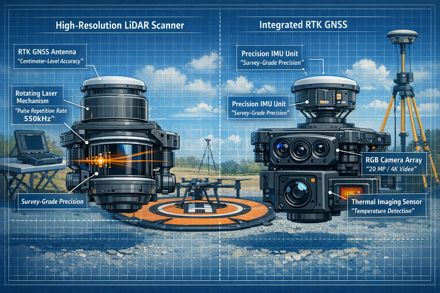
LiDAR Systems: The New Industry Standard
LiDAR (Light Detection and Ranging) technology has transitioned from specialized, expensive equipment to mainstream surveying tools in 2026. Modern LiDAR-enabled UAVs deliver several critical advantages that have made them the preferred choice for topographic mapping:[1]
- Faster Pulse Repetition Rates (PRR): Current systems achieve PRRs exceeding 550,000 pulses per second, enabling higher point density and more detailed terrain models
- Enhanced IMU Integration: Improved Inertial Measurement Units provide more accurate position and orientation data, critical for precise georeferencing
- Vegetation Penetration: LiDAR's ability to penetrate dense canopy and capture ground-level data makes it invaluable for forestry applications and heavily vegetated sites
- Multi-return Capability: Advanced systems capture multiple returns per pulse, enabling differentiation between vegetation layers and bare earth
The cost reduction in LiDAR technology has been dramatic. Systems that cost hundreds of thousands of dollars just five years ago are now available for a fraction of that investment, making the technology accessible to mid-sized surveying firms and specialized contractors.[1]
RTK/PPK GNSS: Achieving Centimeter-Level Accuracy
Real-Time Kinematic (RTK) and Post-Processed Kinematic (PPK) GNSS systems represent the accuracy breakthrough that elevated drone surveying to professional survey-grade standards. These technologies enable centimeter-level positional accuracy without extensive ground control point networks.[1]
RTK systems communicate with a base station in real-time during flight, applying corrections to GPS data as it's collected. This approach provides:
✅ Immediate accuracy verification during data collection
✅ Reduced post-processing time
✅ Confidence in data quality before leaving the site
PPK systems record raw GNSS data during flight and apply corrections during post-processing. This method offers:
✅ Greater operational flexibility in areas with communication challenges
✅ Ability to use multiple base station sources for corrections
✅ Potentially higher accuracy through extended processing algorithms
The advancement in RTK/PPK technology has fundamentally changed ground control point (GCP) requirements. While traditional photogrammetry workflows required numerous GCPs distributed throughout the survey area, modern RTK/PPK-enabled systems can achieve comparable accuracy with significantly fewer control points—or in some applications, none at all.[1] This reduction is particularly impactful for remote locations, linear infrastructure projects like utility corridors, and time-sensitive applications.
Complementary Sensor Technologies
Beyond LiDAR and GNSS, modern surveying drones integrate multiple sensor types to capture comprehensive site data:[1]
| Sensor Type | Primary Applications | Key Benefits |
|---|---|---|
| High-Resolution RGB | Orthomosaic creation, visual documentation | Detailed imagery, texture mapping, visual context |
| Multispectral | Agricultural assessment, vegetation analysis | Crop health monitoring, NDVI calculations, irrigation planning |
| Thermal Imaging | Infrastructure inspection, moisture detection | Heat loss identification, electrical fault detection, water intrusion mapping |
| Oblique Cameras | 3D modeling, façade inspection | Building information modeling, architectural documentation |
The integration of these sensors with onboard AI for real-time data validation represents a significant advancement in 2026. Intelligent systems can now identify data gaps, quality issues, or coverage problems during flight operations, enabling immediate corrective action rather than discovering problems during post-processing.[1]
For surveyors seeking to understand the broader context of professional surveying practices and qualifications, the integration of drone technology represents both an opportunity and a professional development requirement.
Selecting LiDAR-Equipped Drones for Professional Surveying Projects
Choosing the appropriate UAV platform for Drones in Land Surveying: Mastering UAV Applications for Accurate Topographic Mapping in 2026 requires careful evaluation of project requirements, operational constraints, and budget considerations. The market offers numerous options ranging from compact systems suitable for small sites to industrial-grade platforms designed for large-scale topographic mapping.
Critical Selection Criteria for Survey-Grade UAVs
When evaluating drone platforms for professional surveying applications, several factors determine suitability and long-term value:
1. Payload Capacity and Compatibility
The drone must accommodate the required sensor package while maintaining adequate flight time. LiDAR systems typically weigh between 600g and 2kg, with heavier systems generally offering superior performance. Consider:
- Maximum payload weight capacity
- Mounting options and sensor compatibility
- Impact of payload on flight duration
- Gimbal stabilization capabilities
2. Flight Performance Specifications
Operational efficiency depends heavily on flight performance characteristics:
- Flight time: 25-45 minutes typical for survey-grade platforms
- Maximum wind resistance: Critical for maintaining data quality in field conditions
- Operating temperature range: Important for year-round operations
- Maximum altitude capability: Relevant for mountainous terrain or high-elevation projects
3. GNSS Integration and Accuracy
The quality of integrated positioning systems directly impacts survey accuracy:
- RTK/PPK compatibility and implementation
- Multi-constellation GNSS support (GPS, GLONASS, Galileo, BeiDou)
- Horizontal and vertical accuracy specifications
- Base station compatibility and requirements
4. Data Capture and Storage
Survey projects generate massive datasets requiring robust data management:
- Onboard storage capacity (typically 256GB-1TB)
- Data transfer protocols and speeds
- Redundant storage options for mission-critical applications
- Real-time data streaming capabilities
5. Automation and Flight Planning
Advanced automation features significantly improve operational efficiency:
- Terrain-following capabilities for consistent ground sampling distance
- Automated flight planning software integration
- Obstacle avoidance systems
- Return-to-home and failsafe protocols
Platform Categories and Applications
Compact Survey Drones (< 2kg)
Ideal for small sites, rapid deployment, and projects with limited access. These platforms offer:
- Minimal regulatory requirements in many jurisdictions
- Quick setup and deployment
- Lower operational costs
- Suitable for sites under 50 acres
Mid-Range Professional Systems (2-7kg)
The workhorse category for most professional surveying applications:
- Balanced performance and portability
- Flight times of 30-40 minutes
- Suitable for sites up to 500 acres per mission
- Professional-grade sensor integration
Industrial Survey Platforms (> 7kg)
Designed for large-scale topographic mapping and demanding applications:
- Extended flight times (40+ minutes)
- Heavy payload capacity for multiple sensors
- Superior wind resistance and stability
- Suitable for mining, large infrastructure, and extensive corridor mapping
Budget Considerations and ROI Analysis
The investment in drone surveying equipment extends beyond the initial platform purchase. A comprehensive budget should account for:
💰 Initial Capital Investment
- Drone platform: $15,000 – $150,000+ depending on capabilities
- LiDAR sensor: $20,000 – $200,000+ for survey-grade systems
- RTK/PPK base station: $5,000 – $25,000
- Ground control point equipment: $3,000 – $10,000
- Processing workstation: $3,000 – $8,000
💰 Software Licensing
- Photogrammetry processing software: $2,000 – $10,000 annually
- LiDAR processing software: $3,000 – $15,000 annually
- CAD/GIS integration tools: $1,000 – $5,000 annually
💰 Operational Costs
- Insurance: $3,000 – $15,000 annually
- Training and certification: $1,500 – $5,000 per operator
- Maintenance and repairs: 10-15% of equipment value annually
- Battery replacement: $500 – $2,000 annually
Despite these investments, the ROI for professional surveying firms typically materializes within 12-24 months through reduced labor costs, increased project capacity, and competitive advantages in bidding.[2] A single UAV mission can accomplish work that would require multiple crews working for days, fundamentally changing the economics of surveying projects.
Understanding different types of surveyors and their specializations helps contextualize where drone technology fits within the broader surveying profession and which specializations benefit most from UAV integration.
Processing High-Resolution Data for Development Projects
Capturing high-quality drone data represents only the first phase of the surveying workflow. Transforming raw sensor data into actionable deliverables requires specialized software, technical expertise, and systematic processing workflows. Drones in Land Surveying: Mastering UAV Applications for Accurate Topographic Mapping in 2026 demands mastery of these post-processing techniques to deliver professional-grade results.
Photogrammetry Processing Workflows
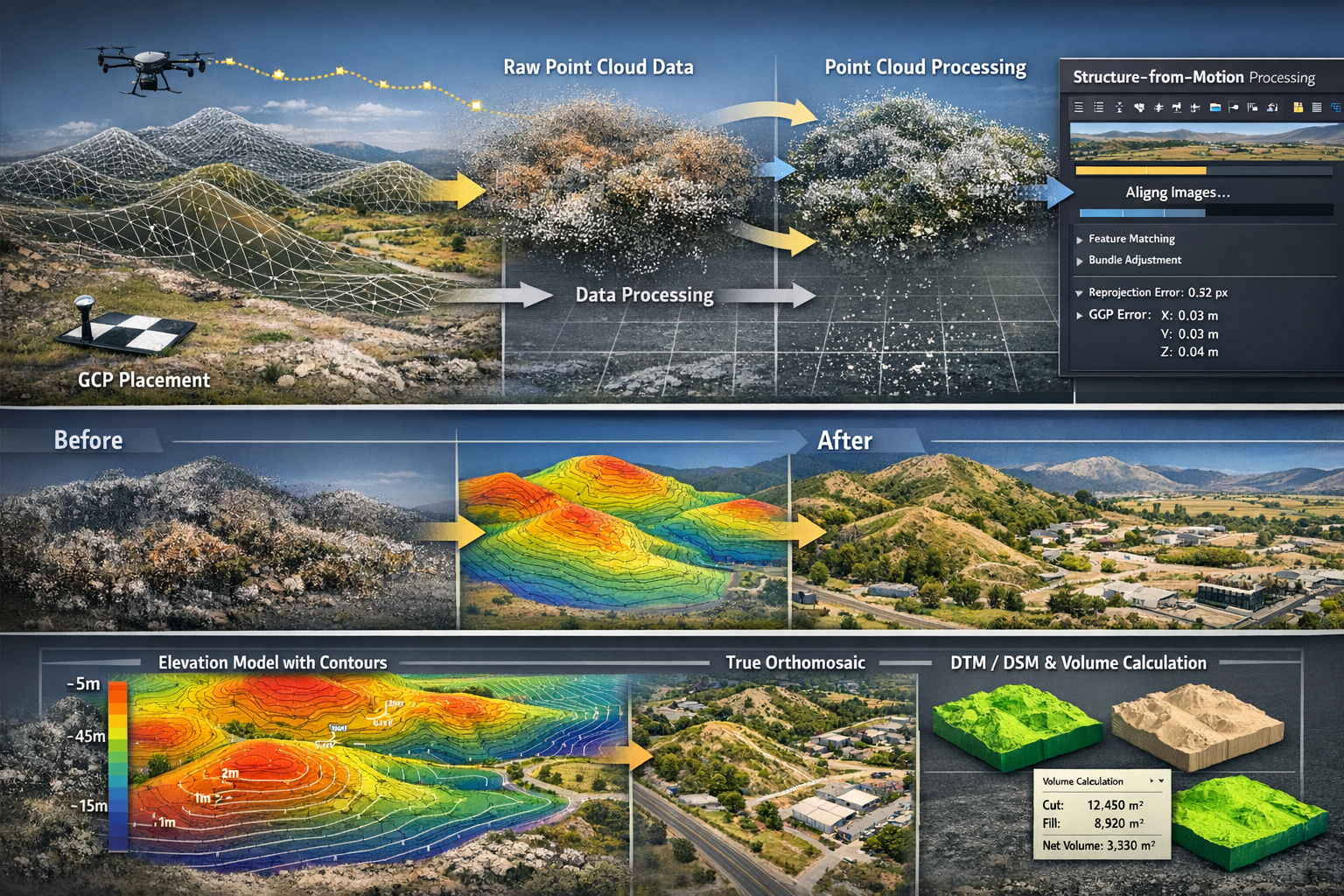
Photogrammetry—the science of making measurements from photographs—forms the foundation of RGB-based drone surveying. Modern Structure-from-Motion (SfM) algorithms can generate highly accurate 3D models and orthomosaic maps from overlapping images.[2]
Step 1: Image Import and Quality Assessment
Begin by importing captured imagery and conducting quality control:
- Verify image count and coverage completeness
- Check for blur, overexposure, or other quality issues
- Confirm GNSS data integrity and accuracy
- Remove problematic images that could degrade results
Step 2: Ground Control Point Integration
Even with RTK/PPK systems, strategic GCP placement improves accuracy:
- Identify GCP locations in multiple overlapping images
- Input surveyed GCP coordinates with appropriate precision
- Distribute GCPs throughout the project area, particularly at elevation changes
- Reserve check points for independent accuracy verification
Step 3: Image Alignment and Sparse Point Cloud Generation
The software identifies matching features across images and calculates camera positions:
- Feature detection and matching across image sets
- Bundle adjustment to optimize camera positions
- Sparse point cloud generation representing tie points
- Quality assessment of alignment results
Step 4: Dense Point Cloud Generation
Dense matching algorithms create detailed 3D point clouds:
- Multi-view stereo processing to maximize point density
- Quality settings balance processing time against detail level
- Typical outputs: 50-200 points per square meter
- Point cloud classification (ground, vegetation, buildings, etc.)
Step 5: Mesh, Orthomosaic, and DEM Generation
Transform point cloud data into usable deliverables:
- 3D Mesh: Textured surface model for visualization
- Orthomosaic: Geometrically corrected aerial imagery with uniform scale
- Digital Elevation Model (DEM): Raster representation of terrain elevation
- Digital Surface Model (DSM): Elevation including all surface features
- Digital Terrain Model (DTM): Bare earth elevation with vegetation removed
LiDAR Data Processing Workflows
LiDAR processing requires different approaches and specialized software to handle point cloud data and extract meaningful information.[1]
Point Cloud Cleaning and Classification
Raw LiDAR data requires refinement:
- Remove noise points (birds, atmospheric particles, sensor artifacts)
- Classify points by category (ground, vegetation, buildings, water, etc.)
- Apply automated classification algorithms with manual refinement
- Verify classification accuracy in representative areas
Ground Point Extraction and DTM Generation
Creating accurate bare-earth models:
- Filter classified ground points
- Apply interpolation algorithms to create continuous surface
- Verify results in areas of complex topography
- Generate contour lines at specified intervals (typically 0.5m – 2m)
Feature Extraction and Vectorization
Convert point cloud data to CAD/GIS-compatible formats:
- Extract building footprints and roof planes
- Identify utility infrastructure (poles, lines, towers)
- Delineate roadways, curbs, and paved surfaces
- Generate breaklines for natural features (streams, ridgelines, etc.)
Accuracy Assessment and Quality Control
Professional surveying demands rigorous quality verification:
Horizontal and Vertical Accuracy Metrics
Quantify deliverable accuracy using independent check points:
- Root Mean Square Error (RMSE) calculations
- Comparison against known survey monuments
- Assessment against project accuracy requirements
- Documentation of accuracy statistics in project reports
Visual Quality Inspection
Systematic review identifies processing artifacts:
- Orthomosaic seams and color balancing issues
- Point cloud gaps or low-density areas
- Mesh artifacts in complex geometry areas
- Contour line irregularities indicating processing problems
Deliverable Format Optimization
Prepare data in formats suitable for end-user applications:
- CAD formats (DWG, DXF) for engineering design
- GIS formats (GeoTIFF, LAS/LAZ, SHP) for spatial analysis
- BIM integration (RVT, IFC) for construction coordination
- Web-optimized formats for client review and collaboration
Software Solutions for 2026
The processing software landscape offers numerous options with varying capabilities and price points:
Photogrammetry Software
- Pix4Dmapper: Industry standard with comprehensive processing options
- Agisoft Metashape: Excellent accuracy and customization capabilities
- DroneDeploy: Cloud-based solution with simplified workflows
- WebODM: Open-source option for budget-conscious operators
LiDAR Processing Software
- Terrasolid: Professional-grade suite for complex projects
- LP360: Integrated solution for point cloud classification and feature extraction
- Global Mapper: Cost-effective option with broad format support
- PDAL: Open-source point cloud processing library
Integrated Survey Solutions
- Trimble Business Center: Comprehensive platform integrating drone and traditional survey data
- Leica Infinity: Professional survey processing with UAV data support
- Bentley ContextCapture: Enterprise-scale reality modeling
The selection of appropriate software depends on project complexity, output requirements, budget constraints, and integration with existing workflows. Many firms maintain licenses for multiple platforms to address different project types and client requirements.
For surveyors working on construction projects requiring detailed site documentation, drone-derived data provides unprecedented detail and accuracy for design, planning, and progress monitoring applications.
Navigating 2026 Regulatory Updates for Commercial Drone Operations
The regulatory landscape governing commercial drone operations has evolved significantly, with 2026 marking a maturation point where frameworks accommodate advanced applications while maintaining safety standards. Understanding and complying with these regulations is essential for Drones in Land Surveying: Mastering UAV Applications for Accurate Topographic Mapping in 2026 operations.
Remote ID: Full Implementation and Compliance
Remote ID technology, now fully integrated into airspace management systems, functions as a digital license plate for drones, broadcasting identification and location information to authorities and other airspace users.[1]
Compliance Requirements
All commercial drones operating in 2026 must:
- Broadcast Remote ID information during all flight operations
- Include operator location and drone position data
- Transmit unique identifier linked to registration database
- Maintain broadcast functionality throughout flight duration
Implementation Options
Operators can comply through:
- Built-in Remote ID: Integrated into drone firmware (standard on new platforms)
- Broadcast Module: Add-on device for legacy platforms
- Network-based Remote ID: Internet connectivity transmits required data
Operational Impact
Remote ID implementation has streamlined several operational aspects:
- Simplified airspace authorization processes
- Enhanced safety through increased situational awareness
- Reduced unauthorized operation incidents
- Foundation for advanced traffic management systems
BVLOS Operations: Expanded Commercial Approval
Beyond Visual Line of Sight (BVLOS) operations, once limited to experimental programs, are increasingly approved for commercial surveying applications in 2026.[1] This capability dramatically expands operational efficiency for linear infrastructure, large-area mapping, and remote site surveys.
Approval Pathways
Commercial BVLOS operations typically require:
- Demonstrated operational safety procedures
- Risk assessment and mitigation documentation
- Detect-and-avoid technology implementation
- Pilot training specific to BVLOS operations
- Insurance coverage appropriate to operational scope
Operational Considerations
Successful BVLOS surveying operations incorporate:
- Visual observers strategically positioned along flight path
- Redundant communication systems between drone and ground station
- Automated emergency procedures for communication loss scenarios
- Comprehensive pre-flight planning including emergency landing sites
- Coordination with air traffic control where required
Application Benefits
BVLOS capability particularly benefits:
- Utility corridor inspections extending many kilometers
- Pipeline and transmission line surveys
- Large-scale agricultural mapping
- Remote mining and quarry operations
- Coastal and waterway monitoring
Autonomous Systems and Drone-in-a-Box Solutions
Autonomous drone systems that operate without on-site pilots represent the cutting edge of commercial applications in 2026. These "drone-in-a-box" solutions enable continuous infrastructure monitoring and scheduled inspections.[1]
Regulatory Framework
Autonomous operations typically require:
- Enhanced safety protocols and redundant systems
- Remote pilot monitoring capabilities
- Automated flight termination systems
- Regular maintenance and system verification
- Specific airspace authorizations for operational areas
Applications in Surveying
Autonomous systems excel in:
- Construction progress monitoring: Scheduled daily or weekly flights
- Stockpile volumetric tracking: Automated inventory management
- Infrastructure inspection: Routine condition assessment
- Environmental monitoring: Consistent temporal data collection
- Security and site monitoring: Continuous surveillance capabilities
Airspace Authorization and Coordination
Operating in controlled airspace or near airports requires proper authorization:
LAANC (Low Altitude Authorization and Notification Capability)
Automated system providing near-instantaneous airspace authorizations:
- Real-time approval for operations in controlled airspace
- Integration with flight planning applications
- Altitude limitations based on proximity to airports
- Immediate authorization for qualifying operations
Special Airspace Considerations
Certain areas require additional coordination:
- Restricted areas: Military installations, government facilities
- Temporary flight restrictions: Special events, emergency operations
- Stadium and venue restrictions: Event-day limitations
- National parks and wilderness areas: Specific regulations apply
Insurance and Liability Considerations
Professional surveying operations require comprehensive insurance coverage:
Essential Coverage Types
- Hull insurance: Physical damage to drone equipment
- Liability coverage: Third-party injury or property damage
- Professional liability: Errors and omissions in survey deliverables
- Payload coverage: Protection for expensive sensors and equipment
Risk Management Practices
Minimize liability exposure through:
- Documented safety procedures and checklists
- Regular equipment maintenance and inspection
- Pilot training and proficiency requirements
- Incident reporting and investigation protocols
- Client contract review and appropriate limitation of liability clauses
Pilot Certification and Training Requirements
Commercial drone operations require appropriate pilot certification:
Part 107 Remote Pilot Certificate (or equivalent in other jurisdictions)
Requirements include:
- Aeronautical knowledge examination
- TSA security screening
- Recurrent testing every 24 months
- Age minimum of 16 years
Advanced Certifications
Specialized operations may require:
- BVLOS-specific training and endorsements
- Night operations training
- Operations over people certification
- Autonomous systems operator qualifications
Continuing Education
Maintaining proficiency requires:
- Regular flight practice and skill maintenance
- Software and technology training
- Regulatory update awareness
- Industry best practices and standards
Understanding the roles and responsibilities of professional surveyors provides context for how drone operations integrate into comprehensive surveying services and professional obligations.
Practical Applications Across Development Project Types
Drones in Land Surveying: Mastering UAV Applications for Accurate Topographic Mapping in 2026 finds applications across diverse project types, each with specific requirements and workflows. Understanding these applications helps surveyors identify opportunities and optimize approaches.
Construction Site Surveying and Progress Monitoring
Construction projects benefit enormously from drone surveying capabilities throughout the project lifecycle.[2]
Pre-Construction Baseline Surveys
Establish accurate existing conditions:
- Comprehensive topographic mapping for design development
- Volumetric analysis for cut/fill calculations
- Identification of existing utilities and infrastructure
- Environmental baseline documentation
- Drainage pattern analysis and watershed delineation
Construction Progress Monitoring
Periodic surveys provide real-time project insights:
- Weekly or monthly flights document construction advancement
- Overlay analysis compares actual progress against planned schedules
- Volumetric tracking monitors earthwork quantities and stockpiles
- Quality verification ensures construction aligns with design specifications
- Stakeholder communication through visual documentation and 3D models
As-Built Documentation
Final surveys capture completed project conditions:
- Comprehensive as-built topographic surveys
- Building and infrastructure location verification
- Grade and drainage confirmation
- Final volumetric calculations
- Deliverables integrated into facility management systems
Mining and Quarry Applications
The mining industry has become one of the largest adopters of drone surveying technology.[1]
Stockpile Volumetric Calculations
Accurate inventory management:
- Monthly or weekly stockpile surveys
- Precise volume calculations for material inventory
- Trend analysis for production tracking
- Financial reporting and valuation support
- Automated processing workflows for routine surveys
Pit Progression and Planning
Operational optimization through detailed mapping:
- High-resolution pit floor and wall mapping
- Slope stability monitoring and analysis
- Haul road planning and optimization
- Blast planning and design support
- Environmental compliance documentation
Safety and Inspection
Minimize personnel exposure to hazardous areas:
- Highwall inspection without personnel access
- Unstable area assessment from safe distances
- Post-blast damage assessment
- Equipment and infrastructure inspection
- Emergency response and incident documentation
Agricultural Land Assessment
Agricultural applications extend beyond traditional surveying into precision agriculture:[2]
Topographic Mapping for Irrigation Design
Optimize water management:
- Detailed elevation models for irrigation system design
- Drainage pattern identification and improvement
- Slope analysis for erosion risk assessment
- Precision grading specifications for land leveling
Crop Health and Vegetation Analysis
Multispectral sensors enable advanced assessment:
- NDVI (Normalized Difference Vegetation Index) mapping
- Crop stress identification and monitoring
- Irrigation effectiveness evaluation
- Yield prediction and optimization
- Pest and disease early detection
Carbon Storage and Environmental Monitoring
Support sustainability initiatives:
- Forest inventory and biomass estimation
- Carbon sequestration quantification
- Wetland delineation and monitoring
- Habitat assessment and conservation planning
- Environmental impact documentation[2]
Infrastructure Corridor Mapping
Linear infrastructure projects benefit from efficient corridor surveying:
Utility Corridor Surveys
Comprehensive documentation for:
- Transmission line route planning and design
- Pipeline corridor topographic mapping
- Right-of-way documentation and encroachment identification
- Vegetation management planning
- Access road planning and design
Transportation Infrastructure
Highway and rail applications:
- Route alignment surveying and optimization
- Earthwork quantity calculations
- Bridge and structure location surveys
- Drainage design support
- Environmental impact assessment
Urban Planning and Development
Municipal and urban development applications:
City-Wide Mapping Programs
Comprehensive urban documentation:
- Base map creation and updates
- 3D city model development
- Infrastructure inventory and condition assessment
- Flood modeling and stormwater management
- Urban growth monitoring and planning
Development Site Analysis
Support planning and zoning decisions:
- Site capacity and constraint analysis
- Viewshed and visual impact assessment
- Traffic and circulation planning support
- Environmental sensitivity mapping
- Public engagement and visualization
Emergency Response and Disaster Assessment
Rapid deployment capabilities support critical applications:
- Post-disaster damage assessment
- Flood extent mapping and monitoring
- Landslide and erosion documentation
- Search and rescue support
- Recovery planning and documentation
The versatility of drone surveying technology enables applications across virtually every sector requiring accurate spatial data. Success depends on understanding project-specific requirements, selecting appropriate sensors and platforms, and implementing workflows optimized for each application type.
For professionals managing comprehensive property surveys and assessments, drone technology provides complementary capabilities that enhance traditional surveying methods rather than replacing them entirely.
Integration with Traditional Surveying Methods
While Drones in Land Surveying: Mastering UAV Applications for Accurate Topographic Mapping in 2026 offers remarkable capabilities, optimal results often come from integrating UAV data with traditional surveying techniques. Understanding when and how to combine methods maximizes accuracy, efficiency, and project value.
Complementary Strengths of Different Survey Methods
Drone Surveying Excels At:
✅ Large area coverage with consistent accuracy
✅ Rapid data collection over extensive sites
✅ Difficult or dangerous terrain access
✅ Comprehensive visual documentation
✅ Cost-effective volumetric calculations
✅ Regular monitoring and temporal analysis
Traditional Surveying Excels At:
✅ Extreme precision for boundary and control surveys
✅ Subsurface utility location and verification
✅ Dense vegetation or obscured feature surveys
✅ Interior building measurements
✅ Legal boundary establishment and monumentation
✅ As-built verification of critical dimensions
Hybrid Workflow Strategies
Ground Control and Verification
Even with RTK/PPK systems, strategic ground surveying enhances results:
- Establish primary control network using total station or GNSS
- Survey ground control points with higher precision than drone system
- Conduct independent check point surveys for accuracy verification
- Monument critical points for future reference and project continuity
Feature Supplementation
Combine methods to capture complete site information:
- Use drones for general topography and large-area coverage
- Employ total stations for detailed building corners and property boundaries
- Integrate utility location data from ground-based detection methods
- Supplement with manual measurements in areas of poor drone visibility
Boundary and Property Surveys
Legal boundary surveys require specific approaches:
- Drone surveys provide excellent context and site understanding
- Traditional methods establish and monument legal boundaries
- Combined deliverables include aerial imagery with surveyed boundary overlay
- Enhanced visualization aids client understanding and decision-making
Data Integration Techniques
Modern survey processing software facilitates integration of multiple data sources:
Coordinate System Consistency
Ensure all data sources reference common coordinate systems:
- Establish project coordinate system and datum
- Transform all datasets to common reference frame
- Verify alignment through overlap analysis
- Document transformations and accuracy impacts
Point Cloud Merging
Combine drone and terrestrial laser scanning data:
- Register datasets using common control points
- Merge point clouds maintaining appropriate density
- Classify points by source for quality tracking
- Generate comprehensive models from integrated data
CAD Integration
Incorporate survey data into design workflows:
- Import drone-derived surfaces and contours
- Overlay traditionally surveyed features and boundaries
- Maintain data layers by source and accuracy level
- Enable design decisions based on comprehensive site information
Project Planning: Choosing the Right Approach
Decision Factors
Consider these elements when planning survey methodology:
| Factor | Favors Drone Survey | Favors Traditional Survey | Hybrid Approach |
|---|---|---|---|
| Site Size | > 5 acres | < 1 acre | 1-5 acres |
| Accuracy Required | ±5cm acceptable | ±1cm required | Varies by feature |
| Vegetation | Open or moderate | Dense canopy | Mixed conditions |
| Timeline | Days available | Weeks acceptable | Moderate timeline |
| Budget | Cost-sensitive | Accuracy-critical | Balanced priorities |
| Deliverables | Visual, volumetric | Legal, boundary | Comprehensive |
Cost-Benefit Analysis
Evaluate methodology based on project economics:
- Calculate labor hours for traditional survey approach
- Estimate drone survey costs including processing time
- Consider accuracy requirements and liability implications
- Factor in schedule constraints and opportunity costs
- Assess client expectations and deliverable requirements
Quality Assurance in Hybrid Workflows
Maintain quality standards across integrated datasets:
Accuracy Hierarchy
Establish clear accuracy levels for different data types:
- Primary control: Highest accuracy (±1cm or better)
- Secondary control and GCPs: Survey-grade (±2-3cm)
- Drone-derived features: Project-specific (±5-10cm typical)
- Supplementary data: Appropriate to application
Documentation Standards
Comprehensive documentation supports quality and defensibility:
- Survey methodology descriptions for all data sources
- Equipment specifications and calibration records
- Processing parameters and software versions
- Accuracy assessment results and verification procedures
- Metadata for all deliverable datasets
Professional Standards Compliance
Ensure all work meets applicable professional standards:
- Adherence to surveying board regulations
- Compliance with ALTA/NSPS standards where applicable
- Following manufacturer specifications and best practices
- Maintaining professional liability insurance coverage
- Seal and signature requirements for regulated deliverables
The integration of drone technology with traditional surveying methods represents the optimal approach for many projects, combining the efficiency and coverage of UAV systems with the precision and legal standing of conventional techniques. Successful surveyors in 2026 master both domains and understand when each provides the greatest value.
For those interested in understanding professional surveyor qualifications and credentials, the addition of drone operation expertise represents an increasingly important component of modern surveying competency.
Future Trends and Emerging Technologies
As we progress through 2026, Drones in Land Surveying: Mastering UAV Applications for Accurate Topographic Mapping in 2026 continues to evolve with emerging technologies and methodologies that will shape the profession's future.
Artificial Intelligence and Machine Learning Integration
AI-powered processing is transforming data workflows:
Automated Feature Extraction
Machine learning algorithms increasingly automate manual tasks:
- Automatic building footprint and roof plane extraction
- Utility infrastructure identification and classification
- Vegetation classification and biomass estimation
- Change detection between temporal datasets
- Anomaly identification in infrastructure inspection
Real-Time Quality Assessment
Onboard AI enables in-flight quality verification:[1]
- Coverage gap identification during mission execution
- Image quality assessment and automatic recapture
- Sensor calibration verification and adjustment
- Predictive maintenance alerts for equipment issues
Intelligent Processing Optimization
AI optimizes processing parameters:
- Automatic processing parameter selection
- Adaptive algorithms based on scene content
- Quality prediction before full processing
- Resource allocation optimization for large datasets
Advanced Sensor Development
Sensor technology continues advancing:
Improved LiDAR Systems
Next-generation capabilities include:
- Higher pulse repetition rates exceeding 1 million pulses/second
- Extended range for high-altitude mapping
- Improved multi-return processing for complex scenes
- Miniaturization enabling deployment on smaller platforms
Hyperspectral Imaging
Beyond multispectral capabilities:
- Hundreds of spectral bands for detailed material identification
- Enhanced vegetation species classification
- Mineral identification for geological surveys
- Pollution and contamination detection
Integrated Sensor Packages
Comprehensive data capture in single flights:
- Simultaneous LiDAR, RGB, multispectral, and thermal capture
- Synchronized data collection for perfect alignment
- Reduced flight time and operational costs
- Comprehensive datasets supporting multiple analysis types
Autonomous Operations Expansion
Automation continues advancing:[1]
Swarm Technology
Multiple drones operating cooperatively:
- Coordinated flights covering vast areas simultaneously
- Redundant coverage for mission-critical applications
- Specialized roles within drone teams
- Dramatically reduced survey time for large projects
Edge Computing
Onboard processing capabilities:
- Real-time data processing during flight
- Immediate deliverable generation
- Reduced data transfer requirements
- Field verification of results before demobilization
Regulatory Evolution
Frameworks continue adapting to technology:
Urban Air Mobility Integration
Preparation for increased airspace usage:
- Advanced traffic management systems
- Automated deconfliction protocols
- Standardized communication protocols
- Integration with manned aviation systems
International Harmonization
Increasing regulatory consistency:
- Cross-border operation frameworks
- Mutual recognition of certifications
- Standardized safety and operational requirements
- Facilitated international project work
Industry Standardization
Professional standards continue developing:
Data Deliverable Standards
Increasing consistency in outputs:
- Standardized accuracy specifications by application
- Common file formats and metadata requirements
- Quality assurance protocols and documentation
- Professional liability and insurance frameworks
Certification Programs
Specialized credentials emerging:
- Drone surveying professional certifications
- Sensor-specific operator qualifications
- Processing software proficiency credentials
- Industry-recognized competency standards
The future of drone surveying promises continued advancement in capability, efficiency, and accessibility. Professionals who maintain awareness of emerging technologies and invest in ongoing education will be best positioned to capitalize on these developments and deliver superior value to clients.
Conclusion: Mastering UAV Applications for Professional Success
Drones in Land Surveying: Mastering UAV Applications for Accurate Topographic Mapping in 2026 represents far more than adopting new technology—it requires developing comprehensive expertise spanning equipment selection, operational procedures, data processing workflows, regulatory compliance, and strategic integration with traditional methods. The transformation of surveying through UAV technology has fundamentally altered the profession's economics, capabilities, and competitive landscape.
The achievement of centimeter-level accuracy through integrated RTK/PPK GNSS systems, combined with the mainstream adoption of LiDAR technology, has elevated drone surveying from a supplementary tool to a primary methodology for topographic mapping across industries.[1] Survey-grade results that once required extensive field crews working for days or weeks can now be accomplished in hours with minimal personnel, dramatically improving project economics while maintaining professional accuracy standards.[1][2]
However, success requires more than equipment investment. Professional surveyors must develop technical proficiency in sensor technologies, master complex data processing workflows, navigate evolving regulatory frameworks, and understand when drone methods provide optimal value versus traditional approaches. The integration of multiple data sources—combining drone-derived topography with traditionally surveyed control and boundaries—often delivers superior results compared to any single methodology.
Actionable Next Steps for Surveying Professionals
For Firms Beginning Drone Integration:
- Assess operational requirements based on typical project types and client needs
- Develop business case analyzing costs, ROI timeline, and competitive positioning
- Invest in training before equipment, ensuring personnel can maximize technology value
- Start with rental or service provider partnerships to gain experience before capital investment
- Establish processing workflows and quality control procedures from the outset
- Obtain appropriate insurance and ensure regulatory compliance before operations
For Established Drone Operations Seeking Advancement:
- Evaluate sensor upgrades particularly LiDAR integration if not currently deployed
- Implement RTK/PPK systems to reduce ground control requirements and improve efficiency
- Develop specialized expertise in high-value applications (mining, construction, infrastructure)
- Pursue BVLOS authorization where applicable to expand operational capabilities
- Invest in processing automation to improve turnaround time and reduce labor costs
- Consider autonomous systems for routine monitoring and inspection applications
For All Professionals:
- Maintain regulatory awareness as frameworks continue evolving
- Invest in continuing education covering emerging technologies and methodologies
- Develop strategic partnerships with complementary service providers
- Document workflows and quality procedures to ensure consistency and defensibility
- Engage with industry organizations to influence standards development and share best practices
- Communicate value effectively to clients, emphasizing accuracy, efficiency, and comprehensive deliverables
The surveying profession has entered an era where UAV technology is not optional but essential for competitive practice. Those who master Drones in Land Surveying: Mastering UAV Applications for Accurate Topographic Mapping in 2026 will find themselves well-positioned to deliver superior value, win competitive projects, and build sustainable practices in an evolving industry landscape.
The technology will continue advancing—sensors will improve, processing will accelerate, automation will expand, and regulatory frameworks will adapt. The fundamental requirement for accurate spatial data, however, remains constant. Professional surveyors who combine traditional expertise with advanced UAV capabilities will continue serving essential roles in construction, development, infrastructure, agriculture, and environmental management for decades to come.
The future of surveying is aerial, autonomous, and data-rich. The time to develop mastery is now.
References
[1] How Drones Are Transforming Surveying Mapping And Inspection In 2026 – https://www.uavsphere.com/post/how-drones-are-transforming-surveying-mapping-and-inspection-in-2026
[2] Drone Surveying – https://uavcoach.com/drone-surveying/