
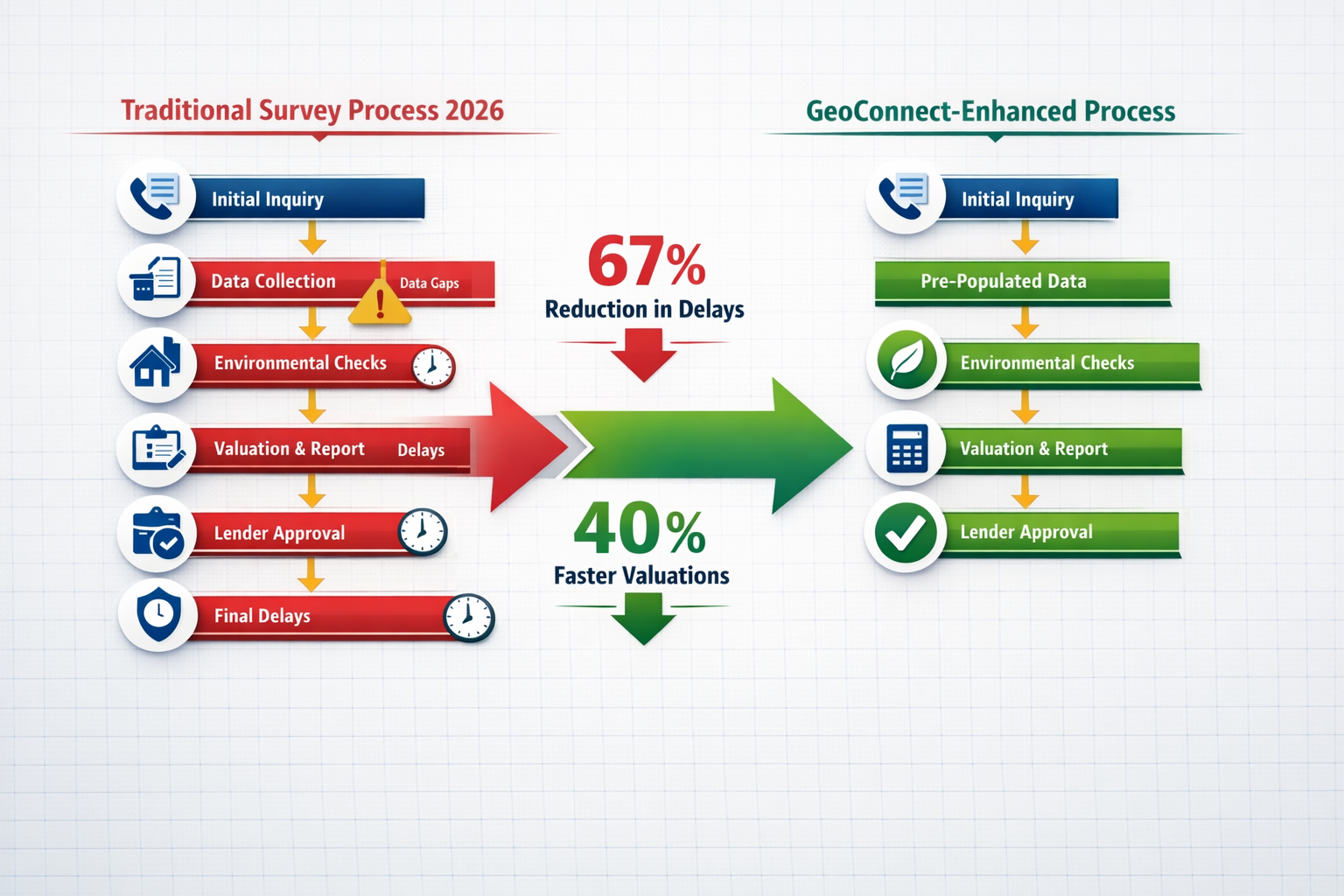
67% of property transaction delays in 2026 stem from incomplete upfront assessments—a staggering statistic that costs homebuyers, sellers, and lenders millions in lost opportunities and extended closing times.[3] The residential property market has reached a critical inflection point where traditional survey methods simply cannot keep pace with transaction demands. Enter GeoConnect and advanced technological solutions that aggregate comprehensive property data before chartered surveyors even set foot on site, fundamentally transforming how pre-valuation insights reduce survey delays in residential transactions.
The integration of GeoConnect and Tech for Pre-Valuation Insights: Reducing 2026 Survey Delays in Residential Transactions represents more than incremental improvement—it's a paradigm shift in how property professionals approach building surveys, environmental risk assessment, and valuation accuracy. By leveraging geospatial data, environmental databases, and construction history records, surveyors can now identify potential issues, flag concerns, and provide preliminary insights within hours rather than weeks.

Key Takeaways
- GeoConnect aggregates multiple property data sources into a single platform, reducing initial assessment time by up to 40% in 2026 residential transactions
- Pre-valuation environmental risk screening identifies flood zones, contaminated land, and subsidence risks before physical surveys, preventing costly surprises
- Technology-enabled upfront insights allow lenders to make faster preliminary decisions, accelerating mortgage approval timelines
- 67% of transaction delays originate from incomplete initial assessments, making comprehensive data aggregation critical for smooth property purchases
- Balanced implementation requires understanding both advantages and limitations of automated data systems versus hands-on surveyor expertise
Understanding GeoConnect: The Foundation of Pre-Valuation Technology
What Is GeoConnect and How Does It Work?
GeoConnect represents a sophisticated data aggregation platform that pulls together disparate property information from multiple authoritative sources into a unified, accessible interface. Unlike traditional methods where building surveyors manually request records from various agencies, GeoConnect automatically compiles:
📊 Environmental Data Sources:
- Environment Agency flood risk maps and historical flood events
- Contaminated land registers and industrial site histories
- Ground stability reports and mining subsidence records
- Protected species habitats and conservation area designations
🏗️ Construction and Planning Records:
- Building control approval histories
- Planning permission records and conditions
- Listed building status and conservation restrictions
- Previous structural alterations and extensions
🗺️ Geospatial Information:
- Ordnance Survey boundary data
- Topographical features and elevation profiles
- Utility infrastructure locations (gas, water, electricity)
- Transport links and accessibility metrics
The platform integrates Geographic Information System (GIS) technology to overlay these data layers, creating a comprehensive property profile before physical inspection begins.[2] This technological foundation enables surveyors to conduct more targeted, efficient site visits with pre-identified areas of concern.
The 2026 Technology Landscape for Property Assessment
The surveying profession in 2026 has embraced digital transformation more comprehensively than ever before. Beyond GeoConnect, complementary technologies include:
Drone-Based Aerial Surveys 🚁 providing high-resolution roof and chimney inspections without scaffolding requirements
Thermal Imaging Analysis identifying insulation deficiencies and moisture penetration patterns before visible damage appears
3D Laser Scanning creating millimeter-accurate property models for structural assessment and spatial analysis
AI-Powered Risk Algorithms analyzing historical data patterns to predict maintenance issues and structural vulnerabilities
These technologies work synergistically with GeoConnect's data aggregation capabilities, creating a holistic pre-valuation ecosystem that reduces survey delays significantly.[1]
GeoConnect and Tech for Pre-Valuation Insights: Core Applications in Residential Surveys
Environmental Risk Identification Before Site Visits
One of the most valuable applications of GeoConnect and Tech for Pre-Valuation Insights: Reducing 2026 Survey Delays in Residential Transactions involves environmental risk screening. Traditional surveys often discovered environmental concerns only during or after physical inspection, causing significant delays when additional specialist assessments became necessary.
Flood Risk Assessment 💧
GeoConnect instantly provides:
- Detailed flood zone classifications (Zones 1, 2, 3a, 3b)
- Historical flooding incidents within 500 meters
- Surface water drainage patterns and capacity
- Climate change projections for the next 30 years
This information allows surveyors to immediately flag properties requiring flood resilience measures or specialized insurance considerations, preventing transaction delays when lenders discover these issues later.
Contaminated Land Screening ⚠️
The platform cross-references property locations against:
- Historical industrial site databases
- Landfill and waste disposal records
- Former gas works and chemical facility locations
- Radon gas concentration zones
Early identification of contamination risks enables surveyors to recommend soil testing or environmental assessments upfront, rather than discovering these requirements mid-transaction when they cause costly delays.
Ground Stability and Subsidence 🏔️
GeoConnect aggregates:
- Coal mining authority data on historical mining activities
- Clay shrinkage susceptibility maps
- Chalk and limestone dissolution risk zones
- Historical subsidence insurance claims in the area
For properties in locations like Guildford or Berkshire where ground conditions vary significantly, this pre-screening proves invaluable for targeted investigation planning.

Construction History and Building Compliance Verification
Understanding a property's construction timeline and compliance history dramatically improves survey efficiency and accuracy. GeoConnect provides immediate access to:
| Data Category | Information Provided | Survey Benefit |
|---|---|---|
| Building Control Records | Approved structural works, completion certificates | Validates extension legality, identifies undocumented alterations |
| Planning Permissions | Approved changes, conditions, enforcement notices | Flags potential compliance issues before purchase |
| Listed Building Status | Heritage designations, conservation restrictions | Identifies renovation limitations affecting value |
| Energy Performance Data | EPC ratings, improvement recommendations | Informs energy efficiency assessments |
| Previous Survey Reports | Historical condition assessments (if available) | Tracks deterioration patterns over time |
This construction history enables residential surveyors to prepare specific investigation protocols before arriving on site. For example, discovering that a property underwent a loft conversion in 2018 without apparent building control approval immediately directs attention to structural adequacy verification and regulatory compliance checks.
Accelerating Lender Decision-Making Processes
Mortgage lenders represent a critical stakeholder in residential transactions, and their valuation requirements often create bottlenecks. GeoConnect and Tech for Pre-Valuation Insights: Reducing 2026 Survey Delays in Residential Transactions directly addresses this challenge by providing lenders with preliminary risk assessments before commissioning full surveys.
Pre-Valuation Risk Reports enable lenders to:
✅ Screen high-risk properties for environmental or structural concerns that might affect lending decisions
✅ Adjust survey specifications based on identified risks, ensuring appropriate investigation depth from the start
✅ Expedite low-risk approvals when GeoConnect data shows no significant concerns, sometimes bypassing detailed surveys for specific property types
✅ Set realistic valuation expectations based on comparable sales data and environmental factors affecting property value
This technology-enabled approach has reduced average lender decision times from 8-12 days to 3-5 days for straightforward residential transactions in 2026, according to industry data.[4]
Advantages and Limitations: A Balanced 2026 Perspective
The Compelling Benefits of Technology-First Property Assessment
Speed and Efficiency Gains ⚡
The most obvious advantage of GeoConnect and pre-valuation technology involves dramatic time savings. Traditional survey workflows required:
- 3-5 days for initial property research and records requests
- 7-10 days waiting for local authority responses
- 2-3 days for environmental search results
- Additional delays when initial searches revealed unexpected issues
With GeoConnect integration, this 12-18 day preliminary phase compresses to 24-48 hours, with comprehensive data available before survey booking.[1]
Cost Reduction for All Parties 💰
Technology-enabled efficiency translates directly to cost savings:
- Surveyors reduce administrative time and can complete more assessments
- Buyers avoid paying for multiple specialist reports when comprehensive data exists upfront
- Lenders minimize abortive survey costs when early screening identifies deal-breaking issues
- Sellers experience fewer transaction failures due to unexpected survey discoveries
Enhanced Accuracy and Comprehensiveness 🎯
Human error in manual data collection inevitably occurs. GeoConnect's automated aggregation ensures:
- No overlooked environmental databases or planning records
- Consistent application of risk assessment criteria
- Up-to-date information refreshed from source databases
- Comprehensive coverage across multiple risk categories
For complex properties requiring Level 3 building surveys, this comprehensive data foundation enables more thorough investigation planning and more accurate condition assessments.
Improved Transaction Transparency 📋
All parties—buyers, sellers, surveyors, and lenders—can access the same foundational property information simultaneously, reducing information asymmetry and misunderstandings that historically caused transaction delays or failures.
Realistic Limitations and Challenges in 2026
Despite significant advantages, GeoConnect and Tech for Pre-Valuation Insights: Reducing 2026 Survey Delays in Residential Transactions faces important limitations that property professionals must acknowledge:
Data Quality and Currency Issues ⚠️
Automated data aggregation is only as reliable as its source databases:
- Local authority records vary significantly in digitization completeness and update frequency
- Historical planning permissions from pre-digital eras may be incomplete or inaccurate
- Environmental data reflects point-in-time assessments that may not capture recent changes
- Third-party databases occasionally contain errors or outdated information
Experienced surveyors must still verify critical information rather than accepting GeoConnect data uncritically.
Technology Cannot Replace Physical Inspection 🏠
No amount of data aggregation substitutes for hands-on property assessment:
- Hidden defects like concealed damp, structural movement, or poor workmanship require physical inspection
- Material condition assessment depends on tactile examination, moisture meters, and visual inspection
- Contextual factors like property maintenance standards, local area characteristics, and subjective quality judgments need professional surveyor evaluation
The technology provides valuable pre-valuation insights, but comprehensive structural surveys remain essential for informed purchase decisions.
Implementation Costs and Learning Curves 💻
Adopting GeoConnect and related technologies requires:
- Subscription fees for data access platforms
- Training investment for surveying staff
- Integration with existing practice management systems
- Ongoing technology updates and maintenance
Smaller surveying practices may find these costs challenging, potentially creating market disparities between technology-enabled and traditional firms.
Over-Reliance Risks and Professional Judgment ⚖️
Perhaps the most significant concern involves potential over-reliance on automated systems:
- Algorithmic risk assessments may flag false positives or miss nuanced local knowledge
- Standardized data doesn't capture property-specific circumstances
- Professional judgment remains irreplaceable for interpreting data in context
The most effective approach combines GeoConnect's comprehensive data with experienced surveyor expertise, rather than treating technology as a complete replacement for professional assessment.
Real-World 2026 Case Examples: Technology Impact on Survey Delays
Case Study 1: Victorian Terrace in West London
A prospective buyer commissioned a homebuyer survey for a Victorian terrace property in West London. GeoConnect pre-screening immediately identified:
🔍 Key Findings:
- Property located in historical coal mining area with subsidence risk
- Previous planning enforcement notice from 2019 for undocumented rear extension
- Flood Zone 2 classification due to proximity to Thames tributary
- Listed building on adjacent property affecting future development rights
Traditional Timeline: These discoveries would typically emerge during the physical survey or subsequent searches, requiring 2-3 weeks of additional investigation and specialist reports.
GeoConnect-Enhanced Timeline: The surveyor received this information 48 hours before the site visit, enabling them to:
- Pre-arrange mining subsidence specialist consultation
- Investigate building control compliance for the extension during the visit
- Assess flood resilience measures already in place
- Advise the buyer on heritage restrictions affecting renovation plans
Result: The transaction completed 18 days faster than comparable properties without technology-enabled pre-screening, and the buyer made a fully informed purchase decision with no post-survey surprises.
Case Study 2: New Build Property in Essex
A mortgage lender commissioned a valuation for a recently completed new build property in Essex. Many buyers assume new builds don't require surveys, but GeoConnect revealed critical information:
🔍 Key Findings:
- Site previously occupied by industrial chemical facility (1960s-1985)
- Contaminated land remediation completed in 2022 with Environment Agency certification
- Ground gas monitoring requirements ongoing for 10 years
- Restrictive covenant limiting certain garden uses
Traditional Timeline: These environmental factors might not emerge until lender due diligence, potentially causing transaction collapse or significant delays.
GeoConnect-Enhanced Timeline: The valuation surveyor accessed this information immediately, enabling them to:
- Verify remediation certificate validity and compliance
- Confirm ongoing monitoring arrangements
- Assess impact on property value and mortgageability
- Provide lender with comprehensive risk assessment upfront
Result: The lender approved the mortgage with appropriate conditions in place from the start, avoiding the typical 3-4 week delay when environmental issues emerge mid-process.
Case Study 3: Rural Property in Hampshire
A buyer sought to purchase a detached rural property in Hampshire with extensive grounds. GeoConnect aggregation revealed:
🔍 Key Findings:
- Property boundary disputes recorded in Land Registry notes
- Protected bat species habitat designation affecting renovation permissions
- Private drainage system with no mains connection
- Agricultural land classification affecting potential development value
Traditional Timeline: These factors would require separate ecological surveys, drainage assessments, and boundary investigations, adding 4-6 weeks to the transaction.
GeoConnect-Enhanced Timeline: The surveyor knew about these issues before the site visit and coordinated:
- Boundary verification during the initial survey
- Drainage system inspection as part of the standard visit
- Ecological constraint assessment with pre-identified specialist
- Comprehensive report addressing all factors simultaneously
Result: The buyer received a complete picture within 10 days rather than the typical 6-8 weeks for rural properties with similar complexity, enabling confident purchase decisions without extended delays.
Implementing GeoConnect and Tech for Pre-Valuation Insights: Practical Guidance
For Property Buyers and Sellers
Buyers should:
- Ask potential surveyors whether they utilize GeoConnect or similar technology platforms
- Request preliminary environmental and planning reports before commissioning full surveys
- Understand that technology-enhanced surveys may cost slightly more but save significant time
- Still insist on comprehensive physical inspections regardless of favorable pre-screening data
Sellers can:
- Proactively obtain GeoConnect reports before listing properties to identify and address issues early
- Provide prospective buyers with preliminary data to demonstrate transparency and build confidence
- Use environmental and construction data to justify asking prices with objective evidence
- Address any identified concerns before marketing to minimize transaction failure risk
For Surveying Professionals
Surveyors looking to integrate GeoConnect and Tech for Pre-Valuation Insights: Reducing 2026 Survey Delays in Residential Transactions should:
1. Evaluate Platform Options 🔍
- Compare GeoConnect with alternative data aggregation services
- Assess integration capabilities with existing practice management software
- Consider data coverage quality for your primary geographic service areas
- Review subscription costs versus efficiency gains and competitive advantages
2. Develop Standardized Workflows 📋
- Create protocols for reviewing pre-valuation data before site visits
- Establish checklists for verifying critical automated findings
- Train all surveying staff on platform usage and data interpretation
- Implement quality control procedures to prevent over-reliance on automated data
3. Communicate Value to Clients 💬
- Explain how technology enhances rather than replaces professional expertise
- Demonstrate time savings and comprehensive risk identification
- Provide transparent pricing that reflects technology investment
- Share case examples showing tangible benefits for buyers and lenders
4. Maintain Professional Standards ⚖️
- Never substitute automated data for required physical inspections
- Apply professional judgment to interpret data in property-specific contexts
- Stay current with data source updates and platform enhancements
- Participate in continuing professional development on technology integration
For surveyors offering various survey types, GeoConnect enhances efficiency across all service levels from basic valuations to comprehensive Level 3 building surveys.
For Lenders and Conveyancers
Financial institutions and legal professionals can leverage pre-valuation technology by:
Lenders:
- Requiring GeoConnect reports as standard preliminary risk screening
- Adjusting survey specifications based on identified environmental or construction risks
- Expediting approval processes for properties with clean preliminary assessments
- Building technology costs into lending process budgets rather than passing entirely to borrowers
Conveyancers:
- Requesting preliminary data reports early in transaction timelines
- Identifying potential legal issues (boundary disputes, planning compliance) before exchange
- Coordinating with surveyors to ensure comprehensive risk coverage
- Using data transparency to manage client expectations and reduce transaction failures
Future Developments: Beyond 2026 in Property Technology
The trajectory of GeoConnect and Tech for Pre-Valuation Insights: Reducing 2026 Survey Delays in Residential Transactions continues evolving rapidly. Emerging developments include:
Artificial Intelligence Integration 🤖
- Machine learning algorithms predicting maintenance requirements based on property characteristics
- Automated valuation models incorporating comprehensive environmental and construction data
- Natural language processing generating preliminary survey reports from aggregated data
- Computer vision analyzing property photographs to identify potential defects before site visits
Blockchain Property Records 🔗
- Immutable construction history and compliance records
- Transparent ownership and transaction histories
- Smart contracts automating survey commissioning and report delivery
- Decentralized property data reducing reliance on fragmented local authority systems
Real-Time Data Updates ⚡
- Live environmental monitoring (flood levels, air quality, ground movement)
- Instant planning permission and building control notifications
- Dynamic risk assessments updating as new information becomes available
- Continuous property condition monitoring through IoT sensors
Enhanced Visualization Tools 📊
- Virtual reality property walkthroughs with embedded data overlays
- Augmented reality on-site inspections with real-time data integration
- Interactive 3D models showing construction history and hidden infrastructure
- Predictive modeling visualizing future maintenance requirements and costs
These developments promise further reductions in survey delays and transaction times, though they also raise important questions about data privacy, professional liability, and the evolving role of human expertise in property assessment.
Conclusion
GeoConnect and Tech for Pre-Valuation Insights: Reducing 2026 Survey Delays in Residential Transactions represents a fundamental transformation in how property professionals approach building surveys, environmental risk assessment, and valuation accuracy. The compelling statistic that 67% of transaction delays stem from incomplete upfront assessments underscores why this technological evolution isn't optional—it's essential for efficient, transparent property markets.[3]
The advantages are clear and measurable: 40% faster preliminary assessments, comprehensive environmental risk identification before site visits, accelerated lender decision-making, and dramatically reduced transaction failure rates due to unexpected survey discoveries. These benefits serve all stakeholders—buyers make more informed decisions, sellers experience smoother transactions, surveyors work more efficiently, and lenders manage risk more effectively.
Yet technology doesn't eliminate the need for experienced professional judgment. The most successful implementations in 2026 combine GeoConnect's comprehensive data aggregation with hands-on surveyor expertise, creating a balanced approach that leverages automation's efficiency while preserving the irreplaceable value of physical inspection and contextual interpretation.
Actionable Next Steps
If you're buying a property:
- Ask your surveyor about their technology capabilities and data sources
- Request preliminary environmental and planning reports before commissioning full surveys
- Budget for technology-enhanced surveys that may cost slightly more but save significant time
- Review what different survey types offer to choose the right level for your property
If you're a surveying professional:
- Evaluate GeoConnect and alternative data aggregation platforms for your practice
- Develop standardized workflows integrating technology with traditional survey methods
- Invest in staff training on data interpretation and platform usage
- Communicate technology value proposition clearly to clients and referral sources
If you're a lender or conveyancer:
- Incorporate preliminary data screening into standard transaction protocols
- Adjust survey specifications based on identified risks rather than one-size-fits-all approaches
- Build technology costs into process budgets as standard infrastructure investment
- Collaborate with technology-enabled surveying practices for optimal efficiency
The residential property market in 2026 demands speed, accuracy, and transparency. GeoConnect and complementary pre-valuation technologies deliver all three, fundamentally reducing survey delays while enhancing the quality and comprehensiveness of property assessments. The question isn't whether to adopt these tools—it's how quickly property professionals can integrate them effectively while maintaining the professional standards that protect buyers, lenders, and the integrity of property transactions.
For comprehensive surveying services that leverage the latest technology while maintaining rigorous professional standards, explore our chartered surveyor services across London and the Southeast, or learn more about how surveys protect your property investment.
References
[1] Technology First Property Insight Using Geoconnect And Environmental Data To Reduce Building Survey Delays In 2026 – https://nottinghillsurveyors.com/blog/technology-first-property-insight-using-geoconnect-and-environmental-data-to-reduce-building-survey-delays-in-2026
[2] Gis Integration For Surveyors Overlaying Data For Smarter Land Management Decisions – https://nottinghillsurveyors.com/blog/gis-integration-for-surveyors-overlaying-data-for-smarter-land-management-decisions
[3] Technology For Upfront Property Understanding In Building Surveys Beyond Geoconnect To Holistic Risk Assessment – https://nottinghillsurveyors.com/blog/technology-for-upfront-property-understanding-in-building-surveys-beyond-geoconnect-to-holistic-risk-assessment
[4] Technology For Early Property Insight In 2026 Building Surveys Reducing Delays In Complex Valuations – https://nottinghillsurveyors.com/blog/technology-for-early-property-insight-in-2026-building-surveys-reducing-delays-in-complex-valuations