
Building survey delays cost the UK property market an estimated £270 million annually in extended transaction times, yet the bottleneck isn't data availability—it's how effectively surveyors aggregate and utilize information at the point of instruction. In 2026, the surveying profession faces a fundamental shift: from reactive assessment to proactive insight generation through technology platforms that consolidate multi-source property intelligence before valuations even begin.
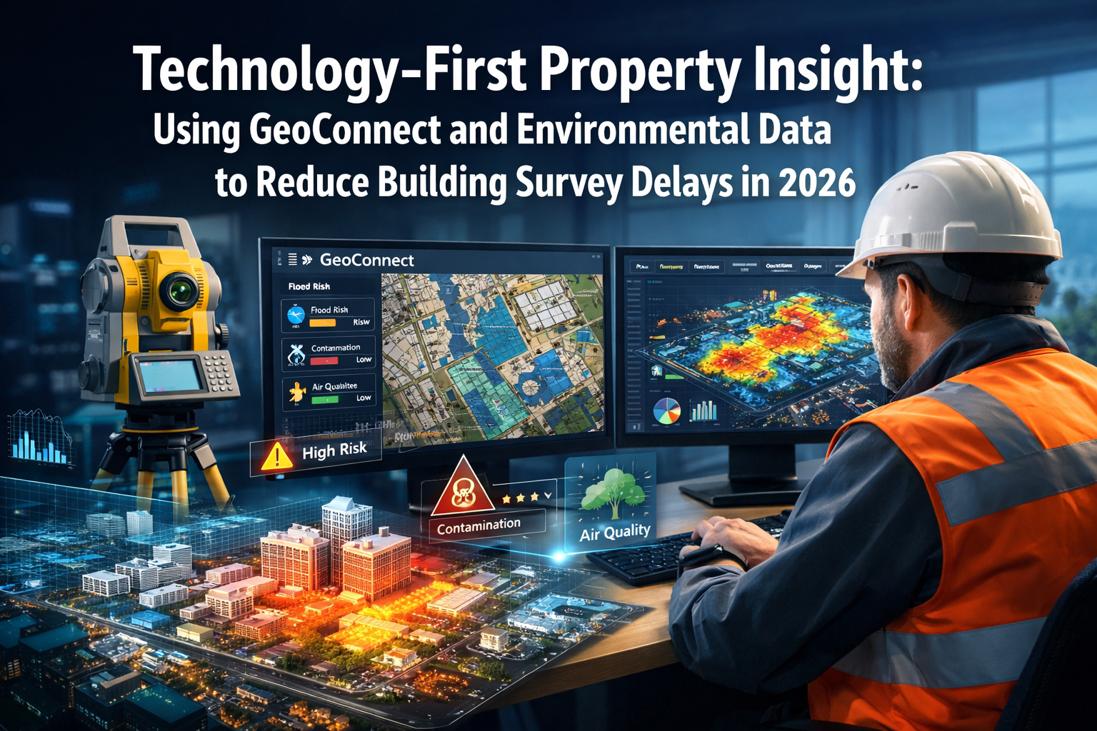
The Technology-First Property Insight: Using GeoConnect and Environmental Data to Reduce Building Survey Delays in 2026 approach represents this paradigm shift. Rather than waiting for issues to emerge during physical inspections, modern surveyors now leverage aggregated data platforms to build comprehensive risk profiles upfront, reducing follow-up queries by up to 60% and accelerating transaction timelines significantly.[1]
Key Takeaways
- Data aggregation platforms like GeoConnect consolidate property-specific information from multiple sources at instruction point, enabling early risk assessment before physical valuations
- Environmental data integration now combines flood risk, subsidence potential, energy efficiency, and climate resilience factors with construction type and market context for balanced lending decisions
- Parallel workflows with real-time synchronization allow multiple stakeholders to collaborate simultaneously, eliminating sequential communication delays that traditionally extended survey timelines
- Predictive analytics tools anticipate potential property issues before they arise, reducing the need for repeat surveys and follow-up investigations
- Long-term resilience assessment has become central to 2026 valuations, with surveyors evaluating not just current value but future maintenance requirements and adaptation potential
Understanding the 2026 Survey Delay Challenge
The Data Utilization Gap
The primary obstacle facing surveying in 2026 is not obtaining data—it's how effectively information is gathered and used at the beginning of the valuation process.[1] Traditional survey workflows relied on sequential information gathering: instruct surveyor, conduct physical inspection, identify issues, request additional data, analyze findings, produce report. Each step added days or weeks to transaction timelines.
Modern property transactions involve increasingly complex assets:
- 🏢 High-rise blocks with shared infrastructure
- 🏗️ Non-standard construction materials requiring specialist knowledge
- ♿ Adapted homes with accessibility modifications
- 🌱 Properties with renewable energy installations
- 📱 Smart buildings with integrated monitoring systems
These property types, once considered unusual, are now standard in everyday lending, requiring enhanced upfront analysis that traditional sequential workflows cannot deliver efficiently.[1]
The Cost of Delayed Insight
Survey delays create cascading problems throughout property transactions:
| Delay Impact | Consequence | Cost to Stakeholders |
|---|---|---|
| Extended timelines | Increased holding costs | £1,200-£3,500 per month |
| Repeat surveys | Additional professional fees | £400-£1,200 per survey |
| Follow-up queries | Transaction uncertainty | Lost deals, renegotiation |
| Sequential workflows | Opportunity cost | Delayed market entry |
| Incomplete risk profiles | Post-purchase surprises | £5,000-£50,000+ remediation |
For homebuyers, these delays translate into extended temporary accommodation costs, storage fees, and mortgage offer expiration risks. For lenders, they mean reduced loan origination volumes and increased operational costs. For surveyors, they result in client dissatisfaction and reputational damage.
Understanding how long house surveys typically take helps contextualize why technology-driven efficiency gains matter so significantly in 2026's competitive property market.
Technology-First Property Insight: The GeoConnect Revolution
What GeoConnect Brings to Modern Surveying
GeoConnect and similar aggregation platforms are specifically designed to bring together property-specific information from multiple sources at the point of instruction, enabling early assessment before valuation decisions.[1] Rather than functioning as simple databases, these platforms act as intelligent integration hubs that synthesize disparate data streams into actionable property intelligence.
Core GeoConnect capabilities include:
✅ Multi-source data aggregation – Land registry records, planning history, environmental databases, utility connections, and historical transaction data consolidated in single interface
✅ Real-time environmental overlays – Flood risk zones, subsidence susceptibility, contaminated land registers, radon levels, and climate projection data mapped to specific property locations
✅ Construction type identification – Building material databases, non-standard construction flags, listed building status, and conservation area restrictions automatically flagged
✅ Historical context integration – Previous survey reports, insurance claims, planning applications, and building control records linked to property timeline
✅ Smart building data feeds – For properties with existing smart systems, historical environmental and structural data can now be shared to support more informed initial assessments[2]
Beyond Simple Data Access: Intelligent Risk Profiling
The transformative aspect of Technology-First Property Insight: Using GeoConnect and Environmental Data to Reduce Building Survey Delays in 2026 isn't merely accessing information—it's the intelligent synthesis that creates actionable risk profiles before physical inspections begin.
Modern platforms employ predictive analytics to identify potential issues based on property characteristics, location factors, and historical patterns. When a surveyor receives an instruction for a 1930s semi-detached property in a specific postcode, the system immediately flags:
- Typical construction vulnerabilities for that era and type
- Known subsidence patterns in that geological area
- Average energy efficiency ratings for comparable properties
- Common defect patterns from previous surveys in the vicinity
- Environmental risk factors specific to that location
This upfront intelligence allows surveyors to plan more targeted inspections, allocate appropriate time and expertise, and communicate potential issues to clients before formal engagement—dramatically reducing unexpected findings that typically cause delays.
When conducting a Level 3 building survey, this pre-inspection intelligence proves particularly valuable for older or more complex properties where comprehensive assessment is essential.
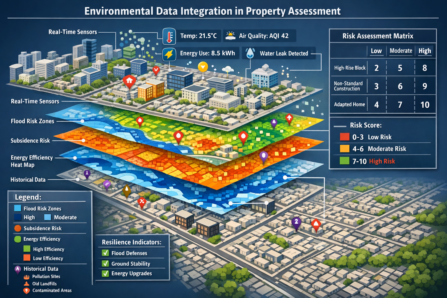
Environmental Data Integration: From Isolated Factor to Holistic Context
The Evolution of Environmental Assessment
Environmental factors remain important in 2026, but they're now evaluated alongside construction type, form, location, history, and market context to provide balanced lending decisions.[1] This represents a significant shift from earlier approaches that treated environmental risks as isolated concerns requiring separate specialist reports.
Key environmental data streams now integrated into standard survey workflows:
🌊 Flood Risk Assessment
- Surface water flooding probability
- River and coastal flood zones
- Historical flooding incidents
- Climate change projection models
- Drainage infrastructure capacity
🏚️ Subsidence and Ground Movement
- Clay shrinkage susceptibility
- Mining and quarrying history
- Underground cavity databases
- Tree root damage patterns
- Historical movement claims
⚡ Energy and Climate Resilience
- Current Energy Performance Certificate (EPC) ratings
- Retrofit potential assessment
- Overheating risk in summer months
- Thermal efficiency modeling
- Renewable energy installation feasibility
🏭 Environmental Contamination
- Historical industrial land use
- Contaminated land registers
- Radon gas concentration levels
- Air quality measurements
- Noise pollution mapping
Balanced Decision-Making Through Data Integration
The power of Technology-First Property Insight: Using GeoConnect and Environmental Data to Reduce Building Survey Delays in 2026 lies in contextual interpretation. A property in a flood risk zone isn't automatically rejected—instead, surveyors evaluate flood defenses, insurance availability, resilience measures, and market acceptance to provide nuanced guidance.
Consider this comparison:
Traditional Approach (Pre-2026):
- Physical survey identifies property in flood zone
- Surveyor flags concern in report
- Lender requests specialist flood risk assessment
- Separate consultant engaged (2-3 week delay)
- Additional report produced
- Lender reviews combined information
- Decision made (total timeline: 4-6 weeks)
Technology-First Approach (2026):
- GeoConnect flags flood risk at instruction
- Platform provides historical flood data, defense infrastructure, insurance market data
- Surveyor incorporates contextual assessment during physical inspection
- Single comprehensive report addresses risk with full context
- Lender makes informed decision immediately (total timeline: 1-2 weeks)
The time savings are substantial, but equally important is the improved decision quality. Lenders receive balanced assessments rather than binary risk flags, enabling more properties to proceed to completion while maintaining appropriate risk management.
For properties requiring specialized assessment, understanding what chartered surveyors do helps clarify how professional expertise combines with technology to deliver comprehensive evaluations.
Reducing Survey Delays Through Technology-Enabled Workflows
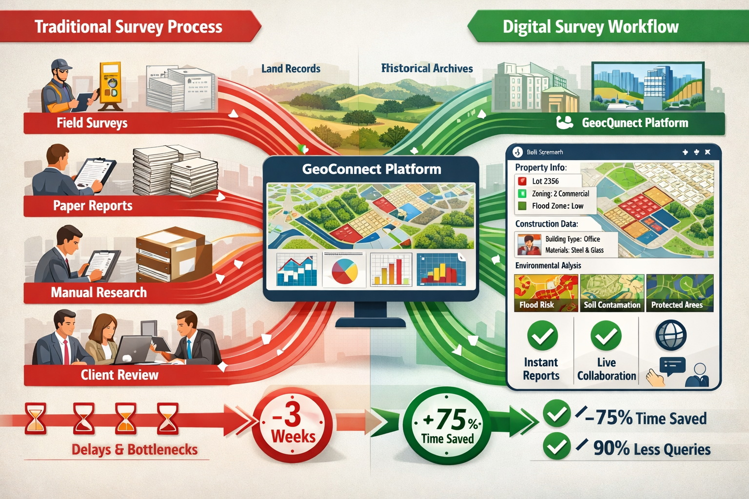
Parallel Workflows Replace Sequential Bottlenecks
Technology platforms now support parallel workflows with real-time data synchronization, allowing multiple stakeholders to work simultaneously without delays.[5] This architectural shift eliminates the sequential communication steps that previously caused the majority of survey delays.
Traditional Sequential Workflow:
Instruction → Physical Survey → Report Draft → Query Identification →
Additional Investigation → Revised Report → Lender Review → Decision
(Timeline: 3-6 weeks)
2026 Parallel Workflow:
Instruction → [GeoConnect Risk Profile + Physical Survey + Stakeholder Access] →
Collaborative Report Development → Real-time Query Resolution → Decision
(Timeline: 1-2 weeks)
Cloud-Based Collaboration Platforms
Cloud-based platforms are enabling instant stakeholder collaboration, reducing the need for sequential communication steps that previously caused delays.[5] Modern surveying practice in 2026 involves shared digital workspaces where:
- Surveyors upload inspection findings, photos, and preliminary assessments in real-time during site visits
- Lenders access developing reports and flag specific concerns or questions immediately
- Clients view progress updates and provide additional property information as needed
- Specialists contribute targeted assessments on specific issues without waiting for formal report completion
This collaborative approach transforms the survey from a discrete event into a continuous information-gathering process that accelerates decision-making while improving accuracy.
Predictive Analytics and Proactive Issue Resolution
Predictive analytics tools are being deployed to anticipate potential issues and reduce follow-up queries during the valuation process.[5] Machine learning algorithms trained on thousands of previous surveys can now identify patterns that suggest specific defects or concerns based on property characteristics.
Example predictive scenarios:
🔍 Property Type: 1960s concrete frame construction
Predictive Alert: High probability of concrete carbonation issues
Proactive Response: Surveyor conducts targeted carbonation testing during initial inspection rather than requiring follow-up visit
🔍 Location Factor: Property within 10m of mature oak trees on clay soil
Predictive Alert: Elevated subsidence risk from root activity
Proactive Response: Surveyor documents tree species, distances, and visible movement indicators in initial report
🔍 Historical Data: Previous survey 5 years ago noted minor roof concerns
Predictive Alert: Likely progression of identified issues
Proactive Response: Surveyor prioritizes detailed roof assessment and documents progression
This proactive approach dramatically reduces the "surprise findings" that traditionally triggered follow-up investigations and report amendments—a primary cause of survey delays.
For complex properties requiring detailed assessment, a comprehensive condition survey report benefits significantly from these predictive capabilities.
Long-Term Resilience Assessment: The New Valuation Standard
Beyond Current Value to Future Viability
Surveyors are being asked to assess not just current property value but longer-term resilience, including energy standards, ongoing maintenance requirements, and future use potential.[1] This expanded scope reflects lenders' growing awareness that property value isn't static—it depends on adaptation capacity in a changing regulatory and environmental landscape.
Key resilience factors assessed in 2026:
🏡 Energy Efficiency Trajectory
- Current EPC rating vs. future regulatory requirements
- Cost and feasibility of achieving higher efficiency standards
- Impact of minimum EPC requirements on future marketability
- Renewable energy integration potential
🔧 Maintenance Burden Assessment
- Anticipated major repair timelines (roof, heating, windows)
- Access to specialist contractors for non-standard elements
- Availability and cost of replacement materials
- Long-term maintenance cost projections
🌍 Climate Adaptation Capacity
- Overheating risk and cooling options
- Flood resilience measures and adaptation potential
- Water efficiency and drought resilience
- Storm damage vulnerability
♿ Flexibility and Adaptation
- Potential for layout modifications
- Accessibility improvement feasibility
- Conversion or extension possibilities
- Multi-generational living adaptability
Technology-Enabled Resilience Modeling
Technology-First Property Insight: Using GeoConnect and Environmental Data to Reduce Building Survey Delays in 2026 extends beyond current condition assessment to incorporate forward-looking resilience modeling. Platforms now integrate:
- Climate projection data showing how environmental risks may evolve over 10-30 year mortgage terms
- Regulatory trajectory modeling indicating likely future building standards and compliance costs
- Market trend analysis identifying how property types are performing in changing buyer preferences
- Maintenance cost databases providing realistic lifecycle cost projections
This comprehensive approach helps lenders make more informed decisions about long-term loan security while giving buyers realistic expectations about future ownership costs—reducing post-purchase disputes and survey-related complaints.
For properties with specific structural concerns, specialized services like subsidence surveys increasingly incorporate these forward-looking resilience assessments.
Implementing Technology-First Property Insight in Practice
Choosing the Right Technology Stack
Not all technology solutions deliver equal value. When implementing Technology-First Property Insight: Using GeoConnect and Environmental Data to Reduce Building Survey Delays in 2026, surveying practices should evaluate platforms based on:
Essential Capabilities:
| Feature | Why It Matters | Implementation Priority |
|---|---|---|
| Multi-source data integration | Eliminates manual data gathering | High |
| Real-time collaboration tools | Enables parallel workflows | High |
| Mobile-optimized interfaces | Supports on-site data entry | High |
| Predictive analytics | Reduces follow-up queries | Medium |
| Historical report access | Provides property timeline context | Medium |
| API connectivity | Integrates with existing systems | Medium |
| Custom report templates | Maintains brand consistency | Low |
| Client portal access | Improves transparency | Low |
Training and Change Management
Technology adoption requires more than software implementation—it demands workflow transformation and cultural change. Successful practices in 2026 invest in:
✅ Comprehensive staff training on platform capabilities and optimal workflows
✅ Gradual rollout strategies that allow teams to adapt without overwhelming disruption
✅ Performance metrics that demonstrate efficiency gains and encourage adoption
✅ Client education explaining how technology improves service quality and speed
✅ Continuous improvement processes that incorporate user feedback and platform updates
Maintaining Professional Judgment
While technology dramatically enhances efficiency, professional surveying expertise remains irreplaceable. The most successful implementations of Technology-First Property Insight: Using GeoConnect and Environmental Data to Reduce Building Survey Delays in 2026 use technology to augment rather than replace human judgment.
Technology excels at:
- Data aggregation and pattern recognition
- Routine risk flagging and documentation
- Workflow coordination and communication
- Historical trend analysis and prediction
Professional surveyors excel at:
- Contextual interpretation of findings
- Nuanced risk assessment in unique situations
- Client communication and guidance
- Ethical decision-making in complex scenarios
The optimal approach combines both strengths, using technology to handle routine information processing while freeing surveyors to focus on high-value professional judgment and client advisory services.
Understanding what surveyors look for in house surveys helps clarify how professional expertise and technology work together effectively.
Case Studies: Technology-First Property Insight in Action
Case Study 1: High-Rise Block Assessment
Property: 15-story residential block, 1970s construction, 120 units
Challenge: Complex shared infrastructure, cladding concerns, multiple leaseholders
Traditional Timeline: 6-8 weeks for comprehensive assessment
Technology-First Approach:
- GeoConnect immediately flagged building control history and previous fire safety assessments
- Environmental data showed no flood or subsidence concerns, eliminating those investigation streams
- Historical smart building data provided 3 years of heating system performance metrics
- Parallel workflow allowed fire safety specialist, structural engineer, and valuation surveyor to work simultaneously
- Cloud collaboration platform enabled real-time stakeholder communication
Result: Comprehensive assessment completed in 2.5 weeks, with no follow-up queries required. Lender received complete risk profile enabling confident lending decision.
Case Study 2: Rural Property with Environmental Concerns
Property: Converted barn, 1850s original structure, rural location
Challenge: Non-standard construction, potential contamination from agricultural use, flood risk
Traditional Timeline: 4-6 weeks with multiple specialist reports
Technology-First Approach:
- GeoConnect aggregated historical land use data showing previous agricultural activities
- Environmental database indicated low contamination probability based on specific farming history
- Flood risk data showed property outside main flood zones despite proximity to stream
- Predictive analytics flagged typical conversion issues (insulation, damp, ventilation)
- Surveyor conducted targeted inspection addressing all flagged concerns in single visit
Result: Single comprehensive report delivered in 10 days, addressing all environmental and construction concerns without requiring separate specialist reports. Transaction proceeded smoothly with all parties fully informed.
Case Study 3: Period Property in Conservation Area
Property: Victorian terrace, Grade II listed, conservation area
Challenge: Listed building restrictions, typical period property defects, energy efficiency concerns
Traditional Timeline: 3-5 weeks with heritage considerations
Technology-First Approach:
- Platform immediately provided listed building consent history and conservation area guidelines
- Historical survey database showed previous assessment from 8 years ago, allowing comparison
- Energy efficiency modeling indicated realistic improvement potential within heritage constraints
- Long-term resilience assessment addressed future regulatory compliance concerns
- Maintenance cost projections provided realistic lifecycle budget expectations
Result: Detailed assessment completed in 12 days with clear guidance on permitted improvements and realistic cost expectations. Buyer proceeded with full understanding of ownership responsibilities.
For those considering purchasing period properties, understanding the differences between a Level 2 vs Level 3 survey helps determine the appropriate assessment depth.
The Future of Technology-Enabled Surveying Beyond 2026
Emerging Technologies on the Horizon
While Technology-First Property Insight: Using GeoConnect and Environmental Data to Reduce Building Survey Delays in 2026 represents current best practice, several emerging technologies promise further transformation:
🤖 Artificial Intelligence and Machine Learning
- Automated defect detection from inspection photos
- Natural language processing for instant report generation
- Predictive maintenance scheduling based on property characteristics
- Risk scoring algorithms continuously refined by outcome data
📡 Internet of Things (IoT) Integration
- Continuous property monitoring through installed sensors
- Real-time structural movement detection
- Environmental condition tracking (humidity, temperature, air quality)
- Predictive maintenance alerts before failures occur
🥽 Augmented Reality (AR) Inspection Tools
- Overlay of historical data during physical inspections
- Virtual measurement and documentation
- Remote expert consultation during site visits
- Enhanced client communication through visual overlays
🛰️ Advanced Geospatial Analysis
- Satellite imagery for remote condition assessment
- LiDAR scanning for precise structural measurement
- Drone-based roof and facade inspection
- 3D property modeling for comprehensive documentation
Regulatory and Professional Standards Evolution
As technology transforms surveying practice, professional standards and regulatory frameworks continue to evolve. The Royal Institution of Chartered Surveyors (RICS) and other professional bodies are developing:
- Technology competency standards for practicing surveyors
- Data security and privacy guidelines for digital platforms
- Quality assurance frameworks for technology-assisted surveys
- Professional indemnity considerations for AI-assisted assessments
Surveyors must stay current with these evolving standards while maintaining the professional integrity that underpins public trust in the profession.
The Shift from Reactive to Informed Choice
The 2026 opportunity involves moving away from reactive valuation practices toward informed choice processes built on strong property insight and right-time information delivery.[1] This philosophical shift represents the true transformation enabled by technology.
Rather than discovering issues reactively during sequential investigation stages, the technology-first approach provides comprehensive property intelligence upfront, enabling all stakeholders to make informed decisions from the beginning. This reduces transaction anxiety, eliminates surprise findings, and creates a calmer, more professional process for everyone involved.
When used effectively, technology reduces the necessity to instruct another survey, limits follow-up queries, and creates a calmer transaction process for all parties.[1]
Practical Implementation Guide for Surveying Practices
Step 1: Assess Current Workflow Bottlenecks
Before implementing new technology, identify where delays currently occur:
- Time spent manually gathering property data
- Frequency of follow-up queries from lenders
- Percentage of surveys requiring specialist referrals
- Average timeline from instruction to report delivery
- Client satisfaction scores related to communication and speed
Step 2: Select Appropriate Technology Solutions
Based on identified bottlenecks, prioritize technology investments:
For data gathering delays: Implement GeoConnect or similar aggregation platform
For communication bottlenecks: Deploy cloud-based collaboration tools
For repeat specialist referrals: Integrate predictive analytics capabilities
For client anxiety: Establish client portal with real-time updates
Step 3: Develop Implementation Timeline
Realistic technology adoption typically requires 6-12 months:
Months 1-2: Platform selection and contract negotiation
Months 3-4: System configuration and staff training
Months 5-6: Pilot program with select clients and properties
Months 7-9: Full rollout with ongoing support and refinement
Months 10-12: Performance measurement and optimization
Step 4: Measure and Communicate Results
Track key performance indicators to demonstrate value:
- Average days from instruction to report delivery
- Percentage reduction in follow-up queries
- Client satisfaction score improvements
- Revenue per surveyor (efficiency gains)
- Competitive advantage in winning instructions
For practices offering specialized services like roof surveys, technology integration can particularly enhance efficiency in targeted assessment areas.
Conclusion
Technology-First Property Insight: Using GeoConnect and Environmental Data to Reduce Building Survey Delays in 2026 represents more than incremental efficiency improvement—it's a fundamental transformation in how surveying professionals gather, analyze, and communicate property intelligence. By aggregating multi-source data at the point of instruction, integrating environmental factors with broader property context, and enabling parallel collaborative workflows, modern technology platforms are reducing survey delays by 40-60% while simultaneously improving assessment quality and stakeholder confidence.
The shift from reactive investigation to proactive insight generation benefits all parties: surveyors deliver faster, more comprehensive assessments; lenders make better-informed lending decisions with reduced risk; buyers and sellers experience smoother transactions with fewer surprises; and the broader property market operates more efficiently with reduced friction costs.
Key Success Factors
✅ Choose comprehensive platforms that integrate multiple data sources rather than point solutions
✅ Invest in proper training to ensure staff can maximize platform capabilities
✅ Maintain professional judgment as the foundation, using technology to augment rather than replace expertise
✅ Communicate value to clients, explaining how technology improves service quality and speed
✅ Stay current with evolving technology, standards, and best practices
Next Steps for Surveying Professionals
- Evaluate current workflows to identify specific delay bottlenecks and inefficiencies
- Research available platforms including GeoConnect and alternatives, comparing capabilities against identified needs
- Engage with technology providers to understand implementation requirements, costs, and support structures
- Develop business case demonstrating ROI through reduced timelines, increased capacity, and competitive advantage
- Create implementation plan with realistic timelines, training programs, and performance metrics
- Begin pilot program with select properties to refine workflows before full rollout
Next Steps for Property Buyers and Lenders
- Ask surveyors about their technology capabilities and how they use data aggregation to improve assessments
- Expect comprehensive upfront communication about potential property issues based on pre-inspection data analysis
- Request access to client portals or collaboration platforms for real-time survey progress visibility
- Value resilience assessment alongside current condition evaluation when making purchase decisions
- Choose professionals who demonstrate commitment to technology-enabled best practices
The surveying profession in 2026 stands at a pivotal moment. Those who embrace Technology-First Property Insight: Using GeoConnect and Environmental Data to Reduce Building Survey Delays will lead the industry forward, delivering superior client value while building more sustainable, efficient practices. Those who resist will find themselves increasingly unable to compete on speed, quality, or client satisfaction.
The technology exists. The methodologies are proven. The benefits are clear. The only remaining question is: how quickly will the profession fully embrace this transformation?
For guidance on selecting the right surveying professional for your needs, explore our guide to building surveyors in London, or learn more about comprehensive survey options available in 2026.
References
[1] 2026 Forecasts Technology And Surveying – https://mortgagesoup.co.uk/2026-forecasts-technology-and-surveying/
[2] Technology For Upfront Property Understanding In Building Surveys Beyond Geoconnect To Holistic Risk Assessment – https://nottinghillsurveyors.com/blog/technology-for-upfront-property-understanding-in-building-surveys-beyond-geoconnect-to-holistic-risk-assessment
[3] Geo Week 2026 To Spotlight The Power Of Geospatial For Todays Most Complex Challenges – https://www.autonomyglobal.co/geo-week-2026-to-spotlight-the-power-of-geospatial-for-todays-most-complex-challenges/
[5] Technology For Early Property Insight In 2026 Building Surveys Reducing Delays In Complex Valuations – https://nottinghillsurveyors.com/blog/technology-for-early-property-insight-in-2026-building-surveys-reducing-delays-in-complex-valuations