
Over 40% of party wall disputes in dense urban environments stem from inaccurate pre-construction condition records — a problem that 3D laser scanning is rapidly eliminating. As London and other major cities push development deeper underground and closer to neighbouring boundaries, the margin for measurement error has shrunk to near zero. 3D Laser Scanning in Party Wall Surveys: Enhancing Accuracy for Deep Excavations and Boundary Works in 2026 Urban Projects is no longer a luxury reserved for mega-developments — it is becoming the professional standard for any project where a millimetre of uncertainty can translate into thousands of pounds of litigation.
This article explores how modern scanning technology integrates with the party wall process, why RICS-aligned surveyors are adopting it for award defensibility, and what building owners and developers need to know before breaking ground in 2026.
Key Takeaways 📌
- 3D laser scanners capture up to one million points per second, producing millimetre-accurate point clouds that serve as irrefutable pre-construction evidence [2]
- Deep basement excavations and boundary works carry the highest dispute risk — precise as-built models dramatically reduce neighbour conflicts
- BIM integration allows scan data to feed directly into structural calculations, party wall awards, and legal documentation
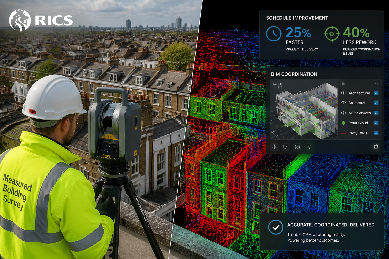
- Cost savings from scan-assisted construction monitoring include 8–15% cost reductions and a 40% drop in rework incidents [2]
- RICS-compliant surveyors are increasingly embedding scan data into Schedule of Condition reports to make party wall awards legally robust
How 3D Laser Scanning Works in the Context of Party Wall Surveys
The Technology Behind the Point Cloud
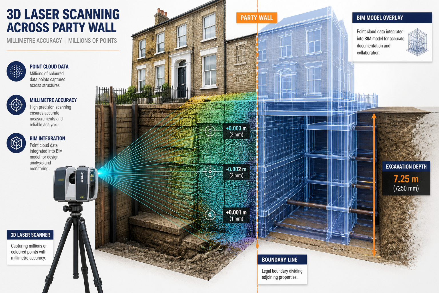
Modern terrestrial laser scanners — such as the Leica BLK360 and the Trimble X9 — emit millions of laser pulses per second, each one bouncing back to the instrument and recording an exact X, Y, Z coordinate in three-dimensional space [2]. The result is a point cloud: a dense digital replica of every surface the scanner can see, accurate to within 1–3 millimetres at typical survey distances.
For party wall purposes, this means a surveyor can capture:
- The precise position of a shared wall relative to the legal boundary
- Any existing cracks, bulges, or deformations before work begins
- The exact geometry of foundations, floor slabs, and structural elements
- Neighbouring property facades, garden walls, and outbuildings
This data is then processed into as-built BIM (Building Information Modelling) models, georeferenced to Ordnance Survey coordinates, and archived as a timestamped legal record.
Why Traditional Methods Fall Short
Conventional Schedule of Condition surveys rely on photographs, hand measurements, and written descriptions. While legally valid, they have clear limitations:
| Method | Accuracy | Coverage | Dispute Resistance |
|---|---|---|---|
| Photographs | Low | Partial | Moderate |
| Hand measurements | ±5–20mm | Selective | Low–Moderate |
| 3D laser scan | ±1–3mm | Comprehensive | High |
| BIM model from scan | ±1–3mm | Full as-built | Very High |
When a neighbour claims that a crack in their wall was caused by excavation works, a photograph taken months earlier may be ambiguous. A georeferenced point cloud from the same date is not — it shows the exact crack width, position, and depth, and can be compared directly to a post-construction scan to quantify any change.
For a thorough grounding in the legal framework that governs these surveys, the complete guide to party wall surveys for homeowners provides an excellent starting point.
Deep Excavations and Boundary Works: Where Accuracy Is Non-Negotiable
The High-Stakes Nature of Urban Basement Projects
London's housing stock is increasingly being extended downward. Basement conversions, underpinning schemes, and new sub-structure works routinely bring excavations to 3–6 metres below ground level, directly adjacent to neighbouring foundations that may be 100 years old or more. Under the Party Wall etc. Act 1996, any excavation within 3 metres of a neighbouring structure (or within 6 metres if the excavation goes deeper than the neighbour's foundations) requires formal notice and, in most cases, a party wall award.
The party wall excavation notice process is a critical legal step — but serving notice is only the beginning. The award itself must be defensible, and that defensibility rests heavily on the quality of the pre-construction condition record.
What Can Go Wrong Without Scan Data
Consider a typical scenario: a developer excavates a new basement in a Victorian terrace. Three months later, the adjoining owner reports cracking to their rear extension. Without a high-resolution pre-construction scan, the dispute becomes a "he said, she said" argument between two sets of experts. With a scan:
- Pre-existing cracks are documented to the millimetre
- Wall plumb and alignment are recorded, showing whether any lean pre-dates the works
- Floor slab settlement can be tracked against baseline measurements
- Boundary positions are confirmed to sub-centimetre accuracy, preventing encroachment claims
This is precisely why 3D Laser Scanning in Party Wall Surveys: Enhancing Accuracy for Deep Excavations and Boundary Works in 2026 Urban Projects has become a cornerstone of best practice for any project involving significant ground works near shared boundaries.
Monitoring Surveys: Scanning Throughout the Build
Static pre-construction scans are valuable, but periodic monitoring scans taken during excavation and construction phases add another layer of protection. By comparing successive point clouds, surveyors can detect:
- Incremental wall movement exceeding agreed trigger levels
- Foundation settlement developing in real time
- Any deviation from the approved method statement
💡 Pull Quote: "A point cloud taken every two weeks during excavation is worth more than any post-incident expert report — it shows exactly when movement began and how fast it progressed."
Construction progress monitoring with 3D scanning has been shown to achieve 8–15% cost savings, 25% schedule improvements, and a 40% reduction in rework incidents across commercial projects [2]. For monitoring surveys on party wall projects, the same principles apply at a neighbourhood scale.
RICS Integration, BIM Workflows, and Award Defensibility
Embedding Scan Data into the Party Wall Award
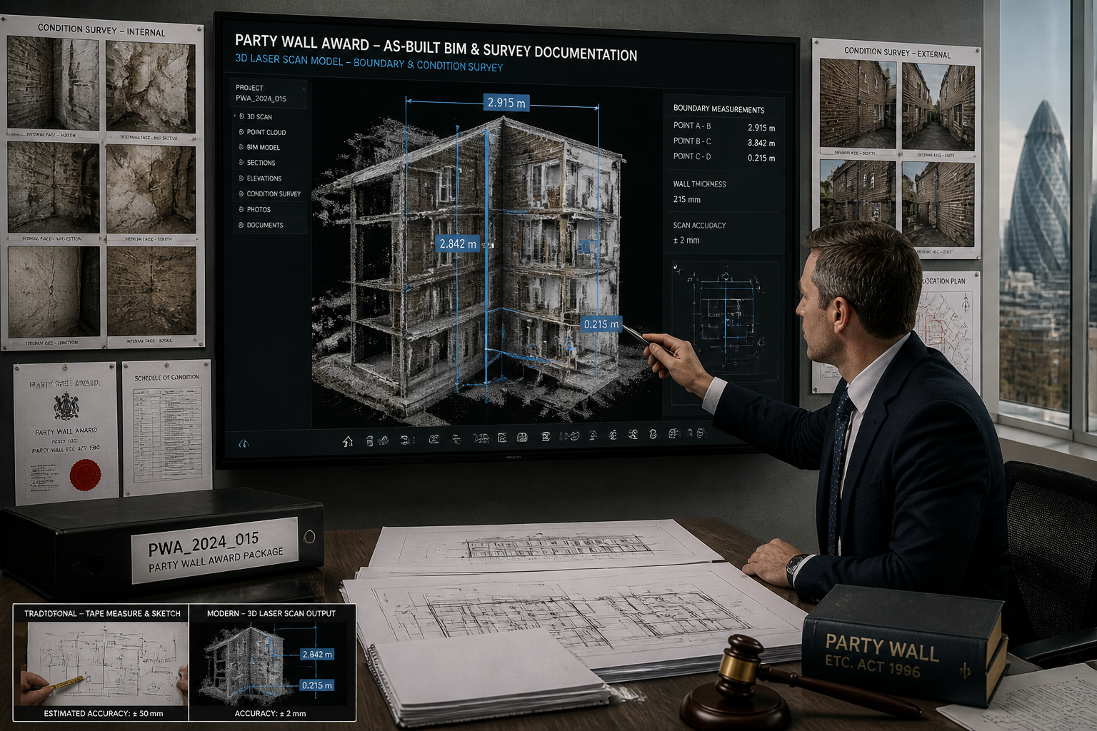
A party wall award is a legally binding document that sets out the rights and obligations of both the building owner and the adjoining owner. Its strength as a legal instrument depends on the quality of the evidence it incorporates. RICS guidance increasingly supports the use of digital survey data — including point clouds and BIM models — as part of Schedule of Condition appendices.
The workflow typically follows these steps:
- Pre-notice scan — Capture full condition of adjoining property and shared structures
- Point cloud processing — Convert raw scan data into a registered, georeferenced model
- BIM model creation — Build an as-built model for integration with structural drawings
- Award preparation — Embed scan-derived measurements and condition records into the award document
- Monitoring protocol — Define trigger levels and scanning intervals during construction
- Post-construction scan — Compare against baseline to identify and quantify any damage
For those navigating the formal process, the step-by-step guide to the party wall process explains how each stage connects to legal obligations under the 1996 Act.
How BIM Strengthens the Legal Record
Building Information Modelling transforms a static point cloud into an intelligent, queryable model. Structural engineers can extract:
- Exact wall thicknesses and material properties
- Foundation depths relative to proposed excavation levels
- Load paths and potential stress concentrations
When this model is linked to the party wall award, it creates a digital chain of evidence that is extremely difficult to challenge in dispute proceedings. If a claim does arise, the party wall award guidance resource explains how awards are interpreted and enforced — and why robust technical evidence makes all the difference.
The Role of the Party Wall Surveyor in a Scan-Assisted Project
Not all party wall surveyors are yet equipped to commission or interpret 3D scan data. In 2026, the most effective approach is a collaborative team:
- Party wall surveyor — Legal framework, notice service, award drafting
- 3D scanning specialist — Data capture, point cloud processing, BIM modelling
- Structural engineer — Interpretation of scan data relative to proposed works
Understanding the roles and responsibilities of party wall surveyors helps building owners assemble the right team from the outset.
Costs, Practicalities, and Choosing the Right Approach
What Does 3D Scanning Cost for Party Wall Projects?
Scanning costs vary significantly based on project size, complexity, and the level of BIM deliverable required. For commercial and residential projects, typical ranges are [1]:
| Project Type | Scan Cost Range | Per Sq Ft Rate |
|---|---|---|
| Small residential | £800–£2,500 | £0.15–£0.40 |
| Medium residential/mixed | £2,500–£8,000 | £0.20–£0.55 |
| Large commercial | £8,000–£15,000+ | £0.20–£0.70 |
These costs should be weighed against the potential cost of a party wall dispute, which can easily reach £10,000–£50,000 in surveyor fees, legal costs, and remediation works. The damage to property in party wall resource illustrates the financial consequences of inadequate pre-construction records.
Practical Considerations for Urban Sites
Urban scanning comes with specific challenges:
- Access restrictions — Scanning must often be completed from public highways or with neighbour cooperation
- Vibration and traffic — Dense urban environments can introduce noise into scan data; experienced operators mitigate this through multiple scan positions and registration techniques
- Occupied buildings — Internal scans of adjoining properties require the adjoining owner's consent, which the party wall process facilitates
- Data management — Point clouds for a typical terrace project can run to 50–200 GB; robust data management protocols are essential
The 2026 Market Context 🔍
The industrial 3D scanner market is expanding rapidly, with increased competition driving down hardware costs and improving software accessibility [6]. Scan-to-BIM workflows that once required specialist bureaux can now be executed by well-equipped surveying practices in-house. This democratisation of technology means that 3D Laser Scanning in Party Wall Surveys: Enhancing Accuracy for Deep Excavations and Boundary Works in 2026 Urban Projects is accessible to projects of all scales — not just major commercial developments.
For those wanting to understand the broader landscape of survey technology available in 2026, the 2026 land survey equipment overview provides useful context on how total stations, GPS, and laser scanners compare.
Reducing Disputes Through Better Evidence
The Dispute Prevention Dividend
The most compelling argument for scan-assisted party wall surveys is not technical — it is financial and relational. Neighbours who might otherwise dispute the cause of post-construction cracking are far less likely to do so when presented with a timestamped, millimetre-accurate record showing that the crack existed before works began.
Key dispute triggers that scanning directly addresses:
- ✅ Pre-existing damage attribution — Eliminated by baseline scan records
- ✅ Boundary encroachment claims — Resolved by georeferenced boundary mapping
- ✅ Settlement quantification — Measured objectively by comparing pre and post scans
- ✅ Method statement compliance — Verified by monitoring scan comparisons
For situations where disputes do arise despite best efforts, the comprehensive guide to resolving party wall disputes outlines the resolution pathways available under the 1996 Act.
Scan Data as Expert Evidence
In the event that a party wall matter reaches the Third Surveyor or the courts, point cloud data and BIM models are increasingly accepted as expert evidence. The objectivity of scan data — captured by instruments with documented calibration records — carries significant weight compared to subjective photographic interpretation. Autodesk's research into laser scanning in construction confirms that digital capture fundamentally changes the evidentiary landscape for construction disputes [4].
Conclusion: Actionable Next Steps for 2026 Urban Projects
3D Laser Scanning in Party Wall Surveys: Enhancing Accuracy for Deep Excavations and Boundary Works in 2026 Urban Projects represents the convergence of legal rigour and technological capability. For any project involving deep excavations, underpinning, or works close to shared boundaries in 2026, the following steps are recommended:
-
Engage a party wall surveyor early — Before any design is finalised, understand which neighbours require notice and what the award will need to cover. The party wall FAQ is a useful first reference.
-
Commission a pre-construction 3D scan — Ensure the scan covers all adjoining structures within the zone of influence, both externally and (with consent) internally.
-
Integrate scan data into the party wall award — Work with a surveyor who understands BIM workflows and can embed georeferenced condition records into the legal documentation.
-
Establish a monitoring protocol — Define trigger levels for wall movement and schedule regular monitoring scans throughout the construction programme.
-
Retain all scan data post-completion — Point cloud archives should be stored for a minimum of 12 years, aligned with limitation periods for latent defect claims.
-
Compare pre and post-construction scans — A final scan at practical completion provides a definitive record of any changes attributable to the works, closing the evidentiary loop.
The combination of precise digital evidence and a well-drafted party wall award is the most effective risk management tool available to developers, building owners, and their professional advisors in 2026's complex urban environment.
References
[1] 3D Scanning Cost Guide – https://www.thefuture3d.com/learn/3d-scanning-cost-guide/
[2] Construction Progress Monitoring 3D Scanning Complete Guide – https://iscano.com/real-world-applications-laser-scanning-lidar/construction-progress-monitoring-3d-scanning-complete-guide/
[3] High Accuracy 3D Laser Scanning of Houses for Property Evaluation – https://scanm2.com/post/high-accuracy-3d-laser-scanning-of-houses-for-property-evaluation/
[4] Laser Scanning in Construction – https://www.autodesk.com/blogs/construction/laser-scanning-in-construction/
[5] Navigating the 2026 Land Survey Equipment Boom: Total Stations, GPS and Laser Scanners Reviewed – https://nottinghillsurveyors.com/blog/navigating-the-2026-land-survey-equipment-boom-total-stations-gps-and-laser-scanners-reviewed
[6] 2026 Industrial 3D Scanner Market Insights: Moving Beyond – https://www.openpr.com/news/4480677/2026-industrial-3d-scanner-market-insights-moving-beyond