
The land surveying industry stands at a pivotal moment in 2026. With global infrastructure investment reaching unprecedented levels and urbanization accelerating across emerging economies, the demand for precision surveying equipment has exploded into a multi-billion-dollar market. Navigating the 2026 Land Survey Equipment Boom: Total Stations, GPS, and Laser Scanners Reviewed reveals how surveying professionals can leverage cutting-edge technology to meet the challenges of modern construction, mining, and renewable energy projects. The market has surged to approximately $9.22–$10.72 billion in 2026, with projections indicating continued expansion to $14.96–$15.21 billion by 2032–2034[1][3][8]. This remarkable growth trajectory reflects not just increased demand, but a fundamental transformation in how surveying work gets done.
For chartered surveyors and construction professionals, understanding the equipment landscape has become essential to maintaining competitive advantage. Whether working on urban development projects in Central London or infrastructure expansion in Hertfordshire, selecting the right surveying technology directly impacts project accuracy, timeline, and profitability.
Key Takeaways
📊 Market Growth: The global land survey equipment market reached $9.22–$10.72 billion in 2026, driven by infrastructure development, urbanization in Asia and Africa, and renewable energy investments[1][3][8].
🎯 Total Stations Lead: Total stations command 33.80% of market revenue, with robotic models doubling single-operator productivity by eliminating the need for a second surveyor[2][3].
🛰️ GPS/GNSS Fastest Growth: Multi-frequency GNSS systems represent the fastest-growing technology segment at 30.24% market share, providing real-time positioning in challenging field conditions[1].
✈️ UAV-LiDAR Expansion: Drone-based LiDAR platforms are growing at 21.2% CAGR, reaching 12.80% market share for large-area mapping applications[3].
💡 Service Models Evolving: Hardware-as-a-Service subscriptions are transforming equipment acquisition, bundling leasing with cloud analytics to reduce upfront costs[3].
Understanding the 2026 Land Survey Equipment Market Landscape
Market Size and Growth Drivers
The land surveying equipment sector has experienced remarkable expansion, with market valuations varying between $9.22 billion and $10.72 billion in 2026 depending on analyst methodology and baseline assumptions[1][3][8]. This growth represents a compound annual growth rate of 5.6–6.3%, reflecting robust demand across multiple industry verticals[1][2][8].
Several key factors fuel this expansion:
Infrastructure Development: Governments worldwide have committed unprecedented resources to infrastructure modernization. Transportation networks, utility systems, and smart city initiatives all require extensive surveying work to ensure precision in planning and execution[4].
Urbanization in Emerging Markets: Rapid urban expansion in Asia and Africa creates continuous demand for land surveying services. Cities in these regions require accurate boundary determination, topographic mapping, and construction layout services[4].
Mining Sector Growth: The global transition to renewable energy has increased demand for minerals like lithium, cobalt, and rare earth elements. Mining operations depend heavily on surveying equipment for exploration, extraction planning, and environmental monitoring[4].
Renewable Energy Projects: Wind farms, solar installations, and hydroelectric facilities require precise site surveys. The renewable energy boom has created a sustained pipeline of surveying projects[4].
Regional Market Dynamics
North America maintains market leadership with valuations of $3.89 billion in 2025 and $4.01 billion in 2026[1]. The United States specifically accounts for $2.96 billion in 2026, driven by defense applications, mining operations, and infrastructure renewal programs[1]. Major manufacturers including Hexagon AB, Trimble Inc., and Topcon Corporation maintain significant operations in this region[1].
The concentration of advanced manufacturing capabilities and early technology adoption gives North American firms a competitive edge in developing next-generation surveying solutions. However, emerging markets in Asia-Pacific show the fastest growth rates as construction activity intensifies.
Hardware Versus Services Balance
Hardware components account for 67.79% of total market value in 2026, underscoring the continued importance of physical instruments in surveying workflows[1]. Total stations, GPS receivers, and laser scanners represent substantial capital investments for surveying firms.
However, the market is simultaneously experiencing a paradigm shift toward Hardware-as-a-Service (HaaS) subscription models. Leading vendors like Trimble now bundle equipment leasing with cloud-based analytics platforms, enabling surveyors to access cutting-edge technology without large upfront capital expenditures[3]. This approach reduces operational expenses and minimizes project cash flow disruption.
Advanced equipment now features self-diagnostic capabilities that enable remote firmware updates and predictive maintenance, significantly reducing field downtime[3]. These service-oriented features represent a fundamental shift in how surveying businesses manage their equipment portfolios.
Total Stations: The Cornerstone of Modern Surveying
Market Position and Technology Evolution
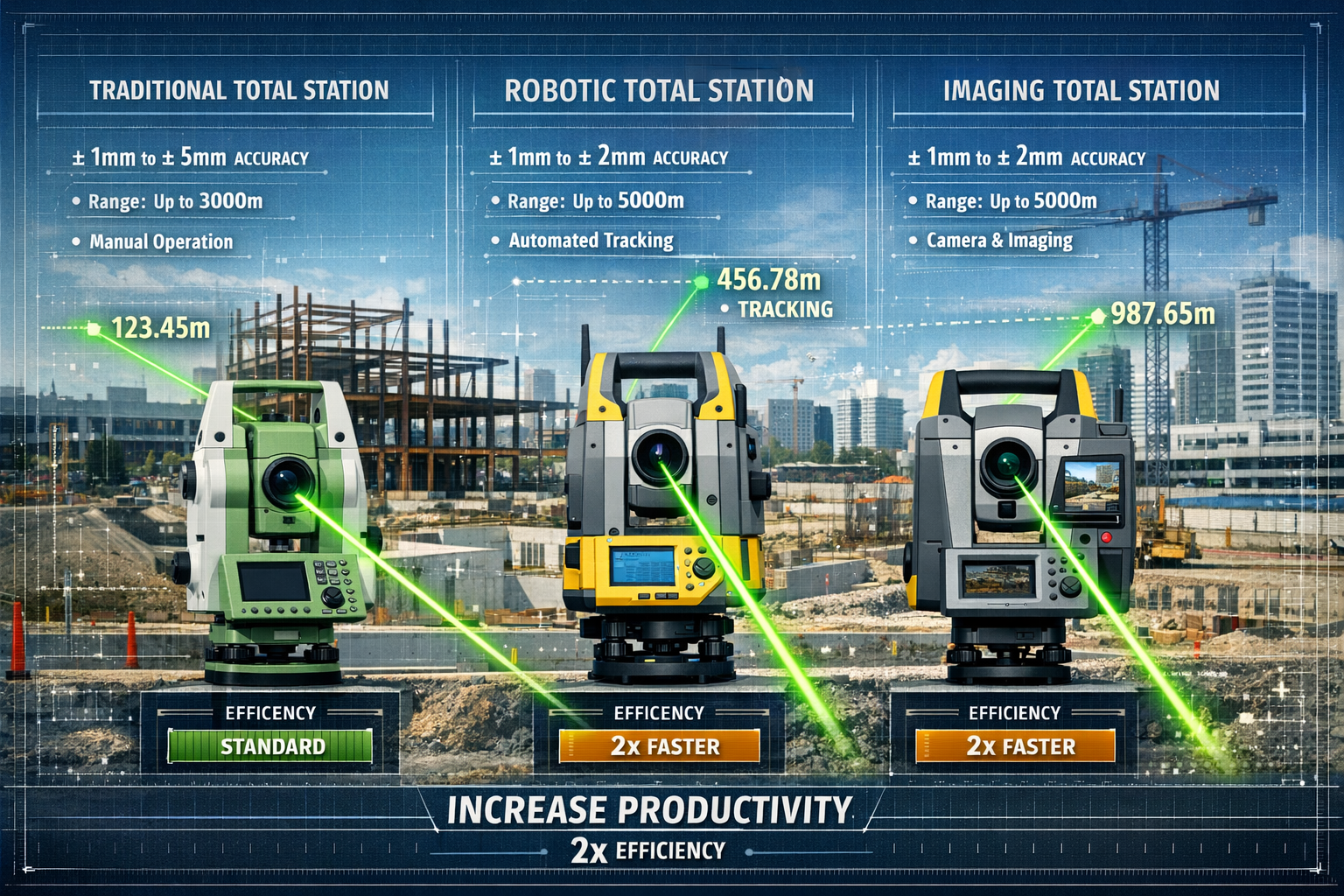
Total stations remain the largest equipment segment, commanding 33.80% of 2025 revenue[3]. These instruments have retained market dominance by continuously incorporating advanced automation features that dramatically improve surveying efficiency and accuracy.
Modern total stations integrate electronic distance measurement (EDM), angle measurement, and data processing into a single instrument. This integration eliminates the need for separate theodolites and distance meters, streamlining fieldwork and reducing equipment costs.
Robotic Total Stations: The Productivity Revolution
Robotic total stations represent the most significant advancement in surveying technology over the past decade. These automated systems fundamentally transform surveying workflows by enabling single-operator functionality[2].
Traditional total station surveys required two professionals: one operating the instrument and another holding the prism at measurement points. Robotic total stations eliminate this requirement through automated target tracking and remote control capabilities[2]. A single surveyor can now complete work that previously required two professionals, effectively doubling single-operator productivity[2].
Key features of robotic total stations include:
- Automated Target Tracking: The instrument automatically follows a prism as the surveyor moves around the site
- Remote Operation: Surveyors control the total station via handheld controller or tablet
- Automated Scanning: Built-in scanning capabilities capture detailed point clouds
- Imaging Sensors: Integrated cameras document site conditions and verify measurements
Accuracy Specifications and Applications
Modern total stations deliver exceptional precision across various measurement ranges:
| Accuracy Class | Angular Accuracy | Distance Accuracy | Typical Applications |
|---|---|---|---|
| High Precision | ±0.5" to ±1" | ±(1mm + 1ppm) | Control networks, deformation monitoring |
| Standard | ±2" to ±5" | ±(2mm + 2ppm) | Construction layout, topographic surveys |
| Construction Grade | ±5" to ±9" | ±(3mm + 2ppm) | Building construction, site development |
For construction surveys, standard accuracy total stations provide excellent value, delivering the precision needed for most building projects without the premium cost of high-precision instruments.
Imaging Total Stations: Documentation Meets Measurement
Imaging total stations incorporate high-resolution cameras that capture panoramic site images synchronized with measurement data. This capability provides several advantages:
✅ Visual Documentation: Photographs provide context for measurements and serve as legal documentation of site conditions
✅ Remote Site Inspection: Project managers can virtually inspect sites without traveling to the location
✅ Improved As-Built Verification: Comparing photographs with design models helps identify discrepancies
✅ Enhanced Safety: Surveyors can measure hazardous or inaccessible points using image-based targeting
Buying Considerations for Total Stations
When selecting a total station for urban expansion projects, consider these factors:
Range Requirements: Urban construction typically requires 300-1000m range, while infrastructure projects may need 3000-5000m capabilities.
Accuracy Needs: Match instrument precision to project tolerances. Over-specifying accuracy increases costs unnecessarily.
Automation Level: Robotic capabilities significantly increase productivity but command premium prices. Calculate ROI based on labor savings.
Environmental Durability: Construction sites demand rugged instruments with IP65 or IP66 ratings for dust and water resistance.
Data Integration: Ensure compatibility with existing CAD software, data collectors, and project management systems.
Manufacturer Support: Consider local service availability, calibration services, and technical support quality.
For surveyors working across North London and surrounding areas, choosing equipment with strong regional support networks ensures minimal downtime when service is needed.
GPS and GNSS Systems: Positioning Technology for the Modern Era
The Fastest-Growing Technology Segment
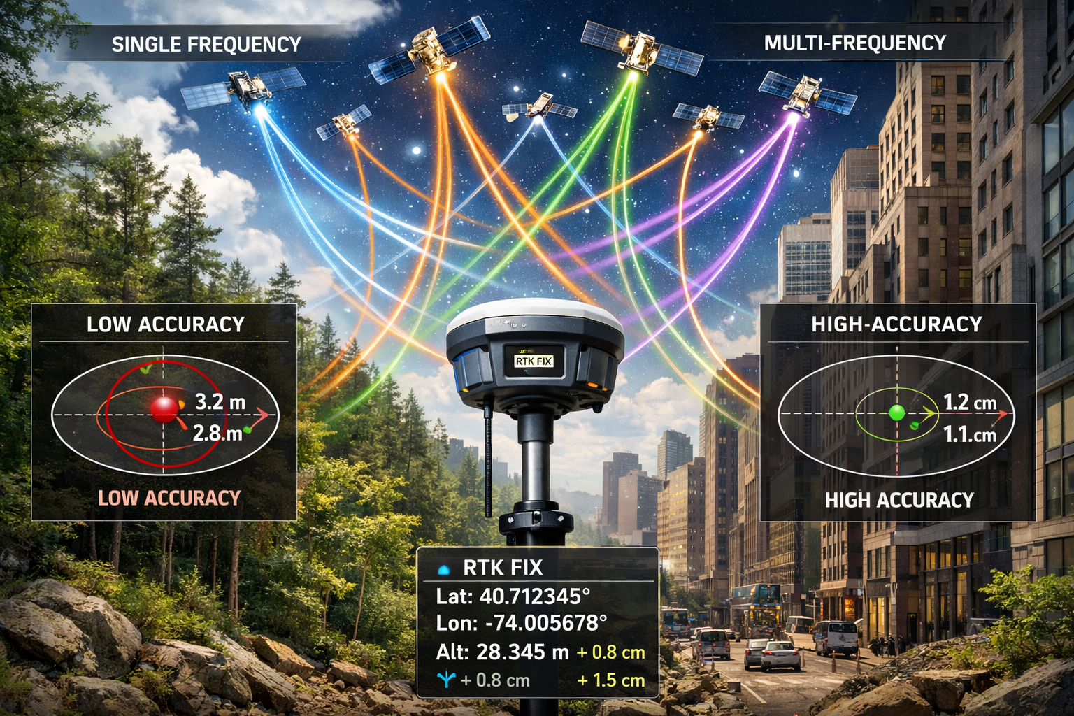
GPS and GNSS systems represent the fastest-growing technology segment, accounting for 30.24% market share in 2026[1]. This rapid expansion reflects the technology's unique advantages in providing real-time positioning without line-of-sight requirements between instrument and measurement points.
Global Navigation Satellite Systems (GNSS) encompass multiple satellite constellations beyond the original U.S. GPS system, including:
- GPS (United States) – 31 operational satellites
- GLONASS (Russia) – 24 operational satellites
- Galileo (European Union) – 30 satellites (full operational capability)
- BeiDou (China) – 35 satellites providing global coverage
Multi-frequency GNSS receivers simultaneously track signals from all available constellations, dramatically improving positioning reliability and accuracy[1]. This multi-constellation approach enhances signal strength and data accuracy, enabling real-time positioning even in challenging field conditions like urban canyons, dense forests, or mountainous terrain[1].
Real-Time Kinematic (RTK) and Network RTK
Real-Time Kinematic positioning represents the gold standard for high-accuracy GNSS surveying. RTK systems achieve centimeter-level accuracy by using correction data from a base station or network of reference stations.
Traditional RTK requires establishing a base station at a known point, which then broadcasts correction signals to rover receivers. This approach works well for projects within 10-15 kilometers of the base station.
Network RTK (NRTK) leverages permanent reference station networks maintained by government agencies or commercial providers. Surveyors subscribe to correction services and receive real-time corrections via cellular data connections. This eliminates the need to establish and maintain base stations, significantly reducing setup time and equipment requirements.
Productivity and Labor Advantages
Advanced GPS/GNSS systems reduce labor intensity and decrease error likelihood by providing real-time positioning information without requiring intensive on-site personnel[1]. A single surveyor with a GNSS rover can collect topographic data, set construction stakes, or verify as-built conditions far more rapidly than traditional methods.
Key productivity benefits include:
🚀 Rapid Data Collection: GNSS receivers capture coordinates in seconds, enabling surveyors to measure hundreds of points per hour
🎯 No Line-of-Sight Required: Unlike total stations, GNSS works without visual connection between instrument and target
📱 Integrated Field Software: Modern receivers run survey software directly on the controller, enabling real-time quality control
☁️ Cloud Connectivity: Immediate data upload to cloud platforms allows office staff to monitor fieldwork progress in real-time
Accuracy Considerations and Limitations
GNSS accuracy depends on several factors:
| Technology | Typical Accuracy | Initialization Time | Ideal Applications |
|---|---|---|---|
| Static GNSS | ±5mm + 0.5ppm | 30-60 minutes | Control networks, geodetic surveys |
| RTK GNSS | ±10mm + 1ppm horizontal | 10-30 seconds | Construction layout, topographic surveys |
| Network RTK | ±20mm + 1ppm horizontal | 5-15 seconds | GIS data collection, utility mapping |
| SBAS (WAAS/EGNOS) | ±1-3 meters | Instant | Navigation, reconnaissance |
However, GNSS technology faces limitations in certain environments:
⚠️ Signal Obstruction: Buildings, bridges, and dense tree canopy block satellite signals
⚠️ Multipath Interference: Signals reflecting off buildings or other structures create positioning errors
⚠️ Atmospheric Conditions: Ionospheric and tropospheric delays affect signal propagation
⚠️ Urban Canyon Effect: Tall buildings create challenging signal geometry
For projects in dense urban environments like Clapham or Fulham, surveyors often combine GNSS with total station measurements to ensure comprehensive coverage.
Integration with Total Stations
Modern surveying workflows increasingly integrate GNSS and total station technology. Surveyors establish control networks using static GNSS methods, then densify measurements using total stations in areas with poor satellite visibility. This hybrid approach leverages the strengths of both technologies while mitigating their respective limitations.
Integrated positioning systems combine GNSS receivers with inertial measurement units (IMUs) and tilt compensation. These systems maintain positioning accuracy even when the survey pole isn't perfectly vertical, significantly improving productivity on rough terrain or in congested sites.
Buying Guide for GPS/GNSS Equipment
When evaluating GNSS receivers for infrastructure and urban development projects:
Multi-Constellation Support: Ensure the receiver tracks all major satellite constellations (GPS, GLONASS, Galileo, BeiDou) for maximum reliability.
Update Rate: Higher update rates (10-20 Hz) benefit machine control applications, while 1 Hz suffices for most surveying work.
Communication Options: Verify compatibility with available RTK correction sources (radio, cellular, satellite).
Controller Platform: Consider whether Android, Windows, or proprietary operating systems best match your workflow requirements.
Battery Life: Field conditions demand receivers with 8+ hour battery life for full-day operation.
Warranty and Support: Evaluate manufacturer service networks and calibration capabilities in your region.
Laser Scanning Technology: High-Density Data Capture
Market Position and Growth Trajectory
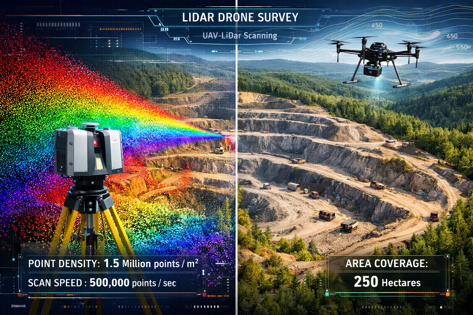
Laser scanning technology has become integral to modern surveying workflows, particularly for high-density point cloud processing, infrastructure development projects, and large-scale land surveys[2]. While terrestrial laser scanners represent a smaller market segment than total stations or GNSS, their capabilities for capturing millions of measurements in minutes make them indispensable for complex projects.
The technology complements total stations and GPS systems in comprehensive surveying solutions, with many projects using all three technologies to achieve optimal coverage and accuracy[1].
Terrestrial Laser Scanners (TLS)
Terrestrial laser scanners mount on tripods and capture detailed 3D representations of their surroundings by rapidly measuring distances to millions of points. Modern scanners achieve:
- Measurement Rates: 50,000 to 2,000,000 points per second
- Range: 0.5 to 1,000+ meters depending on target reflectivity
- Accuracy: ±2mm to ±6mm at 50 meters
- Field of View: 360° horizontal, 300° vertical
Phase-based scanners excel at capturing detailed interior spaces and close-range objects, offering high point density and integrated color imaging.
Time-of-flight scanners provide longer range capabilities essential for infrastructure projects, mining applications, and large industrial facilities.
UAV-LiDAR: The Fastest-Expanding Category
UAV/drone-LiDAR platforms represent the fastest-expanding equipment category, projected to grow at 21.2% CAGR[3]. These systems reached 12.80% market share in 2025, driven by demand for large-area mapping in mining and forestry applications[3].
Drones enable real-time image and video collection with minimal human involvement, significantly enhancing inspection processes and fueling adoption across infrastructure monitoring and environmental oversight applications[1].
UAV-LiDAR systems offer distinct advantages:
✈️ Rapid Coverage: Drones survey hundreds of acres in hours, compared to days or weeks using ground methods
🌲 Vegetation Penetration: LiDAR pulses penetrate tree canopy to capture ground surface beneath
⛰️ Difficult Terrain Access: Drones reach steep slopes, wetlands, and other challenging environments safely
💰 Cost Efficiency: Reduced field time translates to lower project costs for large-area surveys
📊 Comprehensive Data: Simultaneous capture of LiDAR point clouds and high-resolution imagery
Mobile Laser Scanning Systems
Mobile mapping systems mount LiDAR scanners, cameras, and GNSS receivers on vehicles, enabling rapid corridor mapping for transportation projects. These systems capture:
- Highway and railway corridors
- Utility infrastructure along roadways
- Urban streetscapes for city planning
- Pipeline and transmission line rights-of-way
Vehicle-mounted systems achieve productivity of 50-100 kilometers per day, dramatically reducing traffic disruption compared to traditional surveying methods.
Backpack mobile scanners enable surveyors to walk through pedestrian areas, building interiors, or narrow corridors while continuously capturing 3D data.
Point Cloud Processing and Applications
Raw laser scanning data requires substantial processing to generate usable deliverables. Modern workflows include:
- Registration: Aligning multiple scan positions into a unified coordinate system
- Filtering: Removing noise, vegetation, and unwanted objects
- Classification: Categorizing points as ground, buildings, vegetation, utilities, etc.
- Modeling: Creating 3D meshes, CAD drawings, or BIM models from point clouds
- Analysis: Extracting measurements, volumes, and cross-sections
Common applications include:
🏗️ As-Built Documentation: Capturing existing conditions for renovation or expansion projects
🏛️ Historic Preservation: Recording architectural details for restoration work
🏭 Industrial Facilities: Documenting complex piping, equipment, and structural systems
🚧 Deformation Monitoring: Detecting movement in structures, slopes, or excavations
📐 Quantity Takeoffs: Calculating volumes for earthwork, stockpiles, or materials
For building surveys and structural surveys, laser scanning provides unprecedented detail about building conditions, revealing issues invisible to conventional inspection methods.
Integration Considerations
Successful laser scanning implementation requires:
Computing Infrastructure: Point cloud processing demands powerful workstations with high-end graphics cards and substantial RAM (32GB minimum, 64GB+ preferred).
Software Platforms: Specialized software like Leica Cyclone, Faro Scene, Trimble RealWorks, or Autodesk ReCap handles registration and processing.
Data Storage: Large projects generate terabytes of data, requiring robust backup and archival systems.
Staff Training: Effective use of scanning technology requires training in both field data capture and office processing workflows.
Quality Control: Establishing scan resolution, overlap, and accuracy standards ensures deliverables meet project requirements.
Navigating the 2026 Land Survey Equipment Boom: Integration Strategies and Best Practices
Building a Technology Stack for Urban Development Projects
Successfully navigating the 2026 land survey equipment boom requires strategic thinking about technology integration. Rather than viewing total stations, GNSS, and laser scanners as competing technologies, leading surveying firms recognize them as complementary tools that address different project requirements.
Integrated surveying workflows leverage the strengths of each technology:
- GNSS establishes control networks across large project sites, providing reference points in global coordinate systems
- Total stations densify control and provide precise measurements in areas with satellite obstruction
- Laser scanners capture comprehensive 3D data for complex structures or detailed documentation
For projects spanning South West London to South East London, this multi-technology approach ensures complete coverage regardless of site conditions.
Equipment Selection Framework
When navigating equipment purchases in 2026, apply this decision framework:
Step 1: Define Project Requirements
- Typical project size and scope
- Required accuracy levels
- Environmental conditions (urban, rural, industrial)
- Deliverable formats (CAD drawings, point clouds, BIM models)
Step 2: Assess Current Capabilities
- Existing equipment inventory
- Staff expertise and training levels
- Software platforms and workflows
- Client expectations and industry standards
Step 3: Evaluate Technology Options
- Match equipment capabilities to project needs
- Consider productivity improvements and ROI
- Assess manufacturer support and service networks
- Review compatibility with existing systems
Step 4: Consider Acquisition Models
- Purchase vs. lease vs. rental options
- Hardware-as-a-Service subscription benefits
- Total cost of ownership including maintenance
- Upgrade paths and technology obsolescence
Step 5: Plan Implementation
- Staff training requirements
- Workflow integration challenges
- Quality control procedures
- Client communication about new capabilities
Maximizing ROI Through Productivity Gains
The 2026 equipment boom creates opportunities for firms willing to invest strategically. Robotic total stations deliver clear ROI through labor savings—a single surveyor completing work that previously required two professionals generates immediate cost reductions[2].
Multi-frequency GNSS receivers accelerate data collection in challenging environments, reducing project timelines and enabling firms to complete more projects with existing staff[1].
UAV-LiDAR platforms transform the economics of large-area mapping, making projects viable that were previously cost-prohibitive using ground-based methods[3].
Calculate ROI by considering:
💵 Labor Cost Savings: Reduced crew sizes and faster data collection
⏱️ Project Timeline Compression: Completing work faster enables more projects annually
📈 Revenue Expansion: New capabilities open access to previously unavailable project types
🎯 Quality Improvements: Reduced errors minimize costly rework
🏆 Competitive Advantage: Advanced technology differentiates firms in competitive bidding
Cloud-Based Data Management
Modern surveying equipment generates enormous data volumes that traditional file-based workflows struggle to manage. Cloud-based platforms integrated with surveying equipment provide:
- Automatic field data upload via cellular connections
- Real-time project monitoring by office staff and clients
- Collaborative workflows enabling multiple team members to access data simultaneously
- Automated backup protecting against data loss
- Long-term archival with searchable project databases
Leading manufacturers bundle cloud services with equipment subscriptions, creating integrated ecosystems that streamline workflows from field capture through final deliverable production[3].
Interoperability and Open Standards
As surveying firms build technology stacks incorporating equipment from multiple manufacturers, interoperability becomes critical. Support for open data standards ensures smooth workflows:
- LandXML: Standard format for civil engineering and surveying data
- E57: Point cloud data exchange format
- IFC (Industry Foundation Classes): Building information modeling data
- GeoTIFF: Georeferenced raster imagery
- Shapefile/GeoJSON: GIS vector data formats
Verify that equipment and software support these standards to avoid data conversion bottlenecks.
Training and Skill Development
Technology investments deliver returns only when staff can effectively use new equipment. Comprehensive training programs should address:
📚 Equipment Operation: Hands-on field training with new instruments
💻 Software Proficiency: Processing workflows and deliverable creation
🔍 Quality Control: Verification procedures and accuracy assessment
🛠️ Troubleshooting: Common issues and maintenance procedures
📊 Project Planning: Selecting appropriate technology for different project types
Many manufacturers offer training programs, certification courses, and online resources. Budget 5-10% of equipment costs for training to ensure maximum productivity.
Maintenance and Calibration
Surveying equipment requires regular maintenance to maintain accuracy specifications:
- Annual calibration by manufacturer-certified facilities
- Regular cleaning of optical components and sensors
- Firmware updates to access new features and bug fixes
- Battery maintenance to ensure full-day field operation
- Protective cases and transportation procedures to prevent damage
Predictive maintenance enabled by self-diagnostic features helps identify issues before they cause field failures, minimizing costly project delays[3].
Future-Proofing Equipment Investments
The rapid pace of technology development creates obsolescence risks. Mitigate these risks by:
✅ Choosing established manufacturers with long-term support commitments
✅ Verifying upgrade paths for firmware and hardware improvements
✅ Selecting modular systems that allow component upgrades
✅ Negotiating trade-in programs for future equipment purchases
✅ Considering subscription models that include regular equipment updates
Industry Applications Driving Equipment Demand
Infrastructure Development and Smart Cities
Massive infrastructure investments worldwide fuel equipment demand. Transportation networks, utility systems, and smart city initiatives require extensive surveying throughout planning, construction, and maintenance phases. Projects demand:
- High-accuracy control networks for large-scale coordination
- Continuous monitoring of structures and excavations
- As-built documentation for facility management systems
- 3D modeling for design visualization and clash detection
Mining and Resource Extraction
The renewable energy transition increases demand for minerals, driving mining sector expansion[4]. Modern mining operations depend on surveying for:
- Exploration mapping to identify resource deposits
- Mine planning and volume calculations
- Haul road design and equipment guidance
- Environmental compliance monitoring
- Reclamation documentation
UAV-LiDAR systems prove particularly valuable for mining applications, enabling rapid topographic updates and stockpile volume calculations[3].
Renewable Energy Projects
Wind farms, solar installations, and hydroelectric facilities require precision site surveys throughout development:
- Site assessment and resource evaluation
- Turbine and panel layout with millimeter-level accuracy
- Foundation construction surveying
- Transmission line routing
- Environmental impact monitoring
Urban Expansion and Development
Rapid urbanization in Asia and Africa creates sustained surveying demand[4]. Urban development projects require:
- Boundary surveys for property development
- Topographic mapping for site planning
- Construction layout for buildings and infrastructure
- As-built surveys for permitting and documentation
Professionals conducting RICS home surveys and Level 3 building surveys increasingly incorporate laser scanning for detailed documentation of existing structures.
Vendor Landscape and Market Leaders
Major Equipment Manufacturers
The land survey equipment market features several dominant manufacturers:
Trimble Inc. – Leading provider of integrated positioning solutions, offering comprehensive product lines across total stations, GNSS, laser scanners, and software platforms. Known for strong cloud integration and subscription service models[3].
Hexagon AB – Parent company of Leica Geosystems, offering premium surveying instruments with advanced automation features. Strong presence in industrial metrology and reality capture applications[1].
Topcon Corporation – Japanese manufacturer with comprehensive surveying and machine control product lines. Particularly strong in construction and agriculture applications[1].
Trimble bundles hardware leasing with cloud-based analytics platforms, exemplifying the shift toward Hardware-as-a-Service models that reduce upfront capital requirements[3].
Emerging Technology Providers
Newer entrants focus on specialized niches:
- DJI – Dominates the UAV-LiDAR market with integrated drone and sensor systems
- GeoSLAM – Specializes in mobile scanning systems using SLAM technology
- Emlid – Offers affordable GNSS receivers targeting smaller firms and emerging markets
Distribution and Support Networks
Equipment availability and service quality vary significantly by region. When evaluating vendors, consider:
🔧 Local service centers for repairs and calibration
📞 Technical support responsiveness and expertise
📦 Parts availability and warranty terms
🎓 Training programs and certification options
🔄 Rental equipment availability during service periods
Regulatory Considerations and Standards
Accuracy Standards and Specifications
Surveying work must meet various accuracy standards depending on application:
- ALTA/NSPS Land Title Surveys – Specific requirements for property boundary surveys
- State/Provincial Standards – Minimum accuracy requirements for licensed surveyors
- Engineering Tolerances – Project-specific accuracy requirements
- ISO Standards – International equipment calibration and testing protocols
Equipment selection must align with applicable standards for intended applications.
Licensing and Professional Requirements
Most jurisdictions require licensed professional surveyors to certify boundary surveys and legal descriptions. Equipment capabilities don't eliminate professional licensing requirements—technology serves as a tool for licensed professionals, not a replacement.
Data Privacy and Security
Surveying projects often involve sensitive information about property boundaries, infrastructure locations, and security systems. Firms must implement:
- Data encryption for cloud storage and transmission
- Access controls limiting data availability to authorized personnel
- Retention policies complying with legal and contractual requirements
- Backup procedures protecting against data loss
Cost Analysis and Budgeting
Equipment Price Ranges
Survey equipment pricing varies widely based on capabilities:
| Equipment Type | Entry Level | Mid-Range | High-End |
|---|---|---|---|
| Total Station | $3,000-$8,000 | $8,000-$20,000 | $20,000-$50,000+ |
| Robotic Total Station | $15,000-$25,000 | $25,000-$40,000 | $40,000-$80,000+ |
| GNSS Receiver | $2,000-$5,000 | $5,000-$15,000 | $15,000-$30,000+ |
| Terrestrial Laser Scanner | $15,000-$30,000 | $30,000-$70,000 | $70,000-$150,000+ |
| UAV-LiDAR System | $20,000-$50,000 | $50,000-$100,000 | $100,000-$200,000+ |
Total Cost of Ownership
Beyond purchase price, consider:
- Annual calibration: $500-$2,000 per instrument
- Software subscriptions: $1,000-$5,000 annually
- Cloud services: $500-$3,000 annually
- Insurance: 2-5% of equipment value annually
- Training: $1,000-$5,000 per employee
- Accessories: Batteries, tripods, prisms, poles ($2,000-$10,000)
Financing and Acquisition Options
Purchase: Traditional ownership provides full control but requires substantial capital.
Lease: Operating leases preserve capital and may offer tax advantages. Typical terms: 3-5 years.
Rental: Short-term rentals ($200-$1,000 per day) suit occasional needs or project-specific requirements.
Hardware-as-a-Service: Subscription models ($500-$3,000 monthly) include equipment, software, cloud services, and regular upgrades[3].
For smaller firms or those entering new market segments, rental or subscription models minimize financial risk while building experience with new technologies.
Conclusion: Strategic Equipment Decisions in 2026
Navigating the 2026 land survey equipment boom requires balancing technological capabilities with practical business considerations. The market's expansion to $9.22–$10.72 billion reflects genuine transformation in surveying workflows, driven by automation, multi-constellation GNSS, and rapid 3D data capture[1][3][8].
Total stations remain the cornerstone of surveying work, with robotic models delivering compelling productivity gains through single-operator functionality[2][3]. GPS/GNSS systems provide the fastest-growing segment, with multi-frequency receivers enabling reliable positioning in challenging environments[1]. Laser scanning technology, particularly UAV-LiDAR platforms, opens new possibilities for large-area mapping and complex structure documentation[3].
Success in 2026's competitive surveying market depends on strategic technology adoption aligned with business objectives. Rather than pursuing every new technology, focus on capabilities that address specific client needs and project types. Build integrated technology stacks that leverage complementary strengths of different equipment categories.
Actionable Next Steps
For surveying professionals looking to capitalize on the 2026 equipment boom:
1. Assess Current Capabilities – Conduct honest evaluation of existing equipment, identifying gaps in accuracy, productivity, or project types you can serve.
2. Define Strategic Priorities – Determine which market segments offer the best growth opportunities for your firm. Align equipment investments with these strategic goals.
3. Research Equipment Options – Investigate specific models from major manufacturers. Request demonstrations and trial periods to evaluate real-world performance.
4. Calculate ROI Projections – Develop detailed financial models showing expected productivity gains, labor savings, and revenue expansion from equipment investments.
5. Explore Financing Alternatives – Compare purchase, lease, rental, and subscription options to identify the most advantageous approach for your situation.
6. Plan Implementation – Develop comprehensive training programs, workflow integration plans, and quality control procedures before equipment arrives.
7. Monitor Industry Developments – Stay informed about emerging technologies, manufacturer updates, and evolving client expectations to maintain competitive advantage.
The 2026 land survey equipment boom presents extraordinary opportunities for firms willing to invest strategically in technology that enhances capabilities, improves productivity, and delivers exceptional value to clients. Whether working on commercial property surveys or residential projects requiring detailed building surveys, the right equipment makes the difference between merely competing and truly excelling in today's dynamic surveying market.
References
[1] Land Survey Equipment Market 103329 – https://www.fortunebusinessinsights.com/land-survey-equipment-market-103329
[2] Land Surveying Equipment Market Industry Analysis – https://www.technavio.com/report/land-surveying-equipment-market-industry-analysis
[3] Land Survey Equipment Market – https://www.mordorintelligence.com/industry-reports/land-survey-equipment-market
[4] Global Land Survey Equipment Market – https://www.kenresearch.com/industry-reports/global-land-survey-equipment-market
[5] The Future Of Land Surveying Technology And Upcoming Trends In 2026 – https://metricop.com/blogs/land-surveying/the-future-of-land-surveying-technology-and-upcoming-trends-in-2026
[6] Land Survey Equipment Global Market Report – https://www.thebusinessresearchcompany.com/report/land-survey-equipment-global-market-report
[7] Land Survey Equipment Market To Reach Us 15 0 Bn By 2032 Says Persistence Market Research – https://world.einnews.com/pr_news/889890983/land-survey-equipment-market-to-reach-us-15-0-bn-by-2032-says-persistence-market-research
[8] Land Survey Equipment Market Global Forecast – https://www.researchandmarkets.com/reports/5716131/land-survey-equipment-market-global-forecast