
The construction and property surveying industries stand at a technological crossroads in 2026. Traditional measurement methods that served professionals for decades are rapidly giving way to revolutionary digital approaches that capture entire buildings in hours rather than weeks. 3D Laser Scanning Mastery: Techniques and Benefits for Modern Property Surveys represents the convergence of precision engineering, digital modeling, and practical field application—transforming how surveyors, architects, and construction managers document, analyze, and manage built environments.
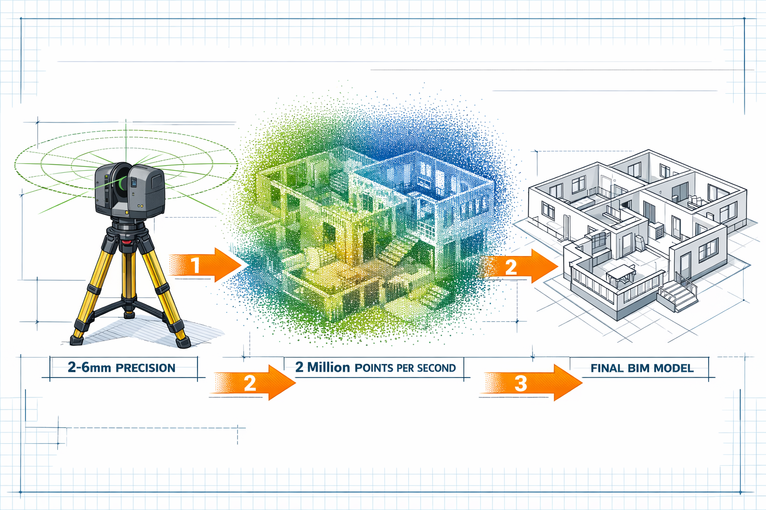
Modern terrestrial laser scanners now capture 2 million points per second with accuracy levels reaching 2-6 millimeters across entire surfaces.[1][2] This technological leap enables professionals to complete comprehensive property documentation 5-10 times faster than conventional approaches while simultaneously reducing errors, enhancing safety, and providing unprecedented detail for Building Information Modeling (BIM) integration.[2]
Key Takeaways
✅ Speed and Efficiency: 3D laser scanning completes data collection 5-10 times faster than traditional methods, with complex building documentation finishing in hours instead of weeks.[2]
✅ Precision Accuracy: Modern scanners achieve 2-6 millimeter accuracy across entire surfaces, with high-end systems reaching sub-millimeter precision for millions of data points.[2]
✅ Cost Reduction: Scanning technology reduces labor requirements, eliminates costly rework through high accuracy, and minimizes field trips while enhancing personnel safety.[3]
✅ BIM Integration: Point cloud data integrates directly with BIM software, supporting digital twins development, clash detection, and automated progress tracking throughout project lifecycles.[2][5]
✅ Comprehensive Documentation: Scanners capture complete environmental context including complex MEP systems, structural elements, and architectural details that traditional methods struggle to measure efficiently.[2]
Understanding 3D Laser Scanning Technology for Property Surveys
What Is 3D Laser Scanning?
3D laser scanning (also known as LiDAR—Light Detection and Ranging) represents a non-contact, non-destructive technology that digitally captures the physical dimensions of objects, structures, and environments. The scanner emits rapid laser pulses that reflect off surfaces and return to the sensor. By measuring the time-of-flight for each pulse, the system calculates precise distances and creates a dense collection of measurement points called a point cloud.[7]
These point clouds contain millions of individual measurements, each with specific X, Y, and Z coordinates that collectively form a highly accurate three-dimensional representation of the scanned environment.[1] Modern systems integrate photography to add color information, creating visually rich datasets that bridge the gap between raw measurement data and recognizable imagery.[2]
How Terrestrial Laser Scanners Work
The operational principle behind terrestrial laser scanning combines several sophisticated technologies:
Laser Emission and Detection: The scanner projects laser beams in systematic patterns, typically rotating 360 degrees horizontally while simultaneously tilting vertically to capture a complete spherical field of view. High-performance systems emit and receive millions of laser pulses per second.[1]
Time-of-Flight Calculation: The scanner's internal processor measures the nanosecond-level time interval between laser emission and return, calculating distance using the constant speed of light. This process repeats millions of times per minute to build comprehensive datasets.[2]
Angular Measurement: Precision encoders track the exact horizontal and vertical angles of each laser pulse, enabling the system to calculate the three-dimensional position of every measured point relative to the scanner's location.[2]
Data Registration: Multiple scan positions are combined through a process called registration, which aligns overlapping point clouds into a unified coordinate system. Modern systems feature automated target recognition and real-time registration capabilities that streamline this process.[2]
Types of 3D Laser Scanning Systems
| Scanner Type | Range | Accuracy | Best Applications |
|---|---|---|---|
| Short-Range | 0.5-30m | Sub-millimeter | Interior documentation, detailed architectural features, MEP systems |
| Medium-Range | 30-120m | 2-6mm | Building facades, structural surveys, construction sites |
| Long-Range | 120-1000m+ | 5-10mm | Infrastructure corridors, large industrial facilities, topographic surveys |
| Mobile Scanning | Variable | 10-30mm | Roadways, tunnels, rapid site documentation |
Each system type serves specific applications within property surveying, with many professionals maintaining multiple scanner types to address diverse project requirements.
Step-by-Step Techniques for 3D Laser Scanning Mastery in Property Surveys
Pre-Scan Planning and Site Assessment
Successful scanning projects begin long before equipment arrives on site. Proper planning determines scan locations, identifies potential obstacles, and establishes project-specific accuracy requirements.[2]
Site Reconnaissance: Visit the property to identify optimal scanner positions that maximize coverage while minimizing scan sessions. Consider accessibility, safety hazards, and environmental conditions that might affect data quality.[7]
Scan Position Planning: Determine the number and location of scan setups required to capture all necessary areas with sufficient overlap (typically 30-50%) for accurate registration. Complex properties may require dozens of scan positions.[2]
Target Placement: Position survey targets (spheres, checkerboards, or reflective markers) in areas visible from multiple scan positions. These targets serve as common reference points for registration and coordinate system establishment.[2]
Coordination with Stakeholders: When conducting surveys for homebuyer surveys or construction documentation, coordinate with property owners, tenants, and contractors to ensure site access and minimize disruptions.[7]
Equipment Setup and Calibration
Modern scanning systems feature automatic calibration that ensures consistent data quality, but proper setup remains critical for optimal results.[1]
Leveling and Positioning: Mount the scanner on a stable tripod and carefully level the instrument. Even slight deviations from level can introduce systematic errors across the entire scan.[2]
Scanner Configuration: Configure scan resolution (point spacing), scan area (field of view), and quality settings based on project requirements. Higher resolution produces denser point clouds but requires longer scan times.[2]
Environmental Considerations: Account for temperature, humidity, and lighting conditions. Extreme temperatures can affect instrument performance, while bright sunlight may reduce effective range for some systems.[7]
Safety Protocols: Establish safety perimeters and warning signage. While laser scanners use eye-safe Class 1 or Class 2 lasers, proper safety procedures protect both operators and bystanders.[1]
Data Collection Workflow
The actual scanning process follows a systematic workflow that balances thoroughness with efficiency:
Initial Reference Scan: Begin with a comprehensive scan from a central location that captures the overall property layout and serves as the registration foundation for subsequent scans.[2]
Systematic Coverage: Progress through planned scan positions methodically, ensuring adequate overlap between adjacent scans. Modern systems display real-time coverage maps that help operators identify gaps.[1]
Quality Verification: Review each scan immediately after capture using the scanner's built-in display or connected tablet. Check for adequate density, proper target capture, and absence of motion artifacts from moving objects.[2]
Supplementary Photography: Capture high-resolution photographs from each scan position. Integrated photography systems automatically align images with point cloud data, adding color information that enhances visualization and interpretation.[2]
Documentation: Maintain detailed records of scan positions, environmental conditions, and any anomalies encountered. This documentation proves invaluable during post-processing and quality assurance.[7]
Point Cloud Registration and Processing
Raw scan data requires processing to transform individual scans into unified, usable datasets:
Registration Methods: Align multiple scans using either target-based registration (utilizing survey targets visible in overlapping scans) or cloud-to-cloud registration (matching geometric features between scans). Many projects combine both approaches for optimal accuracy.[2]
In-Field Registration: Advanced systems like Trimble platforms feature in-field registration that provides immediate feedback on alignment quality, allowing operators to capture additional scans if needed before leaving the site.[1] This capability significantly increases data capture confidence and reduces costly return visits.
Coordinate System Transformation: Transform point cloud data into project-specific coordinate systems or standard reference systems (local grid, state plane, or geographic coordinates) using surveyed control points.[2]
Data Cleaning: Remove extraneous points from moving objects, vegetation, or scanning artifacts. Modern software includes automated filtering tools that accelerate this process while maintaining critical detail.[2]
Data Optimization: Reduce point cloud density in areas where extreme detail isn't required, creating manageable file sizes without sacrificing necessary accuracy. This optimization balances data richness with computational efficiency.[2]
Integration with BIM and Digital Modeling
The true power of 3D Laser Scanning Mastery: Techniques and Benefits for Modern Property Surveys emerges through seamless integration with Building Information Modeling platforms:
Point Cloud Import: Import registered point clouds directly into BIM software (Revit, ArchiCAD, Navisworks) where they serve as three-dimensional reference backgrounds for modeling.[2]
As-Built Modeling: Create accurate BIM models by tracing over point cloud data, capturing actual built conditions rather than relying on potentially outdated design drawings. This approach proves particularly valuable for renovation projects and structural surveys.[2]
Automated Feature Extraction: Utilize artificial intelligence and machine learning algorithms that automatically identify and model common building elements (walls, floors, ceilings, doors, windows) from point cloud data, dramatically reducing manual modeling time.[5]
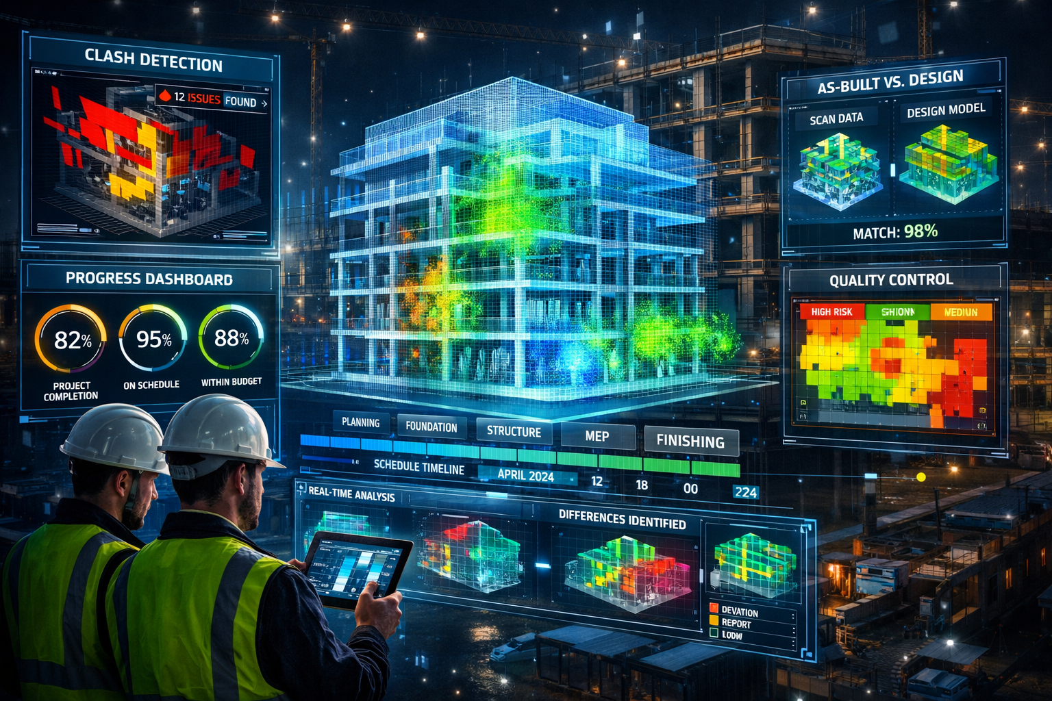
Clash Detection: Compare point cloud data against design models to identify discrepancies between intended and actual construction. This automated comparison reveals installation errors, conflicts, and deviations from specifications.[2][5]
Digital Twin Development: Establish comprehensive digital twins that combine geometric point cloud data with operational information, creating dynamic models that support facility management throughout the building lifecycle.[2]
Comprehensive Benefits of 3D Laser Scanning for Modern Property Surveys
Unprecedented Speed and Efficiency
The velocity advantage of laser scanning fundamentally changes project timelines and resource allocation:
Rapid Data Acquisition: Complete comprehensive building documentation in hours instead of weeks. A single scanner setup captures thousands of square feet of detailed information in minutes, with modern systems reaching 2 million points per second.[1][2]
Reduced Site Visits: Capture complete datasets in one or two site visits rather than multiple return trips required by traditional measurement approaches. This reduction proves particularly valuable for properties with limited access or occupied spaces.[3]
Accelerated Project Delivery: Compress overall project schedules by eliminating measurement bottlenecks. Teams can begin analysis and design work immediately after scanning rather than waiting for weeks of manual measurement and drafting.[2]
Parallel Workflows: Enable multiple team members to work simultaneously from the same point cloud dataset, analyzing different building systems, conducting various analyses, or creating diverse deliverables without scheduling conflicts.[2]
For professionals conducting drone surveys alongside terrestrial scanning, the combined approach delivers comprehensive site documentation that includes both aerial context and detailed ground-level precision.
Superior Accuracy and Data Completeness
Precision represents more than a technical specification—it directly impacts project outcomes and risk management:
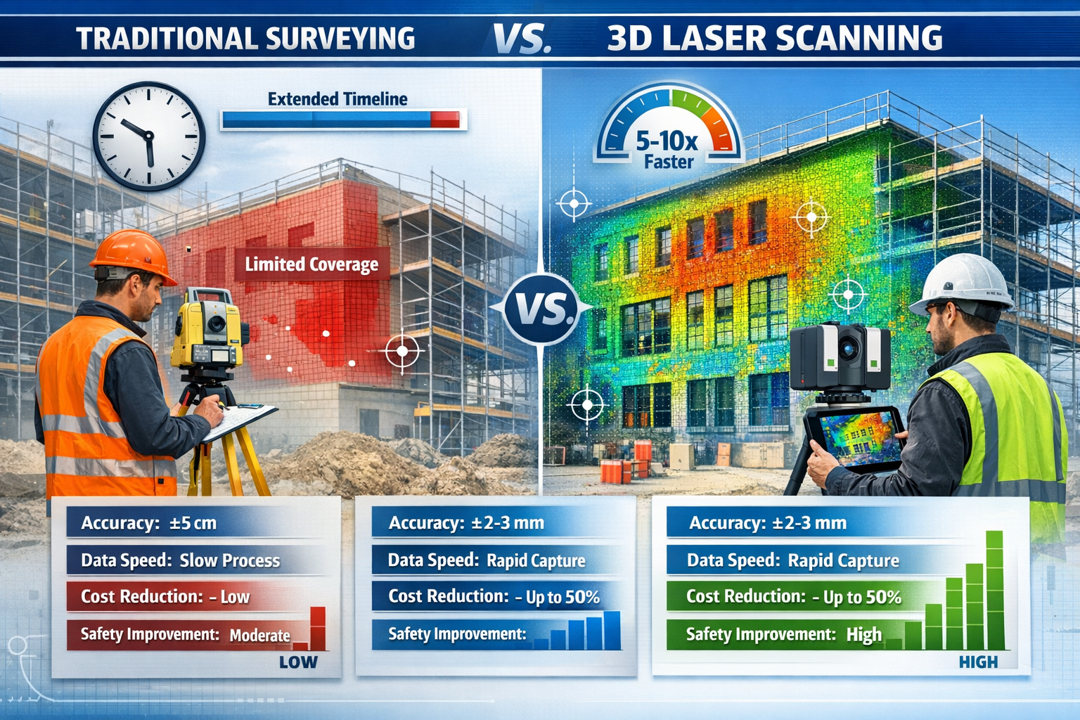
Millimeter-Level Precision: Achieve 2-6 millimeter accuracy across entire surfaces, with high-end systems reaching sub-millimeter precision.[2] This accuracy level exceeds what's practical with traditional measurement tools across large areas.
Comprehensive Coverage: Capture complete environmental context rather than selective measurements. Point clouds document everything within the scan area, preserving details that might not seem important during initial data collection but prove valuable later.[2]
Reduced Human Error: Eliminate transcription mistakes, measurement errors, and field note misinterpretations that commonly occur with manual surveying. Automated data capture removes human subjectivity from the measurement process.[3]
Verification and Validation: Maintain permanent digital records that allow independent verification of measurements and dimensions long after field work concludes. This capability supports dispute resolution and quality assurance.[2]
Complex Geometry Documentation: Accurately capture irregular surfaces, curved elements, and intricate details that challenge traditional measurement methods. This capability proves essential for heritage documentation and renovation projects.[7]
Significant Cost Reduction
While initial equipment investment appears substantial, the economic benefits accumulate rapidly:
Labor Efficiency: Perform more work with fewer personnel and less time by transitioning to 3D laser scanning.[3] A two-person scanning team often accomplishes what previously required five or more surveyors using conventional methods.
Elimination of Rework: High accuracy reduces mistakes that lead to costly rework during construction. Catching dimensional conflicts during design rather than construction saves exponentially more than the scanning investment.[3]
Reduced Travel Expenses: Fewer site visits translate directly to lower travel costs, vehicle expenses, and per diem allowances. This advantage multiplies for projects involving multiple properties or distant locations.[3]
Software Integration: Modern scanning systems include integrated software that eliminates separate software purchases, with modular additions available as project needs evolve.[1]
Risk Mitigation: Comprehensive documentation reduces liability exposure by providing definitive records of existing conditions, protecting professionals against claims related to measurement accuracy or completeness.[2]
Enhanced Safety for Survey Personnel
Safety improvements extend beyond regulatory compliance to fundamental risk reduction:
Distance from Hazards: Laser scanning's extended range allows operators to distance themselves from dangerous situations—unstable structures, busy roadways, hazardous materials, or extreme heights.[1] This capability, sometimes called "virtual surveying," fundamentally changes risk exposure.
Reduced Time in Danger Zones: Minimize time personnel spend in hazardous environments. What might require hours of manual measurement in dangerous locations often reduces to minutes of scanning from safe positions.[1]
Remote and Autonomous Operation: Couple scanners with autonomous or remote-controlled devices for situations where human presence poses unacceptable risks. This approach proves particularly valuable in mines, tunnels, and industrial facilities.[1]
Comprehensive Documentation: Capture complete site conditions including safety hazards, enabling better planning for subsequent work phases without requiring personnel to re-enter dangerous areas for additional measurements.[7]
When conducting roof surveys or other elevated work, scanning from ground level eliminates fall risks while still capturing comprehensive roof geometry and condition information.
Progress Tracking and Quality Control
Construction monitoring represents one of laser scanning's most valuable applications:
Automated Progress Verification: Research studies from 2024 to 2026 consistently demonstrate that integrating BIM with laser scanning improves progress tracking accuracy and significantly reduces manual inspection effort.[5]
Periodic Scan Comparison: Conduct daily, weekly, or milestone-based LiDAR scans registered with 4D BIM models. Automated point cloud-to-BIM comparisons determine what's been built, what's missing, and where work falls outside allowable tolerances.[5]
Dimensional Quality Control: Verify that constructed elements match design specifications within acceptable tolerances. This verification occurs before subsequent work proceeds, preventing cascading errors.[2]
MEP Coordination: Document complex mechanical, electrical, and plumbing systems as-installed, creating accurate records for facility management and future maintenance planning.[2]
Payment Verification: Provide objective documentation of work completion percentages for progress payment verification, reducing disputes between owners and contractors.[5]
Versatile Application Across Property Types
The technology adapts to diverse property survey requirements:
Residential Properties: Support Level 2 home surveys and Level 3 surveys with comprehensive documentation of existing conditions, structural elements, and dimensional relationships.[7]
Commercial Buildings: Document office buildings, retail centers, and mixed-use developments for renovation planning, tenant improvements, and facility management.[2]
Industrial Facilities: Capture petrochemical plants, manufacturing facilities, and power generation stations for maintenance documentation while minimizing personnel exposure to hazardous environments.[2]
Infrastructure Projects: Support highway departments across North America with pavement analysis, bridge inspections, and corridor planning applications.[2]
Heritage and Historic Preservation: Create detailed records of historic structures for conservation planning, restoration work, and archival documentation.[7]
Hybrid Methodology: Combining Traditional and Modern Surveying Approaches
Complementary Strengths of Combined Methods
3D Laser Scanning Mastery: Techniques and Benefits for Modern Property Surveys doesn't eliminate traditional surveying—it enhances and complements conventional approaches:
Control Network Establishment: Traditional surveying methods remain essential for establishing accurate control networks that provide the coordinate system foundation for laser scanning projects.[2] Total stations and GPS receivers deliver the positional accuracy required for georeferencing point clouds.
Boundary Determination: Property boundaries and legal descriptions require traditional surveying methods that meet jurisdictional standards for land ownership documentation. Laser scanning complements but doesn't replace land surveyors for boundary work.[2]
Selective Detail Capture: Use traditional measurements for specific critical dimensions that require certified accuracy for legal or regulatory purposes, while employing scanning for comprehensive environmental documentation.[2]
Verification and Validation: Traditional spot measurements provide independent verification of scanning accuracy, ensuring quality control and building confidence in point cloud data.[2]
Many successful projects employ hybrid methodology, using traditional surveying for control networks and boundary establishment while deploying 3D laser scanning for detailed documentation and analysis.[2] This combination leverages each technology's strengths while mitigating individual limitations.
When to Choose Scanning vs. Traditional Methods
| Project Characteristic | Recommended Approach | Rationale |
|---|---|---|
| Complex geometry, irregular surfaces | 3D Laser Scanning | Captures complete detail efficiently |
| Legal boundary determination | Traditional Surveying | Meets regulatory and legal requirements |
| Large-area documentation | 3D Laser Scanning | Speed and coverage advantages |
| Specific critical dimensions | Traditional Surveying | Certified accuracy for legal purposes |
| As-built documentation | 3D Laser Scanning | Comprehensive environmental context |
| Control network establishment | Traditional Surveying | Foundation for coordinate systems |
| Renovation planning | Hybrid Approach | Control + detailed documentation |
| Construction progress tracking | 3D Laser Scanning | Automated comparison capabilities |
Understanding these distinctions helps professionals select appropriate methodologies for specific project requirements, optimizing both accuracy and efficiency.
Real-World Applications and Case Studies
Construction Project Documentation
Modern construction projects increasingly rely on laser scanning throughout the building lifecycle:
Pre-Construction Surveys: Document existing site conditions before construction begins, establishing baseline records that protect against damage claims and inform design decisions.[2]
Foundation and Structural Verification: Verify foundation placement, structural steel installation, and concrete formwork before subsequent construction phases proceed. Early detection of dimensional errors prevents costly corrections later.[5]
MEP System Documentation: Capture complex mechanical, electrical, and plumbing installations as-built, creating accurate records for coordination, clash detection, and facility management.[2]
Final As-Built Records: Deliver comprehensive as-built documentation that reflects actual constructed conditions rather than design intent, providing facility managers with accurate information for maintenance and future modifications.[2]
Projects incorporating scanning alongside traditional construction surveys achieve superior documentation quality while maintaining schedule efficiency.
Renovation and Retrofit Projects
Existing building work presents unique challenges where scanning delivers exceptional value:
Existing Condition Assessment: Create accurate baseline models of existing structures before renovation design begins. Point clouds reveal actual conditions including previous modifications, concealed elements, and dimensional variations.[7]
Design Development: Enable architects and engineers to design renovations based on precise existing conditions rather than assumptions or outdated drawings. This accuracy reduces change orders and construction surprises.[2]
Historical Documentation: Preserve detailed records of heritage buildings before, during, and after restoration work, supporting conservation efforts and creating archival documentation.[7]
Tenant Improvement Planning: Document existing commercial spaces for tenant improvement design, capturing current layouts, ceiling heights, and MEP system locations.[2]
Infrastructure and Transportation Projects
Highway departments and transportation agencies increasingly adopt scanning technology:
Pavement Analysis: Document roadway surface conditions, cross-slopes, and geometric characteristics for maintenance planning and reconstruction design.[2]
Bridge Inspection: Capture detailed bridge geometry including clearances, structural elements, and condition indicators without disrupting traffic or exposing inspectors to safety risks.[2]
Corridor Planning: Document existing highway corridors for widening projects, interchange modifications, and utility coordination.[2]
Tunnel Documentation: Safely capture tunnel geometry and condition information using scanning techniques that minimize personnel exposure and traffic disruption.[1]
Industrial Facility Management
Complex industrial environments benefit substantially from scanning capabilities:
Plant Documentation: Create comprehensive as-built records of petrochemical plants, refineries, and manufacturing facilities for maintenance planning and modification design.[2]
Turnaround Planning: Support scheduled maintenance shutdowns with detailed documentation that enables precise planning before expensive downtime begins.[2]
Expansion Design: Document existing facilities for expansion projects, capturing current configurations and spatial constraints that inform new design.[2]
Safety and Emergency Planning: Provide emergency responders with detailed facility models that support emergency planning and response coordination.[1]
Overcoming Common Challenges in 3D Laser Scanning
Data Management and File Size Considerations
Point clouds generate massive datasets that require careful management:
Storage Requirements: Plan for substantial storage capacity. Comprehensive building scans easily generate hundreds of gigabytes of raw data. Cloud storage solutions and network-attached storage systems address these requirements.[2]
Processing Power: Invest in workstations with robust processors, substantial RAM (32GB minimum, 64GB+ preferred), and professional graphics cards capable of handling large point cloud datasets.[2]
Data Organization: Implement systematic file naming conventions and folder structures that maintain organization across multiple projects and scan sessions.[7]
Backup Protocols: Establish redundant backup systems protecting against data loss. The investment in scanning becomes worthless if data corruption or hardware failure destroys the only copy.[2]
Environmental and Operational Limitations
Understanding scanning limitations prevents disappointment and project delays:
Reflective Surfaces: Highly reflective materials (mirrors, polished metal, glass) may produce erroneous measurements or data gaps. Identify these surfaces during planning and employ supplementary measurement methods.[7]
Transparent Materials: Glass and other transparent materials allow laser beams to pass through rather than reflecting, creating gaps in point clouds. Document glass locations separately.[7]
Moving Objects: People, vehicles, and equipment moving during scans create artifacts in point cloud data. Schedule scanning during periods of minimal activity or use filtering techniques to remove motion artifacts.[2]
Extreme Lighting: Very bright sunlight can reduce effective scanning range for some systems. Plan outdoor scanning for optimal lighting conditions or use scanners specifically designed for bright environments.[7]
Weather Conditions: Rain, snow, and fog interfere with laser measurements. Monitor weather forecasts and schedule outdoor scanning during suitable conditions.[7]
Training and Skill Development
Achieving 3D Laser Scanning Mastery: Techniques and Benefits for Modern Property Surveys requires investment in education:
Manufacturer Training: Participate in comprehensive training programs offered by scanner manufacturers. These programs cover equipment operation, maintenance, and basic processing techniques.[1]
Software Proficiency: Develop expertise in point cloud processing software and BIM integration tools. Many software vendors offer certification programs demonstrating proficiency.[2]
Continuing Education: Technology evolves rapidly. Commit to ongoing education through industry conferences, webinars, and professional development courses.[4]
Practical Experience: Gain hands-on experience through progressively complex projects. Start with straightforward documentation tasks before advancing to challenging applications.[7]
Professionals already conducting property surveys can integrate scanning capabilities incrementally, building expertise while maintaining traditional service offerings.
Future Trends and Emerging Technologies in 3D Laser Scanning
Artificial Intelligence and Automated Processing
The integration of AI and machine learning transforms point cloud workflows:
Automated Feature Recognition: Advanced algorithms automatically identify and classify building elements (walls, doors, windows, structural members) from point cloud data, dramatically reducing manual modeling time.[5]
Intelligent Filtering: Machine learning systems distinguish between permanent features and temporary objects, automatically removing construction equipment, vehicles, and other transient elements.[5]
Predictive Maintenance: AI analysis of periodic scans identifies subtle changes indicating developing structural issues, enabling proactive maintenance before failures occur.[4]
Quality Control Automation: Automated comparison algorithms detect deviations from design specifications without manual inspection, flagging issues for human review.[5]
Mobile and Wearable Scanning Systems
Portability and ease of use continue improving:
Handheld Scanners: Lightweight handheld devices enable rapid scanning in confined spaces and complex environments where tripod-mounted systems prove impractical.[4]
Backpack Systems: Wearable scanning systems allow operators to walk through buildings and sites, capturing continuous data streams that create comprehensive models.[4]
Smartphone Integration: Consumer devices incorporating LiDAR sensors democratize basic scanning capabilities, though professional applications still require dedicated equipment.[4]
Drone-Mounted Scanners: Aerial scanning systems combine the coverage advantages of drone surveys with the precision of laser scanning, particularly valuable for large sites and infrastructure projects.[4]
Cloud-Based Processing and Collaboration
Connectivity transforms how teams work with scan data:
Cloud Processing: Offload computationally intensive processing tasks to cloud servers, enabling teams to work with large datasets on standard computers.[4]
Real-Time Collaboration: Multiple team members access and annotate point cloud data simultaneously from different locations, accelerating review and decision-making processes.[4]
Web-Based Visualization: View and interact with point cloud data through web browsers without specialized software, improving accessibility for stakeholders.[4]
Automated Deliverable Generation: Cloud platforms automatically generate standard deliverables (floor plans, elevations, sections) from point cloud data based on predefined templates.[4]
Integration with Augmented and Virtual Reality
Immersive technologies enhance how professionals interact with scan data:
AR Field Verification: Overlay design models on physical environments using augmented reality, enabling real-time comparison between intended and actual conditions during construction.[4]
VR Design Review: Conduct immersive design reviews within point cloud environments, allowing stakeholders to experience spaces at full scale before construction.[4]
Remote Site Visits: Enable remote stakeholders to virtually visit sites through VR environments created from point cloud data, reducing travel requirements.[4]
Training Simulations: Use point cloud-based VR environments for safety training and construction sequencing planning.[4]
Implementing 3D Laser Scanning in Your Practice
Equipment Selection Considerations
Choosing appropriate scanning equipment requires careful evaluation:
Project Requirements: Assess typical project sizes, required accuracy levels, and environmental conditions. Match scanner specifications to actual needs rather than purchasing excessive capability.[1]
Budget Constraints: Balance initial equipment costs against anticipated project volume and revenue potential. Consider leasing options for occasional use.[3]
Manufacturer Support: Evaluate manufacturer training programs, technical support availability, and equipment service networks. Reliable support proves critical when problems arise.[1]
Software Ecosystem: Consider software compatibility and integration capabilities. Seamless workflows between scanning hardware and processing software maximize efficiency.[1]
Scalability: Select systems that accommodate future capability expansion through modular upgrades rather than complete replacement.[1]
Building Internal Expertise
Successful implementation extends beyond equipment acquisition:
Champion Identification: Designate enthusiastic team members as scanning champions who develop deep expertise and mentor others.[7]
Gradual Integration: Introduce scanning on straightforward projects before tackling complex applications. Build confidence and competence incrementally.[7]
Process Documentation: Develop standard operating procedures documenting workflows, quality control measures, and deliverable specifications.[7]
Quality Assurance: Implement verification procedures ensuring scan data meets accuracy requirements and deliverables satisfy client expectations.[2]
Client Education: Help clients understand scanning capabilities, benefits, and deliverable formats. Educated clients become advocates for the technology.[7]
Marketing Scanning Services
Differentiate your practice by effectively communicating scanning capabilities:
Portfolio Development: Create compelling case studies demonstrating scanning applications, benefits achieved, and client value delivered.[7]
Visual Communication: Use point cloud visualizations, animations, and before-after comparisons that clearly illustrate scanning advantages.[2]
Educational Content: Publish articles, videos, and presentations explaining scanning technology and applications to potential clients.[7]
Professional Networking: Participate in industry organizations and events where potential clients and referral partners gather.[7]
Service Integration: Position scanning as an enhancement to existing services rather than a separate offering. Integrate scanning into homebuyer surveys, structural assessments, and other established services.[7]
Conclusion: Embracing the Future of Property Surveying
3D Laser Scanning Mastery: Techniques and Benefits for Modern Property Surveys represents far more than technological advancement—it fundamentally transforms how professionals document, analyze, and manage built environments. The convergence of millimeter-level accuracy, million-point-per-second data capture, and seamless BIM integration creates unprecedented opportunities for surveyors, architects, engineers, and construction managers in 2026 and beyond.
The compelling advantages are clear: 5-10 times faster data collection, 2-6 millimeter accuracy across entire surfaces, significant cost reduction through labor efficiency and error elimination, enhanced safety through distance and reduced exposure, and comprehensive documentation that captures complete environmental context.[1][2][3] These benefits extend across diverse applications from residential property surveys to complex infrastructure projects.
Yet technology alone doesn't guarantee success. True mastery requires systematic skill development, thoughtful integration of traditional and modern methodologies, careful attention to data management, and commitment to ongoing education as capabilities continue evolving. The professionals who thrive recognize that scanning enhances rather than replaces fundamental surveying expertise, combining cutting-edge tools with time-tested principles.
Actionable Next Steps
For Professionals Considering Adoption:
-
Assess Current Needs: Evaluate your typical project portfolio to identify applications where scanning delivers maximum value. Consider starting with renovation documentation or construction progress monitoring where benefits prove most dramatic.
-
Invest in Education: Participate in manufacturer training programs and industry workshops before equipment purchase. Understanding capabilities and limitations prevents costly mistakes and accelerates competency development.
-
Start Small, Scale Strategically: Begin with entry-level or mid-range equipment appropriate for initial applications. Expand capabilities as expertise and project volume justify investment in advanced systems.
-
Build Partnerships: Collaborate with experienced scanning professionals on initial projects. Learning from practitioners with established expertise accelerates your development curve.
-
Develop Workflows: Create documented procedures covering planning, data collection, processing, and deliverable generation. Systematic workflows ensure consistency and quality across projects.
For Property Owners and Project Managers:
-
Specify Scanning Requirements: Include 3D laser scanning specifications in project scopes where appropriate. Clear requirements ensure deliverables meet project needs.
-
Verify Provider Qualifications: Assess scanning service providers based on equipment capabilities, operator training, project experience, and quality assurance procedures.
-
Understand Deliverables: Clarify expected deliverable formats, accuracy specifications, and data ownership before projects begin. Preventing misunderstandings saves time and frustration.
-
Leverage Data Value: Recognize that point cloud data serves multiple purposes throughout project lifecycles. Archive data for future renovation planning, facility management, and dispute resolution.
-
Stay Informed: Monitor technological developments and emerging applications. Early adoption of beneficial innovations provides competitive advantages.
The future of property surveying combines human expertise with technological capability, creating opportunities for professionals who embrace change while maintaining fundamental principles. Whether you're a chartered surveyor in London or anywhere else, the journey toward 3D laser scanning mastery begins with a single step—and the destination promises enhanced service quality, improved efficiency, and expanded professional opportunities.
The question isn't whether to adopt this transformative technology, but how quickly to begin the journey toward mastery. The built environment continues growing in complexity, client expectations continue rising, and competitive pressures continue intensifying. Those who master 3D laser scanning techniques position themselves at the forefront of professional practice, delivering superior value while building sustainable competitive advantages.
Start your journey today. The future of property surveying is already here—and it's captured in millions of precisely measured points.
References
[1] 3d Laser Scanning New Opportunities For Surveying And Mapping Professionals – https://geospatial.trimble.com/blog/geospatial/en-US/article/3d-laser-scanning-new-opportunities-for-surveying-and-mapping-professionals
[2] 3d Scanning Vs Traditional Surveying Guide – https://iscano.com/laser-scanning-lidar-best-practices/3d-scanning-vs-traditional-surveying-guide/
[3] 3d Laser Scanning Used In Land Surveying – https://www.duncan-parnell.com/blog/108/3d-laser-scanning-used-in-land-surveying
[4] The Future Of Land Surveying Technology And Upcoming Trends In 2026 – https://metricop.com/blogs/land-surveying/the-future-of-land-surveying-technology-and-upcoming-trends-in-2026
[5] 7 Reasons To Use Lidar Construction Laser Scanning – https://blog.brightergraphics.com/7-reasons-to-use-lidar-construction-laser-scanning
[7] 3d Laser Scanning What Is It When You Need It – https://terrainsurveys.co.uk/news-and-media/3d-laser-scanning/3d-laser-scanning-what-is-it-when-you-need-it