
{"cover":"Professional landscape format (1536×1024) hero image with bold text overlay: 'Ecological Forecasting in Surveys: Predicting Development Impacts Before Breaking Ground', extra large 72pt white bold sans-serif font with dark semi-transparent overlay box, centered upper-third composition. Background shows a sweeping aerial view of a green landscape transitioning into an urban development zone, with GIS map overlays and biodiversity heat maps digitally composited over the scene. Color palette: deep forest green, slate blue, crisp white. Magazine cover aesthetic, editorial quality, high contrast, cinematic depth of field.","content":["Detailed landscape format (1536×1024) illustration showing a surveyor at a field site holding a tablet displaying a GIS biodiversity map with color-coded habitat zones, flood risk overlays, and AI-generated species distribution models. Background shows undeveloped green land adjacent to a construction boundary marker. Digital data streams and map grid lines overlay the scene. Color scheme: teal, dark green, white data labels. Editorial quality, technical infographic style, wide-angle perspective from ground level looking across the site.","Detailed landscape format (1536×1024) top-down aerial perspective of a construction planning desk with large printed ecological forecast maps, laptop showing machine learning model outputs predicting habitat loss percentages, alongside RICS survey documents and green certification checklists. Hands of a planner and surveyor pointing at key data points. Color scheme: warm amber desk tones, green map overlays, blue digital screen glow. Clean, professional editorial style, sharp focus on documents and screen data.","Detailed landscape format (1536×1024) split-screen concept image: left half shows a lush wetland ecosystem with birds and native vegetation; right half shows the same location as a proposed development site with building footprints overlaid on an ecological forecast model showing impact zones in red, amber, and green. Central dividing line features a timeline arrow labeled 'Before Ground Break'. Color scheme: natural greens and blues on left, urban grey and red alert tones on right. High contrast, editorial infographic quality, wide format."]
Across the UK, more than 40% of planning applications that face significant delays cite unresolved environmental impact concerns as a primary cause. That statistic alone makes a compelling case for why ecological forecasting in surveys — tools for predicting development impacts before breaking ground — has moved from academic research to an operational priority for surveyors, planners, and developers in 2026.
Traditional environmental assessments have often worked reactively: a site is assessed, problems are found, and costly redesigns follow. Ecological forecasting flips this model. By integrating GIS mapping, artificial intelligence, and near-term predictive modelling into pre-construction surveys, professionals can now anticipate biodiversity shifts, flood risks, and habitat disruptions with measurable confidence — before a single foundation is poured.
This guide is designed for surveyors and built environment professionals who want to understand, apply, and communicate these tools effectively, particularly in the context of green building certifications and regulatory compliance in 2026 projects.
Key Takeaways
- Ecological forecasting uses GIS, AI, and iterative modelling to predict how development will affect biodiversity, hydrology, and ecosystems before construction begins.
- Professional bodies and agencies, including USGS and the Ecological Forecasting Initiative, now treat forecasting as an operational decision-support tool, not just a research exercise.
- Forecast uncertainty is now better quantified, making pre-construction risk assessments more defensible in planning applications and Environmental Impact Assessments.
- Surveyors who integrate ecological forecasting into site assessments are better positioned to support BREEAM, LEED, and other green certification pathways.
- Communication of forecast outputs — through visualisations and plain-language summaries — is as important as the technical modelling itself.
Why Ecological Forecasting Is Now Central to Pre-Development Surveys
For decades, ecological assessment in the planning process meant a site visit, a species survey, and a written report. That approach, while necessary, offered a snapshot rather than a prediction. The shift toward ecological forecasting in surveys as tools for predicting development impacts before breaking ground represents a fundamental change in how environmental risk is understood and managed.
The American Meteorological Society has formally stated that ecological forecasting must be treated as a structured, iterative enterprise capable of informing land-use and infrastructure decisions [2]. This mirrors the trajectory of weather forecasting: from qualitative observation to quantitative, probabilistic prediction. The Ecological Forecasting Initiative (EFI), which is organising major 2026 activities explicitly targeting decision-support and stakeholder integration, reinforces this direction [8].
For UK surveyors, the implications are direct. Planning authorities increasingly expect Environmental Impact Assessments (EIAs) to include forward-looking ecological data, not just baseline inventories. A comprehensive building survey conducted without ecological forecasting data may leave developers exposed to late-stage planning objections or costly mitigation requirements.
The Shift from Reactive to Predictive Assessment
The traditional model of ecological assessment is inherently reactive. A developer commissions a survey, a consultant visits the site, protected species are noted, and a mitigation plan is proposed. The problem is that this process often identifies issues after design decisions have already been locked in.
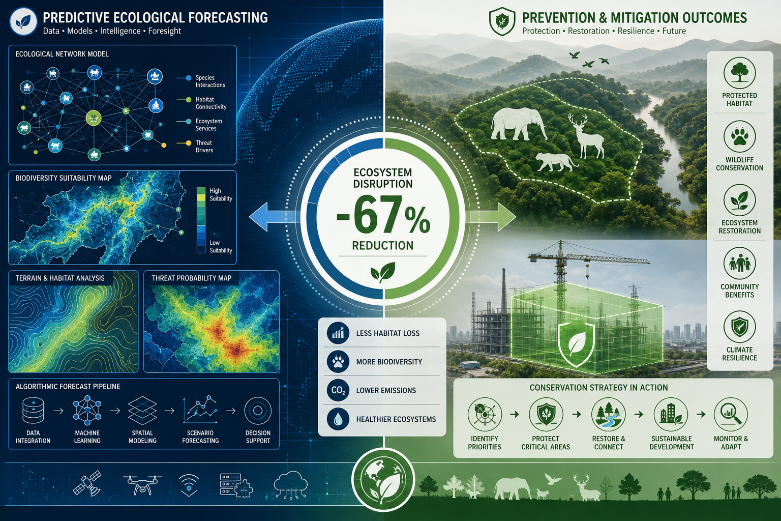
Predictive ecological assessment works differently. Using historical ecological data, climate projections, and land-use change models, forecasters can simulate how a proposed development will alter species distributions, water flows, and habitat connectivity over time. Research published in leading ecology journals confirms that near-term iterative forecasting — where models are continuously updated as new data arrives — produces significantly more accurate and actionable outputs than one-time assessments [9].
"Ecological forecasting is moving from research to operational services akin to weather forecasting — but application to formal EIAs remains uneven." [6]
This unevenness is precisely the opportunity for surveyors who are willing to upskill and integrate these tools into standard practice.
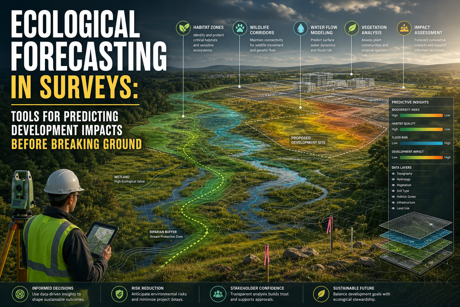
Core Tools Used in Ecological Forecasting for Site Surveys
Understanding which tools underpin ecological forecasting in surveys helps surveyors make informed decisions about what to commission, what to interpret, and what to communicate to clients and regulators.
GIS-Based Habitat and Biodiversity Modelling
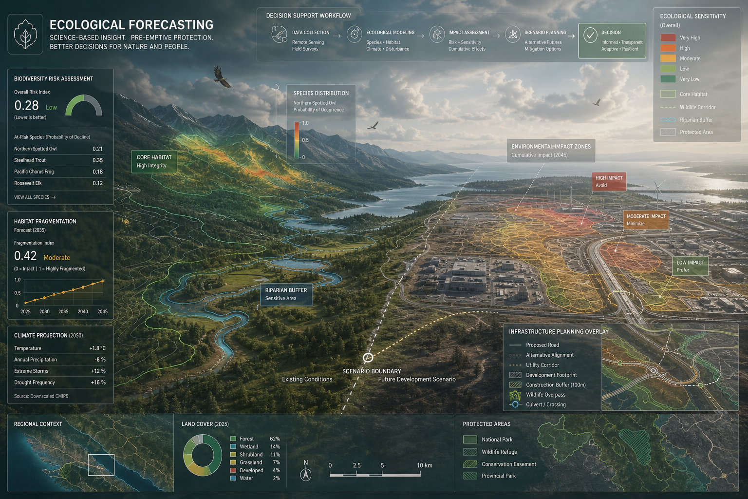
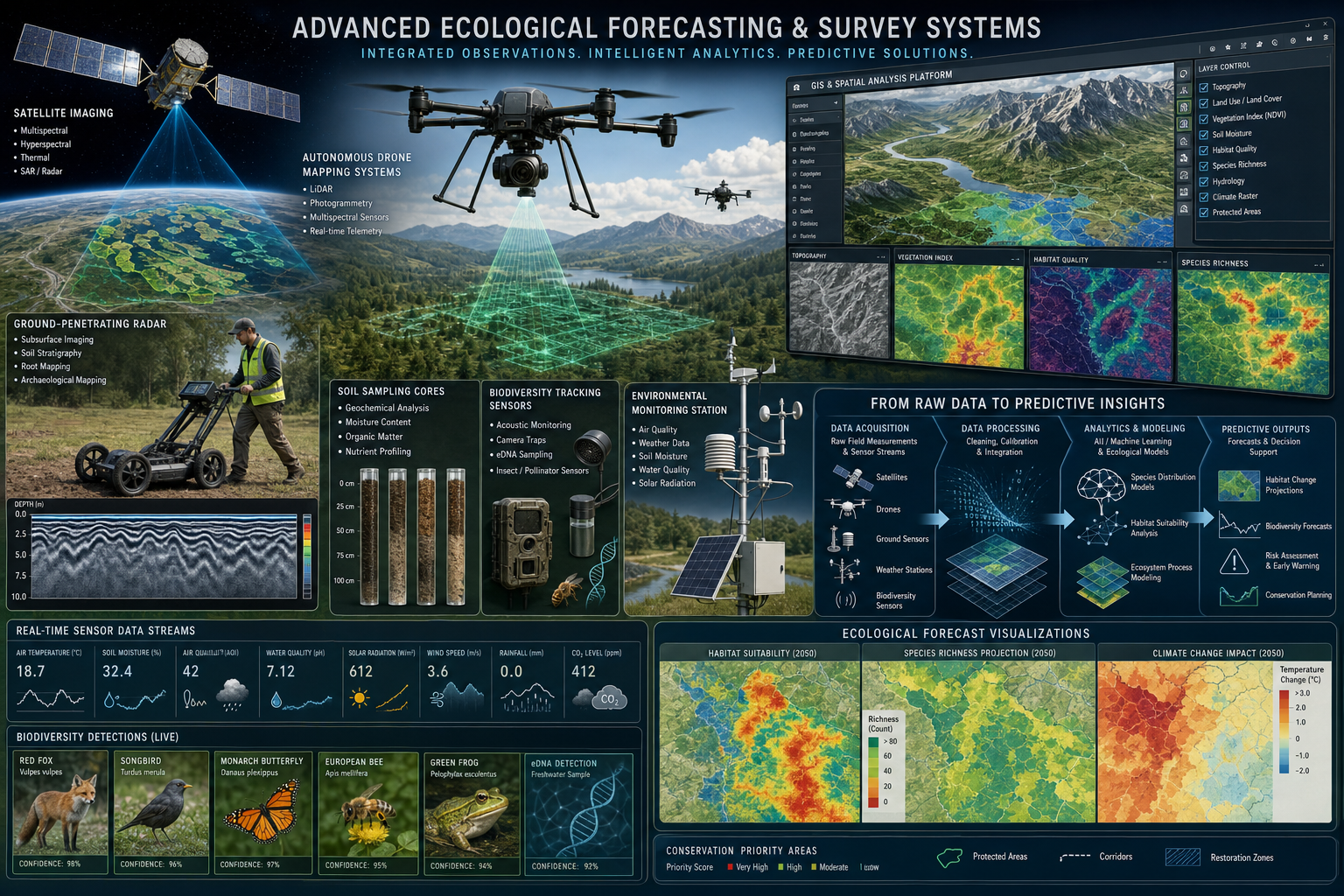
Geographic Information Systems (GIS) form the backbone of most ecological forecasting workflows. By layering spatial data — including soil type, elevation, existing vegetation, watercourse networks, and protected area designations — GIS platforms allow analysts to build detailed ecological baseline maps.
In 2026, GIS tools have advanced significantly. Key capabilities now include:
| GIS Capability | Application in Pre-Development Surveys |
|---|---|
| Species distribution modelling | Predicts where protected species are likely to occur based on habitat suitability |
| Habitat connectivity mapping | Identifies ecological corridors that development may fragment |
| Flood risk spatial analysis | Models how impermeable surfaces will alter local hydrology |
| Change detection using satellite imagery | Tracks vegetation loss and land-use shifts over time |
| Biodiversity Net Gain (BNG) mapping | Quantifies baseline biodiversity units for regulatory compliance |
For UK projects, GIS-based BNG mapping is now particularly critical. The mandatory Biodiversity Net Gain requirement under the Environment Act 2021 means that developers must demonstrate a measurable improvement in biodiversity. GIS tools make this quantifiable and defensible.
Artificial Intelligence and Machine Learning in Ecological Prediction
AI and machine learning have dramatically expanded the predictive power available to ecological forecasters. Where traditional models relied on expert judgment and limited datasets, machine learning algorithms can process vast ecological datasets — including remote sensing imagery, acoustic monitoring data, and citizen science records — to identify patterns and generate probabilistic forecasts.
Key AI applications in pre-development ecological forecasting include:
- Species occurrence prediction: Machine learning models trained on national biodiversity databases can predict the probability of encountering protected species on a given site with far greater accuracy than manual assessment alone.
- Flood and hydrological impact modelling: AI-enhanced hydraulic models simulate how proposed development footprints will alter surface water runoff, groundwater recharge, and flood peak timing.
- Vegetation change simulation: Deep learning models applied to multispectral satellite imagery can forecast how habitat quality will change under different development scenarios.
- Climate-adjusted forecasting: AI models incorporate climate projections to show how ecological conditions on a site may shift over a 10, 25, or 50-year horizon, which is increasingly relevant for long-term infrastructure planning.
The USGS and its partners have formalised ecological forecasting as a decision-support enterprise, including for permitting and environmental review, explicitly recognising that AI-enhanced tools are now mature enough for operational use [5].
Iterative Forecasting and Uncertainty Quantification
One of the most important advances in ecological forecasting is the improved ability to quantify uncertainty. Early ecological models often presented predictions as single-point estimates, which gave a false sense of precision. Modern forecasting frameworks produce probabilistic outputs — ranges of likely outcomes with associated confidence levels [1].
This matters enormously for pre-construction surveys. A planning authority or developer needs to know not just what the most likely ecological outcome is, but what the range of possible outcomes looks like. Forecast horizons — the time period over which a prediction remains reliable — are now better defined, allowing surveyors to present risk estimates that are both honest and defensible [9].
Best-practice standards for building and evaluating ecological forecasts are now widely adopted, enabling more credible impact predictions that can withstand scrutiny in planning appeals and EIA reviews [10].
Applying Ecological Forecasting in Surveys: Tools for Predicting Development Impacts Before Breaking Ground in Practice
Knowing the tools is one thing. Knowing how to integrate ecological forecasting into survey practice — and how to communicate outputs to clients, planners, and green certification bodies — is where professional value is created.
Integration with Standard Survey Workflows
Ecological forecasting does not replace conventional surveys; it enhances them. The most effective approach treats forecasting as a pre-survey planning tool and a post-survey interpretation layer.
A practical workflow might look like this:
- Pre-survey desktop study: Use GIS and national ecological databases to build a preliminary habitat and species risk map for the site. Identify which areas are likely to require detailed field investigation.
- Field survey: Conduct targeted surveys informed by the desktop forecast, focusing resources on high-risk areas identified by the model.
- Post-survey modelling: Feed field survey data back into the forecasting model to refine predictions and produce impact scenarios for different development footprints.
- Scenario comparison: Present planners and clients with a range of development scenarios, each with associated ecological impact forecasts, to support informed decision-making.
- Monitoring plan design: Use forecast outputs to design a post-construction monitoring programme that tests whether predicted impacts materialise as expected.
This iterative approach aligns with the near-term forecasting model now endorsed by major professional bodies [2]. It also produces a documented evidence trail that is invaluable if a planning decision is challenged.
For surveyors working on complex or sensitive sites, understanding what a full building and site survey involves provides important context for where ecological data fits within the broader assessment process.
Supporting Green Building Certifications
In 2026, green building certifications — including BREEAM, LEED, and the UK Green Building Council's net zero frameworks — place increasing weight on ecological performance. Ecological forecasting data directly supports several certification criteria:
- Land use and ecology credits (BREEAM): Forecasting tools help demonstrate that development minimises ecological impact and achieves BNG targets.
- Sustainable sites credits (LEED): Hydrological impact forecasts support stormwater management planning, a key LEED criterion.
- Whole-life carbon assessments: Ecosystem service valuations derived from ecological forecasts contribute to whole-life environmental impact calculations.
Surveyors who can present ecological forecast outputs in a format that directly maps to certification criteria add significant value to development teams. This requires not just technical competence but also clear communication skills.
Communicating Forecast Outputs to Non-Technical Stakeholders
Research on ecological forecasting communication confirms that how outputs are presented is as important as the quality of the underlying model [4]. Planners, developers, and members of the public are not ecologists. They need forecast outputs presented in plain language, with clear visual representations of risk.
Effective communication strategies include:
- Traffic-light risk maps: GIS outputs colour-coded by ecological sensitivity (red, amber, green) are immediately interpretable by non-specialists.
- Scenario comparison tables: Side-by-side tables showing ecological outcomes under different development options help decision-makers understand trade-offs.
- Plain-language uncertainty statements: Instead of statistical confidence intervals, use phrases such as "there is a high likelihood that…" or "under most scenarios, the impact is expected to be…"
- Time-series visualisations: Graphs showing how ecological conditions are predicted to change over 5, 10, and 25 years help clients understand long-term risks.
The EFI's 2026 conference programme explicitly targets improvements in stakeholder communication and visualisation of forecast outputs [7], reflecting how central this challenge has become to the practical uptake of ecological forecasting in planning and development contexts.
Ecological Forecasting and Dilapidations Surveys
There is a growing intersection between ecological forecasting and dilapidations surveys, particularly for commercial properties where lease-end reinstatement obligations may include ecological restoration requirements. Forecasting tools can help quantify the ecological baseline at lease commencement, making it easier to assess the extent of ecological deterioration — and the cost of reinstatement — at lease end.
Similarly, for construction projects, understanding the full scope of construction surveys helps teams identify where ecological forecasting data should be integrated into pre-construction planning documentation.
Regulatory and Professional Body Expectations in 2026
The regulatory landscape for ecological assessment in the UK has tightened considerably. Key developments relevant to surveyors in 2026 include:
- Mandatory Biodiversity Net Gain: All major planning applications must demonstrate a minimum 10% BNG, requiring quantified ecological baseline data.
- Natural England guidance: Updated guidance on protected species licensing now expects applicants to demonstrate that impact assessments are based on robust, up-to-date ecological data.
- RICS professional standards: RICS guidance increasingly references the need for surveyors to engage with ecological specialists and to understand the limitations of ecological data presented in survey reports.
For surveyors seeking to understand how professional standards apply to their survey work, reviewing what a property surveyor's roles and responsibilities involve provides useful grounding. Equally, understanding what surveyors check during inspections helps clarify where ecological data collection fits within the broader inspection framework.
Challenges and Limitations of Ecological Forecasting in Development Surveys
No tool is without limitations, and ecological forecasting is no exception. Surveyors and developers should be aware of the following constraints:
Data quality and availability: Ecological forecasting models are only as good as the data that feeds them. In areas with sparse ecological records, model outputs carry higher uncertainty. Citizen science databases and national recording schemes help, but gaps remain.
Model complexity vs. practical usability: The most sophisticated ecological models require specialist expertise to build and interpret. There is a risk that overly complex outputs are either misunderstood by planners or dismissed as impenetrable.
Temporal limitations: Even the best ecological forecasts carry increasing uncertainty over longer time horizons. Predictions beyond 10-15 years should be treated as indicative rather than precise, particularly in the context of climate change uncertainty.
Application to formal EIAs remains uneven: Despite significant advances, the integration of ecological forecasting into formal Environmental Impact Assessments is still inconsistent across the UK [6]. Some planning authorities are well-equipped to evaluate forecast outputs; others are not.
Cost: Commissioning full ecological forecasting studies — including GIS analysis, AI-enhanced modelling, and scenario development — adds cost to the pre-development phase. This cost must be weighed against the risk of late-stage planning delays or redesign costs.
Conclusion
Ecological forecasting in surveys — as a set of tools for predicting development impacts before breaking ground — is no longer a specialist research activity. In 2026, it is becoming a core component of responsible, efficient, and compliant development practice.
For surveyors, the practical steps are clear:
- Invest in GIS literacy: Even a working knowledge of GIS platforms allows surveyors to interpret and communicate ecological forecast outputs more effectively.
- Build relationships with ecological specialists: Ecological forecasting requires multidisciplinary collaboration. Surveyors who can work fluently with ecologists, hydrologists, and data scientists will deliver better outcomes for clients.
- Integrate forecasting early: The greatest value from ecological forecasting comes when it is commissioned at the earliest stage of site assessment, not as an afterthought after design decisions have been made.
- Communicate clearly: Invest time in translating forecast outputs into plain-language summaries and visual formats that non-specialist stakeholders can act on.
- Stay current with regulatory requirements: BNG obligations, protected species licensing, and green certification criteria are all evolving. Ecological forecasting tools help surveyors stay ahead of these requirements rather than scrambling to meet them.
For those working on new build or development projects, understanding whether a survey is needed on a new build and how to choose the right survey type are important first steps in building a comprehensive pre-development assessment strategy that includes ecological forecasting as a standard component.
The built environment has an unavoidable impact on the natural world. Ecological forecasting gives the professionals who shape that environment the tools to understand, quantify, and minimise those impacts — before the first spade enters the ground.
References
[1] Pmc4676300 – https://pmc.ncbi.nlm.nih.gov/articles/PMC4676300/
[2] The Future Of Ecological Forecasting – https://www.ametsoc.org/ams/about-ams/ams-statements/statements-of-the-ams-in-force/the-future-of-ecological-forecasting/
[4] Cross Cutting Themes – https://ecoforecast.org/cross-cutting-themes/
[5] pubs.usgs.gov – https://pubs.usgs.gov/publication/70274111
[6] Advances In Ecological Forecasting – https://eos.org/editors-vox/advances-in-ecological-forecasting
[7] Efi 2026 Conference – http://www.fields.utoronto.ca/activities/26-27/efi-2026-conference
[8] ecoforecast – https://ecoforecast.org
[9] Pnas – https://www.pnas.org/doi/10.1073/pnas.1710231115
[10] How To Accelerate Advances In Ecological Forecasting – https://eos.org/science-updates/how-to-accelerate-advances-in-ecological-forecasting