
By June 2026, 73% of construction professionals have incorporated Building Information Modelling into their daily workflows — up from just 10% a decade ago [1]. That shift is not accidental. It reflects a hard-won industry consensus: accurate geospatial data, fed directly into BIM models by skilled property surveyors, is one of the most reliable ways to cut costs, reduce errors, and keep projects on schedule.
BIM Integration for Property Surveyors: Enhancing Construction Efficiency with Geospatial Data sits at the heart of this transformation. When surveyors move beyond simply collecting measurements and instead deliver structured, BIM-ready datasets, the entire construction workflow becomes faster, smarter, and far less prone to the expensive conflicts that derail projects. This guide explains how that process works, what technologies drive it, and what practical steps surveyors can take to stay ahead of rising industry demand in 2026.
Key Takeaways
- BIM integration reduces design conflicts by 15-20% and shortens project timelines by 10-20% when geospatial data is accurately fed into models from the outset.
- Modern data capture tools — including LiDAR, UAV photogrammetry, and GNSS receivers — are now essential for producing BIM-ready survey outputs.
- Interoperability standards such as IFC, ISO 19650, and LandXML are critical for seamless data exchange between surveying and BIM platforms.
- Common Data Environments (CDEs) have become the central hub for BIM collaboration, with nearly half of all deployments now running on cloud platforms.
- Surveyors who master BIM workflows are transitioning from data suppliers to strategic project partners, commanding greater influence across the full construction lifecycle.

Why Geospatial Data Quality Determines BIM Outcomes
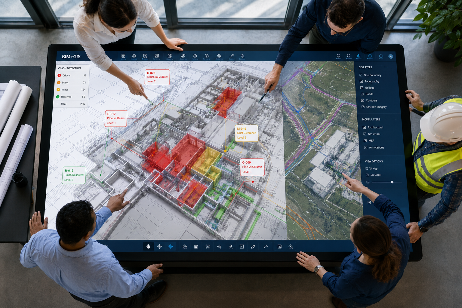
Every BIM model is only as reliable as the survey data that underpins it. Architects and engineers can design with extraordinary precision inside a BIM environment, but if the foundational site data is inaccurate, incomplete, or formatted incorrectly, those designs will not align with physical reality. The result is clashes — conflicts between structural, mechanical, and electrical systems that only surface during construction, when fixing them is most expensive.
Integrating Geographic Information Systems (GIS) and point-cloud data into BIM models has led to a 15-20% decrease in design conflicts before construction begins, directly reducing costly change orders [1]. On one documented mixed-use development, BIM-integrated surveying identified over 200 potential clashes before a single foundation was poured, significantly reducing the need for field modifications [3].
The surveyor's role in this process is foundational. Geospatial data must be:
- Captured at the correct accuracy level for the project stage
- Formatted in standards that BIM platforms can ingest without manual reworking
- Georeferenced correctly so that all disciplines share a common coordinate system
- Delivered through a structured workflow that maintains data integrity from field to model
For surveyors working on complex urban sites, understanding what a construction survey involves — its purpose, types, and best practices — provides the professional baseline from which BIM-ready outputs can be developed.
The Cost of Poor Data Integration
When survey data is delivered in incompatible formats or at insufficient resolution, BIM coordinators must manually clean and reformat it. This introduces errors, delays model development, and undermines the accuracy that BIM is supposed to provide. Projects using poorly integrated geospatial data report higher rates of rework, extended timelines, and inflated material costs — precisely the outcomes BIM is designed to prevent.
BIM users who integrate accurate geospatial data from the start report project timelines that are 10-20% shorter and material cost savings of up to 20% [1]. Those figures represent real money on real projects, and they depend almost entirely on the quality of the surveyor's initial data delivery.
Data Capture Technologies Driving BIM Integration for Property Surveyors: Enhancing Construction Efficiency with Geospatial Data
The tools available to property surveyors in 2026 are substantially more capable than those used even five years ago. The shift toward BIM-ready data capture has been driven by a new generation of instruments that produce outputs directly compatible with BIM platforms.
Core Technologies in Use
| Technology | Primary Output | BIM Application |
|---|---|---|
| Total Stations | Precise 3D point measurements | Control networks, setting out |
| GPS/GNSS Systems | Georeferenced coordinates | Site positioning, boundary surveys |
| Terrestrial Laser Scanning (TLS) | Dense point clouds | Existing conditions, as-built models |
| UAV/Drone Photogrammetry | Aerial point clouds, orthophotos | Site topography, progress monitoring |
| Mobile Mapping Systems | Continuous 3D corridor data | Infrastructure, large-site surveys |
Each of these technologies produces data that, when processed correctly, can be imported into BIM platforms such as Autodesk Revit, Bentley OpenBuildings, or Trimble Connect [2]. The key is understanding which output format each platform requires and ensuring that field capture protocols are designed to meet those requirements from the outset.
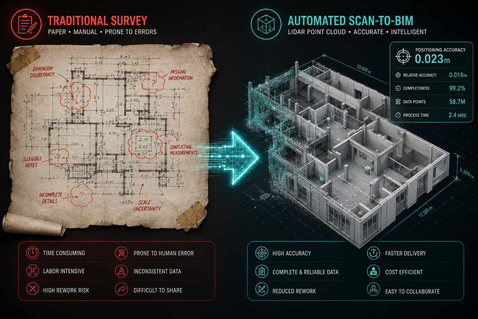
Terrestrial laser scanning deserves particular attention. Modern scanners capture millions of points per second, producing dense point clouds that represent existing structures with sub-centimetre accuracy. When these point clouds are registered and georeferenced correctly, they become the geometric backbone of an as-built BIM model — a process increasingly referred to as Scan-to-BIM.
Recent research has demonstrated the potential of automated Scan-to-BIM pipelines. Systems such as BIMStruct3D combine learning-based semantic segmentation with topology-aware geometric reconstruction, achieving significant improvements over traditional manual methods and demonstrating robustness across varied building types [5]. Separately, research integrating semantic LiDAR point clouds with as-designed BIM models has achieved segmentation accuracies up to 90% and positioning accuracies of 0.023 m for pole-like objects [4] — a level of precision that makes automated urban GeoBIM construction increasingly viable.
UAV photogrammetry has become equally important for large sites and infrastructure projects. Drones equipped with high-resolution cameras and LiDAR sensors can survey extensive areas in a fraction of the time required by ground-based methods, producing georeferenced point clouds and orthophotographic maps that feed directly into BIM site models [3].
For surveyors working on new-build projects, understanding whether a survey is needed on a new build helps frame the baseline data requirements that BIM integration will build upon.
Interoperability Standards: The Invisible Infrastructure
Technology alone is not enough. Data captured in the field must be exchanged between multiple software platforms used by surveyors, architects, structural engineers, and MEP (mechanical, electrical, plumbing) designers. Without agreed standards, each discipline ends up working with incompatible data formats, creating the very silos that BIM is designed to eliminate.
The key interoperability standards governing BIM and geospatial data exchange in 2026 include:
- IFC (Industry Foundation Classes): The open standard for BIM object data exchange, enabling models to move between different software platforms without data loss.
- ISO 19650: The international standard governing the management of information over the whole life cycle of a built asset, including naming conventions, metadata requirements, and workflow protocols.
- LandXML: A widely used format for civil engineering and survey data, including terrain models, alignments, and boundary information.
- E57: The standard format for storing 3D point cloud data from laser scanners, ensuring that scan data can be imported into any compliant BIM platform [2].
Adherence to these standards is not optional on well-managed projects. They are increasingly specified in project briefs and employer's information requirements (EIRs), and surveyors who cannot demonstrate compliance will find themselves excluded from BIM-level contracts.
Common Data Environments and the Future of BIM Integration for Property Surveyors: Enhancing Construction Efficiency with Geospatial Data
The Common Data Environment (CDE) is the platform through which all project information flows in a BIM-compliant project. It provides centralised file storage, version control, approval workflows, and audit trails — ensuring that every member of the project team is working from the same, current data at all times [2].
Approximately 48% of BIM deployments now utilise cloud-based CDE platforms [2], enabling remote collaboration and real-time data access across geographically dispersed project teams. For surveyors, this means that field data captured on site can be uploaded, processed, and made available to the design team within hours rather than days.
"Surveyors proficient in BIM workflows have transitioned from data suppliers to strategic partners, collaborating closely with architects and engineers throughout project lifecycles." [1]
This shift in role is significant. When a surveyor can upload a georeferenced point cloud to a CDE, tag it with the correct metadata, and link it to the relevant BIM model elements, they become an active participant in the design process rather than a passive data provider. That expanded role carries both greater responsibility and greater professional value.
Infrastructure Projects: Where BIM Integration Proves Its Value
Large-scale infrastructure projects have provided some of the clearest evidence of BIM integration's benefits. In highway corridor developments and bridge reconstruction projects, surveyors equipped with BIM-ready GNSS receivers and 3D laser scanning technologies have streamlined data collection and design processes, reducing workflow bottlenecks that previously added weeks to project programmes [3].
The pattern is consistent: when accurate geospatial data is integrated into BIM models from the earliest project stages, the downstream benefits compound. Design teams can identify clashes earlier, quantity surveyors can produce more accurate cost plans, and construction teams can sequence work with greater confidence.
For surveyors involved in structural assessments alongside BIM workflows, structural engineering services provide the technical foundation that BIM models must accurately represent.
Practical Steps for Surveyors Implementing BIM Workflows
Surveyors looking to align their practice with BIM requirements in 2026 should focus on the following areas:
- Invest in compatible hardware: Ensure that total stations, GNSS receivers, and laser scanners produce outputs in formats compatible with the BIM platforms used by target clients.
- Develop software proficiency: Familiarity with point cloud processing software (such as Leica Cyclone, Trimble RealWorks, or Autodesk ReCap) and BIM authoring tools is increasingly expected.
- Understand ISO 19650: The standard governs how information is produced, exchanged, and managed. Surveyors who understand its requirements can position themselves as BIM-compliant partners.
- Engage with CDEs early: Request access to project CDEs at the start of each commission and follow the information delivery plan for naming conventions and upload protocols.
- Build interdisciplinary relationships: BIM integration is fundamentally collaborative. Regular communication with architects, structural engineers, and MEP designers ensures that survey data meets their specific modelling needs.
Understanding what surveyors do across their roles and responsibilities provides useful context for how BIM integration is reshaping professional practice across the sector.
Party Wall and Boundary Considerations in BIM Models
BIM integration does not exist in isolation from the legal and regulatory frameworks that govern property surveying. Accurate boundary data, party wall positions, and existing structure dimensions must be captured and represented correctly in BIM models to avoid disputes and ensure compliance.
When construction work affects shared boundaries, understanding party wall surveyor roles, responsibilities, and legal requirements ensures that BIM models reflect the legal constraints as well as the physical ones. Inaccurate representation of party wall positions in a BIM model can lead to design proposals that breach the Party Wall etc. Act 1996, creating legal complications that no amount of clash detection software can resolve.
Similarly, comprehensive condition survey reports provide the baseline record of existing structures that BIM models must accurately represent — particularly on refurbishment and extension projects where existing conditions directly constrain new design.
Topographic Surveys and BIM Site Models
The topographic survey remains the primary input for BIM site models. Accurate terrain data, drainage features, utility positions, and boundary information must all be captured and delivered in formats that BIM platforms can use to generate accurate site context models.
Understanding topographic survey costs and what they include helps clients and project managers budget appropriately for the level of detail that BIM integration requires. Under-specifying a topographic survey to save cost at the start of a project is a false economy when the resulting data gaps create design conflicts downstream.
Conclusion
BIM Integration for Property Surveyors: Enhancing Construction Efficiency with Geospatial Data is no longer a future aspiration — it is the operational standard that the construction industry expects in 2026. The evidence is clear: accurate geospatial data, delivered in BIM-compatible formats through structured workflows, reduces design conflicts, shortens project timelines, cuts material costs, and elevates the professional standing of surveyors who can deliver it.
Actionable next steps for property surveyors:
- Audit current data capture equipment and software against the interoperability standards (IFC, ISO 19650, LandXML, E57) required by BIM projects.
- Identify skills gaps in point cloud processing and BIM authoring tools, and invest in targeted training.
- Request inclusion in project CDEs from the earliest project stages to ensure survey data is integrated into the design workflow rather than delivered as a standalone output.
- Engage proactively with architects and engineers to understand their specific BIM data requirements before field work begins.
- Position survey services explicitly as BIM-ready in client communications to capture the growing share of projects that mandate BIM compliance.
The surveyors who thrive in this environment will not simply be those who capture the most accurate data — they will be those who deliver that data in ways that make the entire project team more effective.
References
[1] BIM Integration For Land Surveyors Enhancing Construction Efficiency In 2026 – https://kingstonsurveyors.com/bim-integration-for-land-surveyors-enhancing-construction-efficiency-in-2026/?utm_source=openai
[2] BIM Integration For Surveyors Bridging Geospatial Data And Construction Planning – https://nottinghillsurveyors.com/blog/bim-integration-for-surveyors-bridging-geospatial-data-and-construction-planning?utm_source=openai
[3] BIM Integration For Property Surveyors Seamless Collaboration In Modern Construction Projects – https://wimbledonsurveyors.com/bim-integration-for-property-surveyors-seamless-collaboration-in-modern-construction-projects/?utm_source=openai
[4] arxiv – https://arxiv.org/abs/2304.11719?utm_source=openai
[5] arxiv – https://arxiv.org/abs/2604.24311?utm_source=openai