
Boundary disputes account for over 40% of all property litigation cases in the UK courts, yet most could be resolved with proper valuation evidence before reaching trial. When neighbors disagree about property lines, expert witnesses must combine Land Registry data, precise site surveys, and RICS standards to deliver court-ready valuations that withstand cross-examination. As 2026 brings new technological tools—from drone mapping to AI-assisted boundary analysis—surveyors must master integrated strategies that merge traditional documentation with cutting-edge survey techniques.
Understanding Boundary Dispute Valuations: Expert Witness Strategies Integrating Land Registry and Site Surveys has become essential for chartered surveyors, property lawyers, and landowners navigating contentious boundary claims. This comprehensive guide explores proven methodologies, common pitfalls, and emerging technologies that define expert witness practice in boundary valuation disputes.
Key Takeaways
- Land Registry integration forms the foundation of credible boundary valuations, requiring careful analysis of title plans, filed plans, and historical conveyancing documents
- Site surveys using modern technology (total stations, GPS, drones) provide measurable evidence that supports or challenges documentary boundaries
- RICS expert witness standards mandate impartiality, transparency, and robust methodology that can withstand courtroom scrutiny
- Valuation impact assessment quantifies the financial consequences of boundary adjustments, considering land area changes, access rights, and development potential
- 2026 technological advances enable more accurate surveys and compelling visual evidence, but require proper calibration and professional interpretation
Understanding the Foundation: Land Registry Documents in Boundary Dispute Valuations
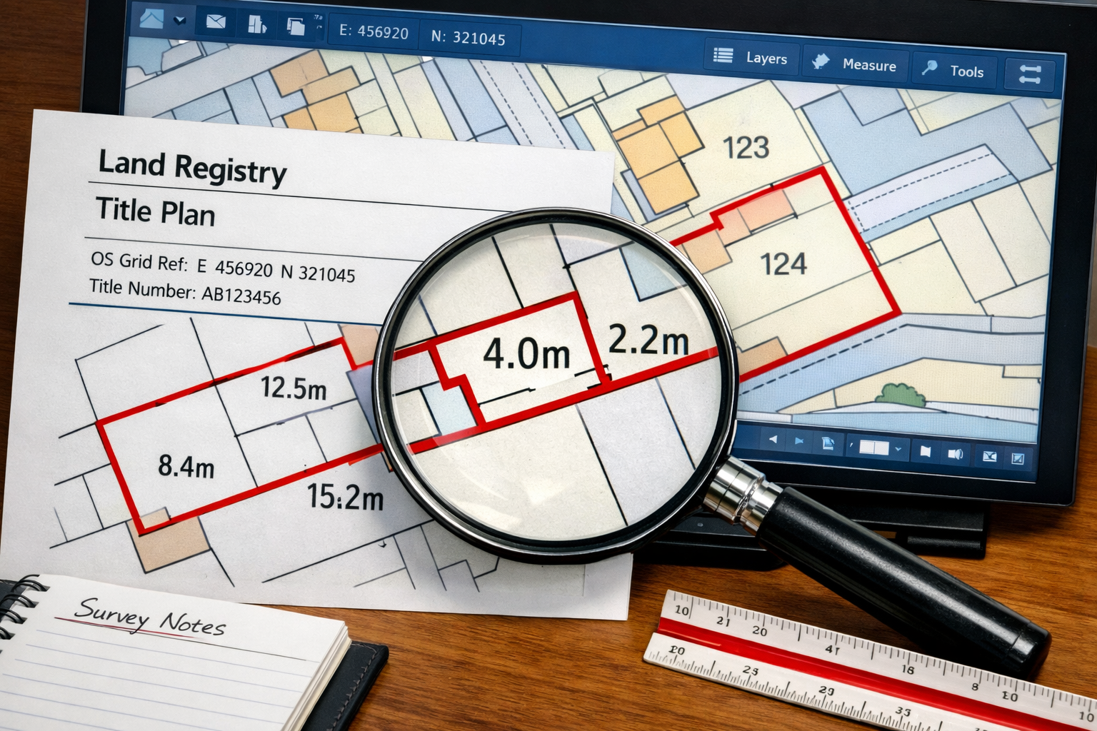
The Role of Title Plans and Filed Plans
Land Registry title plans serve as the primary documentary evidence in most boundary disputes, yet they carry a critical limitation: general boundaries rather than exact boundaries. The Land Registry explicitly states that boundaries shown on title plans are approximate, typically accurate to within 1-2 meters. This inherent imprecision creates the very disputes that require expert valuation.
Expert witnesses must examine multiple documentary sources:
- Title register entries describing property extent and any boundary agreements
- Filed plans showing colored boundaries and reference points
- Historical conveyancing documents including transfer deeds and purchase plans
- Ordnance Survey mapping used as the base for title plans
- Previous survey reports commissioned during earlier transactions
When conducting boundary surveys, professionals must understand that Land Registry plans use Ordnance Survey mapping at 1:1250 scale (urban) or 1:2500 scale (rural). This scale limitation means a 1mm line on the plan represents 1.25 meters on the ground—significant when disputes involve fence positions or building encroachments.
Interpreting Boundary Features and Legal Presumptions
UK property law applies several presumptions when interpreting boundaries:
Hedge and ditch rule 🌳: Where a boundary follows a hedge with an adjacent ditch, the boundary typically runs along the far edge of the ditch from the hedge, presuming the landowner who dug the ditch owned the land and planted the hedge on their side.
Ad medium filum (to the middle line): Boundaries following roads, rivers, or streams typically extend to the centerline unless explicitly stated otherwise.
T-mark ownership: Conveyancing plans often show T-marks indicating which owner maintains boundary features, though these indicate responsibility rather than exact boundary location.
Expert witnesses must research these presumptions and apply them appropriately when Land Registry documents prove ambiguous. This research forms part of the comprehensive valuation factors analysis required for court evidence.
Site Survey Methodologies: Integrating Modern Technology with Traditional Techniques
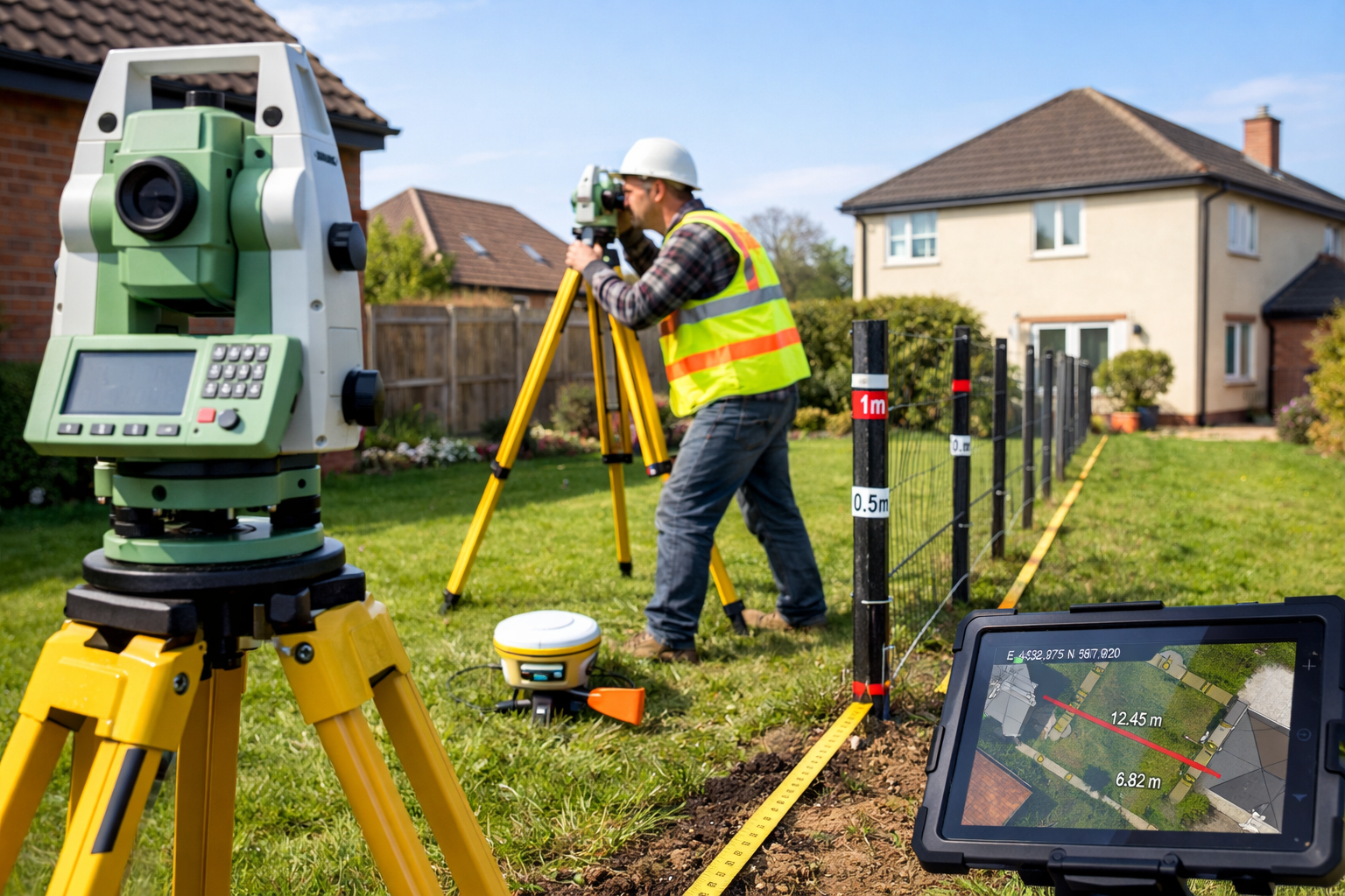
Total Station and GPS Surveys for Precise Measurements
Modern boundary dispute valuations demand millimeter-level accuracy that only professional survey equipment can provide. Total station theodolites measure angles and distances electronically, creating precise coordinates for boundary features, structures, and reference points.
The typical site survey process includes:
- Establishing control points using GPS or known Ordnance Survey benchmarks
- Measuring existing boundary features (fences, walls, hedges, building corners)
- Locating underground services that may indicate historical boundaries
- Documenting encroachments where structures cross disputed boundaries
- Creating scaled survey drawings overlaying measurements on Land Registry plans
GPS technology has advanced significantly, with Real-Time Kinematic (RTK) GPS achieving horizontal accuracy of ±10mm. However, GPS performs poorly under tree canopy or near tall buildings, requiring total station backup in many residential disputes.
According to industry data, boundary surveys typically cost between £300-£1,500 depending on property size and complexity [1]. For expert witness work, more extensive surveys with detailed measurement verification may range from £1,500-£5,000, reflecting the additional documentation and accuracy requirements for court proceedings.
Drone Surveys and Photogrammetry in 2026
Unmanned aerial vehicles (UAVs) have revolutionized boundary dispute evidence collection. Drone surveys capture high-resolution imagery and create 3D models showing boundary relationships from perspectives impossible with ground-based photography.
The 2026 ALTA/NSPS Land Title Survey Standards now explicitly recognize drone-derived data when properly processed and verified [3]. Expert witnesses using drone evidence must ensure:
- ✅ CAA compliance with commercial drone operation regulations
- ✅ Ground control points to georeference aerial imagery accurately
- ✅ Photogrammetric processing creating measurable orthophotos and digital elevation models
- ✅ Metadata documentation proving image capture dates and camera specifications
- ✅ Professional interpretation distinguishing between shadows, vegetation, and actual boundary features
Drone surveys prove particularly valuable for:
- Large rural properties where ground surveys prove time-consuming
- Rear gardens with limited access between neighboring properties
- Historical boundary analysis comparing current conditions with archived aerial photographs
- Demonstrating encroachments visible from above (extensions, outbuildings, hardstanding)
When integrated with Land Registry plans, drone-derived orthophotos create compelling visual evidence that judges and juries readily understand, making complex boundary disputes more accessible to non-technical court participants.
Expert Witness Standards: RICS Requirements and Court Expectations
Professional Duties and Impartiality Requirements
Expert witnesses in boundary disputes serve the court first, not the party instructing them. This fundamental principle, established in Whitehouse v Jordan [1981] and reinforced by Civil Procedure Rules Part 35, requires complete impartiality regardless of who pays the expert's fees.
RICS Practice Statement and Guidance Note on Surveyors Acting as Expert Witnesses mandates:
- Independence: Opinions based solely on professional judgment, not client preference
- Transparency: Disclosing all assumptions, limitations, and uncertainties
- Competence: Only accepting instructions within demonstrated expertise areas
- Compliance: Following court directions and procedural requirements precisely
- Continuing duty: Updating opinions if new evidence emerges before trial
The expert witness must sign a statement confirming understanding of these duties. Failure to maintain impartiality can result in evidence being excluded, costs orders against the expert personally, and RICS disciplinary action.
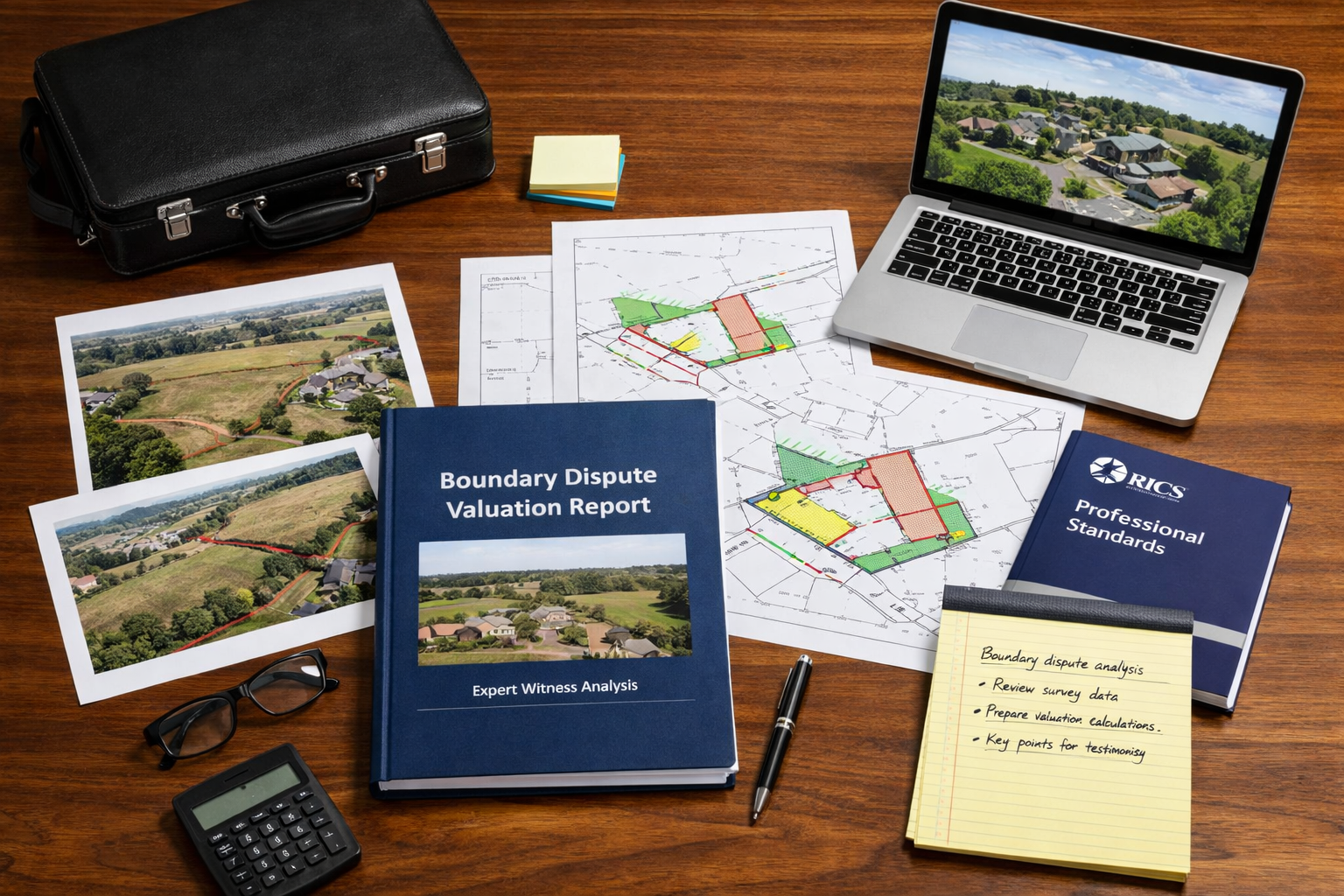
Structuring Expert Reports for Court Proceedings
Court-ready expert reports in boundary dispute valuations follow a structured format that integrates Land Registry analysis and site survey findings:
1. Executive Summary (1-2 pages)
- Dispute overview and key questions addressed
- Primary conclusions and valuation impact
2. Instructions and Scope (2-3 pages)
- Documents provided and site access details
- Specific questions posed by instructing solicitors
- Limitations and assumptions
3. Qualifications and Experience (1-2 pages)
- Professional credentials and RICS membership
- Relevant boundary dispute experience
- Expert witness training and previous court appearances
4. Land Registry Analysis (5-10 pages)
- Title register review and boundary descriptions
- Historical conveyancing document examination
- Legal presumptions applicable to the dispute
- Comparison with Ordnance Survey historical mapping
5. Site Survey Findings (10-15 pages)
- Survey methodology and equipment specifications
- Measured boundary feature locations with coordinates
- Photographic evidence with annotated measurements
- Comparison between physical features and Land Registry plans
- Analysis of any encroachments or discrepancies
6. Valuation Impact Assessment (5-8 pages)
- Land area calculations under different boundary scenarios
- Comparable evidence for land values in the locality
- Impact on development potential, access, or amenity
- Financial quantification of boundary adjustment consequences
7. Conclusions and Opinion (2-3 pages)
- Reasoned opinion on probable boundary location
- Valuation impact summary
- Response to specific questions posed
8. Appendices
- Survey drawings and plans
- Photographs and drone imagery
- Land Registry documents
- Comparable evidence
- Expert's CV and declaration
This structure ensures that Boundary Dispute Valuations: Expert Witness Strategies Integrating Land Registry and Site Surveys are presented logically, allowing judges to follow the reasoning from documentary evidence through site measurements to valuation conclusions.
Valuation Methodologies: Quantifying Boundary Dispute Financial Impact
Land Area Adjustments and Comparative Analysis
The financial impact of boundary disputes depends on multiple factors beyond simple land area calculations. Expert witnesses must consider:
Direct land value impact: If a boundary adjustment transfers 50 square meters of garden land, the valuation requires comparable evidence for similar land sales. In urban areas, garden land might value at £500-£2,000 per square meter depending on location and development potential. Rural agricultural land typically values much lower, from £5,000-£30,000 per acre (approximately £1.25-£7.50 per square meter).
Development potential: Boundary adjustments affecting building plots or extension possibilities create disproportionate value impacts. A 2-meter boundary shift preventing a side extension might reduce property value by £50,000-£150,000, far exceeding the raw land value.
Access and amenity: Boundaries affecting vehicle access, natural light, or privacy carry value implications beyond land area. Expert witnesses must assess these qualitative factors using comparable sales analysis and market evidence.
The valuation approach mirrors principles used in matrimonial valuation and freehold valuation work, requiring detailed market knowledge and transparent methodology.
Quantifying Encroachment and Trespass Damages
When structures encroach across established boundaries, valuation becomes more complex. The expert must assess:
| Encroachment Type | Valuation Consideration | Typical Approach |
|---|---|---|
| Building foundations | Structural implications and removal costs | Cost of underpinning or negotiated easement value |
| Extensions/conservatories | Full structure value and removal/rebuild costs | Diminution in value to affected property + removal costs |
| Fences/walls | Relatively minor but establishes adverse possession timeline | Replacement cost + land value for encroached area |
| Driveways/hardstanding | Access implications and removal disruption | Cost of reinstatement + alternative access provision |
| Trees/landscaping | Root damage potential and amenity loss | Arboricultural assessment + diminution in property value |
The 2026 property market shows significant regional variation [4], requiring experts to adjust valuation approaches based on local market conditions. London and Southeast properties face different valuation dynamics than regional markets, particularly regarding garden land premiums and development potential.
Common Pitfalls and How to Avoid Them
Over-Reliance on Land Registry Plans
The most frequent error in boundary dispute valuations involves treating Land Registry title plans as definitive boundary evidence. They are not. The Land Registry explicitly disclaims boundary precision, yet inexperienced experts sometimes base entire opinions on title plan measurements.
Best practice: Always combine Land Registry documentary evidence with comprehensive site surveys. Where discrepancies exist, explain both sources and provide reasoned opinions on which evidence carries greater weight given the specific circumstances.
Inadequate Historical Research
Boundaries often shift through informal agreements, adverse possession, or simple misunderstanding over decades. Experts who fail to research historical Ordnance Survey maps, aerial photographs, and previous survey reports miss crucial evidence.
Best practice: Obtain historical OS maps from multiple decades, archived aerial photographs (available through various online services), and request previous survey reports from both parties. This historical analysis often reveals boundary evolution and explains current discrepancies.
Measurement Errors and Survey Limitations
Even professional surveys contain measurement uncertainties. Total stations achieve ±2-3mm accuracy under ideal conditions, but vegetation, weather, and equipment limitations introduce errors. Failing to acknowledge these limitations undermines expert credibility.
Best practice: Document survey methodology comprehensively, including equipment specifications, weather conditions, and any access limitations. State measurement tolerances explicitly and explain how uncertainties affect conclusions. When measurements fall within tolerance ranges that could support either party's position, acknowledge this ambiguity rather than claiming false precision.
Ignoring Legal Context and Precedent
Boundary disputes involve legal principles beyond pure surveying. Experts who ignore legal presumptions, adverse possession requirements, or proprietary estoppel principles provide incomplete opinions.
Best practice: Work collaboratively with instructing solicitors to understand the legal framework. While experts must not opine on pure legal questions (that's the judge's role), understanding legal context ensures technical opinions address relevant issues. Consider how party wall disputes and boundary disputes sometimes overlap, requiring coordinated expertise.
2026 Technology Integration: Emerging Tools and Best Practices
AI-Assisted Boundary Analysis
Artificial intelligence tools emerging in 2026 can analyze historical maps, identify boundary feature changes over time, and flag inconsistencies between documentary evidence and site surveys. However, these tools require professional oversight.
Current applications:
- Automated comparison of historical OS maps identifying boundary evolution
- Machine learning algorithms detecting fence lines and boundary features in aerial imagery
- Natural language processing analyzing conveyancing documents for boundary descriptions
- Predictive modeling estimating boundary locations based on multiple evidence sources
Critical limitation: AI tools provide analysis support but cannot replace professional judgment. Expert witnesses remain personally responsible for opinions, regardless of AI assistance used in evidence compilation.
3D Modeling and Virtual Site Visits
Advanced photogrammetry software creates detailed 3D models from drone imagery and ground photographs. These models enable:
- Virtual site inspections by experts, judges, or opposing parties
- Precise measurement extraction from 3D point clouds
- Visual demonstrations of boundary scenarios and encroachment impacts
- Overlay comparisons between proposed boundaries and existing structures
Courts increasingly accept 3D model evidence, particularly when physical site visits prove impractical. However, experts must ensure models meet accuracy standards and provide metadata proving authenticity.
Blockchain-Based Evidence Verification
Some surveyors now use blockchain technology to timestamp and verify survey data, creating tamper-proof evidence chains. While still emerging, this technology may become standard practice for high-value disputes where evidence authenticity might be challenged.
Preparing for Cross-Examination: Strategies for Expert Witnesses
Anticipating Challenges to Methodology
Opposing counsel will scrutinize every aspect of Boundary Dispute Valuations: Expert Witness Strategies Integrating Land Registry and Site Surveys. Common cross-examination lines include:
- Survey accuracy: "How do you know your measurements are accurate to millimeter precision?"
- Selective evidence: "Why did you rely on this document but ignore that one?"
- Assumption validity: "You assumed the fence was built on the boundary—what if it wasn't?"
- Valuation comparables: "These sales aren't truly comparable because…"
- Professional bias: "You've been instructed by the claimant five times—doesn't that affect your impartiality?"
Preparation strategies:
- Document everything: Maintain detailed notes of all site visits, measurements, and analytical steps
- Test alternative scenarios: Consider how different assumptions affect conclusions and be prepared to discuss them
- Know your limitations: Clearly identify what you can and cannot determine with certainty
- Review all evidence: Ensure familiarity with every document in the trial bundle, not just those supporting your opinion
- Practice explaining technical concepts: Use plain language that judges without surveying expertise can understand
Maintaining Professional Credibility Under Pressure
Cross-examination aims to undermine expert credibility. Effective strategies include:
✅ Answer only the question asked: Don't volunteer additional information that opens new attack lines
✅ Admit uncertainties: Acknowledging limitations demonstrates honesty and strengthens credibility
✅ Remain calm and professional: Never become defensive or argumentative regardless of counsel's tone
✅ Correct errors immediately: If you realize you've made a mistake, acknowledge it promptly
✅ Defer to expertise boundaries: If asked about legal interpretation or other professional areas, politely decline and note it exceeds your expertise
The expert's role is assisting the court, not winning for either party. Maintaining this perspective throughout testimony reinforces impartiality and professional standing.
Case Study: Residential Garden Boundary Dispute
Background and Initial Instructions
A typical 2026 boundary dispute involved neighboring semi-detached properties in suburban London. The claimant alleged the defendant's fence encroached 1.5 meters into their garden along a 12-meter boundary length, representing approximately 18 square meters of garden land.
Initial instructions requested:
- Analysis of Land Registry title plans and historical documents
- Comprehensive site survey establishing fence location
- Valuation of disputed land area
- Opinion on probable original boundary location
Integrated Investigation Approach
Land Registry analysis revealed:
- Title plans showed general boundaries only, with typical 1:1250 scale limitations
- No boundary agreement filed or noted on either title register
- Historical conveyancing plans from 1970s showed fence line but without precise measurements
- Both properties derived from 1960s estate development with common developer
Site survey findings:
- Total station survey measured existing fence position with ±3mm accuracy
- Drone survey captured aerial perspective showing fence alignment with other properties
- Ground investigation revealed old fence post holes 1.2 meters from current fence position
- Neighboring properties showed consistent fence line alignment supporting defendant's position
Historical research:
- 1960s estate plan showed intended boundary locations
- Aerial photographs from 1975, 1990, and 2010 showed fence in current position since at least 1975
- Ordnance Survey maps suggested current fence alignment matched original boundary intent
Valuation Impact Assessment
Garden land comparables in the area indicated values of £800-£1,200 per square meter. The disputed 18 square meters represented £14,400-£21,600 in raw land value.
However, the expert identified additional factors:
- Moving the fence would reduce the defendant's garden below typical size for the property type
- The claimant's garden would remain adequate even without the disputed area
- No development potential affected by the boundary position
- 50+ years of fence position suggested adverse possession might apply (legal question, not expert opinion)
Final valuation opinion: The disputed land value ranged from £14,400-£21,600, but practical impact on property values would be minimal (under £10,000 difference) given garden size adequacy for both properties.
Resolution and Lessons Learned
The expert report's balanced analysis, acknowledging uncertainties while providing clear opinions on measurable facts, facilitated settlement negotiations. The parties agreed to maintain the existing fence position with a formal boundary agreement filed at Land Registry.
Key lessons:
- Integrated evidence from multiple sources provides stronger foundations than single-source reliance
- Historical research often proves decisive in long-standing disputes
- Honest acknowledgment of limitations enhances rather than undermines credibility
- Valuation must consider practical market impact, not just mathematical land area calculations
Professional Development and Continuing Competence
RICS Training Requirements for Expert Witnesses
Chartered surveyors providing expert witness services must maintain competence through:
- Formal expert witness training: RICS-accredited courses covering CPR Part 35, report writing, and courtroom procedures
- Continuing professional development: Minimum 20 hours annually, with specific focus on boundary law updates and survey technology
- Peer review participation: Engaging with other experts to review methodology and maintain quality standards
- Court experience: Regular tribunal or court appearances maintaining familiarity with procedural requirements
The surveying profession continues evolving with new technologies and legal precedents. Experts must invest in ongoing education to maintain competence in Boundary Dispute Valuations: Expert Witness Strategies Integrating Land Registry and Site Surveys.
Building Expertise Through Diverse Experience
Competent boundary dispute experts develop expertise across multiple property types and dispute scenarios:
- Residential garden boundaries and fence disputes
- Commercial property boundary conflicts affecting access or development
- Rural land boundaries involving agricultural holdings and access rights
- Riparian boundaries along rivers and streams
- Boundary walls and party wall intersections (see party wall guidance)
- Adverse possession claims requiring historical boundary analysis
Broad experience enables experts to recognize patterns, anticipate challenges, and provide more nuanced opinions when complex disputes arise.
Conclusion: Mastering Integrated Boundary Dispute Valuations
Boundary Dispute Valuations: Expert Witness Strategies Integrating Land Registry and Site Surveys require a sophisticated blend of documentary analysis, technical surveying skills, valuation expertise, and courtroom professionalism. As 2026 brings enhanced survey technologies—from centimeter-accurate GPS to AI-assisted boundary analysis—the fundamental principles remain constant: thorough investigation, impartial analysis, and transparent reporting.
Successful expert witnesses recognize that Land Registry documents provide essential starting points but rarely definitive answers. Comprehensive site surveys using modern equipment create measurable evidence that either supports or challenges documentary boundaries. When these sources conflict, professional judgment informed by historical research, legal presumptions, and physical evidence determines the expert's opinion.
The valuation component extends beyond simple land area calculations to encompass development potential, access implications, and practical market impact. Expert witnesses must quantify these factors using comparable evidence and transparent methodology that withstands cross-examination scrutiny.
Actionable Next Steps for Professionals
For chartered surveyors developing expert witness capabilities:
- Complete RICS-accredited expert witness training and maintain CPD in boundary law
- Invest in modern survey equipment (total station, GPS, drone) and develop proficiency
- Build relationships with solicitors specializing in property disputes
- Seek mentorship from experienced expert witnesses before accepting first instructions
- Maintain detailed records and develop systematic report templates ensuring consistency
For property lawyers instructing experts:
- Select experts with demonstrated boundary dispute experience, not just general surveying credentials
- Provide comprehensive instructions and all available documents from both parties
- Allow adequate time for thorough investigation—rushed reports lack credibility
- Facilitate site access and coordinate with opposing parties' experts for joint inspections where appropriate
- Prepare experts thoroughly for cross-examination, including mock questioning sessions
For property owners facing boundary disputes:
- Engage chartered surveyors early, before disputes escalate to litigation
- Gather all available historical documents, photographs, and previous survey reports
- Consider professional boundary surveys to establish facts before positions harden
- Recognize that expert evidence may not support your position—impartial opinions serve justice
- Evaluate settlement opportunities based on expert valuations rather than pursuing expensive litigation
The integration of Land Registry analysis, modern site surveys, and rigorous valuation methodology creates expert evidence that serves the court's truth-seeking function. As technology advances and professional standards evolve, the core principle remains unchanged: expert witnesses must provide independent, impartial, and thoroughly researched opinions that assist judges in resolving complex boundary disputes fairly.
By mastering these integrated strategies, surveying professionals contribute to efficient dispute resolution, reducing the emotional and financial costs that protracted boundary conflicts impose on property owners. The combination of traditional documentary analysis with cutting-edge survey technology positions expert witnesses to deliver the comprehensive, credible evidence that modern boundary dispute resolution demands.
References
[1] Blog Land Survey Costs 2026 – https://www.thelandgeek.com/blog-land-survey-costs-2026/
[2] Valuation Adjustments For High Value Properties Under 2026 Budget Tax Changes Surveyor Tactics For 2m Thresholds – https://nottinghillsurveyors.com/blog/valuation-adjustments-for-high-value-properties-under-2026-budget-tax-changes-surveyor-tactics-for-2m-thresholds
[3] Watch – https://www.youtube.com/watch?v=5ePOPL5IANs
[4] Building Survey Market Sentiment In Early 2026 Navigating Regional Price Divergence And Buyer Uncertainty – https://nottinghillsurveyors.com/blog/building-survey-market-sentiment-in-early-2026-navigating-regional-price-divergence-and-buyer-uncertainty