
Boundary disputes cost UK property owners an average of £12,000–£35,000 in legal fees when they reach court — yet the single biggest reason cases fail is inadequate site evidence. In 2026, that problem has a measurable solution. Drones in Boundary Dispute Surveys: RICS Evidence Standards for Expert Witness Site Documentation 2026 represent a convergence of aerial technology, professional regulation, and legal admissibility that is fundamentally changing how surveyors document contested land boundaries. This guide explains what those standards require, how drone evidence must be prepared to satisfy CPR Part 35, and why the cost-benefit case for UAV-led boundary surveys is now compelling for both surveyors and property owners.
Key Takeaways 📌
- Drone surveys now meet primary evidence standards under updated RICS and ALTA frameworks, not merely supplementary ones.
- Centimeter-level accuracy from LiDAR-equipped UAVs makes drone data suitable for CPR Part 35 expert witness reports in boundary dispute litigation.
- RICS and CAA compliance is non-negotiable — surveyors must hold correct operator authorisation, risk assessments, and method statements before any flight.
- Cost savings of 40–60% over traditional ground surveys are achievable on complex or large boundary sites, with faster turnaround times.
- Proper metadata, chain of custody, and georeferencing are the critical documentation steps that determine whether drone evidence survives cross-examination.
Why Drone Technology Has Become Central to Boundary Evidence in 2026
For decades, boundary dispute evidence relied on theodolites, tape measures, and OS map overlays — methods that are accurate but slow, expensive, and sometimes physically impossible on steep, overgrown, or access-restricted land. The shift began gradually, but 2026 marks a clear inflection point.
The 2026 ALTA Survey Standard changes formally elevated drones and LiDAR from optional "Table A" supplementary methods to accepted primary methods for data collection within the Minimum Standards framework [3]. While ALTA standards originate in the United States, their influence on international professional bodies — including RICS — reflects a global consensus that UAV-derived data is no longer experimental. It is professional-grade evidence.
RICS has reinforced this position through its published guidance "Drones: applications and compliance for surveyors", which establishes that drone surveying is now "commonplace among the surveying and mapping professions" [5]. The guidance addresses not just operational practice but the legal and regulatory obligations that determine whether drone-collected data can be used in formal proceedings.
For property owners navigating a boundary dispute, this matters enormously. A drone survey conducted to RICS standards, with proper CAA compliance and georeferenced outputs, produces the kind of definitive, court-ready evidence that traditional methods struggle to match [4]. For surveyors preparing expert witness reports, understanding those standards is no longer optional.
💬 "Drone and LiDAR surveys provide definitive, detailed evidence suitable for expert witness documentation and legal resolution of property boundary disputes." — Wimbledon Surveyors, 2026 [4]
Understanding how these surveys fit within the broader landscape of professional property assessments is important. Surveyors already familiar with monitoring surveys and structural engineer reports will recognise that drone-led boundary documentation follows the same principle: precision data, professionally interpreted, presented in a legally defensible format.
RICS Evidence Standards: What Compliance Actually Requires in 2026
Meeting RICS evidence standards for expert witness site documentation is not simply a matter of flying a drone over a property. The regulatory and professional framework is layered, and every layer matters when evidence is tested in court or before a tribunal.
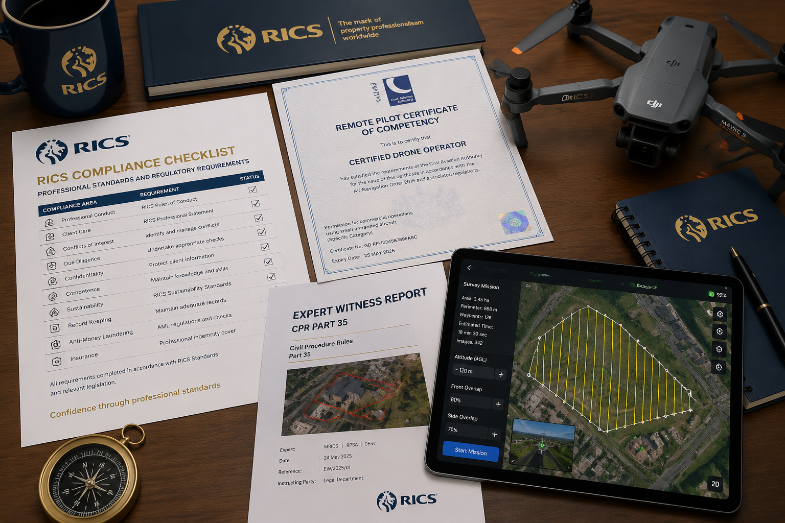
CAA Regulatory Requirements
All drone surveying operations in the UK are governed by CAP393 Air Navigation: The Order and the Regulations (ANO 2016) and CAP722 guidance for unmanned aircraft [5][6]. RICS guidance makes clear that surveyors must:
- Maintain visual line of sight with the drone at all times during flight
- Hold appropriate operator authorisation from the Civil Aviation Authority
- Prepare a risk assessment and method statement before each flight operation
- Ensure the drone pilot holds the required competency certification for the operational category
Failure at any of these points does not just create a safety risk — it creates an evidence risk. Data collected in breach of CAA regulations can be challenged as improperly obtained, potentially rendering an entire expert witness report inadmissible.
CPR Part 35: The Expert Witness Standard
In England and Wales, expert witness evidence in civil proceedings is governed by Civil Procedure Rules Part 35. For drone-derived boundary survey data to satisfy CPR Part 35, the expert witness report must:
| Requirement | What It Means for Drone Evidence |
|---|---|
| Duty to the court | The surveyor's primary obligation is to the court, not the instructing party |
| Objectivity | Drone data must be presented without selective editing or cherry-picking |
| Methodology disclosure | Full details of equipment, flight parameters, and processing software must be stated |
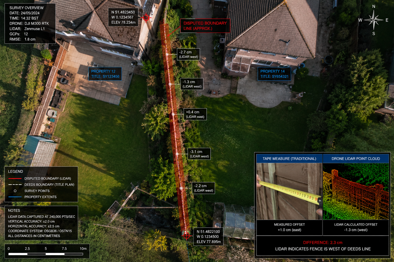
| Accuracy qualification | Stated accuracy levels (e.g., ±15mm) must be supported by ground control point data |
| Chain of custody | Raw data files, timestamps, and metadata must be preserved and available for inspection |
The chain of custody point deserves particular attention. Raw drone imagery and point cloud data must be stored securely with unaltered metadata — including GPS timestamps, altitude records, and camera calibration data. Any post-processing must be documented with version-controlled software logs. This is the difference between drone evidence that holds up under cross-examination and evidence that collapses.
Georeferencing and Ground Control Points
Centimeter-level accuracy — now achievable with 2026 drone and UAV technology incorporating LiDAR and AI processing [7] — is only meaningful if it is independently verifiable. RICS standards require that drone surveys used in boundary dispute documentation include:
- Ground Control Points (GCPs): Physical markers with known coordinates, surveyed using RTK-GPS, placed across the site before flight
- Georeferenced outputs: Orthomosaic images and point clouds tied to the national coordinate system (OSGB36/ETRS89)
- Accuracy reports: Statistical summaries showing root mean square error (RMSE) values for horizontal and vertical accuracy
Without GCPs, a drone survey is essentially floating in space — visually impressive but legally unanchored. With them, the data becomes a precise spatial record that can be directly overlaid on title plan coordinates and OS mapping.
Practical Guide: Running a Drone Boundary Survey That Meets RICS Standards
Drones in Boundary Dispute Surveys: RICS Evidence Standards for Expert Witness Site Documentation 2026 — Step-by-Step
The following workflow reflects current best practice for surveyors preparing drone-based boundary evidence in 2026.
Phase 1: Pre-Flight Planning ✈️
- Review title deeds and Land Registry data — identify the disputed boundary line and any relevant conveyancing documents
- Conduct a site reconnaissance — assess access, obstacles, nearby airspace restrictions, and third-party land implications
- Prepare CAA-compliant documentation — risk assessment, method statement, and operator authorisation confirmation
- Install Ground Control Points — minimum 5 GCPs for sites under 1 hectare; additional GCPs for larger or complex sites
- Survey GCPs with RTK-GPS — record coordinates to millimetre precision
Phase 2: Flight Operations 🚁
- Fly at an appropriate altitude for the required resolution (typically 30–80m AGL for boundary surveys)
- Maintain 80%+ image overlap (forward and lateral) for reliable photogrammetric processing
- Record all flight logs automatically via drone management software
- Keep the drone within visual line of sight at all times [5][6]
Phase 3: Data Processing and Output 💻
- Process imagery using photogrammetry software (e.g., Pix4D, Agisoft Metashape) or LiDAR processing platforms
- Generate: orthomosaic, digital surface model (DSM), point cloud, and contour data
- Produce accuracy report with RMSE statistics
- Preserve all raw data with original metadata intact
Phase 4: Expert Witness Report Preparation 📄
- Present findings in a CPR Part 35-compliant report structure
- Include a clear methodology section covering equipment specifications, flight parameters, and processing workflow
- State accuracy qualifications explicitly
- Attach georeferenced outputs as scaled plans with coordinate annotations
- Provide a signed statement of truth
This process aligns with the broader professional standards that chartered surveyors apply across all high-stakes property assessments. Those working on complex property disputes will find parallels with the rigorous documentation requirements in party wall dispute resolution and subsidence surveys, where evidence quality directly determines outcomes.
Cost-Benefit Analysis: Drone Surveys vs Traditional Ground Surveys for Boundary Disputes
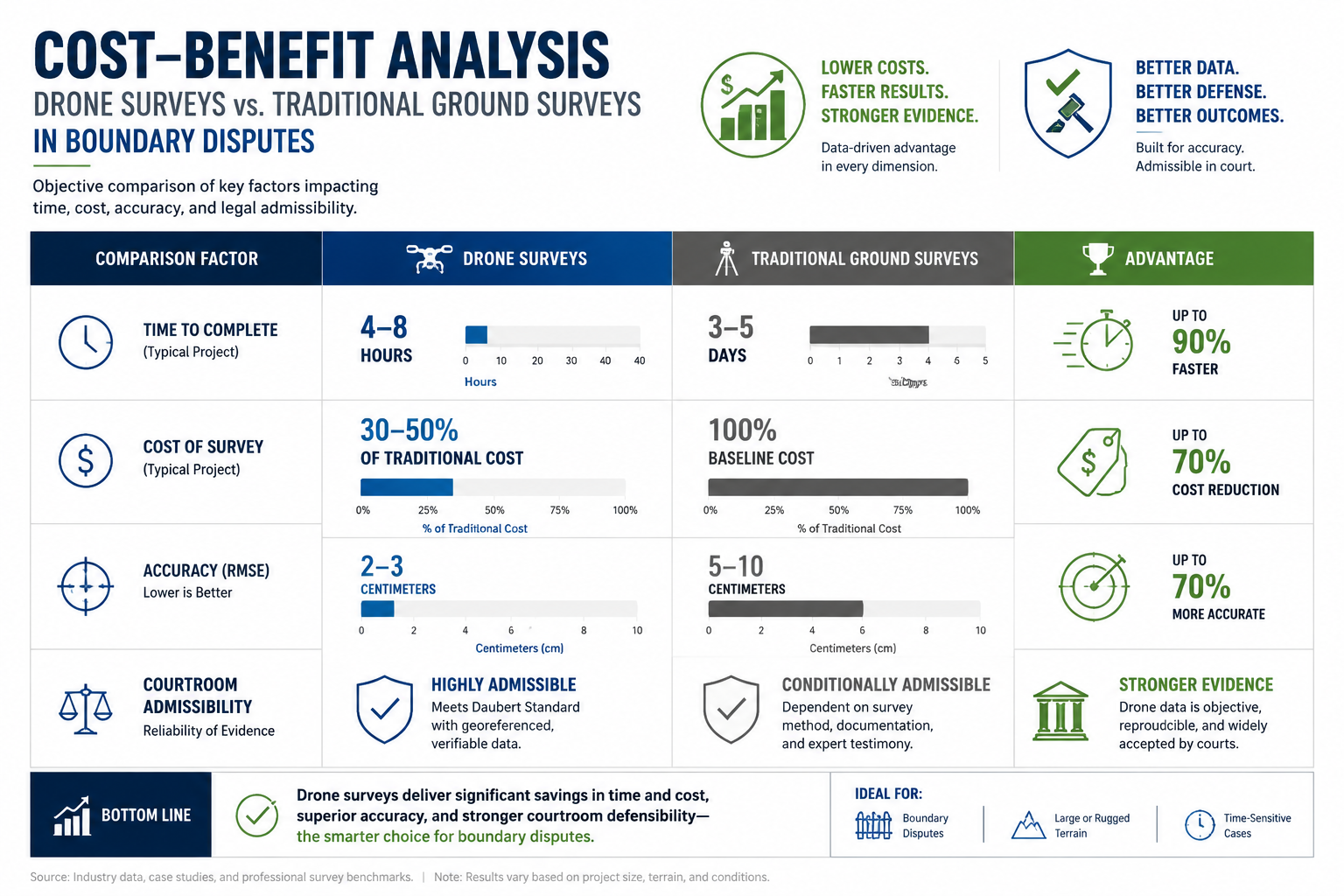
One of the most compelling arguments for adopting drone methodology in boundary dispute work is the economics. RICS documentation recognises multiple operational advantages including the ability to survey large-scale areas and hard-to-reach locations, reduced health and safety risks, minimal operational disruption, and improved data quality [5].
Here is a realistic comparison for a typical residential boundary dispute involving a 0.5-hectare site with access complications:
| Factor | Traditional Ground Survey | Drone Survey (RICS-Compliant) |
|---|---|---|
| Site time | 1–2 days | 2–4 hours |
| Data density | Spot measurements | Full surface coverage |
| Accuracy | ±5–20mm (varies) | ±10–15mm (with GCPs) |
| Access requirements | Physical access to all points | Overfly only (with permissions) |
| Deliverables | Measured survey drawing | Ortho, DSM, point cloud, plans |
| Typical cost | £2,500–£5,000+ | £1,200–£2,800 |
| Report turnaround | 5–10 working days | 2–5 working days |
The cost advantage is significant, but the data quality advantage is arguably more important in a legal context. A drone survey produces a continuous, high-resolution record of the entire site — not a series of discrete measurements. When a barrister asks "what was the condition of the boundary feature at point X?", a georeferenced orthomosaic can answer that question with photographic evidence. A traditional survey drawing cannot.
High-precision GPS and drone surveys are now recognised as primary methods for resolving boundary disputes with detailed evidence documentation [1]. This recognition by legal practitioners — not just surveyors — is what makes the investment in RICS-compliant drone methodology worthwhile.
When Drone Surveys Deliver the Greatest Value 🎯
Drone methodology is particularly advantageous in these boundary dispute scenarios:
- Overgrown or inaccessible boundaries — hedgerows, embankments, watercourses
- Large rural or agricultural sites — where ground survey costs escalate rapidly
- Disputes involving historic encroachment — where vegetation clearance would disturb the evidence
- Multi-party disputes — where a single comprehensive dataset serves all parties
- Appeals and re-examinations — where the original survey is disputed and independent verification is needed
For property owners who are already dealing with the stress of a dispute, understanding the survey process can help. Resources on how local party wall surveyors simplify property disputes in the UK provide useful context on how professional surveyors approach contested boundary situations more broadly.
Regulatory Developments Shaping Drone Boundary Surveys in 2026
The regulatory landscape for drone surveying is evolving rapidly on both sides of the Atlantic, and UK practitioners need to stay current.
UK Framework: CAA and RICS Alignment
RICS published updated evergreen guidance on drone surveys in 2026, combining established professional standards with modern efficiency improvements [2]. The key compliance requirements remain anchored in CAA regulations, but the guidance has been refined to address the growing use of LiDAR-equipped drones and AI-assisted data processing — both of which introduce new considerations for evidence integrity.
Specifically, when AI processing is used to classify point cloud data or identify boundary features automatically, the expert witness report must:
- Identify the AI tools used and their version numbers
- State the confidence thresholds applied to automated classifications
- Confirm that outputs were reviewed and validated by a qualified human surveyor
This last point is critical. AI can accelerate processing enormously, but professional accountability remains human [9]. The surveyor's signature on a CPR Part 35 report means they have personally verified the data — AI assistance does not transfer that responsibility.
International Context: U.S. Regulatory Signals
While UK practitioners operate under CAA/RICS frameworks, it is worth noting that the U.S. is developing a regulatory framework that will allow surveyors to operate larger drone models, expected to become effective in 2026 [8]. Additionally, OMB Memorandum M-26-02 restricts federal agencies from purchasing drones manufactured in China — a development that is influencing equipment procurement decisions internationally [8].
For UK surveyors, the practical implication is straightforward: equipment provenance and data security are becoming part of the compliance conversation. Choosing drones from manufacturers with transparent data handling policies is increasingly relevant when evidence will be used in formal proceedings.
Selecting the Right Drone Equipment for RICS-Compliant Boundary Surveys
Not all survey drones are equal, and equipment selection directly affects the quality and admissibility of evidence. For RICS-compliant boundary dispute work in 2026, the recommended minimum specification includes:
- RTK/PPK GPS capability — for centimeter-level positioning without reliance on GCPs alone
- LiDAR sensor option — for penetrating vegetation canopy and capturing ground-level boundary features [7]
- High-resolution RGB camera — minimum 20MP for photographic evidence quality
- Automated flight logging — timestamped records of all flight parameters
- Encrypted data storage — to support chain of custody requirements
Current leading platforms for professional boundary survey work include multi-rotor systems with integrated RTK modules that deliver horizontal accuracy of ±10mm and vertical accuracy of ±15mm under standard operating conditions [7][10].
The investment in proper equipment pays dividends when evidence is tested. A boundary dispute expert witness report supported by RTK-GPS-verified drone data, with full metadata and GCP verification, is substantially harder to challenge than one based on standard consumer-grade drone imagery.
For surveyors looking to understand how these technical capabilities integrate with broader professional practice, the comprehensive condition survey reports framework provides useful parallels in terms of documentation standards and professional accountability.
Conclusion: Actionable Next Steps for Surveyors and Property Owners
Drones in Boundary Dispute Surveys: RICS Evidence Standards for Expert Witness Site Documentation 2026 represent a mature, court-ready methodology — not a future aspiration. The technology is proven, the regulatory framework is established, and the legal profession is increasingly receptive to UAV-derived evidence when it is properly prepared.
Here are the concrete next steps for each audience:
For Surveyors Acting as Expert Witnesses:
- ✅ Confirm your CAA operator authorisation is current and covers the operational category required
- ✅ Update your standard method statement to reflect 2026 RICS guidance on LiDAR and AI processing
- ✅ Build a GCP deployment protocol into every boundary dispute instruction
- ✅ Establish a secure, version-controlled data archive system for raw drone files
- ✅ Review CPR Part 35 requirements and ensure your report template addresses all mandatory disclosures
For Property Owners in Boundary Disputes:
- ✅ Instruct a RICS-regulated surveyor with specific drone survey competency — not just any drone operator
- ✅ Request confirmation of CAA authorisation and professional indemnity insurance before instruction
- ✅ Ask for georeferenced outputs tied to Land Registry title plan coordinates
- ✅ Understand that the cost of a proper drone survey is a fraction of the legal costs it can prevent
The combination of centimeter-level accuracy, comprehensive site coverage, and legally structured reporting makes drone-led boundary surveys the most cost-effective route to unchallenged expert evidence in 2026. For property owners and surveyors alike, the question is no longer whether to use drone technology — it is whether the drone survey has been conducted to the standard that makes it count.
For further guidance on professional survey standards and property dispute resolution, explore the full range of surveying services and building surveys available from RICS-regulated practitioners.
References
[1] How Technology Drones Gps Is Changing Evidence In Boundary Disputes – https://thebarristersinc.com/news/how-technology-drones-gps-is-changing-evidence-in-boundary-disputes/
[2] Evergreen Rics Guidance On Drone Surveys For Party Wall Assessments 2026 Efficiency Boosts – https://nottinghillsurveyors.com/blog/evergreen-rics-guidance-on-drone-surveys-for-party-wall-assessments-2026-efficiency-boosts
[3] 2026 Alta Survey Standard Changes – https://www.envdesigngroup.com/resources/2026-alta-survey-standard-changes/
[4] Drones And Lidar In Land Surveying 2026 Revolutionizing Accuracy Speed And Cost Efficiency – https://wimbledonsurveyors.com/drones-and-lidar-in-land-surveying-2026-revolutionizing-accuracy-speed-and-cost-efficiency/
[5] Drones And Surveying – https://www.ricsfirms.com/glossary/drones-and-surveying/
[6] Drones Applications And Compliance For Surveyors Rics – https://www.rics.org/content/dam/ricsglobal/documents/to-be-sorted/drones-applications-and-compliance-for-surveyors-rics.pdf
[7] Revolutionizing Land Surveying Key Advancements In Drone And Uav Technology For 2026 – https://kingstonsurveyors.com/revolutionizing-land-surveying-key-advancements-in-drone-and-uav-technology-for-2026/
[8] Watch – https://www.youtube.com/watch?v=CSTodaZb4Vc
[9] Will Ai Replace Human Land Surveyors – https://www.ferris.edu/news/archive/2026/will-ai-replace-human-land-surveyors.htm
[10] Best Drones For Surveying In 2026 Duncan Parnell – https://www.duncan-parnell.com/blog/101/best-drones-for-surveying-in-2026-duncan-parnell