
Nearly 40% of neighbor disputes in the UK stem from boundary disagreements, yet most could be resolved without litigation if proper surveying protocols and expert witness preparation were implemented from the outset. When property boundaries become contested, the role of chartered surveyors transforms from simple measurement to complex legal representation, requiring mastery of RICS standards, court procedures, and Land Registry integration.
Expert witness preparation for boundary disputes: RICS site survey protocols and Land Registry integration represents a specialized field where technical precision meets legal rigor. Professional surveyors must navigate between accurate site measurements, historical document analysis, and courtroom testimony while maintaining strict adherence to Civil Procedure Rules Part 35 and RICS professional standards.
Key Takeaways
- RICS members must complete specific expert witness training before providing evidence in boundary disputes, ensuring compliance with statutory obligations and professional standards [1]
- The Boundary Disputes Protocol requires structured information exchange within four weeks, followed by boundary determination within six weeks based on historical conveyances and Land Registry records [2]
- Expert witness roles range from single joint expert to party-appointed specialist, with clear responsibilities for evidence gathering, measured surveys, and formal court or mediation representation [3]
- Land Registry integration requires precise boundary agreement plans prepared to specific technical standards for official recording and legal confirmation [5]
- Proper expert preparation reduces litigation costs through early mediation, structured protocols, and comprehensive technical documentation [6]
Understanding the Expert Witness Role in Boundary Disputes
The Evolving Standards for Expert Witnesses
The landscape of expert witness preparation has transformed significantly, with RICS introducing mandatory training requirements for members providing expert evidence. According to RICS professional standards, surveyors must undertake specific expert witness training prior to giving expert evidence for the first time, maintaining strict adherence to statutory and court-appointed obligations [1].
This evolution reflects the increasing complexity of boundary disputes in 2026, where traditional surveying skills must be complemented by:
- Legal knowledge of Civil Procedure Rules Part 35
- Court procedure understanding for evidence presentation
- Mediation expertise for alternative dispute resolution
- Historical research capabilities for deed interpretation
- Technical reporting skills for expert opinion documentation
Single Joint Expert vs. Party-Appointed Expert
The civil procedure rules permit use of a single joint expert instructed by both parties to reduce expert evidence costs [3]. This model requires careful consideration of several factors:
Single Joint Expert Benefits:
- ✅ Reduced overall costs for both parties
- ✅ Faster resolution timelines
- ✅ Neutral perspective on technical matters
- ✅ Court preference for cost-effective solutions
Party-Appointed Expert Advantages:
- ✅ Dedicated representation of client interests
- ✅ Detailed case strategy development
- ✅ Comprehensive evidence gathering for one side
- ✅ Strategic advice throughout proceedings
The choice between these approaches must be established early, with clear definition of responsibilities for subject matter, expert evidence scope, and issue presentation [3]. Many boundary surveys begin with attempts at joint expert resolution before escalating to party-appointed specialists.
RICS Professional Standards Compliance
Key compliance requirements include:
| Standard Area | Requirement | Documentation |
|---|---|---|
| Training | Mandatory expert witness course completion | Certificate of attendance |
| Independence | Duty to court over client obligations | Declaration in all reports |
| Competence | Demonstrated boundary dispute experience | CV and case history |
| Ethics | RICS Rules of Conduct adherence | Professional indemnity insurance |
| Reporting | CPR Part 35 compliant expert reports | Standardized report format |
These standards ensure that expert witness preparation for boundary disputes: RICS site survey protocols and Land Registry integration maintains the highest professional quality throughout the legal process.
RICS Site Survey Protocols for Boundary Dispute Evidence
Comprehensive Survey Methodology
Expert boundary work encompasses multiple technical disciplines that extend far beyond simple measurement. According to RICS guidance, comprehensive survey services include evidence gathering, accurate measured surveys, analysis, presentation of results in plans or reports, mediation for both parties, technical expert representation at mediation, and expert witness services [1].
Essential survey components include:
-
Historical Research 📚
- Title deed analysis and interpretation
- Historical conveyance document review
- Previous survey plan comparison
- Ordnance Survey historical map analysis
- Aerial photography timeline examination
-
Physical Site Investigation 🔍
- Precise measurement using total station equipment
- GPS coordinate establishment for boundary markers
- Physical feature documentation (walls, fences, hedges)
- Ground condition assessment
- Photographic evidence collection with scale references
-
Technical Analysis 📊
- Deed description reconciliation with physical features
- Measurement accuracy verification (typically ±5mm for boundary work)
- Historical boundary movement assessment
- Adverse possession consideration
- Encroachment quantification
The Four-Week Information Exchange Protocol
The Boundary Disputes Protocol requires neighbors to exchange sufficient information within four weeks of a dispute arising, ensuring both parties understand each other's position regarding the historical boundary and adjoining land [2]. This structured approach prevents costly litigation by encouraging early resolution.
Week 1-2: Initial Documentation Exchange
- Title plans and deed copies
- Previous survey reports
- Correspondence history
- Photographs of disputed area
- Initial position statements
Week 3-4: Technical Analysis and Response
- Professional survey commissioning
- Historical research completion
- Technical position clarification
- Settlement proposal development
- Mediation consideration
This protocol aligns with broader chartered surveyor responsibilities for professional dispute resolution, emphasizing early intervention over adversarial proceedings.
Six-Week Boundary Determination Requirements
Within six weeks of the initial exchange, parties must summarize discussions and determine whether a boundary exists based on past conveyances, the Land Registration Act 2002, and any existing historic boundary agreements [2]. This timeline creates urgency while allowing sufficient time for thorough technical assessment.
Critical determination factors:
- Legal boundary vs. physical boundary distinction: Understanding that Land Registry plans show general boundaries, not exact legal lines
- Historical conveyance interpretation: Analyzing original deed descriptions and their application to modern surveys
- Occupational evidence: Considering long-term use, maintenance, and adverse possession claims
- Physical monument priority: Recognizing that physical features referenced in deeds take precedence over measurements
- Professional survey accuracy: Ensuring measurements meet RICS standards for boundary determination
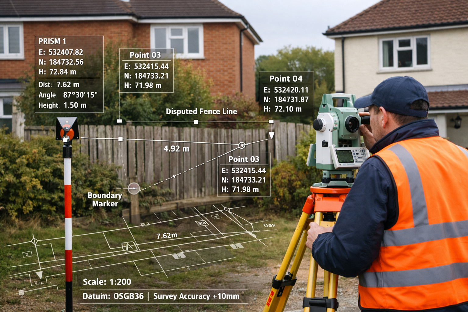
Measured Survey Technical Standards
RICS-compliant boundary surveys must meet rigorous technical specifications:
Accuracy Requirements:
- Horizontal measurement accuracy: ±5mm for boundary points
- Vertical measurement accuracy: ±10mm for level references
- Coordinate system: Ordnance Survey National Grid or local site grid
- Datum establishment: Permanent reference marks with coordinates
- Equipment calibration: Annual certification for total stations and GPS
Documentation Standards:
- Scale: Typically 1:200 or 1:500 for boundary plans
- North arrow and scale bar inclusion
- Coordinate annotation for all boundary points
- Feature key and legend
- Surveyor certification and RICS membership number
These technical standards ensure that expert witness preparation for boundary disputes: RICS site survey protocols and Land Registry integration produces evidence that withstands scrutiny in mediation or court proceedings.
Land Registry Integration and Formal Boundary Agreements
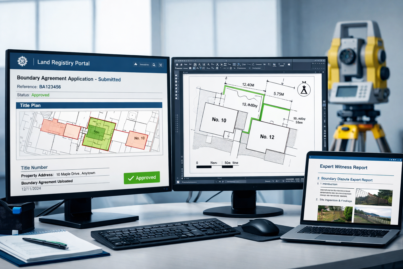
Preparing Plans for Land Registry Submission
Chartered surveyors must prepare plans to required specifications showing the agreed boundary line for formal submission to the Land Registry as a Boundary Agreement, providing official recorded confirmation of the resolved boundary [5]. This integration transforms dispute resolution into permanent legal record.
Land Registry plan requirements:
- Scale specification: 1:1250 for urban areas, 1:2500 for rural properties
- Boundary line depiction: Red line showing exact agreed boundary position
- Title number reference: Clear identification of affected properties
- Measurement annotations: Dimensions from fixed reference points
- Surveyor certification: Professional signature and RICS membership confirmation
- Supporting documentation: Statement of agreed boundary position
The process requires coordination between legal representatives, surveyors, and Land Registry officials to ensure technical compliance and legal validity. Many RICS registered valuers work alongside boundary specialists to provide comprehensive property services during dispute resolution.
Determined Boundary Applications
For disputes requiring maximum certainty, determined boundary applications provide the highest level of Land Registry confirmation. Unlike general boundaries (which show approximate positions), determined boundaries establish exact legal lines with millimeter precision.
Application requirements:
- Detailed survey plan meeting Land Registry technical specifications
- Expert report explaining boundary determination methodology
- Historical evidence supporting the determined position
- Neighbor notification or agreement documentation
- Legal representation for application submission
Processing timeline:
- Initial review: 2-4 weeks
- Objection period: 3 weeks (if neighbors notified)
- Final determination: 8-12 weeks total
- Registration completion: 2-4 weeks after approval
Expert Witness Qualification Verification
When selecting an expert for boundary disputes, clients should verify they specialize in boundary work, have experience with mapping and land surveys, can interpret aerial photographs, understand current civil procedure rules, and have documented court experience as an expert witness [5].
Essential qualifications checklist:
✅ Professional Status
- RICS membership (MRICS or FRICS)
- Specialist boundary dispute experience (minimum 5 years)
- Professional indemnity insurance (minimum £1 million)
- Expert witness training certification
✅ Technical Competencies
- Total station and GPS survey equipment proficiency
- CAD software expertise for plan production
- Historical map and deed interpretation skills
- Aerial photography analysis capabilities
- Land Registry application experience
✅ Legal Knowledge
- CPR Part 35 compliance understanding
- Court procedure familiarity
- Mediation process experience
- Evidence presentation skills
- Cross-examination preparation
✅ Track Record
- Previous expert witness appointments
- Successful boundary dispute resolutions
- Published reports or case studies
- Professional references from solicitors
- Court or tribunal testimony experience
This comprehensive qualification framework ensures that expert witness preparation for boundary disputes: RICS site survey protocols and Land Registry integration maintains professional standards throughout the legal process.
The Boundary Disputes Mediation Service (BDMS)
Launched in November 2020, RICS and the Property Litigation Association (with Civil Justice Council endorsement) established the Boundary Disputes Mediation Service as a structured alternative to court proceedings [1]. This service represents a significant advancement in dispute resolution methodology.
BDMS advantages:
- Cost reduction: Typically 60-80% less expensive than litigation
- Time efficiency: Resolution in weeks rather than months or years
- Relationship preservation: Less adversarial than court proceedings
- Expert involvement: Technical specialists participate in mediation
- Flexible outcomes: Creative solutions beyond court-imposed remedies
Mediation process structure:
- Initial application with dispute summary
- Mediator appointment (often with surveying expertise)
- Pre-mediation exchange of technical reports
- Mediation session (typically one day)
- Settlement agreement or further negotiation
- Land Registry submission of agreed boundary
The BDMS framework integrates seamlessly with building surveys and other property assessment services, creating comprehensive solutions for property owners facing boundary uncertainties.
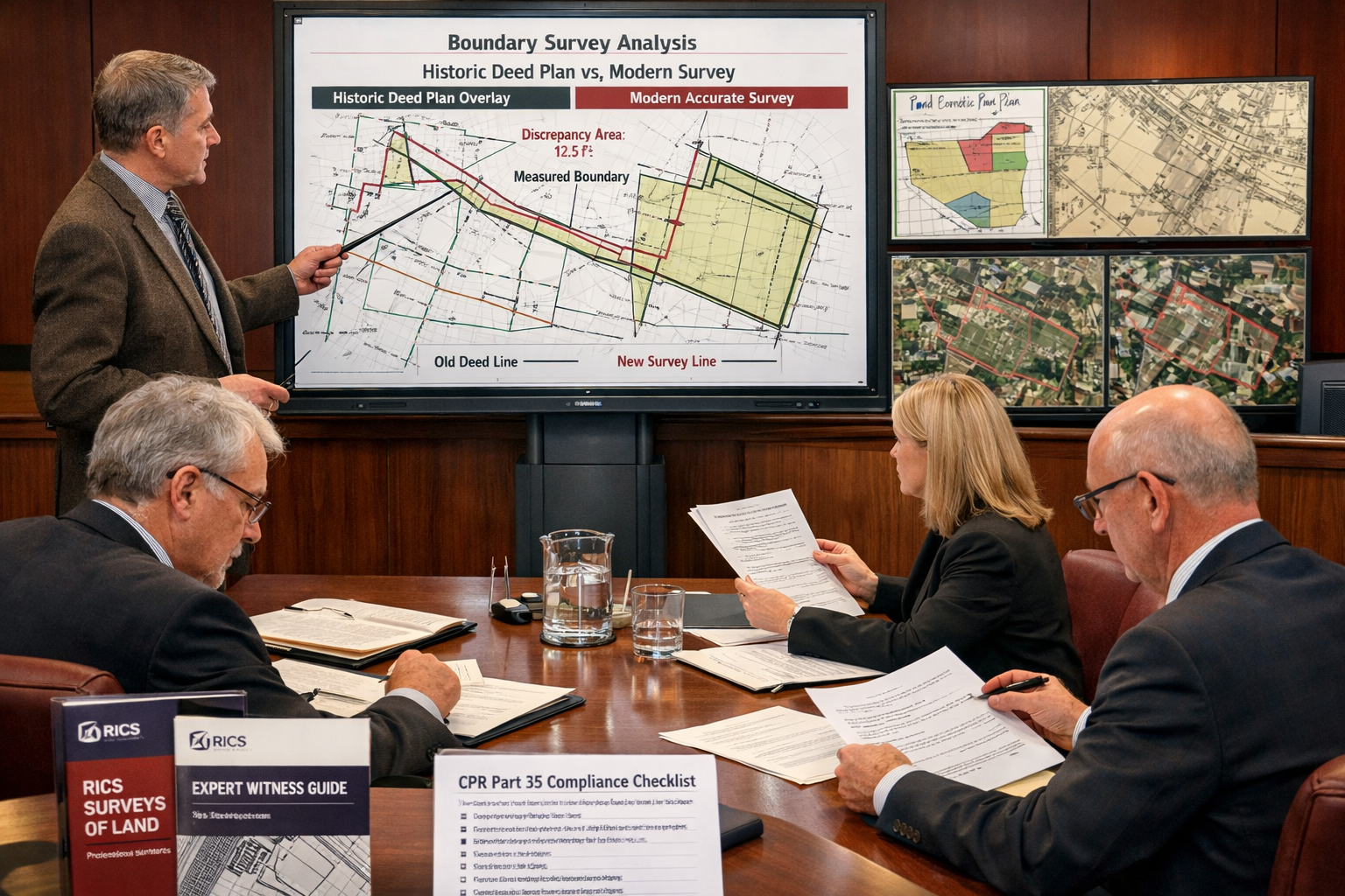
Expert Report Preparation and Court Compliance
CPR Part 35 Requirements for Expert Reports
Expert reports must comply with strict Civil Procedure Rules Part 35 requirements, ensuring independence, objectivity, and comprehensive technical analysis. The expert's duty to the court supersedes any obligation to the instructing party [3].
Mandatory report sections:
-
Expert qualifications and experience
- Professional credentials
- Relevant case history
- Specialist boundary expertise
- Training and certifications
-
Instructions received
- Questions to be addressed
- Documents reviewed
- Site inspection details
- Limitations or constraints
-
Factual investigation
- Historical research findings
- Survey methodology and results
- Physical evidence documentation
- Photographic records
-
Technical analysis
- Deed interpretation
- Measurement reconciliation
- Historical boundary assessment
- Alternative scenarios consideration
-
Expert opinion
- Boundary position conclusion
- Confidence level statement
- Alternative interpretations
- Limitations and assumptions
-
Declaration of truth
- Statement of independence
- Duty to court acknowledgment
- Compliance with CPR Part 35
- Expert signature and date
Evidence Gathering and Documentation
Comprehensive evidence collection forms the foundation of effective expert witness preparation. The quality and breadth of documentation directly impact case outcomes.
Documentary evidence categories:
📄 Historical Documents
- Original title deeds and conveyances
- Previous survey plans and reports
- Ordnance Survey historical editions
- Aerial photography sequences
- Planning application documents
📷 Photographic Evidence
- Current site conditions with scale references
- Historical photographs showing boundary features
- Aerial imagery comparison timelines
- Detailed feature close-ups
- Seasonal variation documentation
📐 Technical Measurements
- Total station survey data
- GPS coordinate records
- Dimension verification measurements
- Level surveys for boundary features
- Equipment calibration certificates
📊 Analytical Reports
- Deed interpretation analysis
- Historical research summaries
- Measurement reconciliation tables
- Adverse possession assessments
- Encroachment calculations
This comprehensive approach to evidence gathering supports the broader work of structural surveys and property assessments, ensuring all technical aspects receive proper attention.
Cross-Examination Preparation
Expert witnesses must prepare thoroughly for cross-examination, anticipating challenges to methodology, conclusions, and professional qualifications. Effective preparation includes:
Preparation strategies:
- Report mastery: Complete familiarity with every statement and measurement
- Alternative scenarios: Understanding opposing expert positions
- Methodology defense: Clear explanation of survey techniques and standards
- Assumption clarity: Transparent acknowledgment of limitations
- Professional composure: Maintaining objectivity under pressure
Common cross-examination topics:
- Measurement accuracy: Challenging survey precision and equipment calibration
- Historical interpretation: Questioning deed analysis and document conclusions
- Professional experience: Testing qualifications and relevant case history
- Methodology selection: Examining survey approach and technical choices
- Alternative conclusions: Exploring other possible boundary positions
Understanding these challenges helps surveyors provide robust, defensible expert opinions that withstand legal scrutiny while maintaining RICS professional standards.
Cost Considerations and Value Optimization
Expert Witness Fee Structures
Professional fees for expert witness services in boundary disputes vary based on complexity, urgency, and required expertise. Understanding cost structures helps clients budget appropriately and optimize value.
Typical fee components:
| Service Element | Typical Range | Factors Affecting Cost |
|---|---|---|
| Initial consultation | £250-£500 | Complexity, travel distance |
| Site survey | £1,500-£3,500 | Property size, access issues |
| Historical research | £500-£1,500 | Document availability, archive access |
| Expert report | £2,000-£5,000 | Detail level, urgency, complexity |
| Mediation attendance | £1,500-£3,000/day | Preparation time, travel |
| Court attendance | £2,500-£5,000/day | Preparation, cross-examination |
Value optimization strategies:
- Early expert involvement: Preventing costly litigation through early technical assessment
- Single joint expert consideration: Sharing costs between parties where appropriate
- Mediation prioritization: Resolving disputes before court proceedings
- Comprehensive initial survey: Avoiding multiple site visits through thorough first investigation
- Clear instructions: Reducing unnecessary work through precise scope definition
These cost considerations complement the broader financial planning required for property transactions, similar to understanding party wall surveyor costs for adjacent property work.
Return on Investment Analysis
While expert witness services represent significant investment, the cost-benefit analysis strongly favors professional involvement:
Potential savings from expert involvement:
- Litigation cost avoidance: £10,000-£50,000+ in legal fees
- Property value protection: Preventing devaluation from unresolved disputes
- Time savings: Months or years of dispute resolution
- Relationship preservation: Maintaining neighbor relations through professional mediation
- Future certainty: Preventing recurring disputes through formal boundary determination
Risk mitigation value:
Professional expert witness preparation provides insurance against adverse outcomes, protecting property rights and financial interests through technical rigor and legal compliance.
Practical Implementation: Case Study Approach
Residential Boundary Dispute Resolution
Scenario: Two neighboring properties dispute a fence line position, with historical deeds providing ambiguous boundary descriptions.
Expert witness approach:
-
Week 1-2: Historical research and document analysis
- Title deed review for both properties
- Ordnance Survey historical map comparison
- Previous survey plan identification
- Aerial photography timeline analysis
-
Week 3: Comprehensive site survey
- Total station measurement of existing fence
- GPS coordinate establishment
- Physical feature documentation
- Photographic evidence collection
-
Week 4: Technical analysis and reporting
- Deed description reconciliation
- Measurement comparison with historical plans
- Boundary position determination
- Expert report preparation
-
Week 5-6: Mediation and resolution
- Pre-mediation exchange of reports
- Mediation session attendance
- Settlement agreement negotiation
- Land Registry boundary agreement submission
Outcome: Successful resolution through mediation, with formal boundary agreement registered at Land Registry, total cost £8,500 compared to estimated £35,000+ for litigation.
Commercial Property Boundary Determination
Scenario: Commercial development requires precise boundary determination for planning compliance and neighbor rights protection.
Expert witness methodology:
- Determined boundary application for maximum legal certainty
- Comprehensive survey to Ordnance Survey National Grid coordinates
- Neighbor consultation and agreement negotiation
- Land Registry submission with expert supporting documentation
- Planning authority coordination for development approval
This approach demonstrates how expert witness preparation for boundary disputes: RICS site survey protocols and Land Registry integration creates value across residential and commercial contexts.
Future Trends and Professional Development
Emerging Technologies in Boundary Surveying
The surveying profession continues to evolve with technological advancement, creating new opportunities for precision and efficiency:
Current innovations:
- Drone aerial surveys: High-resolution imagery and photogrammetry for boundary analysis
- 3D laser scanning: Detailed feature capture and historical comparison
- AI-assisted deed interpretation: Machine learning for historical document analysis
- Blockchain boundary records: Immutable recording of boundary agreements
- Virtual reality court presentations: Enhanced evidence visualization for judges and mediators
Continuing Professional Development Requirements
RICS members must maintain ongoing professional development to ensure current knowledge of standards, technology, and legal requirements. For 2026, this includes:
CPD focus areas:
- Expert witness training updates and refresher courses
- New Land Registry digital submission protocols
- Advanced surveying technology proficiency
- Mediation and alternative dispute resolution skills
- CPR Part 35 compliance and recent case law
Professional resources:
- RICS boundary dispute guidance documents [1]
- Expert witness practice standards [3]
- Land Registry technical specifications [5]
- Professional networking and case study sharing
- Court procedure updates and legal developments
This commitment to professional excellence ensures that expert witness preparation maintains the highest standards while adapting to evolving legal and technical landscapes.
Conclusion
Expert witness preparation for boundary disputes: RICS site survey protocols and Land Registry integration represents a specialized professional discipline requiring technical precision, legal knowledge, and ethical commitment. The structured approach outlined in this guide—from initial survey methodology through Land Registry integration—provides property owners, legal professionals, and surveyors with a comprehensive framework for effective dispute resolution.
The key to successful boundary dispute resolution lies in early professional involvement, rigorous technical standards, and commitment to mediation over litigation. By following RICS protocols, complying with CPR Part 35 requirements, and leveraging the Boundary Disputes Mediation Service, parties can achieve cost-effective, timely resolution while maintaining professional relationships and property values.
Actionable Next Steps
For property owners facing boundary disputes:
- Engage a qualified RICS surveyor with demonstrated boundary dispute expertise and expert witness experience
- Comply with the four-week information exchange protocol to facilitate early resolution
- Commission a comprehensive boundary survey meeting RICS technical standards
- Consider mediation through BDMS before pursuing litigation
- Pursue formal Land Registry boundary agreement for long-term certainty
For surveyors developing expert witness capabilities:
- Complete mandatory expert witness training before accepting first appointment
- Develop comprehensive boundary survey methodology incorporating historical research and precise measurement
- Master CPR Part 35 requirements for expert report preparation
- Build mediation and court presentation skills through continuing professional development
- Maintain current knowledge of Land Registry procedures and technical specifications
The investment in professional expert witness preparation delivers substantial returns through dispute resolution efficiency, cost reduction, and long-term property certainty. As boundary disputes continue to challenge property owners and legal professionals, the role of qualified RICS surveyors as expert witnesses becomes increasingly vital to the effective administration of property justice.
For comprehensive property assessment services including boundary surveys, professional guidance, and expert witness support, consulting with experienced chartered surveyors provides the foundation for successful dispute resolution and property rights protection.
References
[1] Boundaries procedures for boundary identification demarcation and dispute resolution October 2022 – https://www.rics.org/content/dam/ricsglobal/documents/standards/Boundaries%20procedures%20for%20boundary%20identification_%20demarcation%20and%20dispute%20resolution_October%202022.pdf
[2] Boundary Disputes Protocol – https://hardingsurveyors.co.uk/party-wall-matters/boundary-disputes-protocol
[3] Surveyors acting as expert witnesses Feb2023amend – https://www.rics.org/content/dam/ricsglobal/documents/standards/Surveyors%20acting%20as%20expert%20witnesses_Feb2023amend.pdf
[4] Boundaries Procedures For Boundary Identification Demarcation And Dispute Resolution 3rd Edition Rics – https://martinsurveying.co.uk/wp-content/uploads/2019/09/boundaries-procedures-for-boundary-identification-demarcation-and-dispute-resolution-3rd-edition-rics.pdf
[5] Rics Consumer Guide Boundary Disputesv2 – https://www.ricsfirms.com/media/1214/rics-consumer-guide-boundary-disputesv2.pdf
[6] Surveyors Acting As Expert Witnesses Client Guide – https://www.rics.org/content/dam/ricsglobal/documents/standards/Surveyors_Acting_As_Expert_Witnesses_Client_Guide.pdf
[7] Expert Witness Essentials For 2026 Boundary Disputes Strengthening Cases In A Recovering Property Market – https://nottinghillsurveyors.com/blog/expert-witness-essentials-for-2026-boundary-disputes-strengthening-cases-in-a-recovering-property-market