
As the property market shows signs of recovery in 2026, buyer enquiries are increasing and competition among surveyors has never been fiercer. In this evolving landscape, Building Survey Digital Reporting: Visual Documentation and Client Communication in a Recovering Market has emerged as the critical differentiator separating forward-thinking firms from those still relying on traditional methods. Clients no longer accept static PDF reports with grainy photographs—they expect interactive 3D models, annotated thermal imaging, and instant access to comprehensive visual documentation that helps them make confident property decisions. 📊
The transformation is profound: surveyors who embrace advanced digital reporting tools aren't just improving efficiency—they're fundamentally reshaping client expectations and experiences. From cloud-based collaboration platforms to AI-enhanced defect detection, the technology available in 2026 enables surveying firms of all sizes to deliver exceptional value while streamlining their workflows. This shift represents both an opportunity and a necessity as the market recovers and clients become increasingly discerning about which professionals they trust with their property investments.
Key Takeaways
- Digital reporting tools with 3D visualization and annotated photography create significant competitive advantages in the recovering 2026 market, improving client satisfaction and differentiation
- Cloud-based platforms enable instant collaboration and real-time communication, transforming surveys from static documents into interactive, ongoing client relationships
- Visual documentation serves as a foundation for lifecycle asset management, creating recurring revenue opportunities beyond traditional one-time survey engagements
- Client expectations have permanently shifted toward rich digital deliverables, with surveys now expected to integrate seamlessly into broader property management and BIM workflows
- Implementation barriers have lowered substantially, making reality capture and digital reporting accessible to surveying firms of all sizes, not just large enterprises
The Evolution of Building Survey Reporting in 2026
From Paper to Pixels: The Digital Transformation Journey
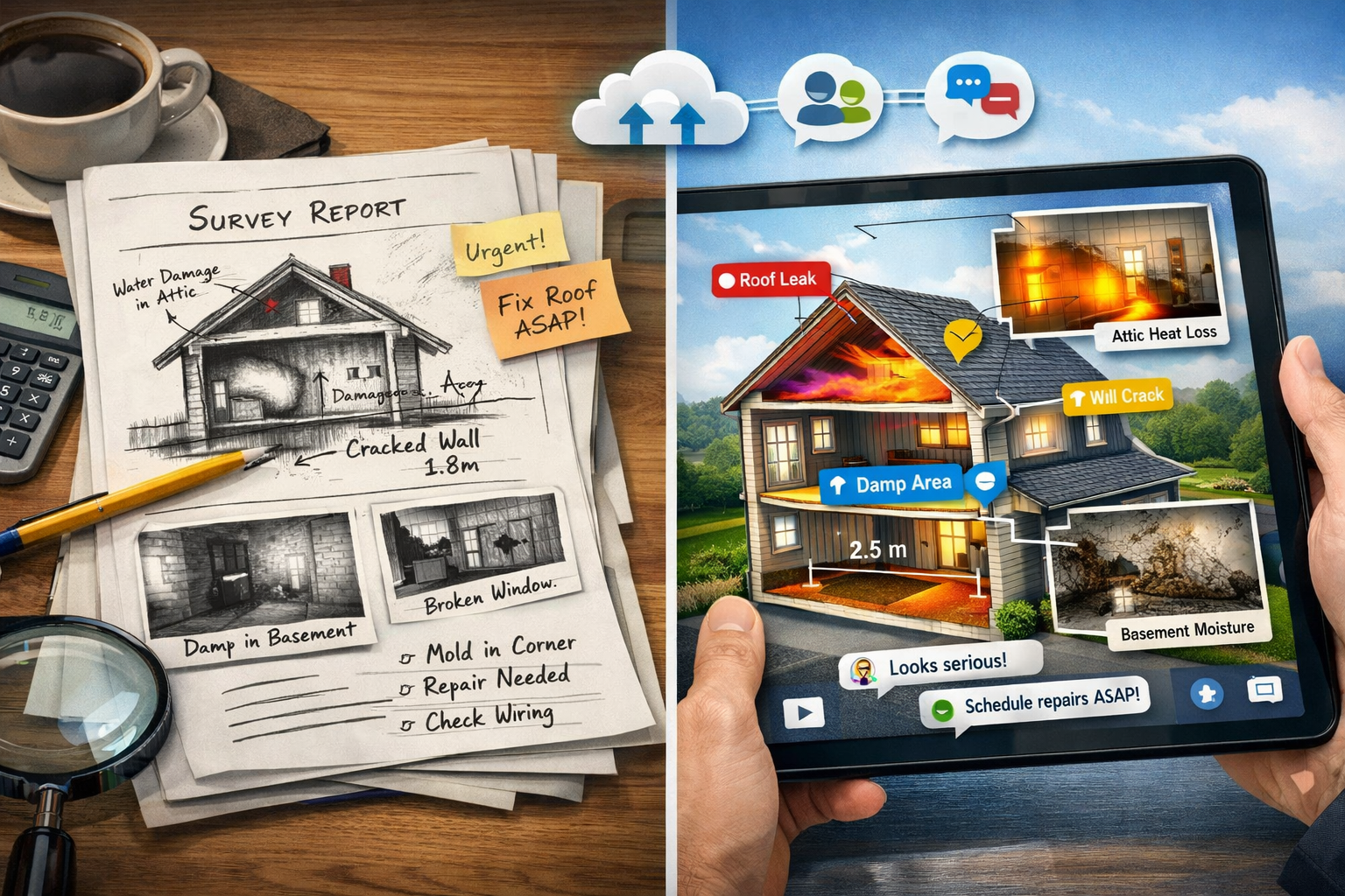
The surveying profession has undergone a remarkable transformation over the past decade. Traditional building surveys once consisted primarily of typed reports with accompanying photographs printed on glossy paper, delivered weeks after site visits. These static documents served their purpose but offered limited interactivity and often left clients with more questions than answers.
In 2026, the landscape looks dramatically different. Reality capture technology has evolved from a specialized service requiring substantial capital investment to an increasingly accessible toolset that surveying firms of all sizes can now deploy.[1] User-friendly tools and broader platform support are making implementation easier for firms across the market, democratizing access to advanced capabilities that were once the exclusive domain of large enterprises.
This democratization has fundamentally altered client expectations. Today's property buyers—many of whom are digital natives or have become accustomed to sophisticated technology in other aspects of their lives—expect the same level of digital sophistication from their surveying professionals. They want to explore properties virtually, zoom into specific defects, and understand repair priorities through visual hierarchies rather than dense paragraphs of technical text.
The Competitive Imperative in a Recovering Market
As the property market recovers in 2026, buyer enquiries are increasing across residential and commercial sectors. This recovery brings intensified competition among surveying firms, with clients having more options than ever before. In this environment, Building Survey Digital Reporting: Visual Documentation and Client Communication in a Recovering Market isn't merely a nice-to-have capability—it's become essential for survival.
Firms that have integrated digital reporting into their core offerings report significant competitive advantages:
- Faster turnaround times through streamlined workflows and automated report generation
- Higher client satisfaction scores due to improved clarity and accessibility of findings
- Increased referral rates as clients share impressive digital reports with friends and colleagues
- Premium pricing ability justified by superior deliverables and enhanced client experience
- Reduced liability exposure through more comprehensive documentation and clearer communication
The data supports this shift: clients increasingly expect comprehensive digital deliverables rather than traditional static survey products alone, with surveys now serving as a foundation for ongoing asset management.[1] Surveyors that weave reality capture into core service offerings can differentiate themselves in the market, positioning themselves as technology-forward partners rather than commodity service providers.
Understanding Client Expectations in 2026
Modern property clients approach surveys with fundamentally different expectations than their predecessors. They're not simply looking for a compliance checkbox or a negotiating tool—they want comprehensive visual documentation that helps them understand the property's condition, plan renovations, budget for repairs, and make informed decisions about their investment.
Key client expectations include:
| Expectation | Traditional Approach | Modern Digital Approach |
|---|---|---|
| Report Accessibility | PDF via email | Cloud-based portal with mobile access |
| Visual Documentation | Static photographs | 360° imagery, 3D models, annotated photos |
| Defect Communication | Text descriptions | Visual annotations with severity ratings |
| Turnaround Time | 7-14 days | 3-5 days with preliminary findings same-day |
| Follow-up Questions | Phone calls, email exchanges | Interactive commenting, video consultations |
| Long-term Value | One-time reference document | Ongoing asset management foundation |
Understanding these expectations is crucial for firms looking to thrive in the recovering market. Clients who receive superior digital reporting experiences become advocates, driving referrals and repeat business that sustain growth even as market conditions fluctuate.
Visual Documentation Technologies Transforming Survey Delivery
Reality Capture: Making the Complex Accessible
Reality capture technology represents one of the most significant advances in building survey methodology. These systems—ranging from laser scanners to photogrammetry-enabled smartphones—create detailed 3D representations of properties that serve multiple purposes throughout the survey process and beyond.
The technology has become remarkably accessible. While professional-grade laser scanners still command premium prices, smartphone-based photogrammetry apps and mid-range 360° cameras now deliver quality sufficient for most residential survey applications. This accessibility means even small surveying practices can offer sophisticated visual documentation without prohibitive capital investment.
Benefits of reality capture in building surveys:
- 🏠 Comprehensive spatial documentation capturing measurements and conditions simultaneously
- 🔍 Remote review capabilities allowing surveyors to revisit virtual site conditions without additional visits
- 👥 Client engagement through immersive virtual property tours highlighting specific concerns
- 📐 Accurate measurements extracted from point clouds reducing measurement errors
- 🔄 Future reference value creating baseline documentation for renovation planning and condition monitoring
For Level 3 building surveys, reality capture provides exceptional value by documenting complex structural conditions in ways that static photography cannot match. Clients can virtually "walk through" roof spaces, examine foundation details, and understand spatial relationships between defects that might otherwise require extensive written explanation.
Annotated Photography and Thermal Imaging Integration
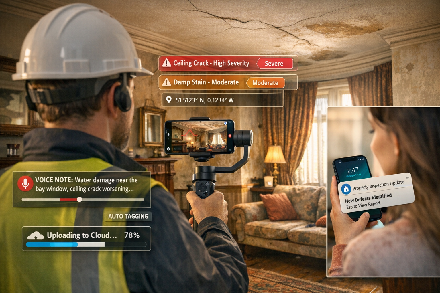
While 3D models provide comprehensive spatial context, annotated photography remains the workhorse of effective visual communication in building surveys. Modern digital reporting platforms enable surveyors to capture high-resolution images on-site, immediately annotate them with arrows, circles, and text callouts, and organize them within report structures—all from mobile devices.
This capability transforms the survey workflow. Rather than taking hundreds of photos, returning to the office, sorting through them, selecting relevant images, and manually inserting them into report templates, surveyors can now build reports progressively during site visits. This approach reduces administrative time while ensuring that visual documentation directly supports written findings.
Thermal imaging has become increasingly valuable in 2026, particularly for identifying hidden defects:
- Moisture intrusion detection behind finished surfaces
- Insulation deficiencies revealing energy efficiency issues
- Air leakage identification around windows and doors
- Electrical hotspots indicating potential safety hazards
- Structural thermal bridging affecting comfort and performance
When integrated into digital reports with clear annotations explaining what thermal patterns indicate, these images transform abstract technical concepts into visually compelling evidence that clients immediately understand. The combination of visible-light photography, thermal imaging, and explanatory annotations creates a comprehensive visual narrative that supports informed decision-making.
3D Visualization as the New Standard
Design conversations are increasingly taking place directly within 3D models rather than traditional 2D plans, enabling quicker iterations, faster workflows, and stronger alignment throughout design and construction phases.[1] This shift affects how surveyors present their findings and how clients engage with survey information.
Modern digital reporting platforms enable surveyors to embed interactive 3D models directly within reports or provide links to cloud-hosted models that clients can explore in their web browsers without specialized software. These models can include:
- Color-coded defect locations showing severity and type at a glance
- Embedded annotations with detailed descriptions, photographs, and repair recommendations
- Measurement tools allowing clients to verify dimensions and plan renovations
- Cross-section views revealing internal construction and structural relationships
- Progress comparison when conducting follow-up surveys or monitoring repairs
For clients considering property purchases, the ability to virtually explore a building while reviewing survey findings creates unprecedented clarity. They can see exactly where that roof leak is located, understand how the foundation settlement affects multiple areas, and visualize the spatial relationships between different defects—all without requiring technical expertise to interpret complex architectural drawings.
The value extends beyond initial surveys. When clients proceed with renovations, they can share these 3D models with architects and contractors, providing accurate baseline documentation that reduces measurement errors and supports efficient project planning. This extended utility reinforces the surveyor's value proposition and creates opportunities for ongoing client relationships.
Cloud-Based Platforms and Client Communication Excellence
Transforming Delivery: From Documents to Experiences
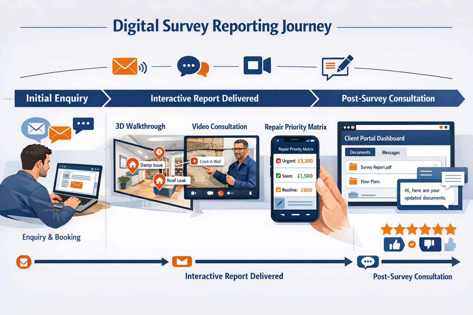
Cloud-based platforms now enable instant file sharing, 3D visualization in browser, real-time revision syncing, and integrated communication with engineers and architects—transforming surveying from static document delivery to interactive, collaborative workflows.[2] This transformation fundamentally changes how surveyors interact with clients throughout the survey process and beyond.
Traditional survey delivery involved emailing large PDF files, often too large for standard email systems, requiring file transfer services or physical media. Clients received these documents, reviewed them in isolation, and then contacted the surveyor with questions—creating a disjointed, inefficient communication pattern.
Modern cloud-based delivery creates a fundamentally different experience:
- Instant access via secure client portals accessible from any device
- Progressive delivery with preliminary findings available before final report completion
- Interactive commenting allowing clients to ask questions directly on specific findings
- Notification systems alerting clients to updates, responses, and new information
- Version control ensuring everyone works from the latest information
- Long-term accessibility with reports remaining available for years, not lost in email archives
This approach transforms the surveyor-client relationship from transactional to consultative. Rather than delivering a document and moving to the next project, surveyors maintain engagement, answer questions efficiently, and position themselves as trusted advisors throughout the property ownership journey.
Real-Time Collaboration and Stakeholder Coordination
Building Survey Digital Reporting: Visual Documentation and Client Communication in a Recovering Market extends beyond the direct client relationship to encompass all project stakeholders. In 2026, property transactions and renovation projects involve multiple parties—buyers, sellers, estate agents, solicitors, mortgage lenders, architects, and contractors—each requiring access to relevant survey information.
Cloud-based platforms facilitate this coordination through:
- Role-based access control providing appropriate information to each stakeholder
- Shared annotation capabilities enabling collaborative review and planning
- Integration with project management tools connecting survey findings to action items
- Automated report distribution ensuring all parties receive updates simultaneously
- Audit trails documenting who accessed what information and when
This collaborative approach proves particularly valuable for commercial building surveys, where multiple stakeholders require coordinated access to technical information. Rather than creating multiple report versions or managing complex email chains, surveyors can provide a single source of truth that all parties access according to their needs and permissions.
The efficiency gains are substantial. Questions that previously required phone tag or email exchanges can be resolved through platform messaging. Clarifications that once delayed transactions can be addressed immediately. Stakeholders who need specific information can access it directly without burdening the surveyor with repeated requests.
Mobile Accessibility and Client Empowerment
In 2026, mobile accessibility isn't optional—it's expected. Clients review survey reports on smartphones and tablets, often while physically at the property or discussing findings with family members. Digital reporting platforms optimized for mobile devices ensure that complex visual documentation remains accessible and useful regardless of screen size.
Mobile-optimized features include:
- 📱 Responsive layouts adapting content presentation to screen dimensions
- 🖼️ Touch-friendly navigation enabling intuitive exploration of 3D models and image galleries
- 🔊 Video and audio integration supporting multimedia explanations of complex issues
- 📍 Location-based organization allowing clients to navigate findings by property area
- 💬 Push notifications alerting clients to surveyor responses and report updates
This mobile accessibility empowers clients to engage with survey information on their own terms and timeline. They can review findings during property viewings, share specific sections with advisors, and make informed decisions without being tethered to desktop computers or printed documents.
The empowerment extends to decision-making. When clients can easily access comprehensive visual documentation, compare different properties they're considering, and review findings multiple times at their convenience, they make more confident decisions and experience less anxiety throughout the property transaction process. This improved experience directly translates to higher satisfaction scores and increased referrals.
Building Information Modeling Integration and Lifecycle Value
From Survey to BIM: Expanding Service Value
Land surveyors are increasingly collaborating with architects, engineers, and construction professionals to integrate geospatial data into BIM models, enhancing project planning, reducing conflicts, and improving construction efficiency.[2] This integration represents a significant opportunity for surveying firms to expand their value proposition beyond traditional one-time assessments.
Building Information Modeling (BIM) has become standard practice in commercial construction and is increasingly common in high-end residential projects. BIM workflows require accurate existing condition documentation as a foundation for design work. Surveyors who deliver data optimized for BIM integration position themselves as essential collaborative partners rather than measurement service vendors.
BIM-ready survey deliverables include:
- Point cloud data in formats compatible with major BIM platforms (Revit, ArchiCAD, etc.)
- Classified elements with building components identified and tagged appropriately
- Coordinate systems aligned with project requirements and local standards
- Level of detail appropriate for intended design and construction purposes
- Metadata supporting downstream workflows and information management
For clients planning renovations or developments, BIM-integrated survey data eliminates redundant measurement activities, reduces design errors caused by inaccurate existing condition assumptions, and accelerates project timelines. The value proposition is compelling: invest in comprehensive survey documentation upfront and realize efficiency gains throughout design and construction.
This approach also creates opportunities for ongoing client relationships. As projects progress, surveyors can provide verification surveys confirming that construction matches design intent, progress monitoring documenting completion milestones, and as-built documentation capturing final conditions—all integrated within the same BIM environment.
Common Data Environments: The Future of Project Delivery
Common Data Environments (CDEs) are accelerating in adoption across construction, representing both a delivery platform and collaboration tool that transforms how spatial information integrates with broader project data.[1] Rather than producing isolated deliverables, surveyors increasingly contribute to dynamic, shared environments where their work informs real-time decision-making.
CDEs function as centralized repositories for all project information—drawings, specifications, schedules, correspondence, and survey data—accessible to all authorized stakeholders throughout project lifecycles. When survey information resides within CDEs, it becomes part of the project's permanent record, available for reference during design, construction, operations, and future modifications.
Benefits of CDE integration for surveying firms:
- 🔗 Seamless information flow eliminating manual data transfers and format conversions
- 📊 Enhanced visibility showcasing surveyor contributions to project success
- 🤝 Collaborative workflows enabling real-time coordination with other disciplines
- 🔒 Information security through enterprise-grade platforms with robust access controls
- 📈 Performance metrics demonstrating efficiency and quality through platform analytics
For clients, CDE-based delivery provides unprecedented transparency and accessibility. They can see how survey findings inform design decisions, track how identified issues are addressed, and maintain comprehensive project documentation that supports future asset management activities.
This integration positions surveyors at the center of construction workflows rather than the periphery. When design teams reference survey data directly within their working environment, when contractors access site condition documentation during planning, and when facility managers rely on as-built survey information for maintenance—the surveyor's value becomes embedded throughout the asset lifecycle.
Lifecycle Asset Management: Recurring Revenue Opportunities
As much as 75% of an asset's total cost of ownership accrues during operations and maintenance phases.[1] This statistic reveals a significant opportunity: spatial data collected during planning and construction retains value for decades, enabling predictive maintenance that can reduce costs by as much as 40%, creating recurring revenue opportunities for surveying firms.
Traditional surveying business models focus on one-time engagements: conduct the survey, deliver the report, move to the next client. While this approach generates revenue, it leaves substantial value on the table. The comprehensive visual documentation and spatial data captured during initial surveys provides a foundation for ongoing asset management services that generate recurring revenue while deepening client relationships.
Lifecycle asset management services surveyors can offer:
| Service | Description | Client Value | Revenue Model |
|---|---|---|---|
| Condition Monitoring | Periodic surveys comparing current state to baseline | Early defect detection, maintenance planning | Annual or biennial retainers |
| Facility Documentation | Maintaining current as-built records as modifications occur | Accurate information for operations and future projects | Per-update fees or subscriptions |
| Compliance Verification | Regular assessments confirming regulatory compliance | Risk mitigation, audit support | Annual engagements |
| Energy Performance | Thermal imaging and analysis tracking efficiency over time | Cost reduction, sustainability goals | Quarterly or annual assessments |
| Renovation Planning | Existing condition surveys supporting modification projects | Accurate design foundation, reduced contingencies | Project-based fees |
These services transform the surveyor-client relationship from transactional to strategic partnership. Clients benefit from professional oversight that protects their investment and optimizes operational costs. Surveyors benefit from predictable recurring revenue that stabilizes cash flow and increases firm valuation.
The visual documentation created during initial surveys becomes increasingly valuable over time. Baseline 3D models enable precise change detection during subsequent assessments. Historical photographic records document condition evolution. Thermal imaging baselines reveal performance degradation. This accumulated data creates a comprehensive asset history that becomes more valuable with each additional data point.
Practical Implementation: Technology Selection and Workflow Integration
Choosing the Right Digital Reporting Platform
The marketplace offers numerous digital reporting platforms, each with different capabilities, pricing models, and learning curves. Selecting the right platform requires careful consideration of firm size, service offerings, client demographics, and growth objectives.
Key evaluation criteria:
- Ease of use: Intuitive interfaces that minimize training requirements and maximize adoption
- Mobile functionality: Robust field data capture capabilities supporting on-site report building
- Customization: Ability to create branded templates matching firm identity and service standards
- Integration: Compatibility with existing software (accounting, CRM, CAD, BIM platforms)
- Scalability: Pricing and features that accommodate growth without requiring platform changes
- Support: Responsive technical assistance and comprehensive training resources
- Client experience: Portal functionality, accessibility, and user experience for report recipients
Many platforms offer free trials or demonstration accounts, enabling hands-on evaluation before commitment. Involving surveyors who will actually use the platform in the evaluation process increases adoption success and identifies practical considerations that might not be apparent during sales presentations.
For firms just beginning digital transformation, starting with platforms that offer strong templates and guided workflows can accelerate implementation. As capabilities mature, migration to more sophisticated platforms with advanced customization becomes feasible. The key is beginning the journey rather than waiting for the "perfect" solution.
Workflow Integration and Team Training
Technology alone doesn't transform survey delivery—effective workflow integration and team adoption determine success. Even the most sophisticated digital reporting platform delivers minimal value if surveyors continue working in familiar patterns and only use new tools for final report assembly.
Successful implementation requires:
- Workflow mapping: Document current processes, identify inefficiencies, and design optimized workflows leveraging new capabilities
- Phased rollout: Begin with pilot projects, learn from experience, and gradually expand usage across all engagements
- Training investment: Provide comprehensive initial training plus ongoing skill development as platform capabilities expand
- Champion identification: Designate technology-enthusiastic team members to lead adoption and support colleagues
- Feedback loops: Regularly collect user input, address concerns, and refine workflows based on practical experience
- Client communication: Inform clients about enhanced capabilities and educate them on accessing and using digital deliverables
Resistance to change is natural, particularly among experienced surveyors comfortable with established methods. Emphasizing client benefits rather than technology features helps overcome resistance. When team members see clients' enthusiastic responses to interactive 3D models and annotated visual documentation, adoption accelerates organically.
Measuring and celebrating success reinforces adoption. Tracking metrics like report turnaround time, client satisfaction scores, referral rates, and administrative time savings demonstrates tangible benefits that justify the investment and effort required for transformation.
Data Management and Quality Control
Digital reporting generates substantially more data than traditional methods—high-resolution photographs, 3D models, thermal images, and supporting documentation accumulate quickly. Without proper data management protocols, this wealth of information becomes an organizational burden rather than an asset.
Essential data management practices:
- 📁 Consistent naming conventions enabling quick file identification and retrieval
- 🗄️ Structured storage hierarchies organizing data by client, property, and date
- ☁️ Cloud backup systems protecting against data loss while enabling remote access
- 🔒 Security protocols safeguarding sensitive client information and maintaining confidentiality
- ⏰ Retention policies balancing long-term reference value against storage costs
- 🔍 Metadata tagging supporting searchability and information discovery
Quality control becomes both easier and more critical with digital reporting. The ability to review comprehensive visual documentation remotely enables thorough desk-based quality checks before report finalization. However, the volume of data and ease of capture can lead to inclusion of irrelevant or poor-quality images if quality standards aren't maintained.
Establishing clear quality criteria—minimum image resolution, required annotations, thermal imaging protocols, 3D model completeness—ensures consistent deliverable quality regardless of which surveyor conducts the assessment. Regular quality audits reviewing completed reports against established standards identify training needs and maintain professional excellence.
Competitive Differentiation in the 2026 Market
Marketing Digital Capabilities Effectively
Investing in digital reporting technology delivers minimal competitive advantage if potential clients don't understand the superior value proposition. Effective marketing communicates capabilities in terms clients understand and value, focusing on benefits rather than technical specifications.
Effective marketing approaches:
- Sample reports: Provide anonymized examples showcasing interactive features and visual quality
- Video demonstrations: Create short videos walking through digital report features and client portal functionality
- Client testimonials: Feature satisfied clients describing how digital reporting improved their experience
-
- Before/after comparisons: Show traditional versus digital reporting approaches highlighting improvements
- Educational content: Publish blog posts and guides explaining how advanced reporting benefits property buyers
For firms seeking to understand how to choose qualified building surveyors in London, digital reporting capabilities increasingly factor into selection criteria. Demonstrating technological sophistication signals professionalism, investment in quality, and commitment to client service excellence.
Website optimization plays a crucial role. Rather than simply mentioning "digital reports," websites should feature interactive examples, embedded 3D models, and clear explanations of what clients receive. Visual demonstrations communicate value far more effectively than text descriptions, particularly for clients unfamiliar with surveying services.
Pricing Strategies for Enhanced Deliverables
Digital reporting requires investment—in technology, training, and time. While efficiency gains eventually offset these costs, firms must decide whether to charge premium prices for enhanced deliverables or use them as differentiators while maintaining competitive pricing.
Both approaches have merit:
Premium pricing positions digital reporting as a superior service tier, appealing to clients who prioritize quality and comprehensive documentation. This approach works well for Level 3 surveys where clients already expect comprehensive assessments and detailed reporting.
Competitive pricing uses digital reporting as a differentiator while maintaining market-rate fees, capturing market share from firms still using traditional methods. This approach accelerates adoption and builds client base, with profitability improving as efficiency gains reduce delivery costs.
Many firms adopt a hybrid approach: standard surveys include basic digital features (cloud delivery, annotated photography), while premium packages offer advanced capabilities (3D models, thermal imaging, BIM-ready deliverables). This tiered structure accommodates different client budgets while showcasing advanced capabilities to all clients.
Transparency about pricing helps clients understand value. Rather than simply stating fees, explaining what's included—unlimited cloud access, interactive 3D models, thermal imaging analysis, video consultation—justifies pricing and differentiates from competitors offering basic services at similar rates.
Client Education and Expectation Management
As digital reporting becomes more sophisticated, client education becomes increasingly important. Clients unfamiliar with 3D models, thermal imaging, or cloud platforms may not fully utilize available features without guidance. Proactive education maximizes client satisfaction and ensures they realize full value from enhanced deliverables.
Effective education strategies:
- Welcome guides: Provide simple instructions for accessing reports, navigating 3D models, and using commenting features
- Video tutorials: Create short videos demonstrating key features and answering common questions
- Live walkthroughs: Offer video calls to review reports together, highlighting important findings and demonstrating navigation
- FAQ sections: Address common questions about interpreting thermal images, understanding severity ratings, and using interactive features
- Follow-up check-ins: Contact clients after report delivery to ensure they accessed information successfully and address any questions
This educational approach transforms potential confusion into appreciation. Clients who initially feel overwhelmed by sophisticated deliverables become enthusiastic advocates once they understand how to access and use the information effectively.
Expectation management is equally important. Clearly communicating what digital reports include—and what they don't—prevents disappointment. For example, 3D models created from photogrammetry provide excellent visual documentation but may not have the precision of laser scanning. Thermal imaging identifies potential moisture issues but doesn't definitively diagnose causes. Setting appropriate expectations ensures clients understand both capabilities and limitations.
Future Trends and Emerging Technologies
Artificial Intelligence and Automated Defect Detection
AI and machine learning are enhancing spatial data processing, with cloud-based platforms enabling visual documentation that serves as a common language helping all stakeholders align efforts and reduce project misunderstandings.[1] These technologies are beginning to transform how surveyors identify, classify, and prioritize defects during property assessments.
Current and emerging AI applications:
- Automated crack detection in photographs, identifying and measuring structural defects
- Thermal anomaly flagging highlighting areas requiring detailed investigation
- Defect classification suggesting likely causes based on visual patterns and location
- Priority ranking assessing severity and recommending repair urgency
- Historical comparison detecting condition changes between successive surveys
- Report generation assistance drafting initial descriptions based on captured visual data
These capabilities don't replace professional judgment—they augment it. AI systems excel at processing large volumes of visual data quickly, identifying patterns humans might miss, and flagging areas requiring expert attention. Surveyors then apply their knowledge and experience to interpret findings, diagnose underlying causes, and recommend appropriate actions.
As these technologies mature, they'll enable more comprehensive assessments in less time. Surveyors will spend less time on routine documentation and more time on complex analysis and client consultation—activities that deliver higher value and justify professional fees.
IoT Integration and Continuous Monitoring
By 2026, IoT technologies are shifting from optional add-ons to essential policy and contractual requirements, with sensors, wearables, and connected equipment embedded throughout facilities to monitor energy consumption, structural health, and environmental conditions in real time.[3] This shift creates opportunities for surveyors to expand beyond periodic assessments into continuous monitoring services.
IoT applications in building surveys:
- Moisture sensors providing real-time alerts about water intrusion or rising damp
- Movement monitors tracking structural settlement or deflection over time
- Temperature and humidity sensors identifying conditions conducive to condensation or mold
- Air quality monitors assessing ventilation effectiveness and indoor environmental quality
- Energy meters tracking consumption patterns and identifying efficiency opportunities
These systems generate continuous data streams that complement periodic survey assessments. Rather than capturing a single snapshot of building conditions, surveyors can track trends, identify developing issues before they become serious, and provide proactive maintenance recommendations.
The business model implications are significant. IoT monitoring creates recurring revenue through sensor installation, data monitoring services, and periodic analysis and reporting. It also positions surveyors as ongoing partners in building performance optimization rather than one-time assessment providers.
Augmented Reality and Remote Survey Capabilities
COVID-19 accelerated remote surveying techniques adoption, with technology now enabling assessments and data collection with reduced on-site visits, increasing efficiency while addressing safety concerns.[2] Augmented reality (AR) takes this further, enabling remote experts to guide on-site personnel through complex assessments or allowing clients to visualize survey findings overlaid on actual properties.
AR applications include:
- Remote expert guidance: Senior surveyors directing junior staff through complex assessments via AR-enabled video calls
- Client visualization: Overlaying survey findings, repair recommendations, and renovation plans on properties using smartphone AR
- Defect highlighting: Marking specific concerns visible through device cameras during property viewings
- Measurement verification: Enabling clients to confirm dimensions and spatial relationships using AR measurement tools
- Historical comparison: Overlaying previous survey data on current conditions to visualize changes
These capabilities are becoming increasingly accessible as AR functionality becomes standard on smartphones and tablets. Surveyors don't need specialized equipment—clients can access AR features using devices they already own.
The efficiency implications are substantial. Remote guidance reduces travel time while maintaining quality. Client visualization improves understanding and reduces follow-up questions. Historical comparison streamlines repeat surveys and condition monitoring. As AR technology matures, it will become an expected feature of comprehensive digital reporting rather than a novelty.
Conclusion: Embracing Digital Transformation for Competitive Success
Building Survey Digital Reporting: Visual Documentation and Client Communication in a Recovering Market represents far more than a technological upgrade—it's a fundamental transformation of how surveying professionals serve clients, deliver value, and build sustainable businesses. As the property market recovers in 2026 and competition intensifies, firms that have embraced digital reporting tools find themselves with decisive advantages in client acquisition, satisfaction, and retention.
The evidence is compelling: clients expect interactive 3D models, comprehensive visual documentation, and instant cloud access to their survey information. They value surveyors who communicate clearly through annotated imagery and provide ongoing consultation through collaborative platforms. They increasingly select professionals based on technological sophistication and service experience rather than price alone.
For surveying firms, the path forward is clear:
Actionable Next Steps
- Evaluate current capabilities honestly, identifying gaps between what clients expect and what your firm currently delivers
- Research digital reporting platforms using free trials to assess usability, features, and fit with your service offerings
- Start small with pilot projects testing new technologies and workflows before full-scale implementation
- Invest in training ensuring team members have skills and confidence to leverage new capabilities effectively
- Communicate enhancements to existing and potential clients, showcasing superior deliverables and client experience
- Measure results tracking turnaround times, client satisfaction, referral rates, and efficiency gains
- Iterate and improve continuously refining workflows and expanding capabilities based on experience and feedback
The firms that thrive in the recovering market won't be those with the most sophisticated technology—they'll be those that use technology most effectively to serve clients, communicate clearly, and deliver exceptional value. Digital reporting tools are enablers, not solutions themselves. Success requires combining technology with professional expertise, client focus, and commitment to continuous improvement.
The opportunity is substantial. As reality capture democratizes, cloud platforms mature, and client expectations evolve, surveying firms of all sizes can compete effectively by delivering superior experiences. The barriers to entry have never been lower, the client value proposition never clearer, and the competitive advantages never more significant.
The question isn't whether to embrace digital transformation—it's how quickly your firm can implement these capabilities and begin realizing the benefits. In a recovering market where clients have choices and competition intensifies, those who move decisively will capture market share, build lasting client relationships, and position themselves for sustained success throughout 2026 and beyond.
Whether you're conducting comprehensive Level 3 building surveys, homebuyer surveys, or commercial property assessments, digital reporting transforms how you work, how clients perceive your value, and how your business grows. The technology is ready. The market is receptive. The time to act is now. 🚀
References
[1] Doubling Down On Digital – https://amerisurv.com/2026/02/01/doubling-down-on-digital/
[2] Future Land Surveying 2026 – https://haller-blanchard.com/future-land-surveying-2026/
[3] 2026 Construction Trends 25 Experts Share Insights – https://www.autodesk.com/blogs/construction/2026-construction-trends-25-experts-share-insights/