
The property surveying industry stands at a pivotal moment in 2026. What was once the exclusive domain of specialized firms with six-figure equipment budgets has become accessible to practitioners of all sizes. Reality capture technology—the process of digitally documenting physical spaces through 3D scanning, photogrammetry, and LiDAR—is no longer a luxury but an expectation. As reality capture goes mainstream, accessible tools transforming property surveys in 2026 are reshaping how professionals approach their work, from initial site documentation through long-term facility management.
The democratization of these technologies represents more than just new gadgets in the surveyor's toolkit. It fundamentally changes the precision, safety, and efficiency of property surveys while creating competitive advantages for firms that embrace the shift. According to industry experts, reality capture "will become even more democratized in 2026," with new user-friendly platforms enabling "more comprehensive data collection and in-field treatment for faster and improved decision making."[5]
Key Takeaways
- 📱 Mobile-first accessibility: Reality capture now extends beyond specialized hardware to include capture from smartphones and robust mobile mapping systems, dramatically reducing equipment costs and barriers to entry.[5]
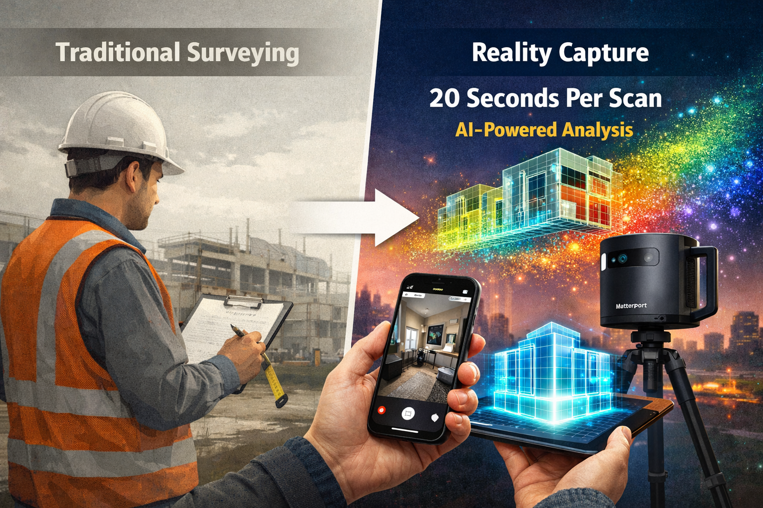
- ⚡ Speed revolution: Modern cameras like the Matterport Pro3 capture complete 3D data up to 100 meters away in less than 20 seconds per sweep, with automatic measurement and floor plan generation.[1]
- 🤖 AI-powered intelligence: Reality capture data is enhanced by artificial intelligence, machine learning, and cloud-based platforms, transforming spatial data into a common visual language across stakeholder teams.[5]
- 🏗️ Continuous verification: Teams have shifted from scheduled survey checkpoints to ongoing verification with time-stamped models that provide visual records of work progress and support quality documentation.[1]
- 💼 Competitive imperative: Clients increasingly expect rich digital deliverables rather than traditional survey products alone, making reality capture integration essential for maintaining market competitiveness.[5]
Understanding Reality Capture Technology in Modern Property Surveys
What Is Reality Capture?
Reality capture refers to the process of creating accurate digital representations of physical environments using various technologies. These digital twins capture the precise geometry, spatial relationships, and visual characteristics of buildings, land parcels, and infrastructure. The technology suite includes:
- LiDAR (Light Detection and Ranging): Uses laser pulses to measure distances and create detailed 3D point clouds
- Photogrammetry: Processes overlapping photographs to generate 3D models
- 3D Laser Scanning: Captures millions of measurement points to document complex structures
- GNSS RTK Systems: Provides centimeter-level positioning accuracy for georeferenced data
- UAV (Drone) Photogrammetry: Captures aerial perspectives and large-area documentation
- Mobile Mapping Systems: Combines multiple sensors for efficient large-scale capture[3]
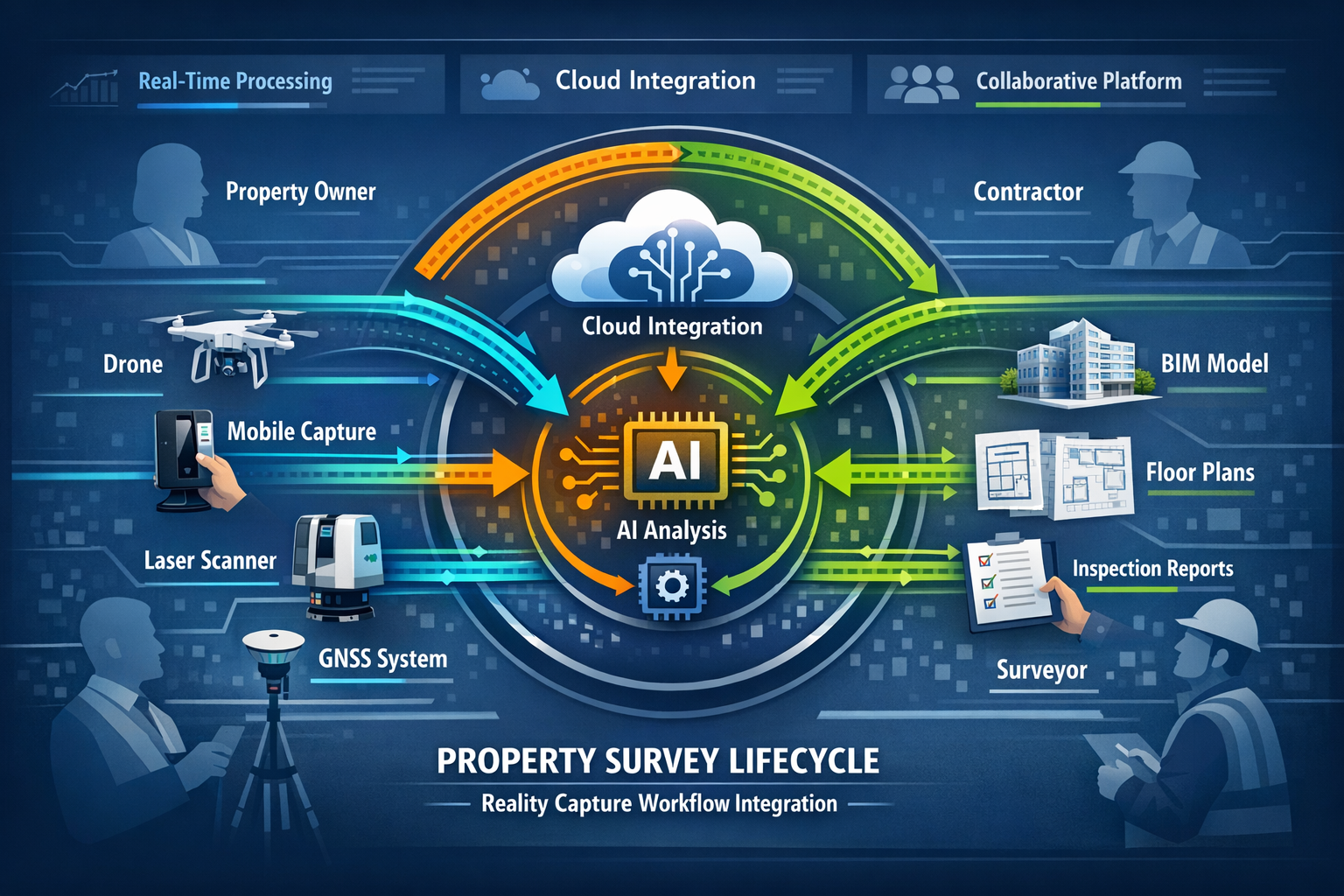
The convergence of these technologies with real-time data processing using AI has created a comprehensive toolkit that adapts to virtually any surveying scenario.[3]
The Shift from Niche to Mainstream
The transformation of reality capture from specialized service to standard practice reflects several converging trends. Hardware costs have plummeted while capabilities have expanded. Equipment that once required dedicated operators and extensive training now features intuitive interfaces that surveying professionals can master in days rather than months.
"Reality capture will become even more democratized in 2026, with new user-friendly platforms enabling more comprehensive data collection and in-field treatment for faster and improved decision making." — Arnaud Lezennec, Senior Applications Engineer, Trimble[5]
This accessibility extends beyond traditional surveying firms. Property managers, construction contractors, and even individual property owners can now leverage reality capture for their specific needs. When conducting commercial building surveys, professionals increasingly integrate reality capture as a standard component rather than an optional add-on.
Integration with Building Information Modeling (BIM)
The true power of reality capture emerges through its seamless integration with Building Information Modeling (BIM) platforms and project management tools.[1][4] Survey data no longer exists in isolation but becomes part of a connected ecosystem where:
- As-built conditions automatically compare against design intent
- RFIs (Requests for Information) link directly to visual documentation
- Clash detection identifies conflicts before construction begins
- Progress tracking provides stakeholders with real-time project visibility
- Facility management systems maintain comprehensive building records
This integration transforms reality capture from a documentation tool into a decision-making platform that supports collaboration across the entire project lifecycle.
How Reality Capture Goes Mainstream: Accessible Tools Transforming Property Surveys in 2026
User-Friendly Platforms Lowering Barriers to Entry
The most significant driver of mainstream adoption has been the development of platforms that prioritize user experience without sacrificing capability. Modern reality capture solutions feature:
Automated Processing Workflows 🤖
Gone are the days of manual point cloud registration and extensive post-processing. Today's platforms automatically:
- Align multiple scans into cohesive models
- Extract measurements and generate floor plans
- Identify and classify building elements
- Produce deliverables in industry-standard formats
Cloud-Based Collaboration ☁️
Cloud platforms enable teams to:
- Access survey data from any device with internet connectivity
- Share models with clients and stakeholders without specialized software
- Collaborate in real-time with annotations and markups
- Maintain version control and audit trails
Simplified Hardware Operation 📷
The Matterport Pro3 camera exemplifies this trend, capturing complete 3D data up to 100 meters away in less than 20 seconds per sweep while automatically generating measurements and floor plans.[1] The device requires minimal training, allowing surveyors to focus on professional judgment rather than technical operation.
Mobile Phone Capture: The Ultimate Accessibility
Perhaps nothing demonstrates the democratization of reality capture more than the expansion to mobile phone-based solutions. Reality capture now includes "capture from mobile phones and robust mobile mapping systems,"[5] enabling professionals to:
- Conduct preliminary surveys using devices already in their pockets
- Document conditions immediately without returning to the office for specialized equipment
- Reduce equipment costs for small firms and individual practitioners
- Increase capture frequency by eliminating logistical barriers
While mobile phone capture may not match the precision of dedicated scanners for all applications, it provides sufficient accuracy for many common surveying tasks, particularly when conducting initial homebuyer surveys or preliminary site assessments.
Speed Improvements Transforming Project Timelines
The velocity of modern reality capture represents a quantum leap from traditional surveying methods. Consider these timeline comparisons:
| Survey Method | Time Required | Data Density | Revisit Capability |
|---|---|---|---|
| Traditional Tape Measure | 4-8 hours | Low (selective points) | Requires site return |
| Total Station | 2-4 hours | Medium (targeted points) | Requires site return |
| 3D Laser Scanner (2020) | 1-2 hours | High (millions of points) | Digital revisit possible |
| Modern Reality Capture (2026) | 20-40 minutes | Very High (complete environment) | Unlimited digital revisits |
These speed improvements cascade through entire project timelines. What once required multiple site visits, extensive measurement sessions, and weeks of processing can now be completed in a single brief visit with deliverables available within hours.
For professionals conducting Level 3 building surveys, this efficiency allows more thorough documentation without extending project timelines or increasing costs.
Precision, Safety, and Risk Reduction Benefits
Enhanced Measurement Accuracy
Reality capture systems achieve measurement precision that exceeds traditional methods across multiple dimensions:
Completeness of Documentation 📊
Traditional surveys capture selective measurements based on the surveyor's judgment about what will prove important. Reality capture documents everything, creating a complete digital record that can be measured and analyzed indefinitely. This comprehensive approach eliminates the common scenario where teams discover they need a measurement that wasn't captured during the original site visit.
Consistency Across Teams 👥
Human measurement introduces variability based on individual technique, experience, and environmental conditions. Reality capture standardizes data collection, ensuring consistent results regardless of which team member operates the equipment. This consistency proves particularly valuable for firms conducting structural surveys where precision directly impacts safety assessments.
Verification and Quality Control ✅
The digital nature of reality capture data enables systematic quality control. Teams can:
- Compare multiple scans to identify discrepancies
- Overlay design models against as-built conditions
- Track dimensional changes over time
- Validate measurements through independent analysis
Safety Improvements Through Remote Assessment
Reality capture fundamentally changes the safety equation for property surveys by enabling teams to "document conditions in short on-site visits, with much review work conducted remotely."[1] This approach reduces exposure to hazardous conditions including:
- Unstable structures requiring minimal inspection time
- Contaminated environments limiting human exposure
- Height-related risks through drone-based capture
- Traffic hazards on active construction sites
- Weather-related dangers by condensing on-site time
The ability to conduct thorough analysis from the safety of an office environment represents a significant advancement in occupational health and safety for surveying professionals.
Continuous Verification Replacing Scheduled Checkpoints
The traditional approach to construction verification relied on scheduled survey checkpoints at predetermined project milestones. This method created several problems:
- Delayed issue identification until the next scheduled inspection
- Costly rework when problems were discovered late
- Limited documentation of intermediate conditions
- Disputes about work quality and timeline
Reality capture enables a shift toward continuous verification with time-stamped models that provide visual records of work progress and support quality documentation in context.[1] Project teams can now:
- Document conditions at any frequency needed
- Create permanent records of work before it's concealed
- Resolve disputes with objective visual evidence
- Track progress against schedule in real-time
This continuous approach to verification reduces risk throughout the construction process and creates comprehensive documentation for long-term facility management.
Case Studies: Adoption Barriers and Success Stories
Small Firm Success: Overcoming Initial Skepticism
Challenge: A regional surveying practice with five employees hesitated to invest in reality capture technology, concerned about equipment costs, training requirements, and whether clients would value the enhanced deliverables.
Solution: The firm started with a mid-range 3D scanner and cloud-based processing platform, investing approximately £15,000—far less than the six-figure systems of previous generations. They integrated reality capture selectively, beginning with commercial property surveys where the technology provided clear differentiation.
Results:
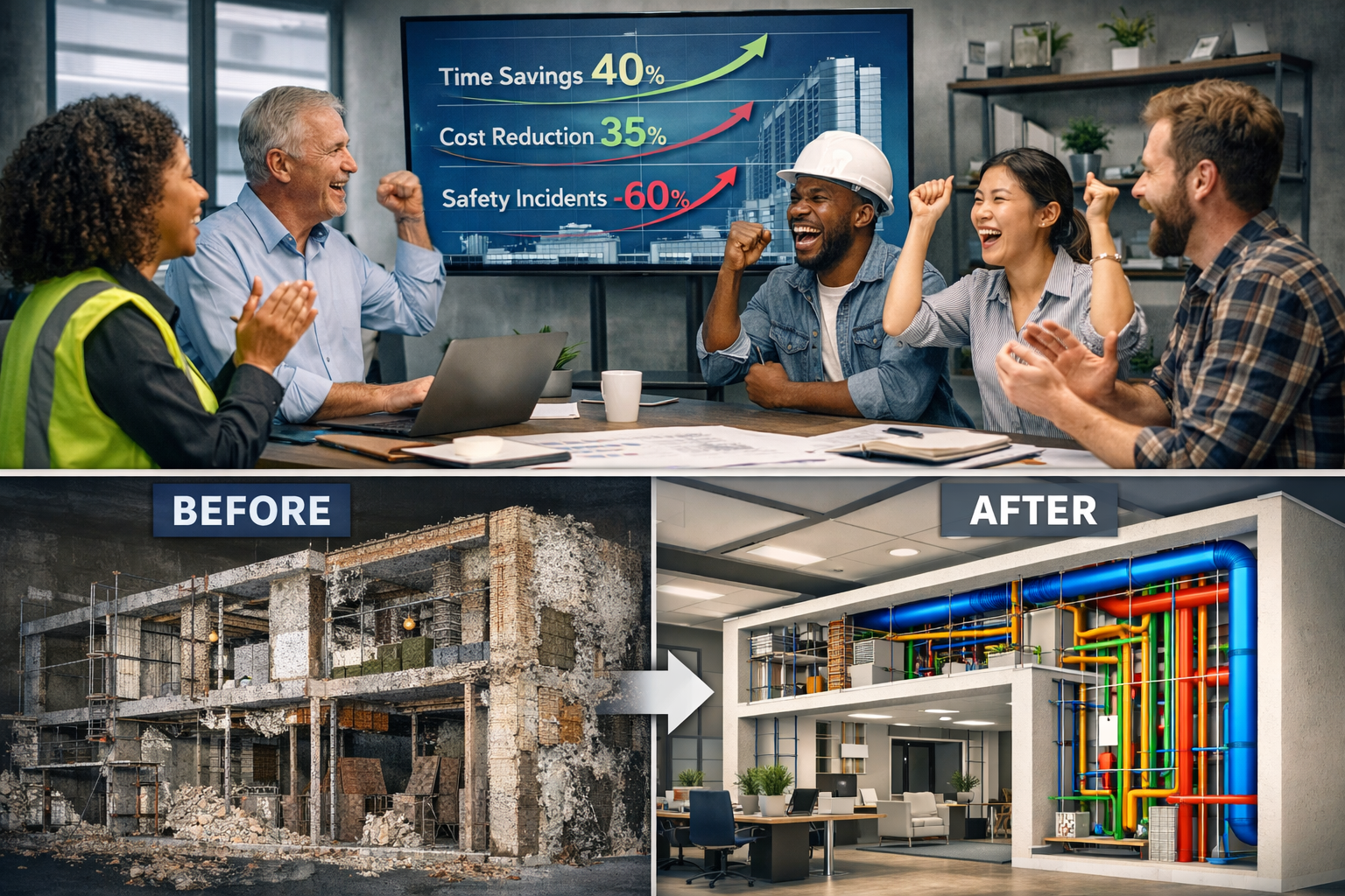
- ✅ 40% reduction in site visit time while capturing more comprehensive data
- ✅ Client retention increased 25% as stakeholders valued digital deliverables
- ✅ New revenue streams from facility management clients requesting periodic updates
- ✅ Competitive advantage in tender processes against larger firms
Key Success Factor: The firm focused on integration rather than replacement, using reality capture to enhance their existing expertise rather than attempting to transform their entire practice overnight.
Enterprise Adoption: Scaling Across Multiple Offices
Challenge: A national surveying firm with 12 regional offices struggled to maintain consistent quality and deliverable standards across geographically dispersed teams with varying skill levels.
Solution: The firm implemented a standardized reality capture platform across all locations, with centralized processing and quality control. They developed internal protocols for when to deploy different capture technologies based on project requirements and integrated the data with their existing building survey workflows.
Results:
- ✅ Standardized deliverables regardless of which office conducted the survey
- ✅ Knowledge transfer as experienced surveyors could review and mentor based on captured data
- ✅ Capacity flexibility allowing any office to support others during peak periods
- ✅ 35% reduction in callbacks for missing measurements
Key Success Factor: Centralized training and quality control processes ensured consistent implementation despite the distributed nature of the organization.
Barrier: Technology Overwhelm and Feature Paralysis
Common Challenge: Many firms report feeling overwhelmed by the rapid pace of technology development and the extensive feature sets of modern reality capture platforms. This "feature paralysis" can delay adoption as teams wait for the "perfect" solution or attempt to master every capability before beginning practical use.
Successful Approach: Leading adopters recommend a phased implementation strategy:
- Start with core functionality: Master basic capture and measurement before exploring advanced features
- Identify specific use cases: Focus on problems reality capture solves rather than capabilities it offers
- Measure concrete outcomes: Track time savings, accuracy improvements, and client satisfaction
- Expand gradually: Add capabilities as team competency and client demand grow
- Leverage vendor support: Utilize training resources and technical support during the learning curve
This pragmatic approach prevents technology from becoming an obstacle rather than an enabler.
Success Factor: Client Education and Expectation Management
Firms that successfully integrate reality capture invest in client education to ensure stakeholders understand and value the enhanced deliverables. Effective strategies include:
- Visual demonstrations showing the difference between traditional and digital survey products
- Interactive model sharing allowing clients to explore their properties virtually
- Clear value propositions connecting technology to specific client benefits (time, cost, risk reduction)
- Graduated service tiers offering traditional surveys alongside enhanced digital options
As clients increasingly expect "rich digital deliverables" rather than traditional survey products alone,[5] firms that proactively educate their market create competitive advantages while supporting broader industry transformation.
Reality Capture Across Different Property Survey Types
Residential Property Surveys
For Level 3 home surveys and homebuyer inspections, reality capture provides:
Comprehensive Documentation 🏠
- Complete exterior and interior measurements
- Detailed records of existing conditions
- Visual documentation of defects and concerns
- Baseline data for future renovations
Enhanced Client Communication 💬
- Virtual walkthroughs for remote buyers
- Clear visual explanation of findings
- Permanent reference for maintenance planning
- Shareable models for contractor estimates
The technology proves particularly valuable for period properties and buildings with complex architectural features where traditional measurement proves challenging and time-consuming.
Commercial Building Surveys
Commercial building surveys benefit from reality capture through:
Tenant Improvement Planning 🏢
- Accurate as-built conditions for space planning
- Coordination with mechanical, electrical, and plumbing systems
- Lease documentation and dilapidations surveys
- Facility management integration
Asset Management 📈
- Portfolio-wide documentation standards
- Condition assessment tracking over time
- Capital planning and budgeting support
- Due diligence for acquisitions and dispositions
The ability to capture large commercial spaces quickly while maintaining accuracy makes reality capture particularly cost-effective for this sector.
Specialized Applications
Party Wall Surveys 🧱
When conducting party wall surveys, reality capture provides:
- Objective baseline documentation before construction begins
- Detailed records of existing conditions for dispute resolution
- Visual evidence accessible to all parties
- Precise measurements of structural elements
Heritage and Conservation 🏛️
Historic buildings benefit from non-invasive documentation that:
- Captures intricate architectural details
- Creates permanent digital archives
- Supports restoration planning
- Monitors structural stability over time
Infrastructure and Civil Engineering 🌉
Large-scale projects utilize reality capture for:
- Corridor mapping and right-of-way documentation
- Bridge and tunnel inspection
- Utility mapping and coordination
- Progress monitoring on linear projects
Integration with AI and Machine Learning
Automated Feature Recognition
The integration of reality capture with artificial intelligence and machine learning represents the next frontier in survey automation.[5] Modern platforms can automatically:
- Identify building elements: Walls, doors, windows, structural components
- Classify materials: Distinguish between concrete, wood, metal, glass
- Detect defects: Identify cracks, moisture damage, structural concerns
- Extract measurements: Generate floor plans, elevations, and sections
- Compare conditions: Highlight changes between survey dates
This automated analysis dramatically reduces the time required to produce deliverables while improving consistency and completeness.
Predictive Analytics for Maintenance
Beyond documentation, AI-enhanced reality capture enables predictive maintenance by:
- Analyzing condition trends over multiple survey periods
- Identifying patterns that precede failure
- Prioritizing maintenance interventions by risk and impact
- Optimizing capital planning and budgeting
For facility managers and building owners, this predictive capability transforms survey data from historical documentation into forward-looking strategic intelligence.
Cloud-Based Processing and Accessibility
Cloud-based platforms have eliminated the need for expensive local computing infrastructure while enabling new collaboration models.[5] Benefits include:
Scalable Processing Power ⚡
- Handle large datasets without local hardware investment
- Process multiple projects simultaneously
- Access latest algorithms without software updates
Universal Accessibility 🌐
- Review survey data from any device
- Share with unlimited stakeholders
- Integrate with other cloud-based project tools
- Maintain single source of truth across teams
Data Security and Backup 🔒
- Enterprise-grade security protocols
- Automatic backup and version control
- Compliance with data protection regulations
- Disaster recovery capabilities
Multi-Layered Documentation and Hidden Systems Visualization
Synchronizing Rough and Finished Conditions
One of the most powerful applications of reality capture involves multi-layered documentation that reveals systems concealed within finished construction. The Matterport and SIMLAB STAGES integration enables synchronization of rough-construction models with finished conditions, revealing hidden systems such as pipes, wiring, and services inside completed walls and ceilings.[1]
This capability provides tremendous value for:
Facility Management 🔧
- Locating concealed utilities for maintenance
- Planning renovations without destructive investigation
- Troubleshooting system problems efficiently
- Training new facility staff on building systems
Future Renovations 🏗️
- Understanding existing conditions before design
- Avoiding conflicts with concealed systems
- Reducing unexpected conditions and change orders
- Improving cost estimating accuracy
Emergency Response 🚨
- Quickly locating shutoff valves and electrical panels
- Understanding building layout for fire and safety planning
- Coordinating with emergency services
- Reducing response times during critical events
Creating Comprehensive Lifecycle Assets
Reality capture data increasingly functions as a long-term asset that supports the entire building lifecycle rather than serving a single point-in-time purpose.[1] This lifecycle approach includes:
Design and Planning Phase 📐
- Existing conditions documentation
- Site analysis and constraints
- Design development and coordination
- Stakeholder communication and approvals
Construction Phase 🏗️
- Progress documentation and verification
- Quality control and compliance
- Change order documentation
- As-built record creation
Operations and Maintenance Phase 🔧
- Facility management integration
- Maintenance planning and execution
- Space planning and tenant improvements
- Energy management and optimization
Renovation and Disposal Phase ♻️
- Renovation planning and design
- Demolition planning and waste management
- Historic preservation and documentation
- End-of-life decision support
This comprehensive lifecycle perspective maximizes the return on investment in reality capture while supporting sustainable building practices.
Practical Implementation Guidance for Surveying Firms
Selecting Appropriate Technology for Your Practice
The diversity of reality capture technologies requires careful matching to specific practice needs. Consider these factors when evaluating options:
Project Types and Scale 📏
- Small residential: Mobile phone or entry-level 3D camera
- Large commercial: Professional-grade laser scanner or mobile mapping
- Infrastructure: Drone photogrammetry and GNSS RTK systems
- Mixed practice: Modular system with multiple capture methods
Budget Considerations 💰
- Entry-level systems: £5,000-£15,000
- Mid-range professional: £15,000-£40,000
- Enterprise solutions: £40,000-£100,000+
- Subscription vs. purchase models
Technical Capability 🎓
- In-house processing vs. cloud-based automation
- Training requirements and learning curve
- Technical support availability
- Integration with existing workflows
Client Expectations 🤝
- Deliverable format requirements
- Accuracy and precision standards
- Turnaround time expectations
- Competitive market positioning
Training and Competency Development
Successful reality capture implementation requires investment in team competency development:
Technical Training 📚
- Equipment operation and best practices
- Data processing and quality control
- Software proficiency for deliverable production
- Troubleshooting and problem-solving
Professional Judgment 🎯
- When to deploy different technologies
- Balancing speed, accuracy, and cost
- Quality assurance and validation
- Client communication and expectation management
Continuous Learning 🔄
- Industry conferences and workshops
- Vendor training and certification programs
- Peer learning and knowledge sharing
- Staying current with technology evolution
Many successful firms designate reality capture champions who develop deep expertise and support broader team adoption.
Quality Assurance and Professional Standards
As reality capture becomes standard practice, professional standards and quality assurance protocols must evolve accordingly. When conducting RICS building surveys, practitioners should:
Maintain Professional Standards ⚖️
- Follow RICS guidance on technology use
- Document methodology and equipment specifications
- Validate digital measurements against traditional methods during transition
- Maintain professional indemnity insurance covering technology use
Implement Quality Control ✓
- Systematic review of captured data completeness
- Verification measurements for critical dimensions
- Peer review of deliverables
- Client feedback and satisfaction tracking
Document Limitations 📋
- Clearly communicate technology capabilities and constraints
- Identify areas where traditional methods supplement digital capture
- Explain accuracy specifications and confidence levels
- Manage client expectations appropriately
The Competitive Landscape and Market Expectations
Client Demand for Digital Deliverables
The transformation of client expectations represents both an opportunity and a challenge for surveying practices. Clients increasingly expect rich digital deliverables rather than traditional survey products alone,[5] including:
Interactive 3D Models 🖥️
- Virtual property tours and walkthroughs
- Measurement tools for client self-service
- Annotation and collaboration capabilities
- Integration with client systems and workflows
Comprehensive Documentation Packages 📦
- Traditional reports enhanced with visual evidence
- Linked photographs and measurements
- Video walkthroughs with narration
- Digital archives for long-term reference
Data Integration and Interoperability 🔗
- BIM-compatible formats
- CAD drawings and models
- GIS integration for portfolio management
- API access for custom applications
Firms that cannot deliver these enhanced products increasingly find themselves at a competitive disadvantage, particularly when competing for commercial and institutional work.
Differentiation Strategies for Surveying Practices
Reality capture enables multiple differentiation strategies in competitive markets:
Service Enhancement ⭐
- Faster turnaround times
- More comprehensive documentation
- Higher accuracy and precision
- Enhanced client communication
New Service Offerings 🆕
- Facility management support
- Periodic condition monitoring
- Construction progress documentation
- Virtual staging and marketing support
Market Expansion 🌍
- Geographic expansion through remote review capabilities
- New client segments attracted by digital deliverables
- Cross-selling to existing clients
- Partnership opportunities with technology platforms
Operational Efficiency 📊
- Reduced site visit requirements
- Lower travel costs and time
- Improved team utilization
- Scalability without proportional staff growth
Understanding what surveyors look for in property surveys helps firms position reality capture as an enhancement to professional expertise rather than a replacement for it.
Pricing Strategies for Reality Capture Services
Integrating reality capture into service offerings requires thoughtful pricing strategy:
Value-Based Pricing 💎
- Price based on client outcomes rather than time invested
- Emphasize risk reduction and decision-making value
- Differentiate premium digital deliverables
- Bundle services for comprehensive solutions
Tiered Service Models 📊
- Basic: Traditional survey with limited digital enhancement
- Standard: Full reality capture with standard deliverables
- Premium: Enhanced processing, analysis, and ongoing support
- Custom: Tailored solutions for unique requirements
Efficiency Sharing 🤝
- Pass some cost savings to clients while maintaining margins
- Demonstrate ROI through faster timelines
- Reduce client costs for follow-up measurements
- Create long-term value through reusable data
The key is communicating the value proposition clearly so clients understand they're receiving enhanced outcomes, not simply paying for new technology.
Future Trends and Emerging Technologies
Continued Democratization and Accessibility
The trend toward accessibility shows no signs of slowing. Industry experts predict reality capture "will become even more democratized in 2026,"[5] with several emerging developments:
Smartphone Capability Advancement 📱
- LiDAR sensors becoming standard on consumer devices
- Improved photogrammetry algorithms for phone cameras
- Augmented reality integration for real-time visualization
- Direct integration with surveying software platforms
Artificial Intelligence Expansion 🤖
- Automated defect detection and classification
- Intelligent data capture optimization
- Natural language report generation
- Predictive analytics and trend identification
Sensor Fusion and Integration 🔬
- Combining multiple capture technologies automatically
- Thermal imaging integration for building performance
- Moisture detection and material analysis
- Environmental monitoring and air quality assessment
Autonomous Capture Systems
The next frontier involves autonomous and semi-autonomous capture systems that further reduce the time and expertise required:
Robotic Scanning Platforms 🤖
- Autonomous navigation through buildings
- Systematic coverage without operator intervention
- Continuous monitoring and change detection
- Integration with building management systems
Drone Automation 🚁
- Pre-programmed flight paths for consistent coverage
- Automatic obstacle avoidance and safety protocols
- Simultaneous capture from multiple drones
- Real-time processing and preliminary analysis
These autonomous systems promise to further reduce costs and increase accessibility, though professional expertise remains essential for interpretation and application of the data.
Integration with Digital Twin Ecosystems
Reality capture increasingly serves as the foundation for digital twin implementations that create living digital replicas of physical assets. These digital twins:
- Update continuously with new sensor data
- Simulate performance under different conditions
- Optimize operations and maintenance strategies
- Support strategic planning and investment decisions
For surveying professionals, this evolution positions reality capture as an ongoing service rather than a one-time deliverable, creating recurring revenue opportunities and deeper client relationships.
Addressing Common Concerns and Misconceptions
"Reality Capture Will Replace Surveyors"
Perhaps the most persistent concern involves technology displacement of professional expertise. The reality is quite different:
Technology Enhances Rather Than Replaces 🎯
Reality capture handles data collection and measurement, freeing surveyors to focus on:
- Professional judgment and interpretation
- Risk assessment and recommendations
- Client consultation and communication
- Complex problem-solving and analysis
Professional Expertise Becomes More Valuable 💼
As data becomes abundant, the ability to interpret, contextualize, and apply it becomes increasingly valuable. Surveyors who understand what chartered surveyors do recognize that technology elevates rather than diminishes their professional role.
"The Technology Is Too Expensive"
While high-end systems remain costly, the accessibility revolution has created options for every budget:
Entry Points for Every Practice 💰
- Smartphone apps: £0-£500 annually
- Consumer 3D cameras: £5,000-£10,000
- Professional systems: £15,000-£40,000
- Enterprise solutions: £40,000+
Return on Investment 📈
- Reduced site visit time and travel costs
- Increased project capacity without additional staff
- Premium pricing for enhanced deliverables
- Competitive advantage in tender processes
Most firms report ROI within 12-18 months of implementation when they integrate the technology systematically into their practice.
"Clients Don't Value Digital Deliverables"
This concern typically reflects insufficient client education rather than actual market preference:
Client Education Strategies 📚
- Demonstrate capabilities through sample projects
- Offer pilot programs at reduced rates
- Provide interactive demonstrations
- Share case studies and testimonials
Market Segmentation 🎯
- Some clients prioritize cost over enhanced deliverables
- Others value innovation and comprehensive documentation
- Commercial and institutional clients increasingly expect digital products
- Residential clients appreciate visual communication tools
The key is identifying client segments that value enhanced deliverables and communicating the benefits effectively.
Conclusion: Embracing the Mainstream Reality Capture Revolution
Reality capture goes mainstream in 2026 not as a distant possibility but as an observable transformation reshaping the property surveying profession. Accessible tools are transforming property surveys by democratizing capabilities once reserved for specialists, enabling firms of all sizes to deliver enhanced precision, improved safety, and accelerated timelines.
The evidence is compelling: modern systems capture complete 3D data in seconds, AI-enhanced platforms automate complex processing tasks, and cloud-based collaboration enables seamless stakeholder engagement. From Level 3 building surveys to commercial property assessments, reality capture enhances every aspect of professional practice.
Yet technology alone does not guarantee success. The firms thriving in this new landscape share common characteristics:
✅ Strategic implementation focused on solving specific problems rather than chasing capabilities
✅ Investment in training to develop team competency and confidence
✅ Client education to communicate value and manage expectations
✅ Quality assurance maintaining professional standards while adopting new methods
✅ Continuous learning staying current as technology evolves
Actionable Next Steps for Surveying Professionals
For Firms Just Beginning 🚀
- Identify specific use cases where reality capture solves current challenges
- Start with accessible technology such as mobile phone capture or entry-level 3D cameras
- Pilot on internal projects to develop competency before client deployment
- Measure concrete outcomes tracking time, accuracy, and client satisfaction
- Expand gradually adding capabilities as expertise and demand grow
For Firms Currently Implementing 📊
- Standardize workflows to ensure consistent quality across projects and team members
- Develop service tiers offering clients clear choices between traditional and enhanced deliverables
- Invest in advanced training to leverage AI, automation, and integration capabilities
- Build case studies documenting successes and lessons learned
- Explore new markets where enhanced capabilities create competitive advantages
For Advanced Practitioners 🎯
- Integrate with digital twin and lifecycle management strategies
- Develop specialized expertise in emerging applications and technologies
- Partner with technology providers to influence product development
- Share knowledge through industry associations and professional development
- Lead industry evolution by establishing best practices and standards
The Competitive Imperative
The question facing surveying professionals in 2026 is no longer whether to adopt reality capture but how quickly and effectively to integrate it into core practice. Client expectations continue to evolve, with digital deliverables becoming standard requirements rather than premium options. Firms that delay adoption risk finding themselves unable to compete for the most attractive projects and clients.
Yet this transformation also creates tremendous opportunity. The democratization of reality capture levels the playing field, allowing small and medium-sized firms to compete on capability rather than equipment budgets. Professional expertise, client relationships, and market knowledge remain the true differentiators—enhanced and amplified by accessible technology.
The future of property surveying combines human judgment with digital precision, professional experience with technological capability, and traditional expertise with innovative tools. Reality capture goes mainstream not by replacing surveyors but by empowering them to deliver unprecedented value to clients while building more efficient, profitable, and sustainable practices.
The revolution is here. The tools are accessible. The opportunity is clear. The only question remaining is how quickly your practice will embrace the transformation.
References
[1] 10 Ways 3d Scanner Technology Leads Efficiencies Surveying – https://matterport.com/blog/10-ways-3d-scanner-technology-leads-efficiencies-surveying
[2] Reality Capture – https://www.aecplustech.com/tools/category/reality-capture
[3] The Future Of Land Surveying Technology And Upcoming Trends In 2026 – https://metricop.com/blogs/land-surveying/the-future-of-land-surveying-technology-and-upcoming-trends-in-2026
[4] Construction Reality Capture The Foundation For Building Smarter – https://www.dronedeploy.com/blog/construction-reality-capture-the-foundation-for-building-smarter
[5] Doubling Down On Digital – https://amerisurv.com/2026/02/01/doubling-down-on-digital/
[6] Geo Week 2026 Highlights Reality Capture S Strategic Role – https://www.gim-international.com/content/news/geo-week-2026-highlights-reality-capture-s-strategic-role
[7] Reality Capture Network At Geo Week 2026 A Focus On Integration Precision And Enduring Data Value – https://www.geoweeknews.com/news/reality-capture-network-at-geo-week-2026-a-focus-on-integration-precision-and-enduring-data-value
[8] Reality Capture – https://geospatial.trimble.com/en/industries/surveying-and-mapping/reality-capture