
Boundary disputes cost English and Welsh homeowners an estimated tens of thousands of pounds each in legal fees, yet many begin with a single ambiguous phrase in a survey report: "on the border." Understanding what does "on the border" mean in property surveys, interpreting legal boundaries, valuation zones and planning lines in the UK is not merely an academic exercise. For buyers, sellers, developers and lenders, it is a question with direct financial and legal consequences.
This article unpacks every dimension of that phrase: what surveyors actually mean when they use it, how it relates to the legal concept of a boundary in English and Welsh law, and what practical steps property owners should take when a report flags something as sitting on, or very close to, a boundary line.
Key Takeaways
- "On the border" is informal surveying language, not a recognised legal term; the authoritative concepts are "general boundary" and "legal boundary" as defined by HM Land Registry [8]
- HM Land Registry title plans show only a general boundary based on Ordnance Survey data and are not a guaranteed measure of the exact legal boundary position [8]
- The phrase can refer to proximity to a physical property boundary, a local authority boundary, a flood risk zone edge, a conservation area line, or a valuation "borderline", each carrying different implications
- The RICS professional standard on boundaries (4th edition, October 2022) is the current benchmark for identifying, demarcating and resolving boundary issues in the UK [2]
- Early instruction of a chartered surveyor and, where necessary, use of the RICS boundary disputes mediation service can prevent disproportionate legal costs [10]
The Multiple Meanings of "On the Border" in UK Property Surveys
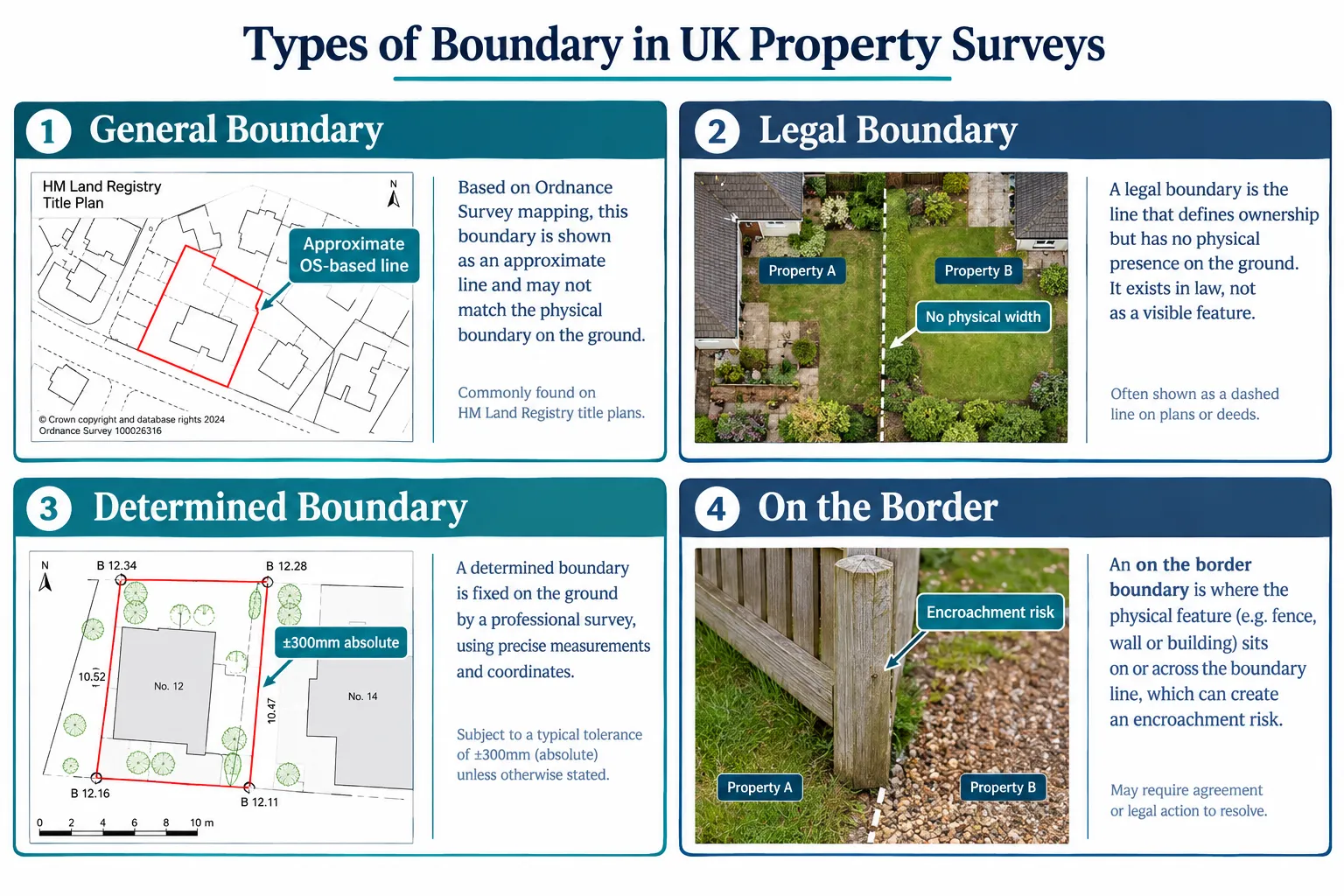
The phrase "on the border" does not appear in any statute, Land Registry practice guide or RICS professional standard. It is colloquial shorthand that surveyors, estate agents and planners sometimes use to describe a property or feature that sits very close to, or straddles, a significant line. That line could be any one of the following:
| Type of "Border" | What It Means | Who It Affects |
|---|---|---|
| Physical property boundary | A fence, wall or structure that may encroach onto a neighbour's land | Buyers, sellers, mortgage lenders |
| Local authority boundary | The property sits near the edge of one council's jurisdiction | Planning applicants, council tax payers |
| Flood risk zone boundary | The property is near the edge of a defined Environment Agency flood zone | Insurers, mortgage lenders, buyers |
| Conservation area boundary | The property is at or near the edge of a designated conservation area | Owners planning extensions or alterations |
| Valuation "borderline" | The property sits between two RICS or lender valuation bands | Valuers, lenders, shared ownership applicants |
| Planning constraint line | The property is close to a green belt edge, Article 4 direction area or similar designation | Developers, permitted development users |
Each type carries different legal, financial and practical implications. A surveyor's duty is to identify which type of "border" is relevant and to explain its significance clearly.
The Legal Boundary vs the General Boundary
HM Land Registry defines a boundary as "an imaginary or invisible line dividing one person's property from that of another", a line that has no physical thickness and is rarely identified with precision in conveyances or on the ground [8]. This distinction matters enormously.
When a property is registered at Land Registry, the title plan shows what is called a general boundary only. The red edging on a title plan is an approximation derived from Ordnance Survey mapping, not a legally guaranteed position [8]. As Practice Guide 40, Supplement 3 confirms, the exact location of a legal boundary can ultimately only be determined by a court or the Property Chamber, First-tier Tribunal [8][6].
"The boundary shown on a title plan is a general boundary only. It does not fix the precise legal boundary.", HM Land Registry, Practice Guide 40, Supplement 3 [8]
This means that when a surveyor notes that a fence, extension or outbuilding is "on the border," they are flagging that the feature sits so close to the general boundary line that it may, or may not, encroach onto a neighbour's legal boundary. The distinction between those two outcomes can be worth significant sums of money and years of litigation.
For a detailed explanation of what chartered surveyors examine during a property inspection, see what does a surveyor check: key responsibilities and inspection areas explained.
Interpreting Legal Boundaries, Valuation Zones and Planning Lines in the UK
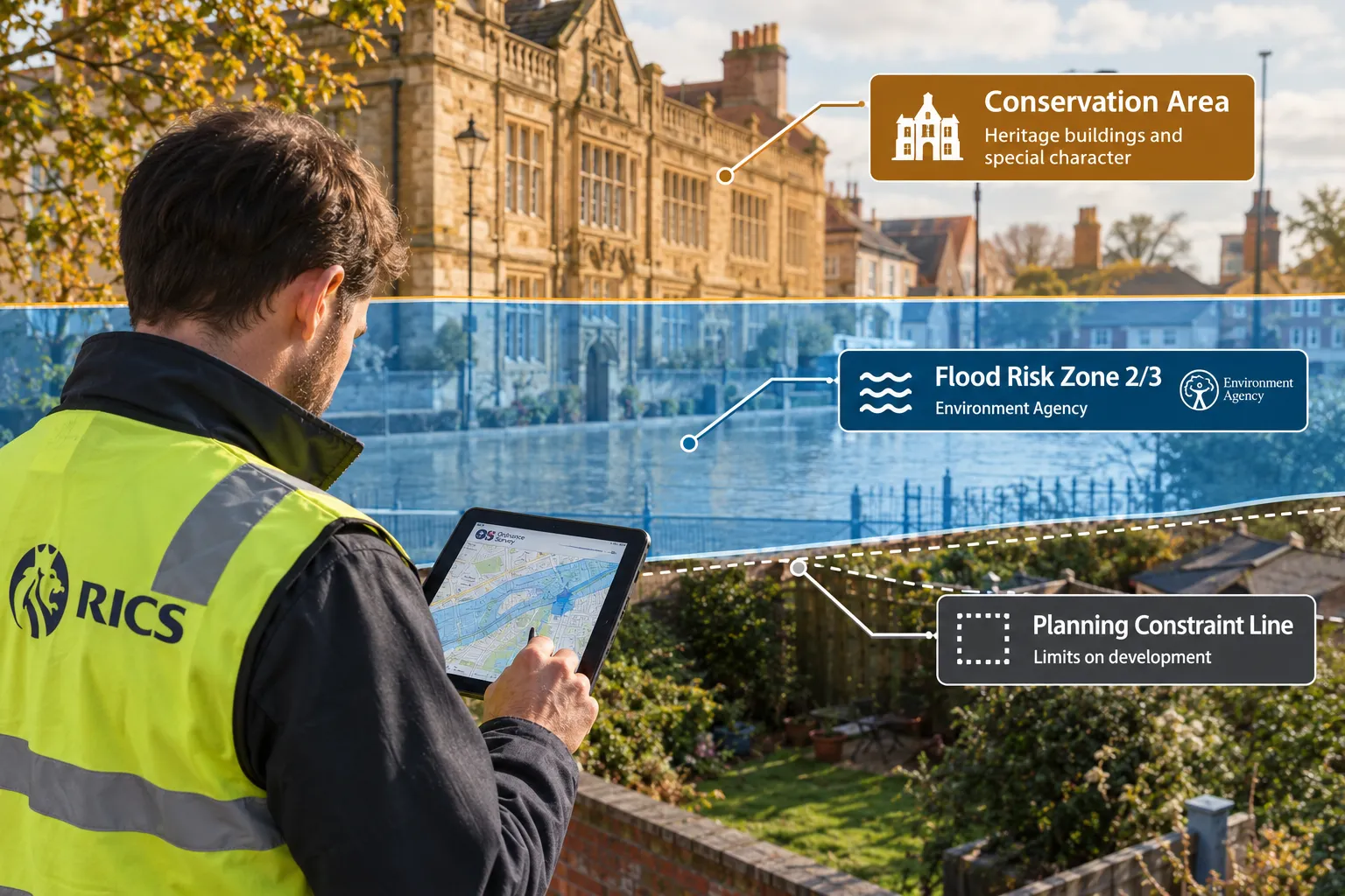
When a survey report uses "on the border" language, the reader needs to understand which of three broad categories is being invoked: a physical/legal boundary, a regulatory zone boundary, or a valuation band boundary. Each demands a different professional response.
Physical and Legal Boundary Issues
Where a structure, a garage, extension, boundary wall or outbuilding, is described as sitting "on the border," the immediate concern is encroachment. Encroachment occurs when a physical feature crosses the legal boundary and occupies land belonging to a neighbouring owner.
The RICS professional standard "Boundaries: procedures for boundary identification, demarcation and dispute resolution, 4th edition", issued as a professional standard in October 2022, sets out the authoritative step-by-step procedures for identifying boundaries on the ground, preparing compliant plans and resolving disputes [2][4]. This document is the current benchmark for all chartered surveyors handling boundary matters in England and Wales.
To fix a general boundary with precision, Land Registry's "determined boundary" regime (Practice Guide 40, Supplement 4) requires survey evidence meeting accuracy tolerances of approximately ±300 mm absolute and ±10 mm relative [8][6]. This level of precision requires a specialist topographic or boundary survey, not simply a visual inspection.
Key sources of evidence surveyors use to fix a boundary:
- The original conveyance or transfer deed and its attached plan
- HM Land Registry title plan (as a starting point, not a definitive answer)
- Historic Ordnance Survey maps
- Aerial photographs
- Physical features such as hedges, walls and ditches, interpreted in the context of the "hedge and ditch" presumption
- Witness evidence from long-standing neighbours
RICS consumer guidance updated in August 2026 stresses that assumptions based on fences or hedges can be misleading, and that early expert advice from a chartered land surveyor is essential before any dispute escalates [1].
For professional guidance on boundary surveys, specialist surveyors can provide the measured evidence needed to resolve uncertainty.
Regulatory Zone Boundaries: Flood Risk, Conservation Areas and Planning Constraints
A property described as "on the border" of a flood risk zone, conservation area or planning constraint line faces a different set of implications, but they are no less significant.
Flood Risk Zones
The Environment Agency defines flood risk zones (1, 2 and 3) based on modelled probability of flooding. A property sitting precisely on the boundary between Zone 1 (low risk) and Zone 2 (medium risk), or between Zone 2 and Zone 3 (high risk), may be classified differently by different insurers and mortgage lenders depending on which side of the line their data places it. A small shift in the zone boundary, or a more detailed local flood risk assessment, can alter insurance premiums and mortgage availability materially.
Conservation Areas
Conservation area boundaries are designated by local planning authorities under the Planning (Listed Buildings and Conservation Areas) Act 1990. Properties sitting "on the border" of a conservation area may or may not be subject to the additional permitted development restrictions that apply within the area. A single metre of difference in boundary position can determine whether a homeowner needs prior approval for works such as cladding, roof alterations or demolition of outbuildings.
Green Belt and Other Planning Constraints
Similarly, a property described as "on the border" of a green belt, Article 4 direction area or neighbourhood plan boundary may face entirely different planning rules from its immediate neighbours. Developers and buyers should always commission a planning search and, where the boundary position is genuinely unclear, seek specialist planning advice.
Local Authority Boundaries
A property straddling a local authority boundary, for example, sitting between two London boroughs, may be subject to different council tax bands, different planning policies and different infrastructure levies. This is relatively rare for individual dwellings but more common for large commercial sites or development plots.
For properties where planning constraints intersect with structural condition, a Level 2 survey or a Level 3 building survey will typically flag these zone boundaries as material considerations affecting value and future development potential.
Valuation "Borderlines": When a Property Sits Between Bands
In the context of property valuation, "on the border" takes on a subtler meaning. RICS-registered valuers and mortgage lenders use valuation bands and comparable evidence ranges to arrive at a market value. A property that sits at the very top of one comparable bracket or the very bottom of another is effectively "on the border" of two valuation outcomes.
This matters most in:
- Shared ownership valuations, where the RICS Red Book valuation determines the staircasing price
- ATED (Annual Tax on Enveloped Dwellings) valuations, where a property sitting close to a threshold (for example, near the £500,000 or £1 million mark) determines the applicable tax band
- Lease extension valuations, where the marriage value calculation is sensitive to small changes in assumed freehold value
- Mortgage valuations, where a property valued just below a lender's minimum acceptable value may trigger a retention or decline
In all these cases, the "borderline" is not a physical line on a map but a financial threshold. Instructing a RICS-registered valuer with local comparable evidence is the appropriate response when a valuation is expected to fall close to a significant threshold.
What to Do When a Survey Flags "On the Border": A Practical Guide
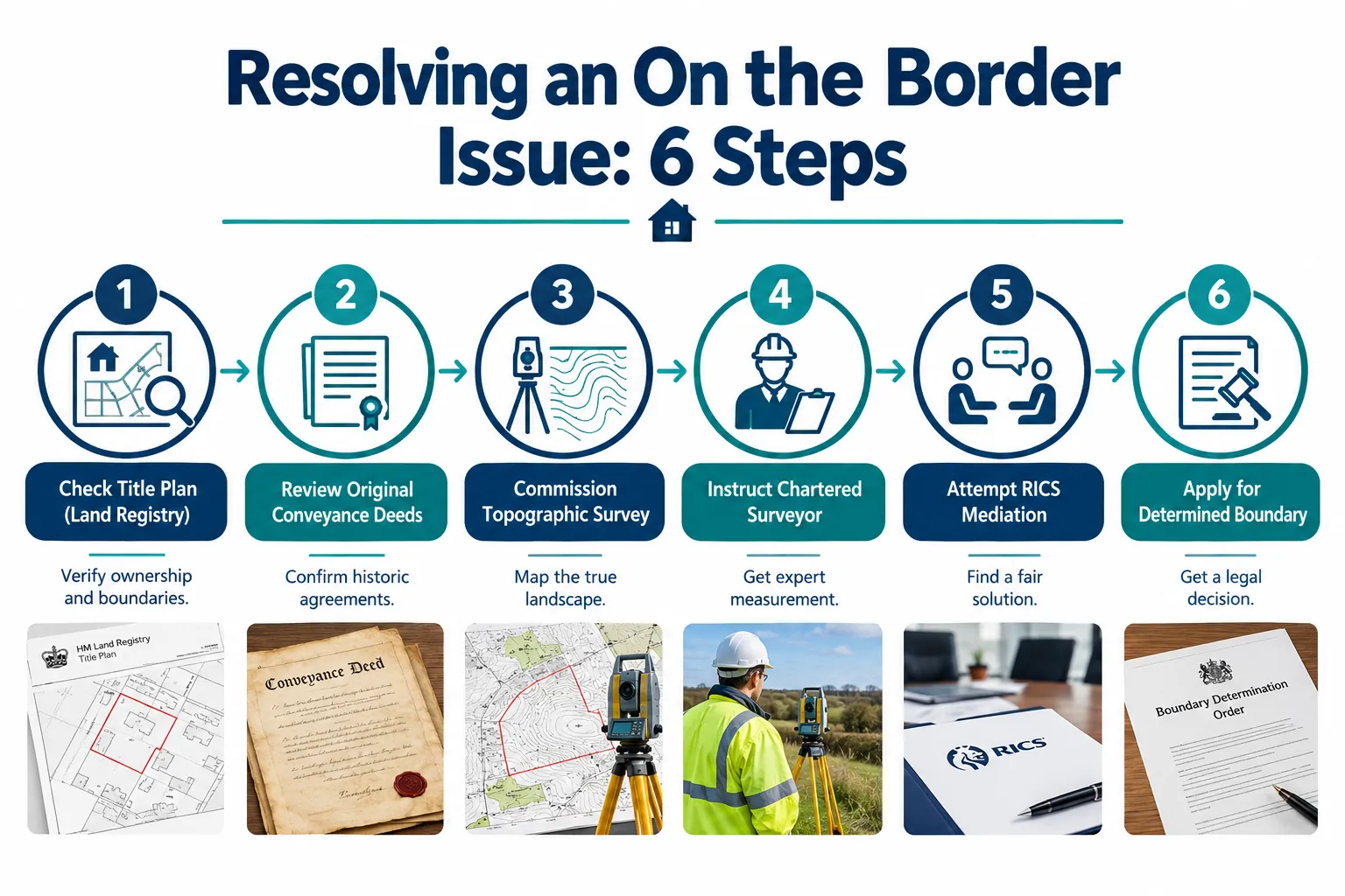
Receiving a survey report that describes a property feature as "on the border" should prompt a structured response. The following steps reflect current RICS and Land Registry best practice [1][2][8].
Step 1: Identify Which Type of "Border" Is Involved
Read the survey report carefully and ask the surveyor to clarify whether the reference is to:
- A physical encroachment onto a neighbour's land
- A proximity to a regulatory zone boundary (flood, conservation, planning)
- A valuation band threshold
- A local authority administrative boundary
The practical response differs significantly depending on the answer.
Step 2: Review the Title Documents and Conveyance Plans
Obtain the original conveyance or transfer deed, not just the Land Registry title plan, and examine the plan attached to it. The Land Registry title plan shows only a general boundary; the conveyance plan may contain more precise measurements or verbal descriptions [8][6].
Step 3: Commission a Specialist Survey Where Necessary
Where the issue involves a physical boundary, commission a topographic or boundary survey from a chartered land surveyor. RICS guidance updated in August 2026 confirms that detailed topographic surveys are particularly important when existing information is unclear, disputed, or when construction works will remove boundary features [3]. The survey provides a precise measured basis to re-establish the boundary line.
For a RICS building survey on a property where boundary encroachment is suspected, the surveyor will typically recommend a separate specialist boundary report rather than attempting to resolve the legal question within a condition survey.
Step 4: Seek Early Legal and Surveying Advice
A 2022 RICS Built Environment Journal article, still cited in current guidance, cautions professionals against underestimating boundary disputes, noting that legal costs can become disproportionate to the value at stake [9]. Early instruction of a chartered surveyor and a solicitor with property boundary experience is consistently recommended as the most cost-effective approach.
Step 5: Consider the RICS Boundary Disputes Mediation Service
Where a neighbour dispute arises over a boundary position, the RICS Dispute Resolution Service offers a structured mediation process typically lasting up to eight hours, available online or face-to-face [10]. This service is specifically designed for disputes about boundary positions, encroachment and rights of way, precisely the situations where an "on the border" description has become contentious.
Mediation is significantly cheaper than litigation and preserves the neighbourly relationship. RICS consumer guidance from August 2026 consistently recommends it as a first step before any court action [1][7].
Step 6: Apply for a Determined Boundary if Necessary
Where mediation fails or where certainty is needed for a transaction or development, the Land Registry's determined boundary regime provides a formal mechanism for converting a general boundary into a precisely fixed legal boundary. The application requires survey evidence meeting the accuracy tolerances noted above and full disclosure of any known dispute [8][6][11].
How "On the Border" Affects Property Value and Transactions
The financial implications of a property being "on the border" of any significant line are real and quantifiable.
For buyers and mortgage lenders:
A property with an unresolved boundary encroachment may be unmortgageable until the issue is resolved by a formal boundary agreement or determined boundary application. Lenders treat unresolved encroachments as a title defect.
For sellers:
Disclosure obligations under the Property Information Form (TA6) require sellers to disclose known boundary disputes. Failing to disclose a known "on the border" encroachment can expose sellers to misrepresentation claims post-completion.
For developers:
A development site that sits "on the border" of a green belt, flood zone or conservation area may have materially different planning prospects from a site sitting clearly within or outside those zones. Commissioning a desktop house valuation at the outset can help identify zone boundary risks before detailed design work begins.
For leaseholders and freeholders:
Where a property is "on the border" of a valuation threshold relevant to lease extension or freehold purchase, a small difference in the assumed freehold value can translate into a significant difference in the premium payable. Specialist lease extension valuation advice is essential in these cases.
Conclusion
The phrase "on the border" carries no single legal meaning in UK property law or surveying practice, but it consistently signals that a property, feature or valuation sits close enough to a significant line that professional scrutiny is warranted. Whether that line is a physical property boundary, a flood risk zone edge, a conservation area designation, a planning constraint or a valuation threshold, the consequences of misreading it can be substantial.
Actionable next steps for property owners and buyers in 2026:
- When a survey report uses "on the border" language, ask the surveyor to specify exactly which type of boundary or zone is involved and what evidence supports the assessment.
- Obtain and review the original conveyance or transfer deed, not just the Land Registry title plan, before drawing any conclusions about the physical boundary position.
- Commission a specialist topographic or boundary survey from a RICS-accredited chartered surveyor where physical encroachment is suspected or where construction works are planned near a boundary.
- For regulatory zone boundaries (flood, conservation, planning), obtain up-to-date searches and, where the position is genuinely ambiguous, seek specialist planning or environmental advice.
- For valuation thresholds, instruct a RICS-registered valuer with strong local comparable evidence and ask them to address the threshold risk explicitly in their report.
- Where a neighbour dispute arises, engage the RICS boundary disputes mediation service before incurring legal costs.
- If certainty is needed for a transaction or development, consider applying to Land Registry for a determined boundary.
Boundary and zone issues are technical matters that reward early, expert attention. The cost of a specialist survey is almost always a fraction of the cost of resolving a dispute that was allowed to escalate.
References
[1] Boundary Disputes England Wales – https://www.rics.org/consumer-guides/boundary-disputes-england-wales
[2] Boundaries Procedures For Boundary Identification Demarcation And Dispute Resolution Rics Guidance Note 4th Edition – https://www.rics.org/profession-standards/rics-standards-and-guidance/sector-standards/land-standards/boundaries-procedures-for-boundary-identification-demarcation-and-dispute-resolution-rics-guidance-note-4th-edition
[3] Topographic Surveys And Boundary Disputes How To Establish Your Propertys Boundaries – https://www.rics.org/consumer-guides/topographic-surveys-and-boundary-disputes-how-to-establish-your-propertys-boundaries
[4] Boundaries procedures for boundary identification demarcation and dispute resolution October 2022 – https://www.rics.org/content/dam/ricsglobal/documents/standards/Boundaries%20procedures%20for%20boundary%20identification_%20demarcation%20and%20dispute%20resolution_October%202022.pdf
[6] Land Registration Practice Guides – https://www.gov.uk/government/collections/land-registration-practice-guides
[7] Boundary Disputes Consumer Guide 2021 – https://www.rics.org/content/dam/ricsglobal/documents/consumer-guides/boundary_disputes-consumer_guide-2021.pdf
[8] Land Registry Plans Boundaries Practice Guide 40 Supplement 3 – https://www.gov.uk/government/publications/hm-land-registry-plans-boundaries-pg40s3/land-registry-plans-boundaries-practice-guide-40-supplement-3
[9] Caution Urged When Taking On Boundary Disputes – https://ww3.rics.org/uk/en/journals/built-environment-journal/caution-urged-when-taking-on-boundary-disputes.html
[10] Boundary Disputes Mediation Service – https://www.rics.org/dispute-resolution-service/drs-services/consumer-disputes/boundary-disputes-mediation-service