
{"cover":"Professional landscape format (1536×1024) hero image with bold text overlay 'Roadside Properties in the UK: How' in crisp white sans-serif on a deep navy semi-transparent overlay panel, centered with 8% safe margins from every edge. Background: bright daylight editorial photograph of a row of traditional British terraced houses directly fronting a busy dual-carriageway, with lorries and cars passing at speed, a RICS-branded surveyor in a high-visibility vest and hard hat holding a clipboard and sound level meter, shallow depth of field, warm afternoon light, magazine-cover aesthetic, professional editorial quality, teal and navy color palette.","content":["Annotated four-panel labelled infographic diagram (1536×1024) illustrating the four main road risk categories surveyors assess at UK roadside properties. Panel 1 heading 'Traffic Noise' shows a sound level meter with callout labels: 'LAeq measurement', 'Facade dB reading', 'BS 8233 threshold'. Panel 2 heading 'Structural Vibration' shows a masonry wall cross-section with callout labels: 'BS 6472 criteria', 'Ground-borne waves', 'Crack monitoring'. Panel 3 heading 'Highway Safety' shows a property setback diagram with labels: 'Visibility splay', 'Crash barrier zone', 'Setback distance'. Panel 4 heading 'Air Quality' shows a pollution gradient arrow with labels: 'NO2 proximity', 'PM2.5 levels', 'Prevailing wind'. Clean white background, teal-and-navy palette, thin callout lines, editorial infographic polish, all labels inside 5% safe margin.","Split-screen landscape editorial image (1536×1024). Left half: close-up documentary photograph of a RICS chartered surveyor, a middle-aged South Asian woman, using a calibrated handheld vibration meter pressed against the external brick wall of a Victorian terraced house, with a busy road visible in the background, natural daylight, shallow depth of field, warm tones. Right half: annotated step-by-step flow diagram showing the surveyor assessment process: Step 1 'Site Inspection', Step 2 'Noise Measurement', Step 3 'Vibration Analysis', Step 4 'RICS Report', Step 5 'Valuation Adjustment', each step in a numbered teal circle connected by arrows, short 3-word labels, clean white background, navy typography, editorial quality, no overlapping text.","Cinematic landscape editorial photograph (1536×1024) showing a wide-angle view of a modern UK highway with noise barrier walls, grey concrete panels topped with transparent acrylic sections, running alongside a row of semi-detached suburban homes, shot from ground level at dusk with warm amber streetlights beginning to glow, a young Black male surveyor in the foreground reviewing a laptop showing a noise contour map overlaid on a satellite image of the properties, dramatic contrast between the industrial road infrastructure and the residential setting, rich moody color grade with teal highlights, magazine-quality depth and composition, no text overlay required."]
Roughly 1.7 million homes in England alone sit within 150 metres of a major A-road or motorway, yet the full range of risks those locations carry is routinely underestimated at the point of purchase. Roadside properties in the UK: how surveyors assess 'road' risks from noise, safety and structural vibration is a subject that touches everything from daily quality of life to long-term structural integrity and resale value. A buyer who commissions only a basic mortgage valuation may never learn that the property sits inside a designated Noise Important Area, that heavy goods vehicles are generating ground-borne vibration above BS 6472 comfort thresholds, or that the highway boundary sits uncomfortably close to a load-bearing wall.
This article explains precisely what a competent RICS-qualified surveyor investigates when assessing a property beside a busy road, why those checks matter more than ever in 2026, and what buyers, owners and valuers should do with the findings.
Key Takeaways
- Road noise, structural vibration, highway safety, air quality and access rights are all distinct risk categories that surveyors must investigate separately at roadside properties.
- Current government figures for noise disamenity are estimated to be up to 12 times lower than what households actually require as compensation, meaning road noise is a far larger value detractor than official guidance implies [9].
- BS 6472 and BS 8233 are the primary technical standards against which vibration and internal noise levels are assessed at UK roadside buildings.
- The Department for Transport's updated Noise Action Plans, due for consultation in 2026, will redefine which properties fall inside Noise Important Areas and may trigger new mitigation requirements [9].
- A Level 3 Building Survey (formerly Full Structural Survey) is the most appropriate survey type for properties with significant road exposure, and specialist acoustic or vibration reports may be needed alongside it.
Why Road Proximity Is a More Complex Risk Than Most Buyers Realise
The instinct to dismiss a roadside location as simply "noisy" misses the breadth of what proximity to a busy highway actually means for a building and its occupants. Surveyors working on roadside properties in the UK assess 'road' risks from noise, safety and structural vibration as a cluster of interrelated but technically distinct hazards, each requiring its own methodology.
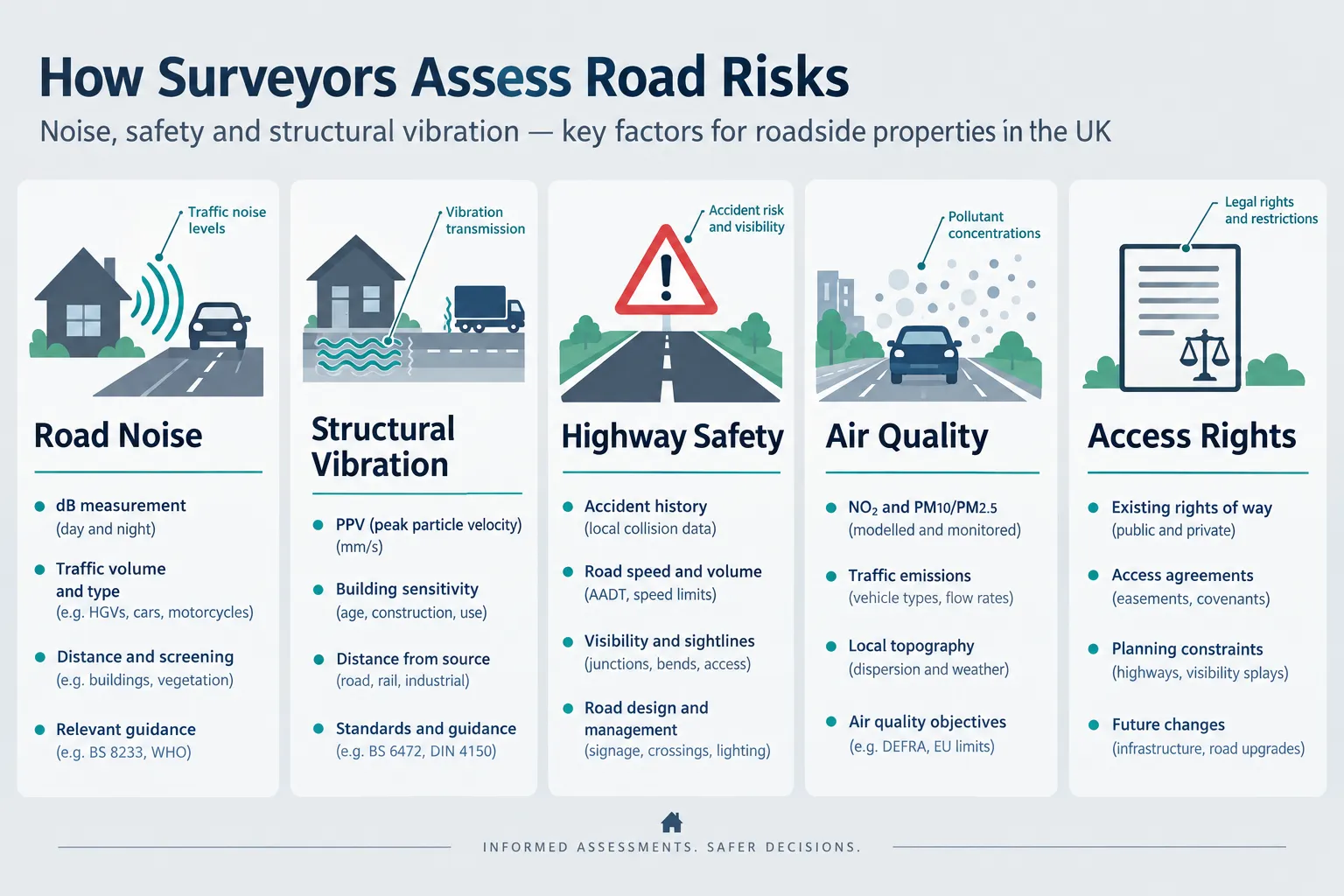
The five core risk categories a surveyor considers are:
| Risk Category | Primary Concern | Key Standard or Reference |
|---|---|---|
| Traffic noise | Occupant amenity, sleep disturbance | BS 8233, WHO guidelines |
| Structural vibration | Building fabric damage, occupant comfort | BS 6472 |
| Highway safety | Vehicle incursion, visibility, crash risk | Highways Act 1980, DMRB |
| Air quality and contamination | Health, surface degradation | NPPF, local authority data |
| Access, parking and highway rights | Legal title, future development | Land Registry, highway records |
Each category can independently affect value. Together, they can make a property significantly less desirable, or, where mitigation is already in place, more resilient than a naive assessment would suggest.
The Policy Context in 2026
The Department for Transport's "Better Connected" integrated transport strategy confirms that National Highways delivered noise mitigation in Noise Important Areas throughout the Road Investment Strategy 2 period (2020-2025) and will continue a risk-based approach under Road Investment Strategy 3, running to 2030/31 [9]. Critically, updated Noise Action Plans for road, rail and urban areas are due for consultation in 2026, which will directly influence how local authorities and consultants prioritise mitigation near dwellings [9].
For surveyors, this policy shift has a practical implication: a property that currently sits just outside a Noise Important Area could fall within one under revised thresholds. Conversely, a property that already benefits from a noise barrier or low-noise road surface may carry a lower risk profile than its location alone would suggest. Checking the current and proposed Noise Important Area boundaries is now a standard due-diligence step.
It is also worth noting that the rise of electric vehicles will not eliminate roadside noise risks. "Better Connected" explicitly acknowledges that while EVs reduce some noise, mitigation across the whole transport network remains necessary, tyre and road-surface noise dominate at speeds above roughly 30 mph regardless of powertrain [9]. Surveyors should treat any EV-related noise reduction as incremental rather than transformative when appraising properties near fast-moving roads.
How Surveyors Technically Assess Road Noise at UK Properties
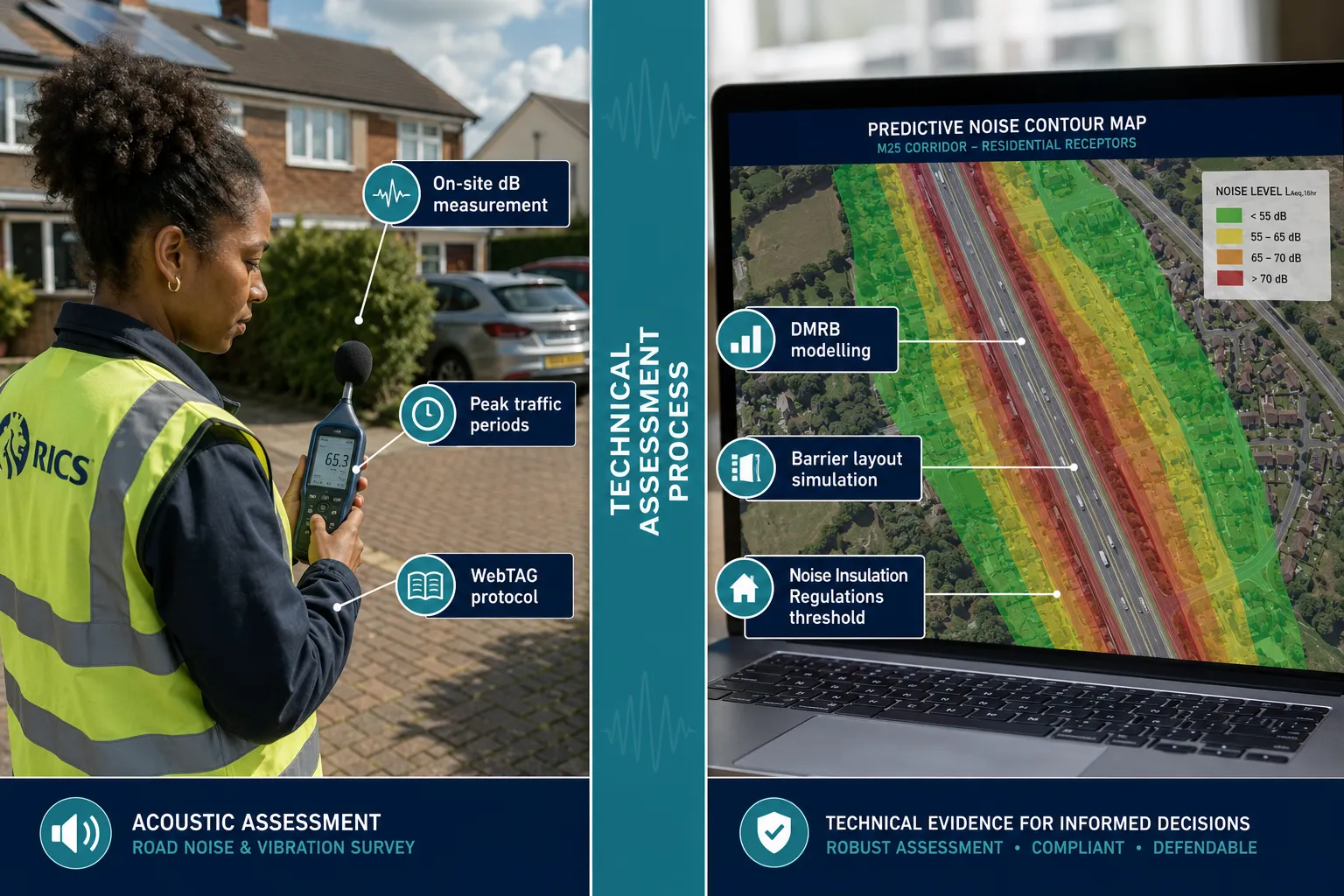
Acoustic assessment of a roadside property typically combines on-site measurement with predictive modelling. Specialist firms use WebTAG, the Design Manual for Roads and Bridges (DMRB) and the Noise Insulation Regulations when dealing with new or altered highway schemes, and they offer barrier layout recommendations for individual homeowners [4]. The key metrics collected are:
- LAeq (equivalent continuous sound level): the average noise energy over a defined period, usually 16 hours daytime (07:00-23:00) and 8 hours night-time. BS 8233 recommends indoor LAeq values of no more than 35 dB for bedrooms at night.
- Lmax: the maximum instantaneous level, relevant where individual lorry or bus pass-bys cause sudden disturbance.
- L10 and L90: statistical descriptors used in older UK road traffic noise assessments under the Calculation of Road Traffic Noise (CRTN) methodology.
Measurements are taken at the building facade and, where access is granted, within habitable rooms. Road traffic noise and vibration control specialists measure these parameters to determine how sites are affected by existing sources and to recommend control measures [1]. Impact assessments are produced for planning applications, lease renewals and litigation support [2].
"Official UK valuations of noise disamenity at properties may be far too low. A previously unpublished DfT study found households require at least £900 (2025 prices) to accept a 1 dB increase above 56 dB, around 12 times higher than the current government TAG value of £75." [9]
This finding has direct implications for surveyors preparing RICS Red Book valuations. The August 2026 update to RICS Valuation, Global Standards reorganises valuation practice statements, including VPS 4 on inspections, investigations and records, and VPS 6 on valuation reports, clarifying what valuers must document when environmental factors affect value. Proximity to a busy road, exposure to traffic noise and vibration must now be systematically recorded and reflected in assumptions and special assumptions for roadside assets.
For buyers considering properties in areas with significant road exposure, a full structural survey sample and comprehensive guide illustrates the level of detail a Level 3 report should contain, including environmental risk commentary.
Structural Vibration: The Risk That Buyers Most Often Overlook
Ground-borne vibration from heavy vehicles is the road risk that buyers are least likely to notice during a brief viewing but most likely to regret ignoring. A loaded HGV passing over a pothole or expansion joint generates low-frequency vibration that travels through the ground and into a building's foundations. At low levels this is merely annoying; at sustained or high levels it can loosen mortar joints, widen existing cracks and accelerate the deterioration of older masonry.
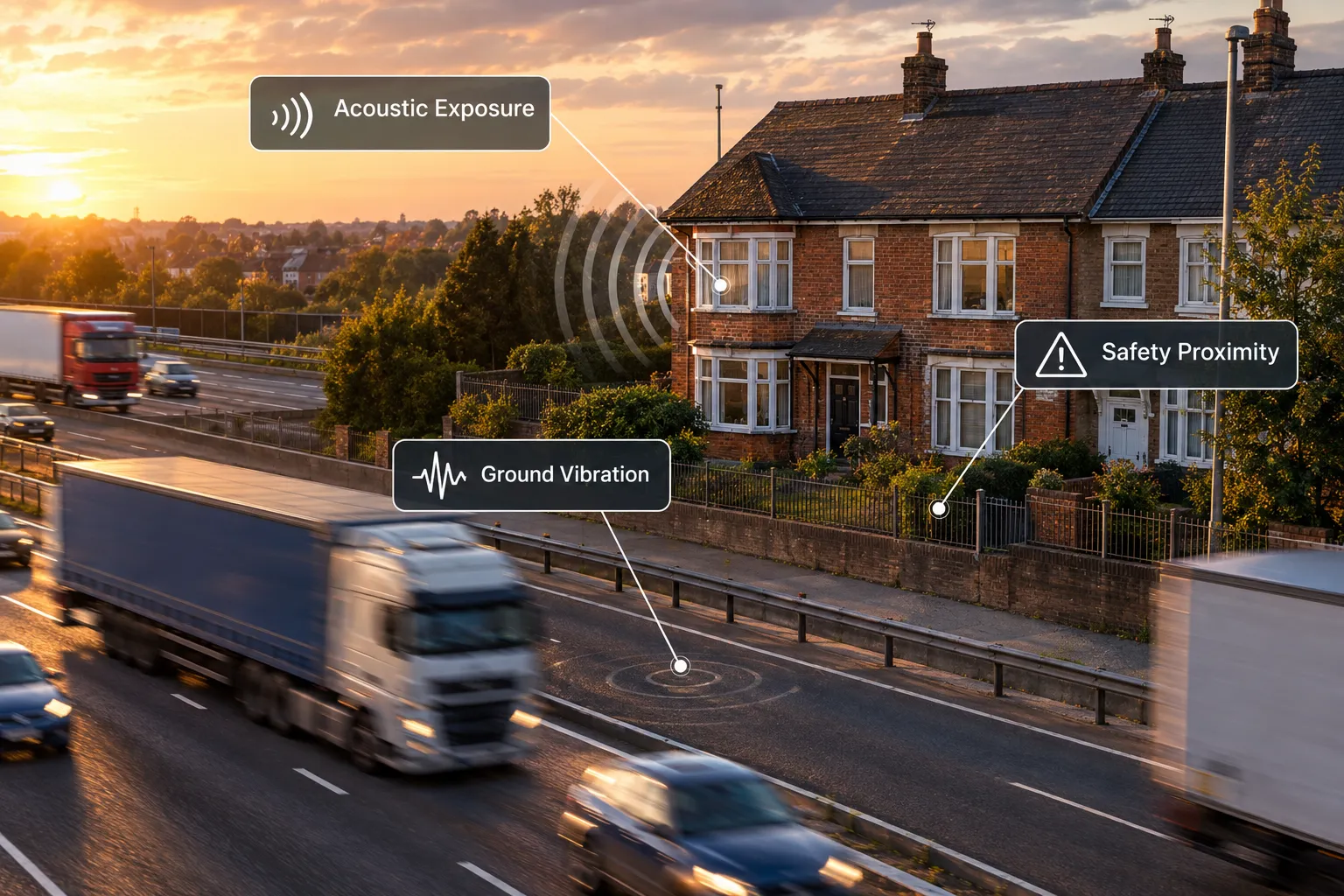
BS 6472 and What It Means in Practice
The primary standard for assessing human exposure to vibration in buildings is BS 6472, which sets vibration dose values (VDVs) for different times of day and building uses. Surveyors and acoustic specialists assess vibration to BS 6472 alongside road traffic noise measurements, PPG24 noise impact assessments and internal noise assessments to BS 8233 [10]. The process involves:
- Baseline measurement using a calibrated accelerometer placed on the building floor slab or ground-floor structure, with data logged over a representative traffic period.
- Frequency weighting to reflect human perception across the 1-80 Hz range.
- VDV calculation and comparison with BS 6472 thresholds for "low probability of adverse comment" (residential daytime: 0.2-0.4 m/s^1.75^) and higher thresholds where complaint is likely.
- Structural assessment where VDVs are elevated, checking whether existing cracks or defects in masonry could be linked to vibration history.
UKAS-accredited laboratories calibrate the instruments used in these surveys, with standard five-day turnarounds, facilitating compliant and traceable data collection for planning applications, legal disputes or occupational health assessments [7]. Traceability matters: if a buyer later pursues a claim against a highway authority or developer, measurements taken with calibrated, accredited equipment carry significantly more weight.
For properties where vibration-related cracking is suspected, a dedicated structural crack assessment by RICS surveyors can determine whether defects are cosmetic, progressive or structurally significant, and whether road traffic is a contributing cause.
Noise and vibration services are also used to secure regulatory approval for new developments near existing roads, meaning that proposed roadside builds or extensions may need vibration assessments as part of the planning process [6]. Owners planning rear extensions or loft conversions on roadside properties should factor this in early.
Highway Safety, Access Rights and Structural Proximity
Roadside properties in the UK face 'road' risks from noise, safety and structural vibration that extend beyond acoustics into legal and physical safety territory. A surveyor conducting a Level 3 Building Survey will examine several highway-related factors that rarely appear in a mortgage valuation.
Vehicle Incursion and Physical Protection
Properties directly fronting high-speed roads face a genuine vehicle incursion risk. Surveyors check:
- Setback distance from the carriageway edge to the building line, and whether any protective barrier (crash barrier, bollards, substantial wall) is present.
- Condition of boundary walls and fences facing the road, noting impact damage, previous repairs and adequacy of height.
- Evidence of past incidents, such as scuff marks, replaced brickwork or temporary repairs to gate posts.
Where a property sits on a bend, at the exit of a slip road or near a junction, the risk of vehicle incursion is materially higher and should be flagged explicitly in the survey report.
Highway Boundary and Adoption Status
The legal boundary between a property and the public highway is not always where it appears. Surveyors advise buyers to verify:
- Highway adoption records (Section 38 agreements for new roads, Section 278 for works to existing roads) to confirm which party is responsible for the carriageway, footway and verge.
- Ransom strips, narrow strips of unadopted land between a property and the highway that could affect access rights or future development value.
- Visibility splays required by planning conditions, which may restrict what a buyer can build or plant near the road frontage.
Parking, Access and Dropped Kerbs
Parking provision at roadside properties is frequently constrained. A surveyor will note whether a dropped kerb and vehicle crossover are formally approved by the highway authority, as an unapproved crossing can expose the owner to enforcement action and repair liability. In areas of controlled parking, the absence of a resident permit zone space can significantly affect both liveability and value.
For properties in areas with high road exposure across the Home Counties, chartered surveyors in Surrey and chartered surveyors in Essex regularly encounter these highway boundary issues on properties fronting A-roads and trunk roads.
Air Quality, Contamination and Surface Degradation
Properties within approximately 200 metres of a busy road are exposed to elevated concentrations of nitrogen dioxide (NO2), particulate matter (PM2.5 and PM10) and, in older urban areas, residual lead contamination from pre-1999 leaded petrol. While air quality assessment sits primarily within the remit of environmental consultants, a surveyor will note:
- Soiling and staining on facades, particularly on the windward elevation facing the road.
- Degradation of pointing, render and window frames accelerated by exhaust particulates and road spray.
- Garden and soft landscaping that may have absorbed years of road runoff, relevant where a buyer intends to grow food.
Local authority air quality management areas (AQMAs) are publicly searchable and should be checked as part of pre-survey desktop research. A property within an AQMA may face future planning restrictions on certain uses or extensions.
How Road Risks Are Reported in Building Surveys and Valuations
The way road risks are communicated in a survey report matters as much as the findings themselves. Under the RICS Home Survey Standard, Level 2 (HomeBuyer Report) and Level 3 (Building Survey) reports use a traffic-light condition rating system (1 = no repair needed, 2 = repair or replacement needed but not urgent, 3 = urgent repair or replacement required). Road-related risks typically appear under:
- Section E (Outside the property): boundary walls, fences, highway proximity.
- Section F (Outside walls): facade condition, vibration-related cracking.
- Section J (Issues for your legal advisers): highway adoption, access rights, ransom strips.
- Section K (Risks): noise, vibration, air quality, vehicle incursion risk.
A Level 3 Building Survey is the appropriate choice for any property with direct road frontage onto a classified road, a property showing signs of vibration-related cracking, or a property within a designated Noise Important Area.
For a detailed breakdown of what each survey level covers, the Level 2 vs Level 3 survey comparison explains the key differences and helps buyers choose the right level of investigation.
Valuation Adjustments for Road Exposure
RICS Red Book valuations must document environmental factors that affect value. The evidence base for quantifying road noise as a value detractor is growing: a previously unpublished DfT study found that households require compensation for noise exposure that is many multiples of current official TAG values, with implications for all transport noise valuations [9]. Valuers are expected to apply a reasoned adjustment, typically expressed as a percentage below comparable properties in quieter locations, and to document the basis for that adjustment clearly.
For major infrastructure schemes, continuous noise and vibration monitoring at nearby properties is now standard practice, as demonstrated by the HS2 Phase One monthly monitoring reports, which provide time-history data for noise and ground vibration at residential receptors along the London, West Midlands route [3]. This sets a benchmark for the level of evidence that can be expected in high-stakes roadside assessments.
Buyers wanting to understand the full cost of commissioning the right level of survey can review current building survey costs for 2026, which covers pricing for Level 2 and Level 3 reports as well as specialist add-ons.
For properties in specific locations with high road exposure, local expertise is invaluable. Chartered surveyors in Guildford and chartered surveyors in Kingston upon Thames regularly assess properties along major commuter routes where road noise and vibration are recurring concerns.
The Outlook for Roadside Property Assessment
The regulatory and policy environment for roadside property assessment is tightening. Several converging trends will shape practice over the next two to three years:
Updated Noise Action Plans (2026-2027). The DfT has committed to publishing updated Noise Action Plans for road, rail and urban areas for consultation in 2026 [9]. Once finalised, these will redefine Noise Important Area boundaries and may introduce tighter thresholds for action, directly affecting which properties qualify for mitigation and how surveyors must describe noise risk in reports.
Growing pressure on noise valuations. The evidence that official noise disamenity values are a fraction of households' genuine willingness-to-accept figures [9] is likely to feed into future RICS guidance and court decisions on diminution in value claims. Surveyors who have relied on minimal noise adjustments in valuations may face challenge.
More rigorous monitoring expectations. The HS2 monthly noise and vibration monitoring programme [3] illustrates the direction of travel for major schemes. As monitoring technology becomes cheaper and more accessible [7], there will be growing expectation that roadside assessments are supported by measured data rather than desk-based estimates alone.
Broader noise policy pressure. Political scrutiny of community noise impacts, visible in debates around Heathrow expansion and the London Mayor's calls for stronger mitigation [9], is creating a climate in which road noise is treated as a serious public health issue rather than an accepted nuisance. This is likely to translate into more robust planning conditions and stronger buyer awareness.
For owners considering structural alterations to roadside properties, structural engineering services can assess whether proposed works are compatible with the vibration and loading environment created by adjacent traffic.
Conclusion
Roadside properties in the UK present a layered set of risks that go well beyond the noise a buyer notices during a viewing. Surveyors assessing 'road' risks from noise, safety and structural vibration must work systematically across five distinct categories, acoustic exposure, ground-borne vibration, highway safety, air quality and legal access, and communicate findings clearly in reports that comply with RICS standards.
Actionable next steps for buyers and owners:
- Commission a Level 3 Building Survey for any property with direct frontage onto a classified road or showing signs of vibration-related cracking. Do not rely on a Level 2 report or mortgage valuation alone.
- Request specialist acoustic and vibration assessments where the property is within 200 metres of a motorway, trunk road or heavily trafficked urban route, or where BS 6472 thresholds may be breached.
- Check Noise Important Area designations with the relevant local authority or National Highways, and monitor the DfT's 2026 Noise Action Plan consultation for any changes to boundaries.
- Verify highway boundaries and adoption status through Land Registry title plans and highway authority records before exchange of contracts.
- Ensure the valuation reflects genuine noise disamenity, asking the valuer to document the basis for any road-noise adjustment in line with RICS Red Book VPS 4 and VPS 6 requirements.
- Seek local expertise. Surveyors with deep knowledge of specific road corridors, whether in Surrey, Essex, Guildford or Kingston, will have the most relevant comparable evidence and local policy knowledge to support a well-grounded assessment.
Taking these steps turns road proximity from an unquantified anxiety into a managed, documented risk, and gives buyers, owners and lenders the evidence base they need to make informed decisions.
References
[1] Road Traffic Noise – https://www.noise-and-vibration.co.uk/road-traffic-noise/
[2] Environmental Noise – https://www.impactacoustics.co.uk/environmental-noise
[3] Monitoring Noise And Vibration On The Hs2 Phase One Route June 2026 – https://www.gov.uk/government/publications/monitoring-noise-and-vibration-on-the-hs2-phase-one-route-june-2026
[4] Noise Vibration – https://www.accon-uk.com/noise-vibration/
[6] Noise Vibration – https://www.ikmconsulting.co.uk/noise-vibration/
[7] Road Traffic Noise – https://www.noise-and-vibration.co.uk/road-traffic-noise/
[9] DfT Better Connected A Strategy For Integrated Transport – https://assets.publishing.service.gov.uk/media/69de12cb961ff0ba6bff8de9/dft-better-connected-a-strategy-for-integrated-transport.pdf
[10] MRL Acoustics Ltd – https://www.linkedin.com/company/mrl-acoustics-ltd