
{"cover":"Professional landscape format (1536×1024) hero image featuring bold text overlay 'Drones in Land Surveying: UAV Innovations Reducing Costs and Boosting Accuracy in 2026' in extra large 72pt white sans-serif font with dark shadow and subtle blue gradient background box, positioned in upper third. Background shows advanced quadcopter drone with LiDAR sensor hovering over topographic survey site with visible terrain mapping grid overlay, construction site below, surveyor holding tablet displaying 3D terrain model. Color scheme: deep blue sky, white text, orange safety accents, green terrain visualization. High contrast, magazine cover quality, editorial style with technical precision. Composition includes GPS satellite signals illustrated as geometric lines, real-time kinematic positioning indicators, and modern surveying equipment. Professional, cutting-edge technology aesthetic.","content":["Detailed landscape format (1536×1024) image showing split-screen comparison of traditional land surveying versus drone surveying methods. Left side: traditional surveyors with tripod-mounted total station equipment, measuring tape, multiple crew members on challenging terrain, time-consuming manual process. Right side: single operator with tablet controlling DJI enterprise drone equipped with RTK positioning system, real-time 3D orthomosaic map displayed on screen, efficient aerial coverage pattern illustrated with flight path lines. Include cost comparison infographic overlay showing '$80,000+ annual savings' in bold text, efficiency metrics with clock icons showing 'days vs hours' comparison. Professional surveying aesthetic with high-visibility safety vests, construction site background, clear blue sky, technical precision.","Detailed landscape format (1536×1024) technical illustration showing drone-based LiDAR scanning technology in action. Central focus: professional survey-grade UAV with visible LiDAR sensor array emitting green laser scanning beams penetrating dense forest canopy to reveal ground surface below. Split visualization showing raw point cloud data on left transforming into colorful digital elevation model (DEM) on right with elevation gradients in blue-to-red spectrum. Include PPK/RTK satellite positioning indicators, accuracy measurement annotations showing centimeter-level precision, 3D terrain mesh overlay. Background shows diverse applications: archaeological site mapping, infrastructure inspection, vegetation analysis. Technical diagrams with measurement annotations, professional GIS software interface elements, modern surveying technology aesthetic.","Detailed landscape format (1536×1024) infographic-style image illustrating regulatory compliance and best practices for drone surveying operations in 2026. Central element: checklist tablet display showing key compliance items with checkmarks – CAA registration, operator certification, flight permissions, insurance requirements, data protection protocols. Surrounding visual elements: drone pilot with proper credentials badge, no-fly zone map overlay with restricted airspace marked in red, safety equipment including high-visibility vest and first aid kit, pre-flight inspection checklist, weather monitoring app on smartphone. Include workflow diagram showing survey planning, flight execution, data processing, and deliverable creation stages. Professional training certification symbols, regulatory compliance badges, best practice icons. Clean, organized layout with blue and orange color scheme, professional surveying industry aesthetic, educational infographic style."]
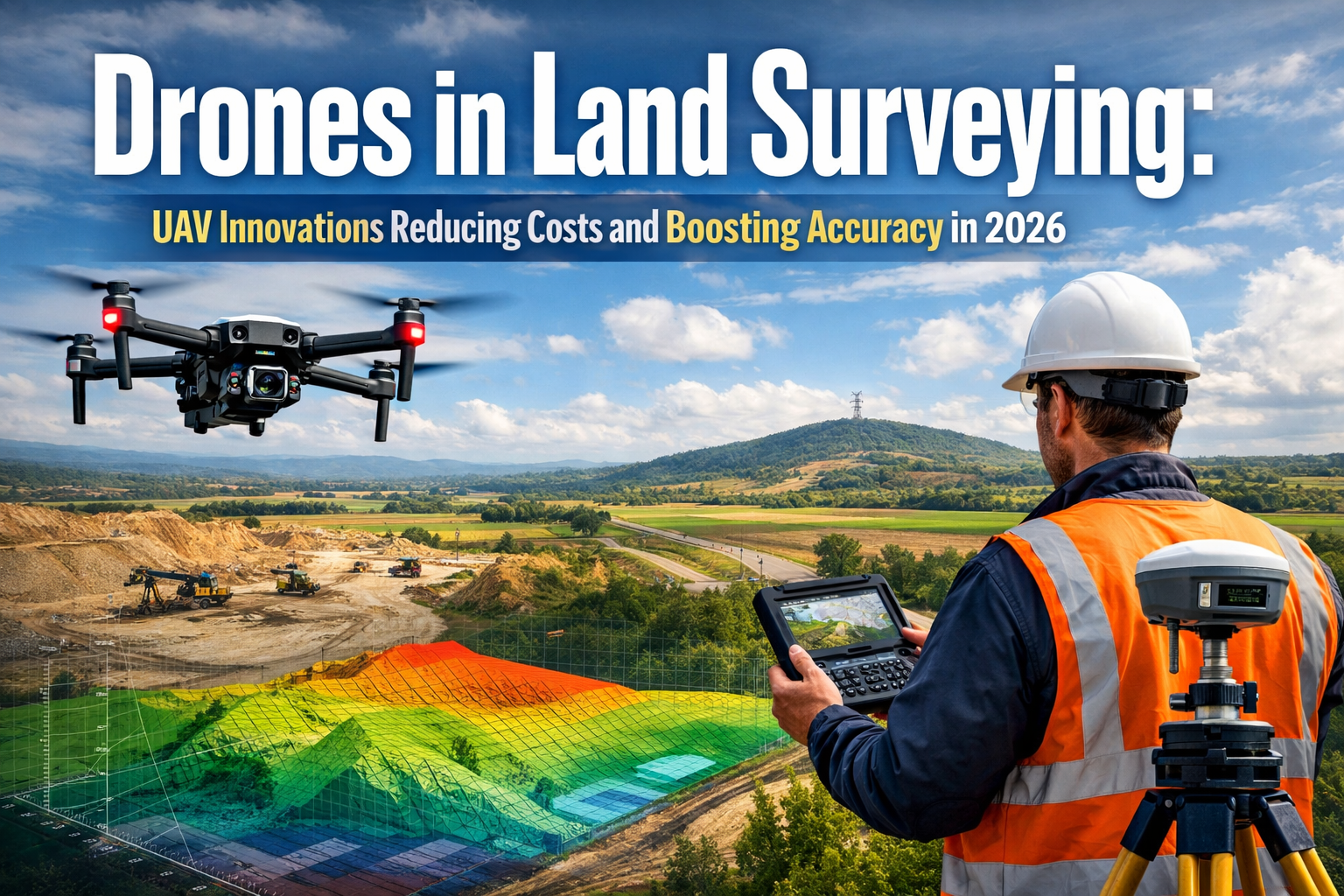
The surveying industry is experiencing a technological revolution that would have seemed impossible just a decade ago. Picture a single operator controlling an unmanned aerial vehicle (UAV) equipped with advanced sensors, completing in mere hours what previously required a team of surveyors working for days or even weeks. This transformation isn't science fiction—it's the reality of Drones in Land Surveying: UAV Innovations Reducing Costs and Boosting Accuracy in 2026. As traditional surveying methods give way to cutting-edge aerial technology, professionals across construction, environmental monitoring, mining, and urban planning are discovering unprecedented efficiency gains and cost reductions that are fundamentally reshaping how we measure and map our world.
The adoption of drone technology in surveying has skyrocketed from experimental curiosity to industry standard, driven by compelling economics and remarkable accuracy improvements. Environmental engineering firms are documenting savings exceeding $80,000 annually through drone integration[4], while projects that once demanded extensive ground crews now require minimal personnel. Combined with breakthrough innovations in LiDAR integration, GPS-denied area sensors, and real-time kinematic positioning, drones have evolved from simple aerial cameras into sophisticated data collection platforms capable of centimeter-level precision across diverse terrain and challenging environments.
Key Takeaways
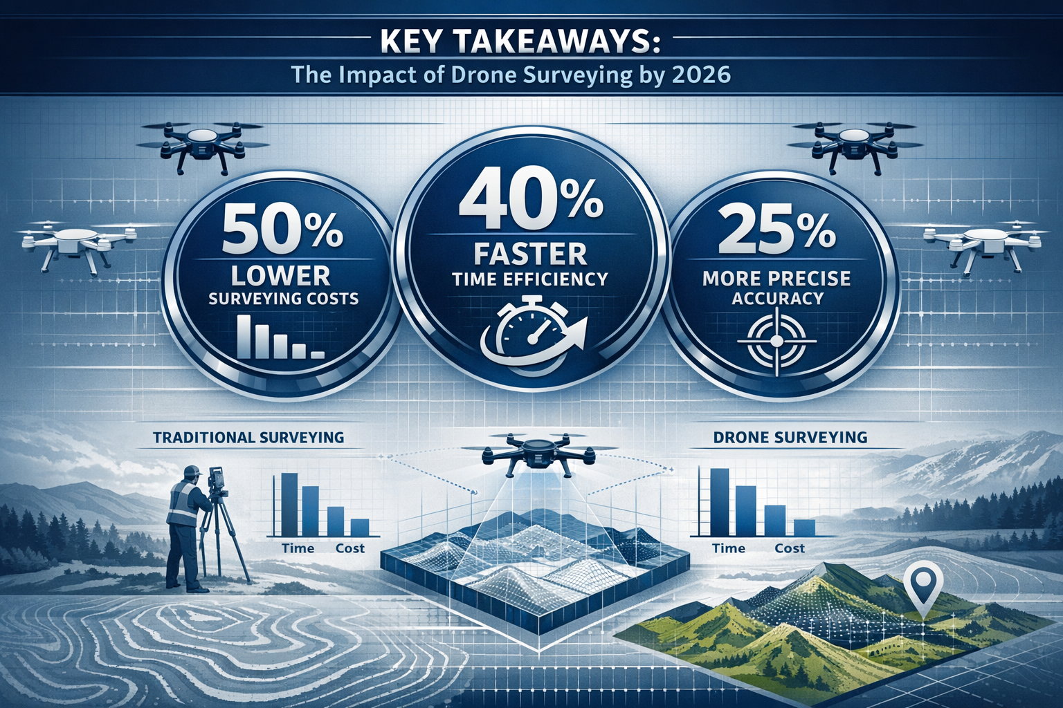
✅ Dramatic cost reduction: Drone surveying requires significantly fewer personnel and equipment than traditional methods, with documented cases showing annual savings exceeding $80,000 through operational efficiency[4]
✅ Speed advantage: UAV technology completes large-area surveys in hours compared to days or weeks required by ground-based approaches, accelerating project timelines across industries[1]
✅ Enhanced accuracy through sensor fusion: Modern drones integrate LiDAR, RTK/PPK positioning, and multispectral imaging to achieve centimeter-level precision while penetrating vegetation and operating in GPS-denied environments[2][3]
✅ Expanded capabilities: 2026 survey drones perform photogrammetry, 3D mapping, thermal imaging, and building information modeling (BIM), providing comprehensive data sets for diverse applications[2]
✅ Safety improvements: Aerial data collection eliminates risks associated with hazardous terrain, busy roads, and challenging environments, reducing on-site injuries while maintaining data quality[1]
Understanding the Drone Surveying Revolution: From Niche Technology to Industry Standard
The Traditional Surveying Challenge
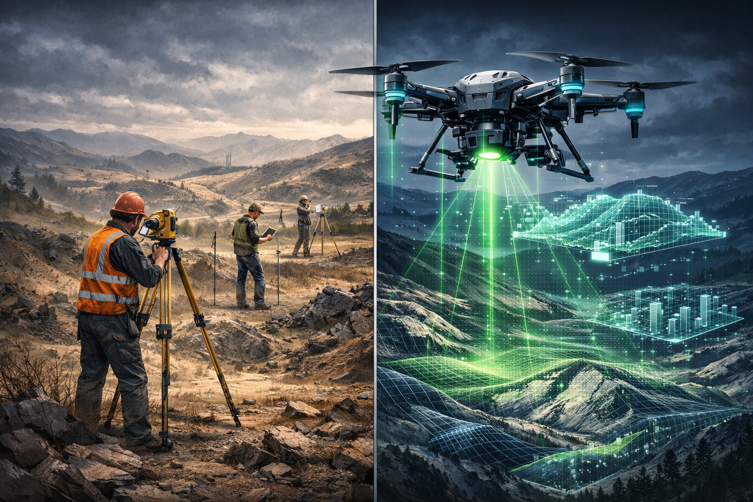
Traditional land surveying methods have served the construction, engineering, and planning industries for generations, but they come with inherent limitations. Ground-based surveys require multiple crew members equipped with total stations, GPS receivers, and measuring equipment to physically access every point of interest across a project site. This approach proves particularly challenging when dealing with:
- Large geographical areas requiring extensive time and labor
- Hazardous terrain including steep slopes, unstable ground, or contaminated sites
- Dense vegetation obscuring ground-level measurements
- Active construction zones with safety risks and access restrictions
- Remote locations with difficult logistics and transportation costs
The time investment alone creates significant project delays. A comprehensive topographic survey of a 100-acre site using traditional methods might require a team of 3-5 surveyors working for several days, with additional time needed for data processing and map creation. When you factor in equipment costs, personnel expenses, transportation, and the opportunity cost of delayed project timelines, the financial burden becomes substantial.
How Drones Transform the Surveying Workflow
Drones in Land Surveying: UAV Innovations Reducing Costs and Boosting Accuracy in 2026 represent a fundamental shift in methodology rather than simply a new tool. Modern UAV surveying workflows typically follow this streamlined process:
- Pre-flight planning: Operators use specialized software to design automated flight paths that ensure complete coverage with appropriate overlap for photogrammetric processing
- Rapid data capture: The drone autonomously flies the planned route, capturing hundreds or thousands of high-resolution images or LiDAR point clouds in a fraction of the time required for ground surveys[1]
- Automated processing: Specialized software transforms raw imagery into orthomosaic maps, digital elevation models (DEMs), and 3D terrain models[5]
- Analysis and deliverables: Survey teams validate data accuracy and create final deliverables including contour maps, volume calculations, and CAD-compatible files
This workflow transformation enables a single qualified operator to accomplish what previously required an entire survey crew. The efficiency gains translate directly to cost savings—one documented case study involving environmental engineering firm Dudek demonstrated annual savings exceeding $80,000 through drone and GIS integration[4].
Quantifying the Cost Advantages
The economic case for drone adoption in surveying becomes compelling when examining specific cost components:
Personnel costs: Traditional surveys require 3-5 qualified surveyors on-site for extended periods. Drone operations typically require 1-2 operators, dramatically reducing labor expenses.
Equipment investment: While professional survey-grade drones represent a significant upfront investment (£5,000-£50,000 depending on sensors and capabilities), this cost compares favorably to maintaining multiple sets of traditional surveying equipment and vehicles.
Time efficiency: Projects that required days or weeks of fieldwork now complete in hours[1]. This time compression reduces not only direct labor costs but also indirect expenses like accommodation, transportation, and equipment rental.
Safety-related costs: By eliminating the need for surveyors to access hazardous areas, drones reduce insurance premiums, workers' compensation claims, and safety equipment requirements[1].
For surveyors considering the transition to UAV technology, understanding topographic survey costs provides essential context for evaluating the return on investment.
Breakthrough Technologies Driving Accuracy Improvements in 2026
LiDAR Integration: Seeing Through the Canopy
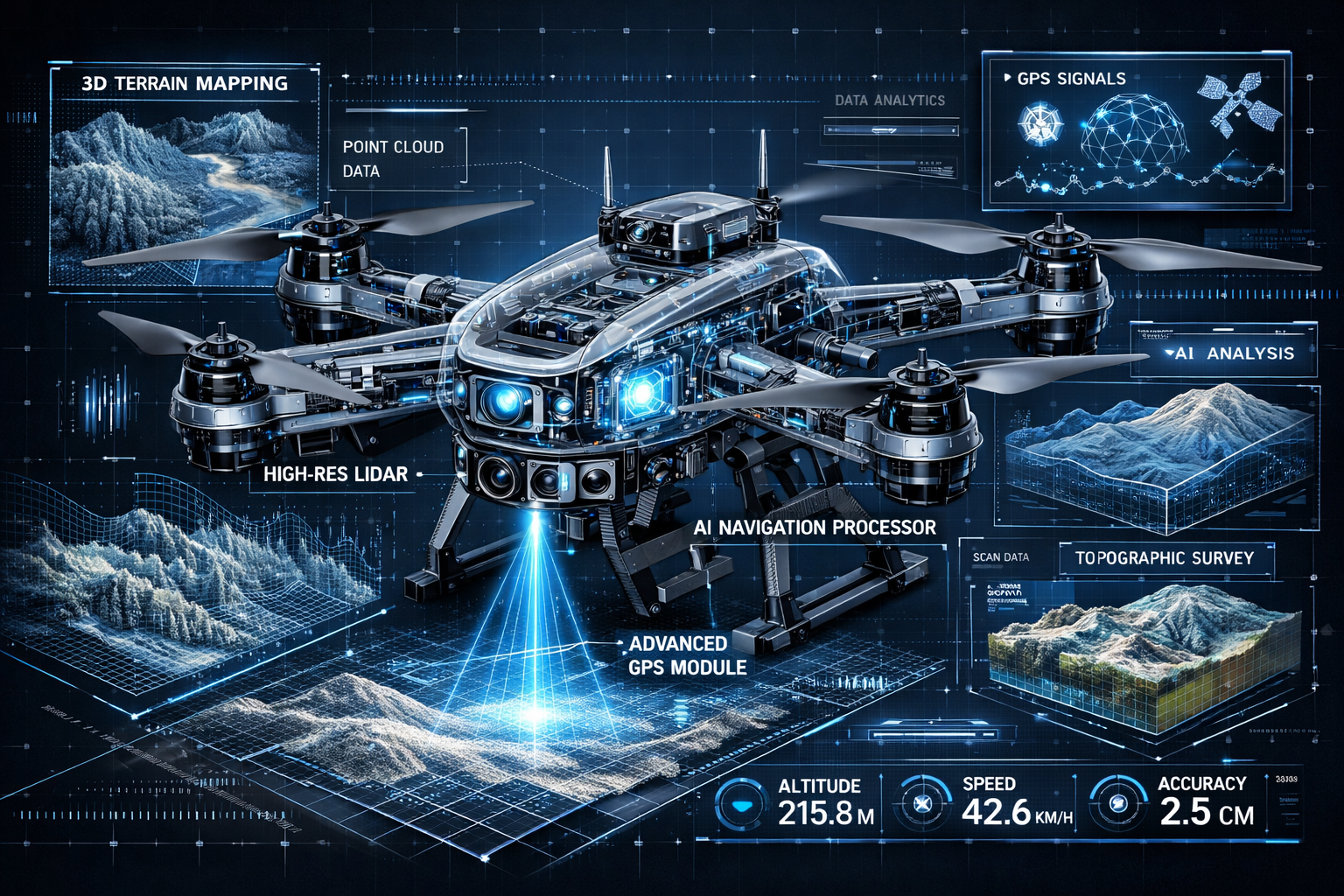
One of the most significant innovations in Drones in Land Surveying: UAV Innovations Reducing Costs and Boosting Accuracy in 2026 involves the integration of Light Detection and Ranging (LiDAR) sensors with UAV platforms. Unlike traditional photogrammetry, which relies on visible surfaces captured in photographs, LiDAR uses laser pulses to measure distances with extraordinary precision.
The technology works by emitting rapid laser pulses—often hundreds of thousands per second—and measuring the time it takes for each pulse to reflect back to the sensor. This creates dense point cloud data representing the three-dimensional structure of terrain and objects.
Key advantages of drone-based LiDAR:
🌲 Vegetation penetration: Laser pulses can penetrate gaps in forest canopy and dense vegetation to reach the ground surface below, enabling accurate terrain mapping even in heavily wooded areas[1]
📏 Centimeter-level accuracy: Modern LiDAR systems achieve vertical accuracy of 2-5 centimeters and horizontal accuracy of 5-10 centimeters, meeting or exceeding traditional survey standards
⚡ Rapid data collection: A single flight can capture millions of measurement points, creating comprehensive 3D models faster than ground-based methods[2]
🏗️ Multi-return capability: Advanced sensors detect multiple reflections from a single laser pulse, simultaneously mapping tree canopy, understory vegetation, and ground surface
The applications extend far beyond basic topographic mapping. Archaeologists use LiDAR to reveal hidden structures beneath jungle vegetation. Environmental scientists employ it for forest inventory and carbon storage estimation[1]. Infrastructure engineers rely on it for as-built documentation and change detection monitoring.
RTK and PPK Positioning: Achieving Survey-Grade Accuracy
Positional accuracy represents a critical challenge for any surveying method. Early drone surveys relied on consumer-grade GPS receivers with accuracy measured in meters—insufficient for professional surveying applications. The integration of Real-Time Kinematic (RTK) and Post-Processing Kinematic (PPK) positioning technology has transformed UAV surveys into survey-grade data collection platforms[2].
RTK positioning works by comparing GPS signals received by the drone with signals received by a stationary base station at a known location. This differential correction eliminates most GPS errors, achieving positional accuracy of 1-3 centimeters in real-time during flight.
PPK positioning applies similar correction principles but processes the data after flight completion rather than in real-time. This approach offers several advantages:
- No requirement for real-time communication between drone and base station
- More robust performance in areas with radio interference
- Ability to reprocess data with different parameters if needed
- Often superior accuracy compared to RTK in challenging conditions
The practical impact of RTK/PPK technology cannot be overstated. Projects that previously required extensive ground control point (GCP) networks—physical markers with precisely known coordinates placed throughout the survey area—now achieve comparable accuracy with minimal or no GCPs. This reduces fieldwork time, simplifies logistics, and accelerates project completion.
GPS-Denied Area Sensors: Expanding Operational Capabilities
A major breakthrough announced in 2025 and now widely deployed in 2026 involves sensors functioning in GNSS-denied areas—environments where traditional GPS signals are blocked or unavailable[3]. This innovation proves critical for:
- Tunnel inspections where satellite signals cannot penetrate
- Mine surveying in underground or covered operations
- Bridge underside inspections beneath concrete decks
- Building interiors and parking structures
- Urban canyon environments with signal multipath interference
These advanced sensors employ simultaneous localization and mapping (SLAM) technology, using visual and inertial sensors to track position and create maps without relying on external positioning signals. The technology enables comprehensive infrastructure inspections that previously required manual measurements from scaffolding or rope access—dangerous, time-consuming, and expensive approaches[3].
The safety implications alone justify adoption. Eliminating the need for inspectors to physically access confined spaces, work at height, or enter potentially unstable structures dramatically reduces workplace injuries while improving data quality and inspection thoroughness.
Sensor Fusion and Multispectral Capabilities
Modern survey drones function as flying sensor platforms capable of capturing diverse data types simultaneously. Sensor fusion technology integrates information from multiple sources—RGB cameras, thermal sensors, multispectral imagers, and LiDAR—into unified datasets that provide comprehensive site information[3].
Multispectral imaging captures light beyond the visible spectrum, revealing information invisible to the human eye:
- Near-infrared (NIR) bands detect vegetation health and moisture content
- Thermal sensors identify heat signatures for building envelope analysis or utility location
- Red-edge bands provide early detection of crop stress in agricultural applications
The integration of these diverse data streams creates powerful analytical capabilities. A single flight over a construction site might simultaneously produce:
- High-resolution visual documentation for progress monitoring
- Thermal imagery identifying insulation deficiencies or moisture intrusion
- Accurate 3D terrain models for earthwork volume calculations
- Vegetation health assessments for landscaping compliance
This multidimensional data collection proves particularly valuable for comprehensive condition survey reports, enabling surveyors to identify issues that might escape detection through visual inspection alone.
Automated Processing and AI Integration
Raw drone data—whether photogrammetric imagery or LiDAR point clouds—requires processing to create usable deliverables. Recent advances in automated processing workflows and artificial intelligence have dramatically reduced the time and expertise required for this critical step[2].
Modern photogrammetry software automatically:
- Identifies matching features across overlapping images
- Calculates camera positions and orientations
- Generates dense 3D point clouds
- Creates orthomosaic maps with uniform scale
- Produces digital elevation models and contour maps
AI-enhanced analysis takes this further by automatically extracting features from processed data. Machine learning algorithms can:
🏗️ Detect and classify objects (buildings, vehicles, vegetation, infrastructure)
📊 Extract slope data for landslide prediction and geological analysis[1]
📏 Measure stockpile volumes without manual delineation
🌳 Count individual trees and estimate biomass
🚧 Identify changes between survey dates for construction monitoring
These automated workflows minimize the post-processing burden that historically consumed significant time after data collection, allowing survey teams to focus on validation and analysis rather than manual data manipulation[3].
Practical Applications: How Industries Leverage Drone Surveying in 2026
Construction and Infrastructure Development
The construction industry represents one of the largest adopters of Drones in Land Surveying: UAV Innovations Reducing Costs and Boosting Accuracy in 2026. UAV technology supports projects throughout the entire construction lifecycle:
Pre-construction phase:
- Topographic surveys for site planning and design
- Environmental baseline documentation
- Access route evaluation
- Utility corridor mapping
Active construction:
- Progress monitoring with time-stamped visual documentation
- Earthwork volume calculations for cut-and-fill operations
- Quality control verification against design specifications
- Safety compliance monitoring
Post-construction:
- As-built documentation for facility management
- Final grading verification
- Punch list inspection support
The integration of drone data with Building Information Modeling (BIM) platforms creates powerful project management capabilities[2]. Regular drone surveys generate current site conditions that overlay with design models, instantly revealing discrepancies and enabling proactive problem-solving before issues escalate into costly rework.
For projects requiring detailed structural analysis, drone surveys complement traditional building survey approaches by providing comprehensive site context and exterior condition documentation.
Mining and Quarry Operations
Mining and aggregate operations demand frequent, accurate volume measurements for inventory management, production planning, and regulatory compliance. Traditional survey methods require surveyors to access active stockpiles and extraction areas—a time-consuming process that poses safety risks and interrupts operations.
Drone surveying transforms this workflow:
- Stockpile volume calculations complete in minutes rather than hours
- No operational disruption as flights occur over active areas without requiring equipment shutdown
- Historical tracking through regular surveys documenting extraction progress
- Safety improvements by eliminating surveyor exposure to unstable slopes and heavy equipment zones
The accuracy of drone-based volume calculations rivals or exceeds traditional methods. Studies consistently demonstrate agreement within 1-2% compared to ground-based measurements, well within acceptable tolerances for most applications.
Agriculture and Land Management
Agricultural applications leverage the multispectral capabilities of modern survey drones to optimize crop production and resource management:
🌾 Crop health monitoring: Multispectral imagery reveals vegetation stress before visible symptoms appear, enabling targeted intervention
💧 Irrigation assessment: Thermal and NIR data identify areas receiving inadequate or excessive water
🗺️ Precision agriculture mapping: Variable-rate application maps optimize fertilizer and pesticide use based on actual crop needs
📊 Yield prediction: Vegetation indices correlate with crop productivity, supporting harvest planning
Large agricultural operations conduct regular drone surveys throughout growing seasons, creating temporal datasets that reveal trends and inform management decisions. The cost-effectiveness of drone monitoring makes precision agriculture techniques accessible to operations that couldn't justify satellite imagery or manned aircraft surveys.
Environmental Monitoring and Conservation
Environmental scientists and conservation organizations employ drone surveying for ecosystem monitoring, habitat assessment, and environmental compliance verification:
- Wetland delineation with accurate boundary mapping for regulatory purposes
- Erosion monitoring through change detection between survey dates
- Wildlife habitat assessment documenting vegetation structure and composition
- Carbon storage estimation using LiDAR-derived forest structure measurements[1]
- Coastal monitoring tracking shoreline changes and dune migration
The ability to conduct non-invasive surveys without disturbing sensitive ecosystems represents a significant advantage over ground-based methods. Researchers access remote or fragile areas through aerial observation, collecting comprehensive data while minimizing environmental impact.
Urban Planning and Smart Cities
Municipal governments and urban planners utilize drone surveying for infrastructure management, planning applications, and public safety:
🏙️ 3D city modeling for visualization and analysis
🚧 Infrastructure condition assessment including roads, bridges, and public facilities
🌳 Urban tree inventory and canopy coverage analysis
📋 Property assessment support with accurate building measurements
⚡ Emergency response providing rapid situation assessment during disasters
The integration of drone data with GIS platforms enables dynamic, near real-time visualizations of municipal infrastructure and development projects[4]. Planners overlay topographic information, property boundaries, utilities, and zoning data to support informed decision-making and effective public communication.
For property professionals, drone surveys provide valuable context for various types of property surveys, from boundary verification to development feasibility assessment.
Regulatory Compliance and Best Practices for Survey Drone Operations
Understanding UK Drone Regulations in 2026
Operating survey drones legally and safely requires compliance with regulations established by the Civil Aviation Authority (CAA) and adherence to industry best practices. The regulatory framework balances innovation enablement with public safety and privacy protection.
Key regulatory requirements:
Operator registration: Organizations conducting commercial drone operations must register with the CAA and obtain an Operator ID. This registration demonstrates understanding of regulations and commitment to safe operations.
Pilot certification: Drone operators must hold appropriate qualifications based on operational category:
- A2 Certificate of Competency (A2 CofC) for operations near people
- General Visual Line of Sight Certificate (GVC) for standard commercial operations
- Operational authorizations for specific scenarios like beyond visual line of sight (BVLOS) or operations in controlled airspace
Drone registration: Individual aircraft must be registered and display registration numbers, enabling accountability and traceability.
Insurance requirements: Commercial operations require appropriate liability insurance, typically minimum £1 million coverage, though many surveyors carry significantly higher limits given project values.
Airspace restrictions: Operators must respect no-fly zones including:
- Airports and aerodromes (typically 5km exclusion zones)
- Restricted military areas
- Prisons and sensitive government facilities
- Temporary restrictions for events or emergencies
Modern flight planning software incorporates airspace data, automatically alerting operators to restrictions and simplifying compliance verification.
Pre-Flight Planning and Risk Assessment
Professional survey operations begin with thorough planning and risk assessment well before launching aircraft. Best practice workflows include:
Site reconnaissance: Physical or virtual site inspection to identify:
- Obstacles including power lines, towers, and structures
- Potential interference sources (radio transmitters, high-voltage lines)
- Access points and suitable launch/landing locations
- Ground control point placement opportunities
Mission planning: Defining flight parameters using specialized software:
- Flight altitude balancing safety, resolution requirements, and efficiency
- Image overlap percentages (typically 70-80% forward, 60-70% side overlap)
- Ground sample distance (GSD) appropriate for project accuracy requirements
- Battery management planning for larger sites requiring multiple flights
Risk assessment documentation: Formal evaluation of:
- Third-party risks (people, property, vehicles)
- Environmental hazards (weather, wildlife, terrain)
- Equipment failure scenarios and mitigation strategies
- Emergency procedures including lost link and forced landing protocols
Professional surveyors maintain comprehensive documentation demonstrating due diligence and regulatory compliance—essential for both legal protection and professional standards.
Flight Operations Best Practices
Safe, effective drone surveying requires disciplined operational procedures:
Pre-flight inspection: Systematic equipment check including:
- ✅ Battery charge levels and condition
- ✅ Propeller integrity and secure attachment
- ✅ Camera and sensor functionality
- ✅ GPS signal quality and satellite count
- ✅ Communication link verification
- ✅ Firmware and software currency
Weather monitoring: Continuous assessment of conditions including:
- Wind speed and gusts (most survey drones operate safely up to 10-15 m/s)
- Precipitation (moisture damages electronics and degrades image quality)
- Temperature (affects battery performance and flight time)
- Visibility (required for visual line of sight operations)
Crew coordination: Clear communication protocols when operating with multiple team members, including designated roles for pilot-in-command, visual observer, and ground control point placement.
Data management: Systematic file organization and backup procedures ensuring data integrity:
- Immediate backup of captured data to multiple storage devices
- Consistent file naming conventions linking data to specific projects and dates
- Metadata recording including flight parameters and environmental conditions
- Quality verification reviewing sample images before leaving the site
Post-Flight Data Processing and Quality Control
The processing phase transforms raw drone data into deliverable survey products. Quality control procedures ensure accuracy and reliability:
Ground control point integration: Incorporating precisely surveyed reference points to:
- Georeference photogrammetric models to real-world coordinates
- Verify and improve positional accuracy
- Enable comparison with existing survey data and CAD drawings
Processing parameter optimization: Adjusting software settings for:
- Point cloud density balancing detail and processing time
- Filtering algorithms removing noise and vegetation (for bare-earth models)
- Mesh generation parameters for 3D surface models
- Orthomosaic resolution and color balancing
Accuracy verification: Quantitative assessment of results through:
- Comparison with independent check points (not used in processing)
- Root mean square error (RMSE) calculation
- Visual inspection for artifacts, gaps, or anomalies
- Verification against existing survey data when available
Deliverable preparation: Creating final products meeting client specifications:
- Orthomosaic maps in standard formats (GeoTIFF, ECW)
- Digital elevation models (DEM) and digital surface models (DSM)
- Contour maps at specified intervals
- 3D models in various formats (OBJ, LAS, DXF)
- Volume calculations with cut-fill analysis
- Technical reports documenting methodology and accuracy
Surveyors familiar with comprehensive survey reporting recognize the importance of clear documentation supporting data quality and methodology transparency.
Data Security and Privacy Considerations
Survey operations frequently capture imagery of private property and potentially sensitive information. Professional practices include:
Data protection compliance: Adherence to UK GDPR requirements for personal data captured incidentally in survey imagery, including:
- Secure storage with encryption and access controls
- Retention policies limiting data storage duration
- Client confidentiality agreements
- Incident response procedures for data breaches
Privacy considerations: Respectful operations minimizing intrusion:
- Advance notification to affected property owners when practical
- Flight planning avoiding unnecessary overflight of residential areas
- Image blurring or redaction when required
- Transparent communication about data collection purposes
Intellectual property protection: Safeguarding proprietary survey data:
- Watermarking deliverables to prevent unauthorized use
- License agreements defining permitted uses
- Secure client data transfer protocols
- Archive management for professional liability protection
Selecting the Right Drone Platform and Sensors for Surveying Applications
Consumer vs. Professional Survey Drones
The drone market spans a broad spectrum from consumer photography drones to specialized survey-grade platforms. Understanding the distinctions guides appropriate equipment selection:
Consumer drones (£500-£2,000):
- ➖ Consumer-grade GPS (3-5 meter accuracy)
- ➖ Limited flight time (20-30 minutes)
- ➖ Basic cameras without calibrated lenses
- ➖ Minimal payload capacity for additional sensors
- ✅ Low initial investment
- ✅ Portable and easy to transport
Prosumer/Entry-level survey drones (£3,000-£10,000):
- ✅ RTK/PPK positioning capability
- ✅ Longer flight times (30-45 minutes)
- ✅ Higher resolution cameras with better lenses
- ✅ Improved wind resistance and stability
- ✅ Professional flight planning software integration
Professional survey-grade drones (£10,000-£50,000+):
- ✅ Survey-grade RTK/PPK systems
- ✅ Extended flight times (45+ minutes)
- ✅ Interchangeable sensor payloads
- ✅ LiDAR integration capability
- ✅ Redundant systems for enhanced safety
- ✅ Superior weather resistance
For surveyors establishing drone capabilities, entry-level professional platforms often provide the optimal balance of capability, accuracy, and cost-effectiveness. As operational experience grows and project demands increase, upgrading to more capable systems becomes justified by expanded service offerings and improved efficiency.
Fixed-Wing vs. Multirotor Platforms
Survey drones fall into two primary categories with distinct operational characteristics:
Multirotor drones (quadcopters, hexacopters, octocopters):
Advantages:
- Vertical takeoff and landing (no runway required)
- Hover capability for detailed inspections
- Superior low-altitude maneuverability
- Easier pilot training and operation
- Better suited for smaller project areas
Limitations:
- Shorter flight times (typically 25-45 minutes)
- Lower coverage efficiency for large areas
- Higher power consumption
- More affected by wind conditions
Fixed-wing drones:
Advantages:
- Extended flight times (60-120+ minutes)
- Greater coverage area per flight
- More efficient for large-scale mapping
- Better wind penetration
- Lower power consumption per area covered
Limitations:
- Require launch and landing space (catapult or runway)
- Cannot hover for detailed inspection
- More complex operation and training
- Higher initial cost for comparable systems
Project characteristics guide platform selection. Smaller sites under 100 acres with complex terrain or structures typically favor multirotor platforms. Large-area surveys covering hundreds or thousands of acres benefit from fixed-wing efficiency. Many established survey firms maintain both platform types, selecting the optimal tool for each project.
Essential Sensors and Payload Options
Modern survey drones function as modular platforms accepting various sensor payloads:
RGB cameras: High-resolution visible-light cameras for photogrammetry and visual documentation. Key specifications include:
- Sensor size (larger sensors improve low-light performance)
- Resolution (20+ megapixels common for survey work)
- Lens quality and calibration
- Mechanical or electronic shutter (mechanical preferred to eliminate rolling shutter distortion)
LiDAR sensors: Laser scanning systems for direct 3D measurement. Considerations include:
- Point measurement rate (100,000 to 500,000+ points per second)
- Accuracy specifications (vertical and horizontal)
- Maximum range and minimum altitude
- Number of returns captured per pulse
- Weight and power requirements
Multispectral cameras: Specialized sensors capturing specific wavelength bands beyond visible light, used for:
- Vegetation health assessment (NDVI and other indices)
- Crop stress detection
- Water quality monitoring
- Material identification
Thermal cameras: Infrared sensors detecting heat signatures for:
- Building envelope analysis
- Solar panel inspection
- Utility location
- Wildlife surveys
- Search and rescue operations
Budget-conscious surveyors typically begin with high-quality RGB cameras for photogrammetric surveying, adding specialized sensors as client demands and project opportunities justify the investment. The versatility of modern platforms enables sensor upgrades without replacing the entire aircraft system.
Future Trends: Where Drone Surveying Technology Heads Beyond 2026
Autonomous Operations and AI-Driven Analysis
The trajectory of Drones in Land Surveying: UAV Innovations Reducing Costs and Boosting Accuracy in 2026 points toward increasingly autonomous operations with minimal human intervention[2]. Emerging capabilities include:
Fully autonomous missions: Drones that independently:
- Assess site conditions and optimize flight parameters
- Adapt to changing weather and lighting conditions
- Detect and avoid obstacles in real-time
- Make intelligent decisions about data quality and coverage gaps
- Automatically recharge and resume interrupted missions
AI-powered analysis: Machine learning algorithms that:
- Automatically extract features and measurements from raw data
- Detect anomalies and potential issues requiring attention
- Generate comprehensive reports with minimal human review
- Provide predictive analytics based on temporal datasets
- Continuously improve accuracy through learning from corrections
These advances promise to further reduce the expertise barrier for drone surveying while improving consistency and reliability. Survey firms will shift focus from data collection mechanics toward interpretation, client consultation, and strategic planning.
Swarm Technology and Coordinated Multi-Drone Operations
Individual drone limitations—particularly flight time and coverage area—drive development of coordinated swarm operations where multiple drones work simultaneously on large projects. Benefits include:
- Dramatically reduced survey time for extensive areas
- Redundancy improving reliability and data completeness
- Specialized sensor deployment with different drones carrying complementary payloads
- Continuous operations with rotating drones while others recharge
While regulatory frameworks currently limit widespread swarm deployment, pilot programs demonstrate viability, and regulatory evolution will likely enable broader adoption within the next few years.
Integration with Digital Twin and Smart City Platforms
Survey data increasingly feeds into comprehensive digital twin systems—virtual replicas of physical infrastructure that enable simulation, analysis, and predictive maintenance[2]. Drones provide the continuous data streams required to keep digital twins current and accurate.
Smart city initiatives leverage drone surveys for:
- Infrastructure monitoring and maintenance planning
- Traffic flow analysis and optimization
- Environmental quality tracking
- Emergency response coordination
- Urban planning and development simulation
The convergence of drone surveying, IoT sensors, and advanced analytics creates unprecedented capabilities for understanding and managing complex built environments.
Enhanced Sensor Miniaturization and Capability
Ongoing sensor development delivers:
- Smaller, lighter LiDAR systems enabling deployment on smaller, more affordable platforms
- Higher resolution cameras capturing finer detail from greater altitudes
- Hyperspectral sensors moving beyond multispectral to hundreds of wavelength bands
- Quantum sensors potentially revolutionizing positioning accuracy and magnetic field detection
- Improved thermal resolution enabling more detailed temperature mapping
These advances expand drone surveying applications while reducing equipment costs, accelerating the technology's accessibility to smaller firms and specialized applications.
Conclusion: Embracing the Drone Revolution in Professional Surveying
The transformation represented by Drones in Land Surveying: UAV Innovations Reducing Costs and Boosting Accuracy in 2026 extends far beyond simple tool substitution. UAV technology fundamentally reimagines how surveyors approach projects, enabling capabilities that were impossible or impractical with traditional methods. The documented cost savings exceeding $80,000 annually[4], dramatic time reductions from weeks to hours[1], and accuracy improvements through LiDAR and RTK/PPK integration[2][3] create compelling economic and technical justification for adoption across the surveying profession.
For surveying professionals, the question has shifted from "Should we adopt drone technology?" to "How quickly can we integrate UAVs into our service offerings?" The technology has matured beyond experimental status to become an industry standard, with clients increasingly expecting drone-based deliverables as routine rather than premium services.
Actionable Next Steps for Surveying Professionals
For firms considering drone adoption:
- Assess your project portfolio: Identify which current and potential projects would benefit most from drone surveying capabilities—typically large-area topographic surveys, construction monitoring, and infrastructure inspection
- Invest in training and certification: Obtain proper CAA qualifications and develop operational competency through structured training programs before purchasing equipment
- Start with appropriate equipment: Select entry-level professional platforms with RTK/PPK capability rather than consumer drones, ensuring deliverables meet professional standards from the outset
- Develop processing workflows: Invest time learning photogrammetry and point cloud processing software, as data processing represents the critical link between raw imagery and deliverable products
- Build regulatory compliance systems: Establish documentation, risk assessment, and operational procedures ensuring consistent legal compliance and professional standards
For surveyors expanding existing drone capabilities:
- Upgrade positioning systems: If operating drones without RTK/PPK, prioritize this enhancement to achieve survey-grade accuracy and reduce ground control requirements
- Add specialized sensors: Expand service offerings through LiDAR, thermal, or multispectral sensors targeting specific market opportunities
- Integrate with existing workflows: Connect drone data with traditional survey methods, CAD systems, and GIS platforms for seamless project delivery
- Pursue advanced authorizations: Obtain operational approvals for beyond visual line of sight (BVLOS) or night operations where project demands justify expanded capabilities
- Develop expertise in emerging applications: Position your firm as an innovator by mastering applications like BIM integration, digital twin development, or automated change detection
For clients and project managers:
- Specify drone deliverables: Include UAV surveying in project specifications where appropriate, defining accuracy requirements, deliverable formats, and quality standards
- Verify operator qualifications: Ensure drone service providers hold proper certifications, insurance, and documented safety procedures
- Understand capability limitations: Recognize that drone surveying excels in certain applications while traditional methods remain superior for others—work with qualified professionals to determine optimal approaches
- Plan for data integration: Consider how drone deliverables will integrate with existing project data, CAD systems, and workflows during project planning phases
The future of land surveying clearly incorporates UAV technology as a fundamental capability rather than specialized niche. Professionals who embrace this transformation position themselves for success in an increasingly competitive and technology-driven industry. Those who resist risk obsolescence as clients migrate toward providers offering the efficiency, accuracy, and comprehensive data that only drone surveying delivers.
The innovations driving Drones in Land Surveying: UAV Innovations Reducing Costs and Boosting Accuracy in 2026 represent just the beginning of this technological revolution. As autonomous operations, AI-driven analysis, and sensor fusion continue advancing, the gap between early adopters and laggards will only widen. The time to act is now—whether through initial adoption, capability expansion, or strategic partnership with drone specialists. The surveying profession's future belongs to those who recognize that the sky is no longer the limit—it's the new frontier.
For surveyors seeking to understand how drone technology complements traditional approaches, exploring resources on different types of surveyors and what chartered surveyors do provides valuable context for integrating UAV capabilities within professional practice frameworks.
References
[1] Drone Surveying – https://uavcoach.com/drone-surveying/
[2] The Future Of Land Surveying Technology And Upcoming Trends In 2026 – https://metricop.com/blogs/land-surveying/the-future-of-land-surveying-technology-and-upcoming-trends-in-2026
[3] Next Generation Drone Sensors And The Future Of Surveying – https://www.commercialuavnews.com/next-generation-drone-sensors-and-the-future-of-surveying
[4] With Gis Technology Drone Industry Alights In Reality – https://www.esri.com/about/newsroom/arcnews/with-gis-technology-drone-industry-alights-in-reality
[5] Revolutionizing Land Surveying The Rise Of Drone Technology And Uav Applications In 2026 – https://nottinghillsurveyors.com/blog/revolutionizing-land-surveying-the-rise-of-drone-technology-and-uav-applications-in-2026