
The global land surveying market was valued at USD 5.5 billion in 2024 and is projected to reach USD 9.3 billion by 2033 — and a significant portion of that growth is being driven not by new instruments, but by the cloud infrastructure connecting them [3]. Static PDFs emailed between surveyors, clients, and solicitors are rapidly being replaced by live, browser-based environments where every stakeholder sees the same data at the same moment. That shift is what Cloud-Based Surveying Platforms: Enabling Real-Time Collaboration and Accessibility is all about in 2026.

Key Takeaways 📌
- Cloud-based surveying platforms move heavy processing — AI feature extraction, QA/QC, and 3D model rendering — off local machines and into the cloud, enabling field teams to use smartphones instead of expensive controllers.
- Real-time collaboration cuts project turnaround from weeks to days, with crews uploading data as it is collected and office staff reviewing it instantly.
- Subscription-based cloud services level the playing field, removing large upfront hardware and software costs for smaller firms.
- Browser-based 3D viewers allow clients, architects, and surveyors to annotate the same point cloud or survey report simultaneously — no specialist software required.
- Cloud platforms are now considered a career-resilience tool, with firms increasingly expecting staff proficiency in web-based portals for plan submission and revision tracking.
How Cloud-Based Surveying Platforms Are Replacing Static Workflows
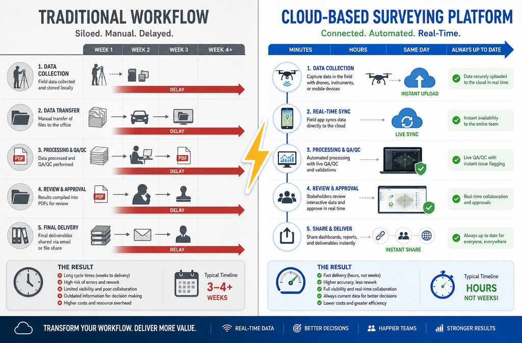
For decades, the standard surveying deliverable was a PDF — flat, uneditable, and frozen in time the moment it was exported. Once emailed, it became a liability: version confusion, missed annotations, and delayed sign-offs were routine. Cloud-Based Surveying Platforms: Enabling Real-Time Collaboration and Accessibility fundamentally disrupts this model.
From Static PDFs to Live, Browser-Based Environments
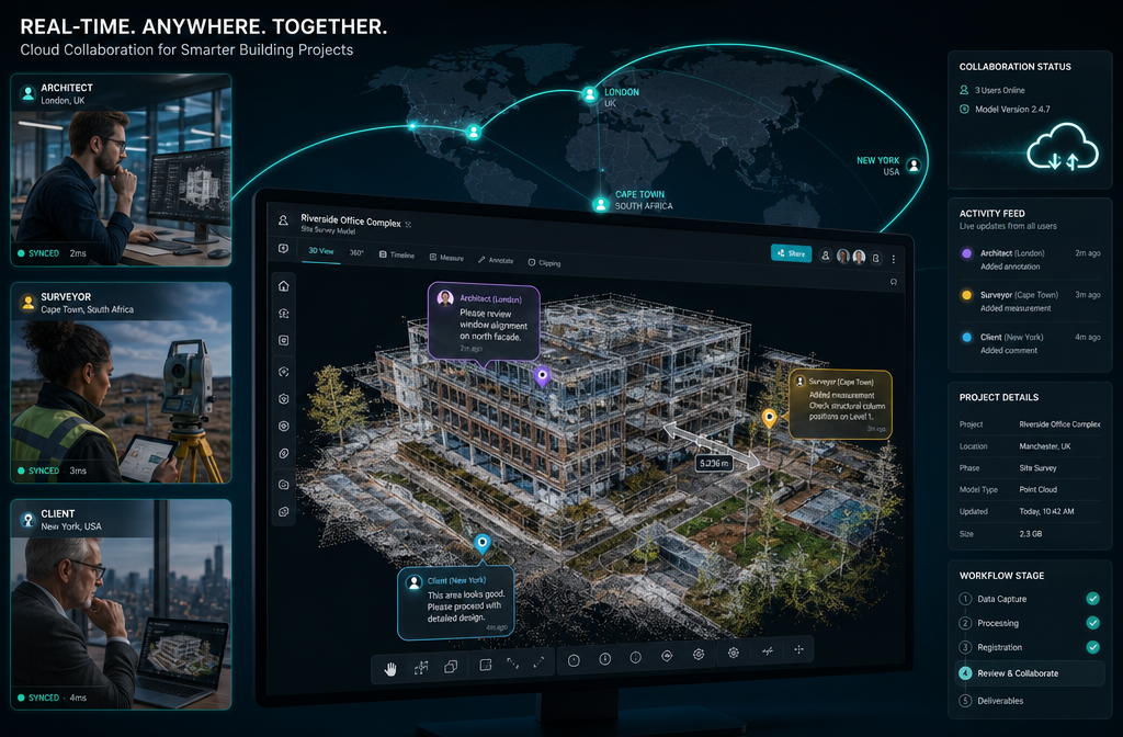
Modern cloud surveying platforms host data in centralised environments accessible through any standard web browser. Instead of downloading a 200 MB CAD file or waiting for a courier to deliver printed drawings, stakeholders — from the commissioning client to the structural engineer — open a shared link and interact with the same live dataset.
💬 "Reality-capture workflows now commonly push point clouds and images directly to cloud environments where teams, clients, and other stakeholders can access and annotate data within hours instead of days." — The American Surveyor [4]
Key features replacing the static PDF workflow include:
| Old Workflow | Cloud Platform Equivalent |
|---|---|
| Emailed PDF report | Live browser-based report with embedded 3D viewer |
| Printed redline markups | Real-time annotation tools with user-stamped comments |
| Version-numbered file names | Automatic revision history with timestamps |
| Phone calls to clarify findings | In-platform messaging tied to specific data points |
| Desktop CAD software required | Browser-only access — no installation needed |
This matters enormously for multi-stakeholder property projects. Consider a full structural survey on a complex commercial building: the surveyor, the buyer's solicitor, the lender's valuer, and the client may all need to review the same findings simultaneously. Cloud platforms make that possible without a single email attachment.
Instant Sharing and Revision Syncing in Practice
When a surveyor uploads field data — whether drone imagery, LiDAR point clouds, or condition ratings — the cloud platform processes and publishes it immediately. Office-based QA/QC staff can review and flag issues in real time, while the field crew is still on site and able to re-inspect if needed [1].
This closed-loop revision cycle is a major operational upgrade. Previously, a discrepancy found during office review meant scheduling a return visit days later. With cloud syncing, the correction can happen the same morning.
For property professionals using services like RICS commercial building surveys or stock condition surveys, this means faster, more accurate reports delivered to clients without the traditional back-and-forth delay.
The Technology Stack Powering Real-Time Collaboration
Understanding why cloud platforms work so well requires a brief look at the technology underneath them. Three converging forces make 2026 the tipping point for widespread adoption.
AI Processing in the Cloud
Historically, processing a LiDAR scan or drone photogrammetry dataset required a powerful workstation. That bottleneck is gone. Cloud-based surveying platforms now handle all heavy computation — AI feature extraction, automated linework generation, boundary detection, and topographic classification — in the cloud [1].
The practical result: a surveyor in the field can use a smartphone-based surveying app rather than a £15,000 field controller. The device captures the data; the cloud does the thinking. Open-source AI models integrated into these platforms automate common tasks in near real time, directly from the field [1].
This democratisation of processing power is significant. As McKissock Learning notes, drones, LiDAR, AI-enhanced mapping, and 3D point clouds are "quickly becoming the standard," and cloud platforms are what make these technologies practically usable at scale [2].
Browser-Based 3D Viewers: No Software Installation Required
One of the most client-facing innovations is the browser-based 3D viewer. Rather than sending a client a proprietary file format they cannot open, surveyors share a URL. The client clicks it and sees a fully navigable 3D model of their property — rotating it, zooming in, clicking on flagged defects, and reading the associated condition notes.
This is transforming how reports are delivered and consumed. MunsonED Survey's 2026 trends analysis highlights that cloud platforms now let firms "host large 3D models, share them with clients through browser-based viewers, and collaboratively mark up issues in real time without requiring specialized desktop software" [5].
For a homebuyer reviewing a Level 3 building survey, being able to visually navigate a 3D representation of the property and see exactly where a defect sits — rather than reading a text description and guessing — is a transformative improvement in transparency and understanding.
The Role of Digital Twins and 3D Deliverables
Digital twins — virtual replicas of physical assets that update as conditions change — are among the most significant outputs of cloud-connected surveying [5]. In 2026, wider adoption of digital twins is listed as one of the top surveying trends, directly enabled by cloud platforms that can host and serve large 3D models.
For commercial property owners, a digital twin means:
- 🏗️ Continuous condition monitoring without repeat physical inspections
- 📐 Accurate space planning using up-to-date measured survey data
- 🔍 Defect tracking over time with version-controlled 3D snapshots
- 🤝 Shared access for facilities managers, tenants, and insurers
Accessibility and the Democratisation of Surveying Technology
Cloud-Based Surveying Platforms: Enabling Real-Time Collaboration and Accessibility is not just a workflow story — it is an economic story. The shift to cloud fundamentally changes who can afford to participate in advanced surveying.
Levelling the Playing Field for Smaller Firms
Before cloud platforms, advanced surveying capabilities — LiDAR processing, photogrammetry, large-scale GIS — required significant capital investment in workstations, servers, and perpetual software licences. This created a two-tier market: large firms with the infrastructure, and smaller firms without it.
Cloud subscription models change this equation entirely. As The American Surveyor reports, reality capture has evolved from a specialist service to an "increasingly accessible toolset that surveying firms of all sizes can deploy," largely because subscription cloud services remove the need for major upfront investment [4].
MunsonED Survey's analysis reinforces this: smaller firms are "adapting without over-committing" by using consumption-based or tiered cloud subscriptions instead of buying perpetual software licences [5]. This shifts costs from capital expenditure (CapEx) to operating expenditure (OpEx), with the ability to scale storage and processing capacity up or down per project.
💬 "Firms increasingly expect staff to be proficient with web-based portals for plan submission, revision tracking, and client communication, as on-premise-only workflows are being phased out." — McKissock Learning [2]
Accessibility for Clients and Non-Technical Stakeholders
Cloud platforms do not just benefit surveying firms — they dramatically improve the experience for clients who are not technical specialists.
Consider the typical homebuyer. Receiving a Level 2 home survey as a 40-page PDF can be overwhelming. A cloud-delivered version of the same report — with interactive condition ratings, embedded photographs linked to floor plan locations, and the ability to ask questions directly within the platform — is far more accessible and actionable.
The same principle applies to larger projects. A housing association commissioning a stock condition survey across hundreds of properties benefits enormously from a cloud dashboard showing live progress, aggregated condition data, and filterable defect reports — all without needing to chase individual surveyors for updates.
Security, Compliance, and Data Governance
Accessibility must be balanced with security. Cloud platforms used in property surveying handle sensitive data — structural defects, valuations, boundary disputes — that requires careful governance.
Leading platforms address this through:
- 🔒 Role-based access controls — clients see their data; they cannot see other projects
- 📋 Audit trails — every view, comment, and download is logged
- 🌍 GDPR-compliant data residency — UK and EU data stored within appropriate jurisdictions
- 🔐 End-to-end encryption — data protected in transit and at rest
PwC's 2026 Digital Trends in Operations Survey confirms that across industries, cloud collaboration platforms are now core to operations, with executives reporting increased use of cloud to integrate field, office, and partner workflows [8]. The surveying sector is no exception.
Practical Implications for Property Professionals in 2026
The adoption of cloud-based surveying platforms has direct, practical consequences for everyone involved in property transactions and management.
For Surveyors and Surveying Firms
- Faster delivery: Turnaround times reduced from weeks to days for boundary and topographic jobs [1]
- Remote QA/QC: Senior surveyors can review and approve field data from any location
- Competitive differentiation: Firms offering live dashboards and browser-based reports stand out in a crowded market
- Career resilience: Proficiency in cloud platforms is now a hiring requirement at many firms [2]
Understanding what a chartered surveyor does in 2026 increasingly includes fluency with these digital collaboration tools alongside traditional technical skills.
For Property Buyers and Owners
- Greater transparency: See exactly what was inspected and when
- Easier comparison: Compare findings across multiple surveys in a single dashboard
- Faster decisions: No waiting for emailed PDFs; access reports the moment they are published
- Better communication: Ask questions directly within the platform, tied to specific findings
For anyone navigating the house survey checklist process, cloud-delivered reports make it significantly easier to track which items have been addressed and which remain outstanding.
For Developers and Asset Managers
Large-scale projects — residential developments, commercial refurbishments, portfolio condition assessments — involve dozens of stakeholders across months or years. Cloud platforms provide:
| Benefit | Impact |
|---|---|
| Single source of truth | Eliminates version conflicts across teams |
| Live progress tracking | Reduces management overhead |
| Integrated defect management | Links survey findings directly to maintenance schedules |
| Historical data retention | Supports long-term asset management decisions |
Challenges and Considerations
No technology shift is without friction. Firms and clients adopting cloud-based surveying platforms should be aware of:
- Connectivity dependency: Field teams in remote locations may face upload challenges without reliable mobile data
- Training investment: Staff accustomed to desktop workflows need time to adapt
- Platform fragmentation: Multiple competing platforms can create interoperability headaches
- Data lock-in risk: Proprietary formats may complicate switching platforms later
- Cost management: Consumption-based pricing requires careful monitoring on large LiDAR or UAV datasets [5]
These are manageable challenges, not blockers — but they require deliberate planning during platform selection and onboarding.
Conclusion: Actionable Next Steps for 2026
Cloud-Based Surveying Platforms: Enabling Real-Time Collaboration and Accessibility represent the most significant operational shift in the surveying profession in a generation. The convergence of AI processing, browser-based 3D viewers, real-time revision syncing, and subscription pricing has made advanced surveying capabilities accessible to firms and clients of every size.
The static PDF era is ending. What replaces it is faster, more transparent, more collaborative, and ultimately more valuable for every stakeholder in a property transaction or asset management programme.
Here are the actionable next steps to take right now:
- ✅ Audit your current workflow — identify every point where a PDF or email creates a delay or version risk
- ✅ Evaluate cloud platform options — prioritise browser-based access, GDPR compliance, and API integrations
- ✅ Upskill your team — invest in training on cloud collaboration tools as a core professional competency [2]
- ✅ Brief your clients — explain the benefits of live dashboards and interactive reports before the survey begins
- ✅ Start small, then scale — use a tiered subscription on one project type before committing to full platform migration [5]
- ✅ Choose RICS-regulated surveyors who are already equipped with cloud-native workflows for your next property survey
Whether commissioning a Level 2 vs Level 3 survey or managing a portfolio of commercial assets, the right cloud platform transforms a one-time report into an ongoing, collaborative asset — one that serves every stakeholder from the moment data is captured to the final sign-off and beyond.
References
[1] Revolutionizing Land Surveying How Ai And Machine Learning Are Predicting Risks And Automating Workflows In 2026 – https://www.canterburysurveyors.com/blog/revolutionizing-land-surveying-how-ai-and-machine-learning-are-predicting-risks-and-automating-workflows-in-2026/
[2] How To Stay Competitive In The Age Of Land Survey Automation – https://www.mckissock.com/blog/land-surveyor/how-to-stay-competitive-in-the-age-of-land-survey-automation/
[3] Land Surveying Market 2026 Deep Dive Trends Growth Aslve – https://www.linkedin.com/pulse/land-surveying-market-2026-deep-dive-trends-growth-aslve
[4] Doubling Down On Digital – https://amerisurv.com/2026/02/01/doubling-down-on-digital/
[5] 2026 Surveying Trends How Survey Firms Are Adapting Without Overcommitting – https://munsonedsurvey.com/blogs/news/2026-surveying-trends-how-survey-firms-are-adapting-without-overcommitting
[6] Web Based – https://www.getapp.com/customer-management-software/survey/os/web-based/?sort=relevance
[8] Digital Trends Operations Survey – https://www.pwc.com/us/en/services/consulting/supply-chain-operations/library/digital-trends-operations-survey.html