
The surveying profession stands at a pivotal crossroads in 2026. Static PDF deliverables and isolated data silos are rapidly becoming relics of the past, replaced by dynamic, cloud-based platforms that enable instant collaboration, browser-based 3D visualization, and real-time project synchronization. Client expectations have fundamentally shifted—no longer satisfied with traditional survey products delivered weeks after fieldwork, stakeholders now demand interactive access, immediate insights, and continuous collaboration throughout project lifecycles.[1] This transformation isn't merely technological; it represents a complete reimagining of how surveying professionals deliver value, interact with clients, and integrate spatial data into broader construction and design workflows.
Cloud-based surveying platforms: why real-time collaboration is becoming industry standard reflects the convergence of several powerful trends—from common data environments (CDEs) to AI-powered analytics, from reality capture integration to visualization-driven decision-making. The question facing surveying firms is no longer whether to adopt cloud collaboration, but how quickly they can transform their workflows to meet evolving industry expectations.
Key Takeaways
- 📊 Client expectations transformed: Static document deliverables are obsolete; clients now expect interactivity, instant access, and real-time collaboration through cloud platforms[1]
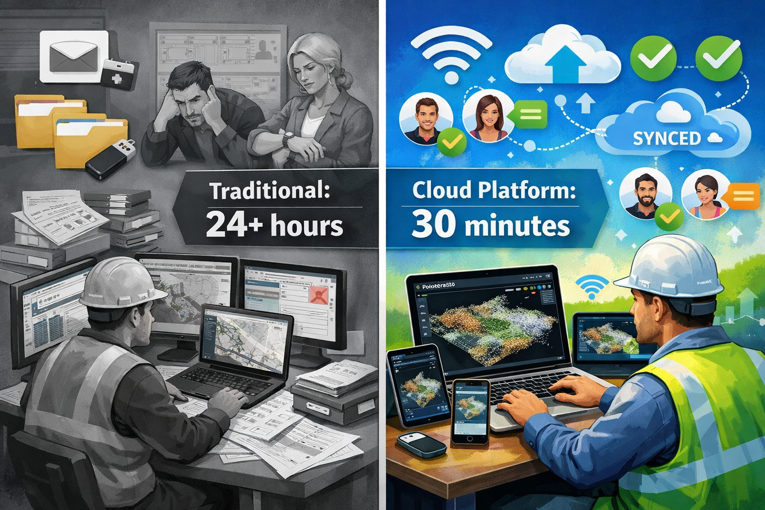
- ⚡ Dramatic efficiency gains: Cloud platforms reduce processing time from over 24 hours to as little as 30 minutes for complex survey workflows, using only laptops and standard WiFi[2]
- 🔄 Common Data Environments (CDEs) accelerating: Surveyors increasingly contribute to dynamic, shared environments where spatial data informs real-time decision-making across entire construction projects[3]
- 🎯 Visualization-driven workflows: Design conversations now occur directly within 3D models rather than traditional 2D plans, enabling faster iterations and stronger stakeholder alignment[3]
- 🤖 AI and automation integration: Cloud analytics layers enable automated classification, feature extraction, risk analysis, and predictive insights within unified data environments[2]
The Transformation from Static Deliverables to Dynamic Collaboration
Traditional Surveying Workflows: The Old Paradigm
For decades, surveying followed a predictable pattern: field crews collected data, office teams processed information through multiple standalone software applications, and clients received static deliverables—typically PDF reports, printed plans, or CAD files delivered via email or physical media. This workflow created several critical bottlenecks:
- Sequential processing delays: Data moved linearly from field collection through processing, quality assurance, and delivery, often requiring days or weeks
- Software silos: Point cloud processing, CAD drafting, photogrammetric analysis, and reporting each required separate applications with complex import/export procedures
- Limited client interaction: Stakeholders received finished products with minimal opportunity for real-time feedback or iterative refinement
- Version control challenges: Multiple file versions circulated via email, creating confusion about current status and approved revisions
- Accessibility barriers: Specialized software requirements prevented many stakeholders from directly viewing or interacting with survey data
Traditional workflows for processing a single square mile combining lidar and aerial imagery required multiple software products, numerous file transfers, and over a day of combined processing and quality assurance time.[2] This approach, while functional, couldn't support the accelerated project timelines and collaborative workflows that modern construction demands.
The Cloud Revolution: What Changed in 2026
The surveying industry's digital transformation accelerated dramatically in 2026, driven by several converging factors. Cloud-based platforms now provide instant file sharing, browser-based 3D visualization, real-time revision syncing, and integrated communication with engineers, architects, and project stakeholders—completely replacing traditional static deliverables.[1]
Consider the transformation demonstrated by platforms like Pointerra3D: processing the same 1-square-mile area that previously required a full day now takes just 30 minutes of manual time using a standard laptop and conference WiFi.[2] This isn't merely incremental improvement—it represents a fundamental restructuring of surveying workflows around cloud computing, unified platforms, and collaborative access.
"Client expectations fundamentally shifted in 2026. Static document deliverables are obsolete; clients now expect interactivity, collaboration, and instant access through cloud-based platforms."[1]
The transformation extends beyond speed. Cloud platforms consolidate previously fragmented workflows—point cloud calibration, classification, feature extraction, and photogrammetric processing—into single, unified environments that eliminate the need for multiple standalone tools and complex data handoffs.[2]
Key Capabilities Driving Adoption
Modern cloud-based surveying platforms deliver capabilities that were impossible with traditional workflows:
Instant Accessibility 🌐
- Browser-based access eliminates specialized software requirements
- Stakeholders view and interact with survey data from any device
- Mobile field teams access real-time project updates without returning to office
Real-Time Synchronization 🔄
- Changes propagate instantly across all project participants
- Version control happens automatically with complete revision history
- Conflicts and duplications eliminated through centralized data management
Interactive 3D Visualization 📐
- Point clouds, photogrammetry, and CAD models viewable directly in browsers
- Measurement tools, annotations, and markup capabilities accessible to all stakeholders
- Design conversations occur within actual 3D spatial context rather than abstract 2D representations
Integrated Communication 💬
- Comments, questions, and feedback attached directly to specific locations within survey data
- Notification systems alert relevant team members to changes or requests
- Decision documentation preserved within spatial context for future reference
For property professionals seeking comprehensive assessment capabilities, understanding how modern surveying integrates with traditional services like RICS home surveys provides valuable context for the industry's evolution.
Cloud-Based Surveying Platforms: Why Real-Time Collaboration Transforms Project Delivery
Common Data Environments: The Foundation of Modern Collaboration
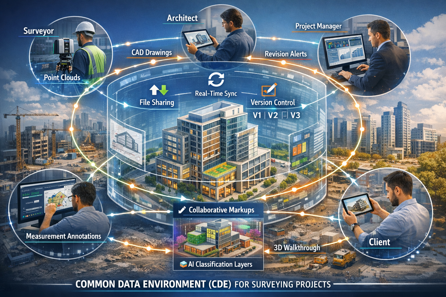
Rather than producing isolated static plans or point clouds, surveyors in 2026 increasingly contribute to Common Data Environments (CDEs)—dynamic, shared platforms where spatial data informs real-time decision-making across entire construction projects.[3] CDEs represent a fundamental shift in how project information flows throughout design, construction, and facility management phases.
What Makes CDEs Different:
| Traditional Approach | Common Data Environment |
|---|---|
| Isolated survey deliverables | Integrated spatial foundation |
| Sequential data handoffs | Simultaneous multi-stakeholder access |
| Static snapshots in time | Continuously updated living model |
| Discipline-specific formats | Unified, interoperable data structure |
| Limited revision tracking | Complete version history and audit trails |
| Email-based file distribution | Centralized, permission-based access |
CDEs enable surveyors to position their work as the foundational spatial layer upon which all other project disciplines build. Architects reference survey data directly when developing designs, engineers analyze structural considerations within accurate as-built context, and project managers track construction progress against baseline survey conditions—all within the same collaborative environment.
This integration dramatically reduces errors caused by outdated information, misaligned coordinate systems, or misinterpreted deliverables. When all stakeholders work from the same spatial truth, coordination improves, conflicts decrease, and project timelines compress.[3]
Visualization-Driven Workflows: From Plans to Models
One of the most significant trends identified by surveying technology experts for 2026 is the shift toward visualization-driven workflows.[3] Design conversations increasingly occur directly within 3D models rather than traditional 2D plans, enabling quicker iterations, faster workflows, and stronger alignment throughout design and construction phases.
Spatial data now serves as the foundation for centralized discussions where designers and stakeholders provide context, resolve questions, and make decisions in real-time.[3] This transformation affects how surveyors present information, structure deliverables, and interact with clients.
Key Aspects of Visualization-Driven Collaboration:
- Contextual understanding: Stakeholders grasp spatial relationships, site conditions, and design implications more quickly through 3D visualization than traditional plans
- Faster decision-making: Questions answered immediately by rotating, measuring, and analyzing within shared 3D environment
- Reduced misinterpretation: Visual clarity eliminates ambiguity that often plagues text descriptions or 2D representations
- Enhanced stakeholder engagement: Non-technical participants contribute meaningfully when viewing intuitive 3D representations
- Iterative refinement: Design alternatives evaluated rapidly by overlaying options within actual site context
For professionals conducting detailed property assessments, the principles of visualization-driven collaboration complement traditional approaches like Level 2 home surveys by providing richer contextual information for decision-making.
Reality Capture as Core Service Offering
Reality capture is emerging as a standard project management workflow rather than a specialized service.[3] Surveyors can now document existing conditions, visually track construction progress, and collaborate in real-time, enhanced by AI, machine learning, and cloud-based platforms.
Surveying firms integrating reality capture into their core offerings differentiate themselves significantly, as clients increasingly expect rich digital deliverables beyond traditional survey products.[3] This expectation shift creates both opportunity and pressure—firms must invest in new capabilities while adapting business models to deliver ongoing value rather than one-time products.
Reality Capture Applications in Cloud Environments:
📸 Progress Documentation
- Periodic site scans uploaded to cloud platforms
- Automated comparison against project schedules and design models
- Visual progress reports accessible to all stakeholders instantly
🏗️ As-Built Verification
- Construction accuracy validated against design intent in real-time
- Deviations identified and addressed before subsequent work proceeds
- Quality assurance documentation preserved within spatial context
🔍 Condition Assessment
- Detailed documentation of existing structures for renovation projects
- Change detection highlighting deterioration or modifications over time
- Digital twins supporting ongoing facility management and maintenance
The integration of reality capture with cloud collaboration platforms enables capabilities impossible with traditional workflows. For instance, drone surveys can now feed directly into cloud environments where multiple stakeholders analyze results simultaneously, dramatically compressing decision timelines.
Interoperability: Breaking Down Data Silos
Construction technology vendors, including major players like Trimble, are accelerating efforts to enhance workflow integrations and data compatibility across diverse software ecosystems.[3] This interoperability focus enables seamless survey data integration regardless of clients' existing technology stacks.
Why Interoperability Matters:
The construction industry uses an incredibly diverse technology landscape—different CAD platforms, BIM software, project management tools, and specialized analysis applications. For cloud-based surveying platforms to become truly collaborative, they must exchange data fluidly with these varied systems.
Improved interoperability creates two significant effects:
- Expanded market opportunity: Surveyors can serve clients using any technology platform, increasing potential client base
- Elevated expectations: Clients expect survey data formatted and structured for immediate use in their specific workflows[3]
This dynamic requires surveying firms to understand not just their own software and processes, but also how their deliverables integrate into broader project ecosystems. Cloud platforms that handle format conversions, coordinate system transformations, and data structure adaptations automatically provide significant competitive advantages.
For professionals working across property types, understanding how different survey approaches like Level 2 versus Level 3 surveys integrate with modern cloud collaboration tools helps optimize service delivery.
Technical Capabilities Enabling Real-Time Collaboration
Unified Platform Architectures: Consolidating the Toolchain
One of the most significant technical advances enabling cloud-based surveying collaboration is the emergence of unified platform architectures that consolidate previously fragmented workflows. Traditional surveying required multiple specialized software applications—one for point cloud processing, another for photogrammetry, separate tools for CAD drafting, feature extraction, and reporting.
Pointerra3D exemplifies this consolidation approach, providing a single-platform solution that eliminates point cloud calibration, classification, feature extraction, and photogrammetric processing silos.[2] This architecture removes the need for complex exports, imports, and file conversions that previously drained time and computing resources.
Benefits of Unified Platforms:
✅ Reduced technical barriers: Team members access all capabilities through single interface
✅ Eliminated data handoff errors: Information flows seamlessly between processing stages
✅ Simplified training: Staff learn one comprehensive system rather than multiple specialized tools
✅ Consistent data quality: Automated workflows apply standardized processing parameters
✅ Accelerated processing: Integrated pipelines eliminate redundant data transformations
The dramatic efficiency gains are measurable. Processing workflows that previously required high-powered workstations and over 24 hours now complete in 30 minutes using standard laptops and conference WiFi.[2] This democratization of processing power means field teams can generate preliminary results on-site, enabling immediate client collaboration and decision-making.
AI and Machine Learning Integration
Cloud platforms increasingly incorporate AI and machine learning capabilities that automate time-consuming classification, feature extraction, and analysis tasks.[2][3] These intelligent systems learn from vast datasets, continuously improving accuracy and expanding capabilities.
AI-Powered Capabilities in Cloud Surveying Platforms:
🤖 Automated Classification
- Point clouds automatically segmented into ground, vegetation, buildings, infrastructure
- Machine learning models trained on millions of examples achieve human-level accuracy
- Manual classification time reduced from hours to minutes
🎯 Intelligent Feature Extraction
- Building footprints, road centerlines, utility poles automatically identified
- Dimensional attributes (height, width, volume) calculated automatically
- Extraction accuracy improves continuously as AI models learn from corrections
📊 Predictive Analytics
- Risk analysis identifying potential issues before they manifest
- Maintenance predictions based on condition trends over time
- Resource optimization recommendations for project planning
⚡ Automated Quality Control
- Anomalies, outliers, and errors flagged automatically during processing
- Completeness verification ensuring no data gaps in deliverables
- Accuracy validation against control points and overlap areas
The integration of AI capabilities within cloud platforms means these sophisticated analyses are accessible to all project stakeholders without requiring specialized expertise. An architect can query a point cloud for all windows above a certain height, an engineer can extract all structural columns within a specific area, and a project manager can measure progress against schedule—all through intuitive interfaces powered by underlying AI.
For property professionals conducting specialized assessments like comprehensive condition survey reports, AI-enhanced analysis tools provide deeper insights while reducing manual processing time.
Scalable Computing and Flexible Pricing Models
Cloud platforms enable scalable computing resources that adapt to project demands without requiring capital investment in hardware. This flexibility fundamentally changes the economics of surveying, particularly for smaller firms and variable workloads.
Processing Unit Bundle Model:
Platforms like Pointerra3D introduced tiered Processing Unit (PU) bundle models—mirroring successful approaches from AWS and Google Cloud—that provide predictable, scalable billing.[2]
| Bundle Tier | Processing Units | Ideal For |
|---|---|---|
| Explorer | 50 PUs | Small projects, testing workflows |
| Adopter | 100 PUs | Regular project volume, growing firms |
| Pro | 500 PUs | Large projects, high-volume operations |
Advantages of PU-Based Pricing:
💰 Predictable budgeting: Firms purchase bundles matching anticipated workload
📈 Scalability: Additional capacity available instantly when needed
📊 Transparent tracking: Real-time dashboards show usage and remaining capacity
🔄 Flexible allocation: Resources distributed across multiple projects as priorities shift
This model eliminates the traditional dilemma of either investing in expensive hardware that sits idle between projects or limiting project acceptance based on processing capacity. Cloud platforms provide enterprise-grade computing power on-demand, leveling the competitive playing field between large and small firms.
Browser-Based Visualization and Collaboration Tools
Perhaps the most visible aspect of cloud-based surveying platforms is browser-based visualization that eliminates specialized software requirements. Stakeholders access, view, and interact with complex 3D survey data using standard web browsers on any device—desktop computers, tablets, or smartphones.
Core Browser-Based Capabilities:
🖥️ 3D Point Cloud Viewing
- Smooth navigation through millions or billions of points
- Color modes (RGB, intensity, classification, elevation)
- Measurement tools for distances, areas, volumes, angles
📐 Integrated CAD and BIM Models
- Design overlays compared against survey data
- Clash detection identifying conflicts between design and existing conditions
- Transparency controls for layered visualization
✏️ Collaborative Markup and Annotation
- Comments, questions, and feedback attached to specific 3D locations
- Drawing tools for highlighting areas of interest
- Photo attachments linking issues to visual documentation
🔔 Real-Time Notifications
- Alerts when relevant changes occur or comments require response
- Customizable notification preferences by project role
- Activity feeds tracking all project interactions
📱 Cross-Device Synchronization
- Work started on desktop continues seamlessly on tablet or phone
- Consistent interface across all devices
- Offline capabilities for field use with sync upon reconnection
These capabilities transform how surveying firms interact with clients. Rather than scheduling formal presentation meetings to review static deliverables, collaboration occurs continuously as stakeholders explore data at their convenience, ask questions asynchronously, and receive immediate responses.
Understanding how modern collaborative tools complement traditional services helps professionals deliver comprehensive solutions—for example, integrating cloud-based visualization with detailed Level 3 building surveys provides both technical rigor and accessible client communication.
Industry Impact and Adoption Drivers
Hybrid Work Models Accelerating Cloud Adoption
The widespread adoption of hybrid work models—combining remote and in-office collaboration—has accelerated cloud platform adoption across all industries, including surveying.[5] Teams distributed across multiple locations require tools that enable seamless collaboration regardless of physical location.
Cloud-based surveying platforms provide essential capabilities for hybrid teams:
Virtual Collaboration Features:
- Digital whiteboards: Brainstorming and problem-solving sessions conducted within shared visual workspace
- Integrated communication: Chat, video calls, and screen sharing connected directly to project data
- Real-time editing: Multiple team members work simultaneously on same datasets without conflicts
- Asynchronous feedback: Stakeholders in different time zones contribute at convenient times with all input preserved
These capabilities maintain team cohesion and agile decision-making even when members work from different offices, home locations, or field sites.[5] For surveying firms, this flexibility enables access to specialized expertise regardless of geographic location, improves work-life balance for staff, and reduces overhead costs associated with centralized office space.
Competitive Differentiation and Client Expectations
As cloud-based collaboration becomes standard in 2026, surveying firms face a clear competitive dynamic: clients increasingly expect interactive, collaborative deliverables as baseline service.[1] Firms still delivering static PDFs and CAD files via email risk appearing outdated and losing projects to competitors offering modern cloud-based workflows.
Differentiation Opportunities:
🌟 Enhanced client experience: Interactive exploration of survey data creates stronger engagement and satisfaction
⚡ Faster project delivery: Compressed processing and review timelines accelerate overall project schedules
🎯 Reduced errors and rework: Real-time collaboration catches issues early when corrections are least expensive
📈 Expanded service offerings: Cloud platforms enable ongoing monitoring, change detection, and facility management services
💡 Value-based pricing: Rich interactive deliverables justify premium pricing over commodity survey products
Conversely, firms that fail to adopt cloud collaboration face significant risks:
⚠️ Perceived as outdated: Clients question whether firms using old delivery methods employ current field techniques
📉 Limited to price competition: Commodity deliverables compete primarily on cost rather than value
🚫 Excluded from complex projects: Large projects increasingly require cloud collaboration as contractual requirement
⏰ Slower response times: Traditional workflows can't match the agility clients expect in 2026
For property professionals, understanding how cloud collaboration complements specialized services like commercial building surveys helps position comprehensive, modern service offerings.
Digital Twin Creation and Long-Term Asset Management
Cloud platforms enable surveying firms to expand beyond one-time project delivery into ongoing asset management and digital twin services. Digital twins—virtual replicas of physical assets continuously updated with real-world data—represent significant long-term revenue opportunities for forward-thinking firms.
Digital Twin Capabilities Enabled by Cloud Platforms:
🏢 Baseline Documentation
- Initial comprehensive survey establishes accurate as-built foundation
- All building systems, infrastructure, and site features captured in detail
- Spatial accuracy enables precise future change detection
🔄 Continuous Monitoring
- Periodic resurveys identify changes, deterioration, or modifications
- Automated comparison highlights differences since previous capture
- Trend analysis predicts future maintenance requirements
📊 Integrated Analytics
- Sensor data (temperature, humidity, structural movement) linked to spatial model
- Performance metrics tracked against physical locations
- Energy efficiency, space utilization, and operational patterns analyzed
🛠️ Maintenance Optimization
- Work orders linked to specific locations within digital twin
- Maintenance history preserved with spatial context
- Predictive analytics identify issues before failures occur
This shift from project-based to relationship-based business models provides recurring revenue, deeper client relationships, and higher barriers to competition. Clients investing in digital twin platforms are unlikely to switch providers, as accumulated historical data represents significant value.
Environmental Intelligence and Risk Analysis
Cloud analytics layers now enable automated risk analysis and environmental intelligence that extends surveying's value proposition beyond traditional measurement and documentation.[2] These capabilities position surveyors as strategic advisors rather than tactical service providers.
Advanced Analytics Applications:
🌊 Flood Risk Assessment
- Topographic analysis identifies areas vulnerable to flooding
- Historical change detection tracks erosion or deposition patterns
- Climate scenario modeling predicts future risk under various conditions
🏗️ Construction Site Safety
- Automated detection of hazardous conditions (unstable slopes, overhead obstacles)
- Clearance verification for equipment and material deliveries
- Progress monitoring ensuring work proceeds according to safety plans
🌳 Environmental Compliance
- Vegetation mapping and change detection for environmental impact assessment
- Wetland delineation and monitoring for regulatory compliance
- Habitat tracking supporting conservation requirements
⚡ Infrastructure Condition Assessment
- Automated identification of pavement distress, structural damage, or deterioration
- Comparative analysis tracking condition changes over time
- Prioritization algorithms optimizing maintenance investment
These sophisticated analyses, previously requiring specialized expertise and significant manual effort, are now automated within cloud platforms and accessible to all stakeholders.[2] This democratization of advanced analytics creates opportunities for surveying firms to deliver higher-value insights while differentiating from competitors offering only basic measurement services.
Implementation Strategies and Best Practices
Evaluating Cloud Platform Options
Surveying firms considering cloud platform adoption face numerous options with varying capabilities, pricing models, and integration approaches. Systematic evaluation ensures selection of platforms aligned with specific business needs and client requirements.
Key Evaluation Criteria:
📋 Functional Capabilities
- Point cloud processing, photogrammetry, CAD integration, BIM compatibility
- AI-powered classification and feature extraction
- Measurement tools, annotation capabilities, reporting features
- Mobile app availability and offline functionality
🔗 Integration and Interoperability
- Compatibility with existing software ecosystem (CAD, BIM, project management)
- API availability for custom integrations and workflow automation
- Data import/export formats and coordinate system support
- Third-party application marketplace or plugin ecosystem
💰 Pricing and Economics
- Subscription models (per-user, per-project, processing-unit-based)
- Storage costs and data retention policies
- Scalability and flexibility for variable workloads
- Total cost of ownership including training and support
👥 User Experience
- Interface intuitiveness for both technical staff and non-technical stakeholders
- Learning curve and training requirements
- Mobile and browser performance across devices
- Accessibility features for diverse user needs
🔒 Security and Compliance
- Data encryption (in transit and at rest)
- Access controls, authentication, and permission management
- Compliance certifications (ISO, SOC 2, industry-specific standards)
- Data sovereignty and geographic storage options
📞 Vendor Stability and Support
- Company financial stability and market position
- Customer support responsiveness and expertise
- User community size and engagement
- Product roadmap and development velocity
Firms should conduct pilot projects testing platforms with real project data before committing to enterprise-wide adoption. This approach identifies workflow friction points, training needs, and integration challenges in controlled environments.
Change Management and Team Training
Technology adoption succeeds or fails based on people and processes as much as technical capabilities. Cloud platform implementation requires thoughtful change management addressing both practical skills and cultural adaptation.
Effective Training Strategies:
📚 Tiered Learning Approach
- Basic users: Browser-based viewing, navigation, measurement, and annotation
- Power users: Data upload, processing, classification, and quality control
- Administrators: User management, permissions, integration configuration, and reporting
🎯 Role-Specific Training
- Field crews: Mobile data capture, preliminary processing, and client collaboration on-site
- Office staff: Advanced processing, feature extraction, deliverable preparation, and quality assurance
- Project managers: Client collaboration, progress tracking, and stakeholder communication
- Leadership: Analytics, reporting, business development, and strategic positioning
🔄 Continuous Learning
- Regular updates as platforms add new features
- Peer learning sessions sharing best practices and workflow innovations
- Vendor-provided webinars and certification programs
- External training resources and user communities
Cultural Adaptation:
Beyond technical skills, cloud collaboration requires cultural shifts in how teams work:
- Transparency: Real-time visibility into work-in-progress replaces sequential handoffs
- Collaboration: Individual ownership transitions to shared responsibility
- Continuous improvement: Feedback loops enable rapid iteration rather than single final delivery
- Client partnership: Ongoing dialogue replaces formal presentation milestones
Leadership must model these behaviors, celebrate collaborative successes, and address resistance constructively. Change champions within teams—early adopters enthusiastic about new approaches—accelerate adoption by supporting peers and demonstrating benefits.
Data Management and Quality Assurance
Cloud platforms introduce new considerations for data management, quality assurance, and long-term preservation. Establishing clear protocols ensures consistent quality and protects valuable project information.
Data Management Best Practices:
📁 Naming Conventions and Organization
- Standardized project, file, and dataset naming schemes
- Consistent folder structures across all projects
- Metadata standards capturing project details, processing parameters, and quality metrics
- Version control protocols for iterative deliverables
✅ Quality Control Workflows
- Automated checks for data completeness, accuracy, and consistency
- Manual review checkpoints at critical processing stages
- Peer review processes for complex or high-stakes projects
- Client acceptance procedures with documented approvals
💾 Backup and Archiving
- Redundant storage across multiple geographic locations
- Long-term archival strategies for completed projects
- Data retention policies aligned with legal and contractual requirements
- Migration plans for platform transitions or technology obsolescence
🔐 Security Protocols
- Role-based access controls limiting data visibility to authorized personnel
- Audit trails tracking all data access, modifications, and downloads
- Secure sharing mechanisms for external stakeholder collaboration
- Incident response procedures for potential security breaches
Quality Assurance in Collaborative Environments:
Real-time collaboration introduces quality assurance challenges—multiple users accessing and potentially modifying data simultaneously requires robust controls preventing errors while maintaining workflow fluidity.
Effective approaches include:
- Permission hierarchies: View-only access for most stakeholders, editing rights for qualified staff
- Change tracking: Complete audit trails documenting all modifications with user attribution
- Review gates: Formal approval required before advancing processing stages or releasing deliverables
- Automated validation: System checks preventing common errors (coordinate system mismatches, scale errors, incomplete classification)
Client Onboarding and Communication
Successfully delivering cloud-based collaborative services requires effective client onboarding that establishes clear expectations, provides necessary training, and demonstrates value quickly.
Client Onboarding Process:
🎯 Initial Orientation
- Platform overview demonstrating key capabilities
- Account setup and access credential distribution
- Security and confidentiality protocols review
- Communication preferences and notification settings
📖 Basic Training
- Navigation and viewing fundamentals
- Measurement and annotation tools
- Commenting and collaboration features
- Mobile app usage for field access
🚀 Quick Wins
- Early deliverables demonstrating platform value
- Specific use cases relevant to client's immediate needs
- Success metrics showing time savings or improved outcomes
- Comparison with previous project experiences using traditional deliverables
📞 Ongoing Support
- Dedicated contact for questions and technical assistance
- Regular check-ins during initial projects
- Advanced training as client needs evolve
- Feedback collection for service improvement
Communication Strategies:
Effective cloud collaboration requires proactive communication establishing rhythms and expectations:
- Project kickoff: Establish collaboration protocols, key milestones, and decision points
- Regular updates: Scheduled touchpoints reviewing progress and addressing questions
- Milestone notifications: Alerts when significant processing stages complete or deliverables ready for review
- Responsive engagement: Quick responses to client questions and feedback within platform
- Project closeout: Formal review of outcomes, lessons learned, and future opportunities
For firms offering specialized services like drainage surveys or boundary surveys, integrating cloud collaboration enhances traditional deliverables with interactive visualization and ongoing access.
Future Outlook: Where Cloud Collaboration is Heading
Emerging Technologies and Integration Trends
Cloud-based surveying platforms will continue evolving rapidly, incorporating emerging technologies that further enhance collaboration, automation, and value delivery.
Technology Trends Shaping the Future:
🤖 Advanced AI and Automation
- Natural language interfaces enabling stakeholders to query data conversationally
- Automated report generation tailored to specific stakeholder needs
- Predictive modeling anticipating project challenges before they occur
- Generative design suggesting optimal solutions based on survey constraints
🥽 Extended Reality (XR) Integration
- Virtual reality (VR) immersion in survey data for enhanced spatial understanding
- Augmented reality (AR) overlaying design models on physical sites via mobile devices
- Mixed reality (MR) collaboration enabling distributed teams to interact within shared 3D environments
- Haptic feedback providing tactile dimension to virtual data exploration
🛰️ Real-Time Data Streaming
- Continuous sensor networks feeding live data into cloud platforms
- Automated alerts when conditions exceed specified thresholds
- Dynamic digital twins updating continuously rather than periodic resurveys
- Integration with IoT devices for comprehensive environmental monitoring
🔗 Blockchain and Distributed Ledgers
- Immutable audit trails for regulatory compliance and dispute resolution
- Smart contracts automating payment upon verified milestone completion
- Decentralized data ownership enabling multi-party collaboration without central authority
- Provenance tracking ensuring data integrity throughout project lifecycle
Industry Standardization and Regulatory Evolution
As cloud collaboration becomes ubiquitous, industry standards and regulatory frameworks will evolve to address new capabilities and challenges.
Standardization Initiatives:
- Data formats: Universal standards for point cloud, photogrammetry, and BIM data exchange
- Metadata schemas: Consistent documentation of processing parameters, accuracy, and quality metrics
- Interoperability protocols: APIs and integration standards ensuring platform compatibility
- Quality benchmarks: Industry-wide quality standards for cloud-delivered survey products
Regulatory Considerations:
- Professional liability: Clarification of responsibility when multiple parties collaborate on shared data
- Data ownership: Legal frameworks defining rights to survey data in collaborative environments
- Privacy and security: Regulations governing sensitive project information in cloud platforms
- Archival requirements: Standards for long-term preservation of digital survey records
Professional organizations like RICS (Royal Institution of Chartered Surveyors) will play crucial roles establishing best practices, ethical guidelines, and competency standards for cloud-based surveying collaboration.
Business Model Evolution
Cloud platforms enable new business models that create recurring revenue, deeper client relationships, and higher-value service offerings.
Emerging Business Models:
💼 Subscription Services
- Ongoing monitoring and change detection rather than one-time surveys
- Regular updates maintaining current digital twin accuracy
- Continuous analytics providing insights over time
- Predictable revenue supporting business stability and growth
🤝 Partnership Ecosystems
- Collaboration with complementary service providers (engineering, architecture, construction)
- Integrated service bundles addressing complete project needs
- Revenue sharing arrangements for multi-party deliverables
- Platform-enabled marketplaces connecting clients with specialized expertise
📊 Data-as-a-Service
- Licensing historical survey data for analytics and research
- Aggregated insights across multiple projects informing industry benchmarks
- Anonymized datasets supporting AI model training and algorithm development
- Spatial intelligence products serving adjacent markets
🎯 Outcome-Based Pricing
- Fees tied to project success metrics rather than time and materials
- Performance guarantees enabled by real-time monitoring and rapid response
- Risk-sharing arrangements aligning surveyor and client interests
- Value-based pricing reflecting business impact rather than deliverable production cost
These evolving models position surveying firms as strategic partners rather than commodity service providers, creating sustainable competitive advantages and stronger client loyalty.
Conclusion: Embracing the Collaborative Future
Cloud-based surveying platforms: why real-time collaboration is becoming industry standard is not merely a technological trend—it represents a fundamental transformation in how surveying professionals create value, interact with clients, and contribute to successful project outcomes. The shift from static deliverables to dynamic, interactive collaboration platforms reflects broader changes in client expectations, project delivery methods, and the competitive landscape.
The evidence is compelling: processing times reduced from days to minutes, stakeholder engagement transformed from periodic reviews to continuous collaboration, and service offerings expanded from one-time deliverables to ongoing partnerships. Firms embracing these capabilities position themselves for sustainable success, while those clinging to traditional approaches risk obsolescence in an increasingly digital industry.
Key Success Factors
Surveying firms successfully navigating this transformation share common characteristics:
✅ Strategic technology investment: Thoughtful platform selection aligned with business objectives and client needs
✅ Comprehensive team training: Skill development addressing both technical capabilities and collaborative workflows
✅ Client-centric approach: Onboarding processes ensuring stakeholders realize platform value quickly
✅ Quality-focused processes: Robust data management and quality assurance maintaining professional standards
✅ Continuous adaptation: Ongoing learning and improvement as technologies and expectations evolve
Actionable Next Steps
For surveying professionals ready to embrace cloud-based collaboration, consider these practical steps:
Immediate Actions (This Month):
- Evaluate current workflows: Document existing processes, identifying bottlenecks and collaboration pain points
- Research platform options: Explore leading cloud surveying platforms, requesting demonstrations and trial access
- Assess team readiness: Survey staff regarding technology comfort, training needs, and change management concerns
- Engage key clients: Discuss collaboration expectations and gather feedback on current deliverable formats
Short-Term Initiatives (Next Quarter):
- Pilot project implementation: Select appropriate project for cloud platform trial, establishing success metrics
- Develop training program: Create role-specific training addressing both technical skills and collaborative practices
- Establish data protocols: Define naming conventions, quality standards, and security procedures for cloud environments
- Create client onboarding process: Develop materials and procedures for introducing clients to collaborative workflows
Long-Term Strategies (This Year):
- Full platform deployment: Transition primary workflows to cloud-based collaboration following successful pilots
- Service offering expansion: Develop new services leveraging cloud capabilities (digital twins, ongoing monitoring, predictive analytics)
- Business model innovation: Explore subscription, partnership, and outcome-based pricing approaches
- Industry engagement: Participate in professional organizations developing standards and best practices for cloud collaboration
The Competitive Imperative
In 2026, cloud-based real-time collaboration has transitioned from competitive advantage to competitive necessity. Clients increasingly expect interactive access, immediate insights, and continuous engagement as baseline service standards.[1] Surveying firms that view this transformation as optional risk finding themselves excluded from significant opportunities and relegated to commodity price competition.
Conversely, firms that embrace cloud collaboration position themselves as forward-thinking partners delivering exceptional value through modern, efficient workflows. The technology exists, proven implementations demonstrate dramatic benefits, and client demand continues accelerating. The question is not whether to adopt cloud-based collaboration, but how quickly your firm can successfully implement these transformative capabilities.
The future of surveying is collaborative, cloud-based, and client-centric. Firms that recognize and act on this reality will thrive in the evolving industry landscape, while those that resist will struggle to remain relevant. The choice—and the opportunity—is clear.
For surveying professionals seeking to understand how modern cloud collaboration integrates with traditional services across residential and commercial applications, exploring comprehensive resources on property surveys provides valuable context for positioning cloud-enabled services within broader professional offerings.
References
[1] Future Land Surveying 2026 – https://haller-blanchard.com/future-land-surveying-2026/
[2] Transforming The Future Of Survey Mapping – https://www.geoweeknews.com/news/transforming-the-future-of-survey-mapping
[3] Doubling Down On Digital – https://amerisurv.com/2026/02/01/doubling-down-on-digital/
[4] Cloud Collaboration Platform – https://www.aecplustech.com/tools/category/cloud-collaboration-platform
[5] Best Cloud Collaboration Tools – https://thedigitalprojectmanager.com/tools/best-cloud-collaboration-tools/
[6] 3dsurvey Is The Best Photogrammetry Software In 2026 – https://3dsurvey.si/3dsurvey-is-the-best-photogrammetry-software-in-2026/
[7] Best Remote Team Collaboration Software 2026 Complete Guide To Virtual Office Solutions – https://www.sowork.com/blog/best-remote-team-collaboration-software-2026-complete-guide-to-virtual-office-solutions
[8] Remote Collaboration Tools – https://www.achievers.com/blog/remote-collaboration-tools/