
The land surveying profession stands at a technological crossroads in 2026. For centuries, surveyors relied on meticulous manual measurements, careful calculations, and painstaking data analysis. Today, AI-Driven Precision in Land Surveying: How Artificial Intelligence is Transforming Data Collection and Analysis represents more than just an incremental improvement—it marks a fundamental shift in how professionals capture, process, and deliver geospatial information. Artificial intelligence now automates tasks that once consumed days or weeks, identifies patterns invisible to the human eye, and predicts future developments with remarkable accuracy. This transformation is making surveys faster, more accurate, and more valuable than ever before.
The integration of machine learning algorithms into surveying workflows has created unprecedented opportunities for efficiency and precision. Where surveyors once spent countless hours manually processing data points and drafting maps, AI systems now complete these tasks in minutes while maintaining higher accuracy standards. This technological revolution affects every aspect of the profession, from initial data collection through drone systems to final deliverable creation via cloud-based platforms.
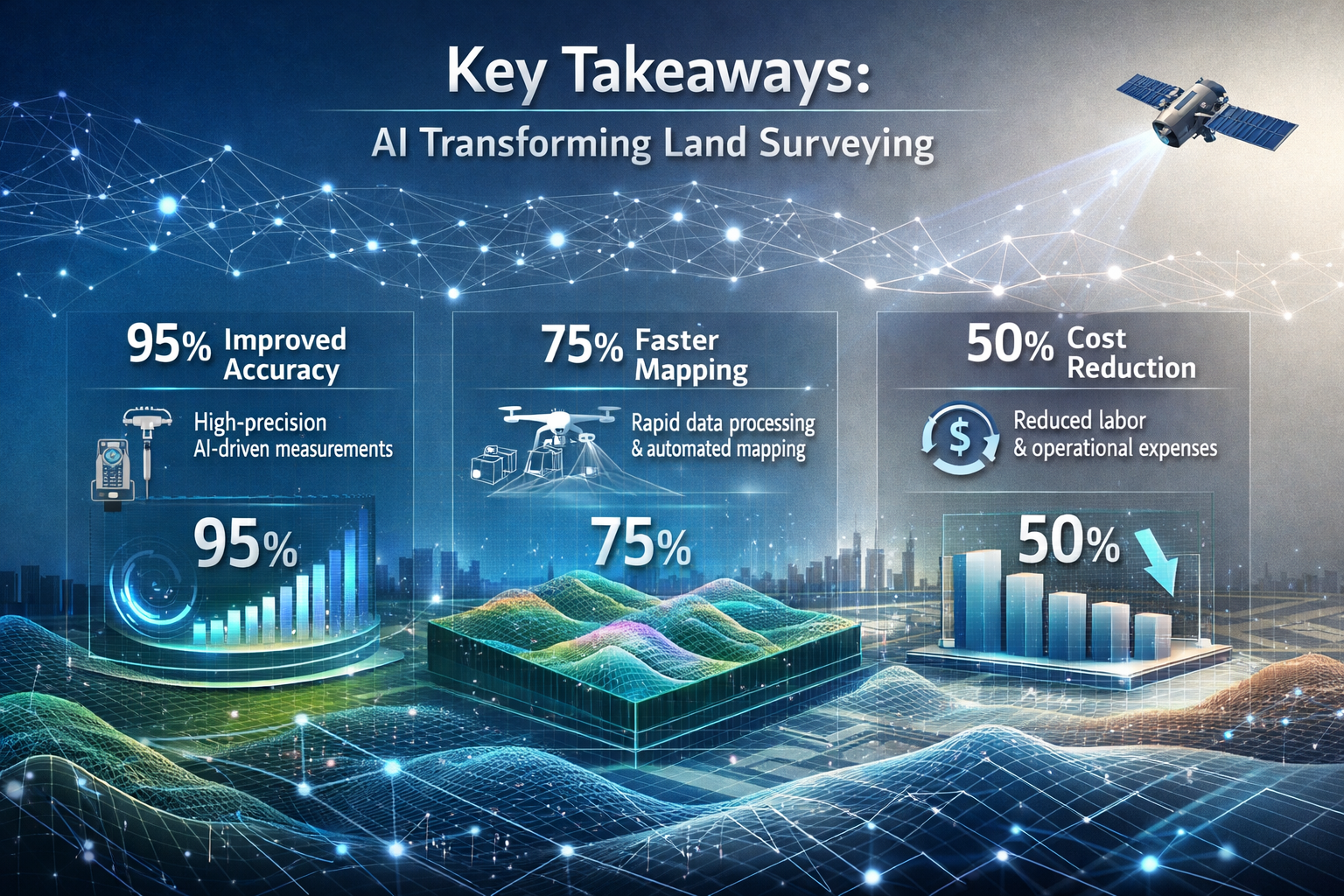
Key Takeaways
✅ AI systems now embed directly into core surveying workflows, instantly classifying terrain, identifying markers, flagging anomalies, and generating preliminary surface models without manual intervention[1]
✅ Autonomous drone swarms with multi-sensor arrays capture comprehensive LiDAR, photogrammetry, multispectral, and thermal data in single flights, achieving centimeter-level GPS precision[1][2]
✅ Machine learning algorithms detect patterns humans cannot see, including vegetation indicators of underground water sources and subtle terrain changes that signal potential issues[4]
✅ Real-time 3D digital twins have become standard deliverables, offering interactive models that simulate slope erosion, water flow, vegetation changes, and infrastructure stress testing[1]
✅ Cloud-based platforms enable instant collaboration, allowing clients, engineers, and architects to access surveying data through browser-based visualization tools with real-time revision syncing[1]
The Evolution of AI in Land Surveying Workflows
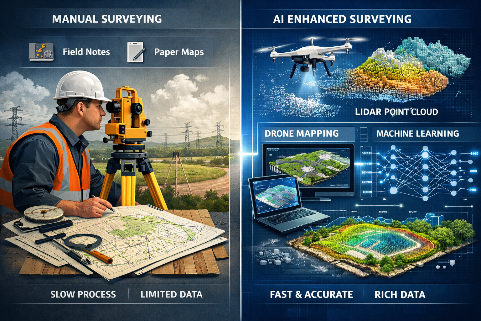
From Manual Processing to Automated Intelligence
The surveying industry has undergone a remarkable transformation over the past decade. Traditional workflows required surveyors to manually process thousands of data points, cross-reference measurements, identify potential errors, and create maps through labor-intensive drafting processes. In 2026, AI-Driven Precision in Land Surveying: How Artificial Intelligence is Transforming Data Collection and Analysis has fundamentally changed this paradigm.
AI is now embedded directly into core surveying workflows[1]. Rather than treating data processing as a separate post-collection phase, modern surveying systems integrate artificial intelligence at every stage. These AI systems perform critical functions automatically:
- 🎯 Instant terrain classification based on elevation data, surface characteristics, and contextual information
- 📍 Automatic survey marker identification using computer vision algorithms trained on thousands of reference images
- ⚠️ Real-time anomaly detection that flags inconsistencies, measurement errors, or unexpected variations
- 🗺️ Preliminary surface model generation that creates initial 3D representations without human drafting
This integration represents a fundamental shift from AI as a supplementary tool to AI as a core component of professional surveying practice. The technology doesn't replace surveyor expertise—instead, it amplifies professional judgment by handling routine tasks and highlighting areas requiring human attention.
AI-Assisted Quality Control and Review
Quality assurance has always been paramount in surveying, where even minor errors can have significant legal and financial consequences. Traditional quality control relied entirely on experienced professionals meticulously reviewing data sets, cross-checking measurements, and verifying calculations. While this approach remains essential, AI-assisted quality checks are being integrated into review pipelines[1].
These intelligent systems provide additional safeguards beyond traditional meticulous standards. AI quality control algorithms:
- Compare new survey data against historical records to identify unexpected variations
- Cross-reference measurements from multiple sensors to detect inconsistencies
- Apply statistical analysis to identify outliers that may indicate equipment malfunction or measurement errors
- Alert surveyors to potential issues before projects reach the drafting stage[1]
The result is a multi-layered quality assurance approach that combines AI efficiency with human expertise. Surveyors receive automated alerts about potential problems early in the process, allowing them to address issues while still on-site rather than discovering them during office review. This proactive approach saves time, reduces costs, and improves overall accuracy.
For professionals conducting RICS home surveys or homebuyer surveys, these AI-assisted quality controls ensure that property assessments meet the highest standards of accuracy and reliability.
Machine Learning Algorithms Revolutionizing Pattern Recognition
Detecting the Invisible: AI Pattern Analysis
One of the most powerful applications of artificial intelligence in surveying involves pattern recognition capabilities that exceed human perception. Machine learning algorithms analyze aerial imagery and geospatial data to identify features and patterns difficult for humans to detect[4]. This capability has opened entirely new possibilities for surveyors and their clients.
Consider the challenge of locating underground water sources—a task traditionally requiring expensive exploratory drilling or reliance on geological surveys. Modern AI systems can recognize vegetation patterns indicative of underground water sources[4], analyzing subtle variations in plant health, distribution, and seasonal changes that correlate with subsurface water presence. This application proves particularly valuable for:
- 💧 Agricultural land assessment and irrigation planning
- 🏗️ Construction site evaluation for foundation design
- 🌳 Environmental impact studies and watershed management
- 📊 Property valuation for land with water rights
The same pattern recognition capabilities extend to numerous other surveying applications. AI algorithms can identify:
- Subtle elevation changes that indicate soil erosion, subsidence, or geological instability
- Vegetation stress patterns that reveal drainage problems or contamination
- Historical land use indicators visible in aerial imagery but imperceptible to casual observation
- Infrastructure deterioration through thermal imaging analysis and structural pattern recognition
These capabilities transform surveyors from data collectors into strategic advisors who can provide insights about land characteristics that were previously impossible to detect without extensive testing.
Predictive Modeling and Future Development Forecasting
Beyond identifying current conditions, AI systems are increasingly capable of predicting future developments based on historical data patterns and current trends. Machine learning models trained on years of geospatial data can forecast:
🔮 Erosion progression based on soil type, slope angle, vegetation cover, and weather patterns
🔮 Vegetation growth patterns that will affect sight lines, property boundaries, or construction access
🔮 Drainage pattern evolution as land use changes or climate conditions shift
🔮 Infrastructure stress points where utilities or structures may experience future problems
This predictive capability adds tremendous value for clients making long-term investment decisions. A commercial developer can assess how a site will evolve over decades, not just its current state. Environmental consultants can model the long-term impact of proposed changes. Property owners can anticipate maintenance needs before problems become critical.
For those interested in understanding what surveyors check during property assessments, our guide on what does a surveyor check provides comprehensive insights into the inspection process.
Automated Mapping and Data Analysis: Speed Meets Accuracy
The End of Manual Drafting
Perhaps the most immediately visible impact of AI-Driven Precision in Land Surveying: How Artificial Intelligence is Transforming Data Collection and Analysis appears in the mapping and drafting phase. Traditional surveying required skilled technicians to manually create maps from raw data—a process that could take days or weeks for complex sites.
Automated mapping through AI is reducing manual drafting and data analysis time[4] by orders of magnitude. Modern AI systems can generate detailed maps and plans automatically using data from aerial images and other sources[4], transforming what was once the most time-consuming aspect of surveying into an automated process that completes in minutes.
These automated mapping systems:
- 📐 Extract features automatically from point cloud data, identifying buildings, roads, vegetation, water features, and terrain characteristics
- 🎨 Apply appropriate symbology and styling based on industry standards and client preferences
- 📏 Calculate areas, volumes, and distances with precision exceeding manual measurement
- 🔄 Update maps in real-time as new data becomes available or site conditions change
The time savings are substantial. A survey that once required 40 hours of manual drafting might now need only 2-3 hours of professional review and refinement. This efficiency doesn't just reduce costs—it enables surveyors to deliver results faster, allowing clients to make time-sensitive decisions without delay.
Intelligent Data Interpretation and Reporting
Beyond simple map creation, AI systems now provide intelligent data interpretation that adds context and meaning to raw measurements. Modern surveying software analyzes collected data to:
✨ Identify compliance issues with zoning regulations, setback requirements, or building codes
✨ Highlight potential problems such as drainage concerns, access limitations, or boundary disputes
✨ Generate narrative reports that explain technical findings in accessible language
✨ Create comparative analyses showing how current conditions differ from previous surveys or planned specifications
This intelligent interpretation bridges the gap between technical surveying data and practical decision-making. Clients receive not just measurements and maps, but actionable insights that inform their projects.
For those conducting boundary surveys or dealing with party wall disputes, AI-powered analysis can quickly identify discrepancies and potential conflict areas that require attention.
Autonomous Drone Technology and Multi-Sensor Integration
The Rise of Intelligent Aerial Systems
Drone technology has transformed land surveying over the past decade, but 2026 marks a new era of truly autonomous capabilities with predictive modeling[1]. Modern unmanned aerial vehicles (UAVs) represent far more than remote-controlled cameras—they're sophisticated AI-powered platforms that make intelligent decisions during data collection.
Multi-sensor drone systems now capture comprehensive data in single flights[1]. Rather than requiring separate missions for different data types, contemporary UAV systems carry synchronized sensor arrays that simultaneously collect:
- 🛰️ LiDAR (Light Detection and Ranging) for precise elevation mapping and 3D point clouds
- 📷 Photogrammetry cameras capturing high-resolution overlapping images for detailed visual documentation
- 🌿 Multispectral sensors measuring light wavelengths beyond human vision to assess vegetation health and soil conditions
- 🌡️ Thermal imaging units detecting temperature variations that indicate moisture problems, insulation gaps, or structural issues
This multi-sensor approach eliminates the need for multiple site visits[1], dramatically reducing project timelines and costs. A comprehensive site survey that once required three or four separate drone flights can now be completed in a single mission lasting 20-30 minutes.
Predictive Flight Planning and Adaptive Data Collection
The intelligence embedded in modern drone systems extends beyond sensor integration to include predictive modeling for flight path planning[1]. AI algorithms analyze site characteristics, weather conditions, and project requirements to automatically:
- 🎯 Optimize flight paths for maximum coverage with minimum flight time
- 📊 Adjust altitude dynamically based on terrain elevation and required resolution
- 🔄 Modify camera angles to ensure proper overlap for photogrammetry processing
- ⚙️ Select appropriate sensors for different portions of the survey area
These systems can even automatically adjust during flight to achieve optimal readings[1], responding to changing light conditions, unexpected obstacles, or areas requiring additional detail. The result is higher-quality data collected more efficiently than manual flight planning could achieve.
Drone Swarms and Coordinated Surveying
An emerging capability in 2026 involves autonomous drones working as swarms with minimal human intervention[2]. Rather than deploying a single UAV for large-scale projects, surveyors can now coordinate multiple drones that:
- 🤖 Execute precise, coordinated flight paths with automated collision avoidance
- ⚡ Increase speed and accuracy by dividing survey areas among multiple units
- 🌍 Cover large areas with fewer resources, completing in hours what once took days
- ⛰️ Access hard-to-reach areas that would be dangerous or impossible for human surveyors[2]
This swarm technology proves particularly valuable for large-scale projects such as highway corridors, utility right-of-way surveys, agricultural land assessment, and environmental monitoring across extensive wilderness areas[2].
For professionals offering drone surveys, these advanced capabilities represent a significant competitive advantage and enable services that were previously impractical or prohibitively expensive.
Centimeter-Level Precision: GPS and Positioning Technology
Real-Time Kinematic GPS Revolution
Positioning accuracy has always been fundamental to surveying quality. In 2026, centimeter-level GPS precision is now standard in commercial surveying[2], representing a quantum leap from the meter-level accuracy that characterized consumer GPS systems just a decade ago.
Real-time kinematic (RTK) GPS systems can achieve precision down to the centimeter in clear sky conditions[2]. This remarkable accuracy results from sophisticated signal processing that:
- 📡 Corrects atmospheric interference that degrades standard GPS signals
- 🎯 Triangulates from multiple satellite constellations (GPS, GLONASS, Galileo, BeiDou)
- ⏱️ Processes carrier phase measurements rather than just signal timing
- 🔧 Applies real-time corrections from fixed reference stations
The technology employs fixed base station receivers and roving units to correct weather-related discrepancies[2]. A stationary base station at a known location continuously calculates positioning errors caused by atmospheric conditions, satellite geometry, and other factors. It then broadcasts these corrections to mobile surveying units in real-time, enabling them to achieve centimeter-level accuracy even under challenging conditions.
Practical Applications of Ultra-Precise Positioning
This level of precision enables applications that were previously impractical or impossible:
✅ Construction layout with millimeter-level accuracy for complex building projects
✅ As-built verification confirming that constructed elements match design specifications
✅ Deformation monitoring detecting subtle structural movements that indicate settling or instability
✅ Precision agriculture enabling automated equipment to follow exact paths for planting and harvesting
✅ Infrastructure inspection documenting the precise location of defects or maintenance needs
For surveyors conducting commercial building surveys or monitoring surveys, this positioning accuracy provides documentation that meets the most stringent professional standards and legal requirements.
Real-Time 3D Digital Twins and Interactive Deliverables
Beyond Static Maps: Living Digital Models
Perhaps the most transformative change in surveying deliverables involves the shift from static documents to dynamic, interactive models. Real-time 3D digital twins are becoming standard deliverables for commercial clients[1] in 2026, fundamentally changing how surveying information is consumed and utilized.
A digital twin represents far more than a 3D visualization. These high-fidelity, interactive models update continuously as new data is collected[1], creating a living representation of the surveyed property that evolves over time. Clients can:
- 🔍 Explore the site virtually from any angle or elevation
- 📊 Query specific features to access detailed measurements and attributes
- 🕐 View historical changes by comparing snapshots from different time periods
- 🔗 Integrate additional data layers such as utility locations, soil conditions, or environmental factors
Simulation and Predictive Modeling Capabilities
The true power of digital twins emerges in their simulation capabilities. These models allow visualization of how land behaves under various conditions[1], enabling clients to test scenarios before committing to expensive decisions. Common simulations include:
🌊 Slope erosion projections showing how terrain will change over time under different weather patterns and vegetation management approaches
💧 Water flow simulations demonstrating drainage patterns during various rainfall intensities and identifying potential flooding or erosion problems
🌱 Vegetation pattern changes modeling how plant growth will affect sight lines, property boundaries, or environmental conditions
🏗️ Infrastructure stress testing analyzing how proposed structures will interact with terrain and existing improvements
These simulation capabilities transform surveying from a documentation service into a strategic planning tool. Developers can test multiple site plan variations virtually before breaking ground. Environmental consultants can model the impact of proposed changes. Property owners can visualize how improvements will look and function before investing in construction.
Cloud-Based Collaboration and Accessibility
The delivery mechanism for these advanced digital twins reflects another major shift in surveying practice. Cloud-based platforms are transforming how surveying deliverables are accessed and shared[1]. Rather than receiving static PDF documents or CAD files that require specialized software, clients in 2026 expect:
☁️ Instant file sharing through secure cloud platforms accessible from any device
🌐 3D browser visualization that requires no special software installation
🔄 Real-time revision syncing ensuring all stakeholders always access the current version
💬 Integrated communication with engineers, architects, and other professionals directly within the platform[1]
This cloud-based approach facilitates collaboration across distributed teams and enables faster decision-making. An architect in London can review survey data simultaneously with an engineer in Manchester and a client in Edinburgh, all viewing the same interactive 3D model and discussing specific features in real-time.
For those seeking to understand modern surveying approaches, our complete guide to home surveying explains how technology is improving the property assessment process.
Reality Capture Technology: Democratization and Integration
Accessible Reality Capture in 2026
Reality capture technology is becoming more democratized and user-friendly in 2026[5], expanding beyond specialized surveying applications to become accessible to a broader range of professionals and even property owners. This democratization stems from several technological advances:
📱 Mobile phone capture capabilities that enable basic reality capture using smartphone cameras and processing apps
🎒 Portable mobile mapping systems that combine sensors in backpack-mounted units for indoor and pedestrian surveys
💰 Reduced equipment costs making professional-grade reality capture systems affordable for smaller firms
🖥️ Cloud-based processing that eliminates the need for expensive local computing infrastructure
These advances enable more comprehensive data collection and in-field treatment for faster decision-making[5]. Surveyors can now capture detailed 3D information about interior spaces, complex structures, and environments where traditional surveying methods prove impractical. The data can be processed immediately, allowing professionals to verify completeness while still on-site rather than discovering gaps after returning to the office.
Reality Capture as Project Management Tool
Beyond traditional surveying applications, reality capture is becoming integral to project management workflows[5]. Construction managers, architects, and facility operators now use reality capture technology to:
📸 Document existing conditions before renovation or modification projects
📈 Visually track progress by comparing periodic scans against project schedules and plans
🤝 Collaborate on solutions by sharing 3D models that provide common visual context
🗣️ Communicate with stakeholders using visual documentation that's more accessible than technical drawings
This integration represents a fundamental shift in how construction and property management professionals work. Spatial data serves as a common visual language across all project stakeholders[5], reducing miscommunication and enabling more effective collaboration between disciplines.
For professionals conducting schedule of condition reports or dilapidations surveys, reality capture technology provides comprehensive documentation that protects all parties' interests.
Challenges and Considerations in AI-Driven Surveying
The Learning Curve and Skill Development
While AI-driven precision offers tremendous benefits, implementing these technologies requires significant investment in training and skill development. Surveyors must now understand:
- 🎓 Machine learning fundamentals to effectively utilize AI-powered tools
- 💻 Software platforms that integrate multiple data sources and analysis capabilities
- 🔧 Equipment operation for increasingly sophisticated sensor systems
- 📊 Data interpretation in the context of AI-generated insights
Professional development programs and continuing education have become essential for surveyors seeking to remain competitive in 2026. The most successful practitioners combine traditional surveying expertise with technological proficiency, understanding both the capabilities and limitations of AI systems.
Data Security and Privacy Concerns
The shift toward cloud-based platforms and comprehensive data collection raises important data security and privacy considerations. Surveying data often includes sensitive information about property boundaries, infrastructure locations, and site vulnerabilities. Professional surveyors must:
- 🔒 Implement robust cybersecurity measures to protect client data
- 📋 Comply with data protection regulations such as GDPR in the UK
- 🤝 Establish clear data ownership agreements with clients
- ⚠️ Manage access controls to ensure only authorized parties view sensitive information
These considerations require surveyors to develop expertise beyond traditional technical skills, encompassing information security and data governance practices.
Quality Assurance and Professional Responsibility
Despite AI's impressive capabilities, professional judgment remains irreplaceable. Surveyors must understand that AI systems:
- ❌ Can produce errors when encountering situations outside their training data
- ⚠️ May miss context-specific factors that experienced professionals would recognize
- 🔍 Require verification particularly for legally significant boundary determinations
- ⚖️ Don't eliminate professional liability for survey accuracy and completeness
The most effective approach combines AI efficiency with professional oversight. Surveyors use AI to handle routine tasks and identify potential issues, then apply their expertise to verify results, resolve ambiguities, and provide professional certification of accuracy.
Industry Adoption: Current State and Future Outlook
Adoption Rates and Sector Variations
While AI-driven precision technologies offer clear advantages, adoption rates vary significantly across the surveying industry. A recent survey of architecture, engineering, and construction professionals revealed that the sector has been slow to adapt AI[6], with many firms still in exploratory phases rather than full implementation.
Adoption patterns show distinct variations:
🏢 Large commercial firms have generally embraced AI technologies more rapidly, driven by competitive pressures and client expectations
🏘️ Residential surveying practices show more varied adoption, with some firms leading innovation while others maintain traditional approaches
🌍 Geographic differences exist, with urban markets typically adopting new technologies faster than rural areas
💰 Cost considerations remain a barrier for smaller practices, though democratization trends are gradually reducing this obstacle
Understanding these adoption patterns helps clients set appropriate expectations and choose surveyors whose technological capabilities match project requirements. Those seeking RICS building surveys or Level 2 home surveys should inquire about the specific technologies and methodologies their surveyor employs.
The Future of AI-Driven Surveying
Looking beyond 2026, several trends will likely shape the continued evolution of AI-Driven Precision in Land Surveying: How Artificial Intelligence is Transforming Data Collection and Analysis:
🚀 Increased automation reducing human intervention requirements for routine surveys
🧠 More sophisticated AI models capable of handling complex edge cases and unusual situations
🔗 Greater integration between surveying systems and other construction/property management platforms
🌐 Standardization of data formats and delivery methods across the industry
📱 Continued democratization making advanced capabilities accessible to smaller firms and individual practitioners
These developments will further accelerate the transformation of surveying from a primarily manual profession to one that leverages technology to enhance human expertise and deliver greater value to clients.
Practical Applications Across Surveying Disciplines
Residential Property Surveying
AI-driven precision has transformed residential property assessment in several key ways:
Automated Defect Detection: Machine learning algorithms trained on thousands of property images can identify common defects such as cracking patterns, moisture damage, roof deterioration, and structural movement. These systems alert surveyors to potential issues that warrant closer inspection, ensuring nothing significant gets overlooked.
Comparative Market Analysis: AI systems analyze property characteristics against extensive databases of similar properties, providing more accurate valuation support and identifying features that affect market value.
Energy Efficiency Assessment: Thermal imaging combined with AI analysis identifies insulation gaps, air leakage, and heating system inefficiencies with precision impossible through visual inspection alone.
For homebuyers wondering do I need a home survey when buying a home, these AI-enhanced capabilities provide compelling reasons to invest in professional assessment.
Commercial and Industrial Surveying
Large-scale commercial projects benefit particularly from AI-driven surveying capabilities:
Site Analysis and Planning: AI systems process topographic data to identify optimal building locations, access routes, and infrastructure placement based on terrain characteristics, drainage patterns, and regulatory constraints.
Progress Monitoring: Regular drone surveys processed through AI algorithms automatically track construction progress against project schedules, identifying delays and deviations from plans.
As-Built Documentation: Reality capture technology creates comprehensive records of completed construction, facilitating facility management and future modification planning.
Infrastructure and Utility Surveying
Transportation corridors, utility networks, and public infrastructure present unique surveying challenges that AI helps address:
Corridor Mapping: Autonomous drone swarms efficiently survey long linear features such as highways, railways, and pipelines, identifying maintenance needs and encroachments.
Asset Management: AI-powered analysis of infrastructure surveys identifies deterioration patterns, predicts maintenance requirements, and prioritizes intervention based on condition and risk.
Underground Utility Location: Machine learning algorithms correlate surface indicators with underground utility locations, reducing the risk of accidental strikes during excavation.
Selecting an AI-Enabled Surveying Partner
Questions to Ask Potential Surveyors
When seeking surveying services in 2026, clients should inquire about technological capabilities:
Technology and Equipment:
- What drone systems and sensors do you employ?
- Do you use AI-powered data processing and analysis?
- What positioning accuracy can you achieve?
- Do you provide digital twin deliverables?
Experience and Expertise:
- How long have you been using AI-driven surveying technologies?
- Can you provide examples of similar projects?
- What professional certifications and insurance do you maintain?
- How do you ensure quality control with automated systems?
Deliverables and Timeline:
- What format will survey deliverables take?
- Will I have access to cloud-based platforms for viewing data?
- What is the expected timeline from fieldwork to final deliverable?
- How do you handle revisions or additional analysis requests?
Balancing Technology with Professional Expertise
The most effective surveying partners combine cutting-edge technology with deep professional expertise. Look for firms that:
✅ Invest in ongoing training to keep staff current with technological advances
✅ Maintain professional certifications demonstrating commitment to industry standards
✅ Explain technology in accessible terms rather than relying on jargon
✅ Customize approaches to match specific project requirements rather than applying one-size-fits-all solutions
✅ Stand behind their work with appropriate professional indemnity insurance and quality guarantees
For those seeking comprehensive property assessment, reviewing the ultimate house survey checklist helps understand what thorough surveying should encompass.
Cost-Benefit Analysis of AI-Driven Surveying
Understanding the Investment
AI-enabled surveying services may command premium pricing compared to traditional approaches, but the investment often delivers substantial value:
Time Savings: Projects that once required weeks can now be completed in days, enabling faster decision-making and reduced holding costs for development projects.
Improved Accuracy: Centimeter-level precision and AI-assisted quality control reduce the risk of costly errors and rework.
Enhanced Deliverables: Interactive 3D models and simulation capabilities provide insights that static documents cannot match, supporting better planning decisions.
Reduced Risk: Comprehensive data collection and pattern recognition identify potential issues before they become expensive problems.
Calculating Return on Investment
For commercial projects, the ROI of AI-driven surveying often becomes clear when considering:
💰 Avoided costs from early identification of site challenges or design conflicts
⏱️ Accelerated timelines reducing financing costs and enabling earlier revenue generation
📊 Better planning leading to more efficient construction and reduced change orders
🎯 Competitive advantage from access to superior site intelligence
Even for residential property purchases, the incremental cost of AI-enhanced surveying provides value by:
- Identifying defects that affect negotiating position
- Providing accurate maintenance forecasting
- Supporting confident purchase decisions
- Protecting against unexpected repair costs
Regulatory Compliance and Professional Standards

Meeting RICS and Industry Standards
Professional surveying in the UK operates under rigorous standards established by the Royal Institution of Chartered Surveyors (RICS) and other regulatory bodies. AI-driven surveying technologies must meet these established standards while potentially exceeding them in certain aspects.
RICS standards address:
- 📏 Measurement accuracy requirements for different survey types
- 📋 Documentation standards for survey reports and deliverables
- ⚖️ Professional conduct expectations for chartered surveyors
- 🔍 Quality assurance procedures to ensure consistent results
AI technologies generally enhance compliance by:
- Improving measurement accuracy beyond minimum requirements
- Providing more comprehensive documentation through reality capture
- Enabling more thorough quality checks through automated review systems
- Creating audit trails that document methodology and decision-making
Legal Considerations and Liability
The integration of AI into surveying workflows raises important legal questions about professional liability and responsibility:
Professional Responsibility: Surveyors remain professionally responsible for survey accuracy regardless of the technologies employed. AI tools don't transfer liability from the professional to the technology provider.
Data Ownership: Clear agreements should establish who owns survey data, 3D models, and derivative products created during the surveying process.
Record Retention: Digital deliverables and cloud-based platforms require policies for long-term data retention and accessibility.
Expert Witness Testimony: In legal disputes, surveyors must be prepared to explain and defend AI-assisted methodologies to courts and tribunals.
Professional surveyors maintain appropriate insurance coverage and follow established protocols to manage these legal considerations effectively.
Environmental and Sustainability Benefits
Reduced Environmental Impact
AI-driven surveying technologies offer significant environmental advantages over traditional approaches:
🌱 Reduced site disturbance: Drone surveys eliminate the need for extensive ground-based access, protecting vegetation and minimizing soil compaction
⛽ Lower carbon footprint: Single multi-sensor flights replace multiple site visits, reducing vehicle emissions and fuel consumption
📄 Digital deliverables: Cloud-based platforms eliminate paper consumption associated with traditional document delivery
♻️ Efficient resource use: Accurate measurements and comprehensive planning reduce construction waste and rework
Supporting Sustainable Development
Beyond reducing surveying's direct environmental impact, AI-enabled capabilities support broader sustainability objectives:
Environmental Monitoring: Regular drone surveys track vegetation health, erosion patterns, and habitat conditions, supporting conservation efforts and environmental compliance.
Renewable Energy Planning: Detailed terrain analysis and solar exposure modeling optimize placement of renewable energy infrastructure.
Green Infrastructure Design: Comprehensive site data enables better integration of sustainable drainage systems, green roofs, and other environmental features.
Biodiversity Assessment: Multispectral imaging and AI analysis identify habitat characteristics and species presence, supporting biodiversity unit calculations and environmental offset planning.
Training and Professional Development
Building AI Competency in Surveying Teams
Successfully implementing AI-driven surveying requires investment in human capital alongside technological infrastructure:
Technical Training: Team members need hands-on experience with drone operation, sensor systems, processing software, and AI-powered analysis tools.
Theoretical Understanding: Effective use of AI requires understanding machine learning fundamentals, data science concepts, and statistical analysis principles.
Quality Control Procedures: Staff must learn to verify AI-generated results, identify potential errors, and apply professional judgment to automated outputs.
Client Communication: Surveyors need skills to explain complex technologies in accessible terms and help clients understand deliverable formats.
Continuing Professional Development
The rapid pace of technological change makes ongoing education essential:
- 📚 Industry conferences showcasing emerging technologies and best practices
- 💻 Online courses covering specific software platforms and analytical techniques
- 🎓 Professional certifications demonstrating expertise in specialized areas
- 🤝 Peer learning through professional organizations and industry groups
Forward-thinking surveying firms establish structured professional development programs ensuring their teams remain at the forefront of technological capabilities.
Conclusion: Embracing the AI-Driven Future of Surveying
AI-Driven Precision in Land Surveying: How Artificial Intelligence is Transforming Data Collection and Analysis represents far more than incremental technological improvement—it marks a fundamental transformation in how surveying professionals work and the value they deliver to clients. In 2026, artificial intelligence has moved from experimental technology to core infrastructure embedded throughout surveying workflows.
The benefits are clear and compelling:
✨ Unprecedented efficiency through automated data processing and intelligent analysis
✨ Superior accuracy via centimeter-level positioning and AI-assisted quality control
✨ Enhanced insights from pattern recognition that exceeds human perception
✨ Better deliverables through interactive 3D digital twins and simulation capabilities
✨ Faster timelines enabling clients to make time-sensitive decisions confidently
Yet technology alone doesn't define professional surveying excellence. The most valuable surveying services combine cutting-edge AI capabilities with deep professional expertise, ethical practice, and commitment to client service. Artificial intelligence amplifies human judgment rather than replacing it, handling routine tasks while freeing professionals to focus on complex analysis, strategic advice, and quality assurance.
Actionable Next Steps
For Property Owners and Developers:
- Inquire about technological capabilities when selecting surveying services—ask specific questions about AI integration, deliverable formats, and accuracy standards
- Consider the value proposition of AI-enhanced surveying for your specific project, weighing incremental costs against potential benefits
- Request demonstrations of digital twin platforms and interactive deliverables to understand how they support decision-making
- Verify professional credentials ensuring your surveyor maintains appropriate certifications and insurance regardless of technologies employed
For Surveying Professionals:
- Assess your current technological capabilities honestly, identifying gaps between your practice and industry leading approaches
- Develop an implementation roadmap for adopting AI-driven technologies appropriate to your market and client base
- Invest in training for yourself and your team, building competency with new tools and methodologies
- Start with pilot projects to gain experience before committing to full-scale implementation
- Join professional communities focused on surveying technology to learn from peers and stay current with developments
For Industry Stakeholders:
- Support standardization efforts that enable interoperability between platforms and consistent deliverable formats
- Advocate for appropriate regulation that ensures quality while enabling innovation
- Promote education initiatives that prepare the next generation of surveyors for technology-driven practice
- Facilitate knowledge sharing through conferences, publications, and professional development programs
The transformation of land surveying through artificial intelligence will continue accelerating beyond 2026. Those who embrace these changes thoughtfully—combining technological capability with professional expertise and ethical practice—will deliver exceptional value to clients while building sustainable, competitive practices. The future of surveying is not about choosing between tradition and innovation, but rather about integrating the best of both to serve clients and advance the profession.
Whether you're seeking drone surveys, boundary surveys, or comprehensive RICS valuations, understanding how AI-driven precision enhances these services empowers you to make informed decisions and select surveying partners positioned to deliver maximum value in 2026 and beyond.
References
[1] Future Land Surveying 2026 – https://haller-blanchard.com/future-land-surveying-2026/
[2] How Technology Is Revolutionizing Land Surveys – https://www.firstchoicesurveying.com/blog/how-technology-is-revolutionizing-land-surveys
[3] Top Emerging Land Surveying Technologies Shaping 2026 Drones Ai And Beyond – https://nottinghillsurveyors.com/blog/top-emerging-land-surveying-technologies-shaping-2026-drones-ai-and-beyond
[4] Watch – https://www.youtube.com/watch?v=mDFbLrhWNdI
[5] Doubling Down On Digital – https://amerisurv.com/2026/02/01/doubling-down-on-digital/
[6] Architecture Engineering Construction Sector Slow To Adapt Ai Survey Shows – https://www.asce.org/publications-and-news/civil-engineering-source/article/2025/12/18/architecture-engineering-construction-sector-slow-to-adapt-ai-survey-shows