
The surveying industry stands at a remarkable crossroads in 2026. What was once the exclusive domain of large firms with substantial capital budgets has transformed into an accessible landscape where 3D Mapping and Visualization Tools: Making Advanced Surveying Technology Accessible and Affordable are reshaping how professionals of all sizes deliver precise, comprehensive property assessments. Gone are the days when creating detailed digital replicas required bulky equipment, specialized training, and six-figure investments. Today's mobile 3D mapping systems, drone-based photogrammetry, and smartphone-enabled surveying solutions are democratizing an industry that serves everyone from individual homeowners to major construction firms.
This transformation matters because accurate surveying underpins critical decisions in property purchases, construction projects, and infrastructure development. When building surveys and property assessments become more affordable and accessible, the entire real estate ecosystem benefits—buyers gain confidence, sellers receive fair valuations, and construction projects proceed with reliable data.
Key Takeaways
- 📱 Mobile technology revolution: Surveyors can now capture professional-grade 3D models using Android smartphones paired with RTK GNSS receivers, eliminating the need for expensive specialized equipment
- 💰 Dramatic cost reduction: Unmanned Aerial Systems (UAS) and modern photogrammetry software reduce fieldwork time and labor intensity by up to 70%, making advanced surveying affordable for firms of all sizes
- 🔧 Unified platform efficiency: Leading 2026 solutions integrate drones, LiDAR, GNSS, SLAM, and sonar data in single platforms, eliminating the need for multiple specialized tools and reducing operational complexity
- 🌍 Expanded accessibility: Technology now enables safe, cost-effective surveying of dangerous terrain, restricted airspace locations, and hard-to-reach structures previously requiring expensive specialized teams
- 📊 Digital twin adoption: The shift from point-in-time surveys to continuous digital documentation is transforming how construction monitoring and infrastructure assessment are conducted across the industry
The Evolution of Surveying: From Bulky Equipment to Pocket-Sized Precision
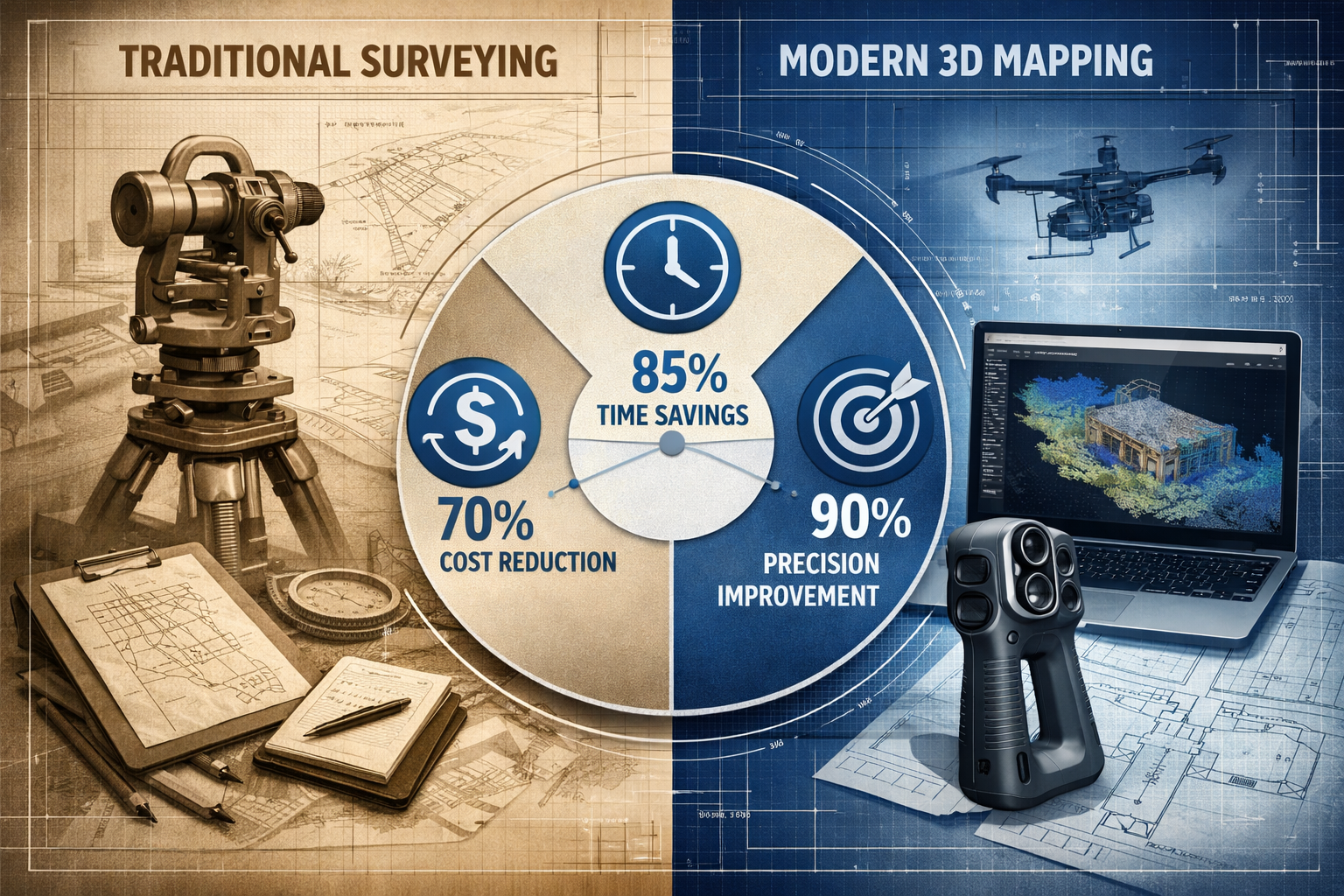
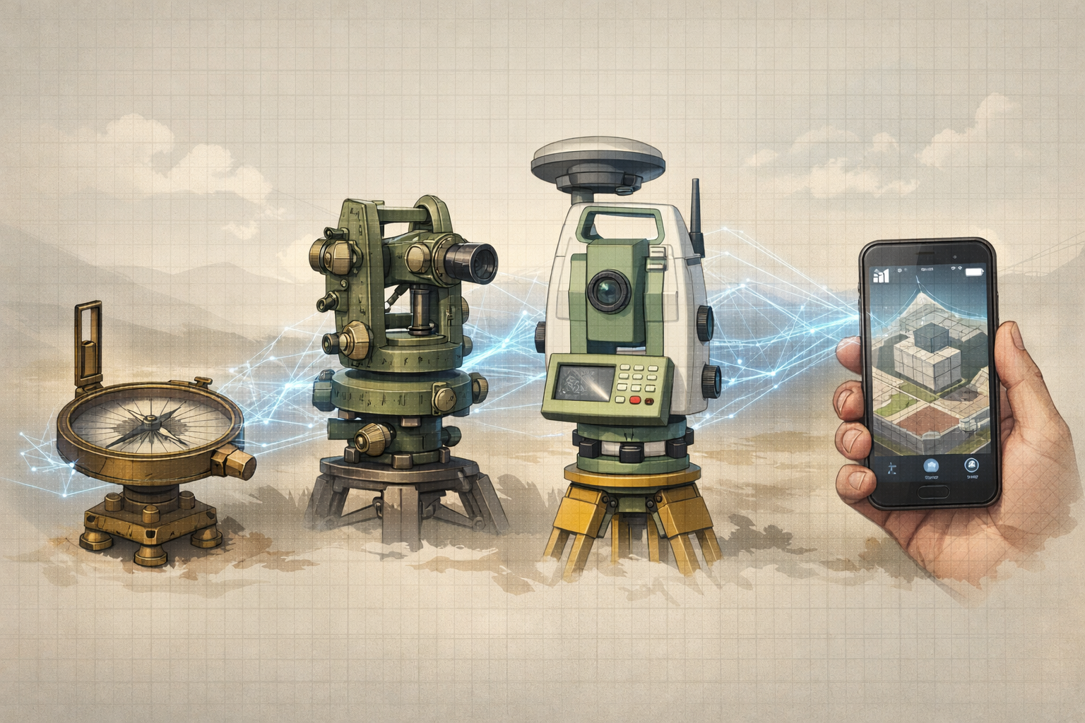
Traditional surveying has long been associated with heavy tripods, expensive total stations, and teams of specialists spending days in the field. The barrier to entry remained high—both in terms of capital investment and specialized training. A complete traditional surveying setup could easily exceed £50,000, putting comprehensive 3D mapping capabilities out of reach for smaller firms and independent practitioners.
The landscape began shifting with the introduction of Unmanned Aerial Systems (UAS), commonly known as drones. These flying platforms revolutionized the industry by offering "unprecedented accuracy, efficiency, and cost-effectiveness," according to industry analysis.[1] Drones can cover large areas in a fraction of the time required by traditional ground-based methods, dramatically reducing fieldwork labor intensity and associated project costs.
The Mobile Revolution in 3D Mapping
Perhaps the most significant accessibility breakthrough came with RTK Videogrammetry—a technology that allows surveyors to capture professional-grade 3D models using Android phones paired with RTK GNSS receivers rather than specialized drone equipment.[2] This innovation addresses a critical gap: sites with drone flight restrictions, urban environments with complex airspace regulations, or locations where trained drone pilots are unavailable.
The implications are profound. A surveyor conducting a comprehensive condition survey can now arrive with equipment that fits in a backpack, capturing millimeter-accurate 3D data that would have required a van full of equipment just five years ago.
Versatility Maximizing Return on Investment
The versatility of modern UAS and mobile mapping systems allows the same equipment to be deployed across multiple project types—from residential property assessments to commercial infrastructure surveys.[1] This flexibility maximizes return on investment and reduces overall capital expenses for surveying firms.
A single drone platform can be used for:
- Topographic surveys of construction sites
- Roof inspections for insurance valuations
- Volumetric calculations for earthwork projects
- Facade assessments of tall buildings
- Progress monitoring on development sites
This multi-purpose capability means even small firms can justify the investment, knowing the equipment will generate revenue across diverse project types rather than sitting idle between specialized assignments.
How 3D Mapping and Visualization Tools Are Making Advanced Surveying Technology Accessible and Affordable
The affordability revolution in surveying technology rests on three foundational pillars: automated processing, integrated platforms, and flexible data capture options. Each element contributes to reducing both the capital investment required and the operational costs of delivering professional surveying services.
Automated Processing: Turning Hours into Minutes
Modern photogrammetry software features automated image matching, point cloud generation, and 3D model creation that save hours of manual labor.[1] What once required a skilled technician spending days manually processing survey data now happens automatically overnight.
The workflow transformation is remarkable:
| Traditional Workflow | Modern Automated Workflow |
|---|---|
| Manual ground control point placement | Automated GCP detection |
| Individual image alignment | Batch processing of hundreds of images |
| Manual point cloud cleaning | AI-powered noise filtering |
| Separate software for each output type | Single-platform multi-format export |
| 3-5 days processing time | 4-8 hours processing time |
This efficiency directly translates to cost savings. A Level 3 building survey that once required extensive manual documentation can now be supplemented with comprehensive 3D models at minimal additional cost.
Platform Integration: One Tool Instead of Five
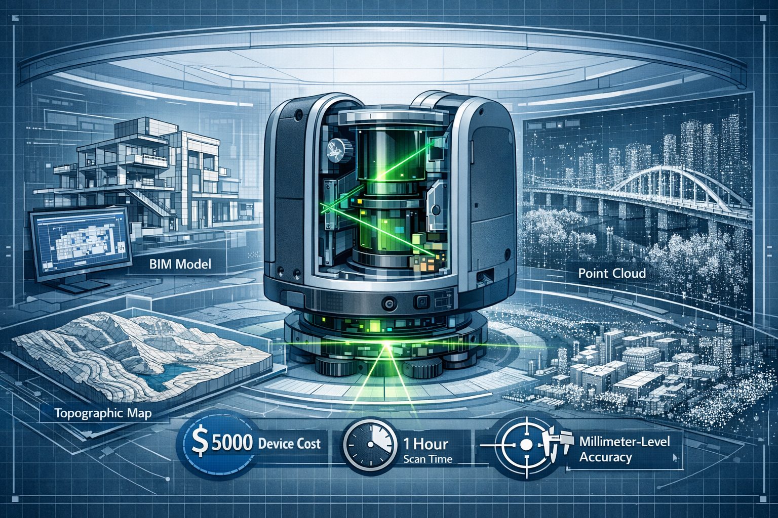
3Dsurvey, positioned as the leading photogrammetry software in 2026, exemplifies the integrated platform approach.[2] It supports all major data sources—drones, LiDAR, GNSS, SLAM, and sonar—in a single environment, reducing the need for multiple specialized tools and lowering operational complexity.
The platform includes built-in CAD tools specifically designed for surveyors, eliminating the need for separate software purchases for vectorization, volume calculations, and digital terrain modeling.[2] This integration addresses a pain point that has historically inflated costs: the need to maintain multiple software licenses, each requiring training and technical support.
🔑 Key advantage: Surveyors can import drone imagery, process it into a point cloud, create a 3D mesh, perform measurements, generate CAD drawings, and export to client-specified formats—all without leaving a single software environment.
The ecosystem maturity is evident in 3Dsurvey's network of over 70 partners globally, indicating widespread adoption across the surveying industry.[2]
Multi-Format Export: Avoiding Vendor Lock-In
Accessibility isn't just about affordable entry points—it's also about freedom to integrate with existing workflows. Modern platforms support standard export formats including DXF, SHP, PDF, XYZ, TIFF, PLY, and OBJ, enabling seamless integration with existing CAD, GIS, and regulatory systems without vendor lock-in.[2]
This interoperability matters tremendously for smaller firms that may already have established relationships with clients expecting deliverables in specific formats. The ability to export to industry-standard formats means adopting new 3D mapping technology doesn't require clients to change their workflows—a critical factor in adoption.
For professionals conducting RICS building surveys, the ability to supplement traditional reports with 3D models exported to PDF for client review or DXF for architect collaboration adds significant value without creating compatibility headaches.
Expanding Access: Surveying Previously Inaccessible or Dangerous Locations
One of the most compelling arguments for 3D Mapping and Visualization Tools: Making Advanced Surveying Technology Accessible and Affordable is their ability to make the impossible routine. UAS technology enables safe access to hard-to-reach or unstable areas such as steep terrain and unstable structures without putting surveyors at risk.[1]
Safety Meets Affordability
Traditional surveying of dangerous locations required:
- Scaffolding or aerial work platforms (£2,000-£10,000+ per project)
- Rope access specialists (£500-£1,500 per day)
- Extensive safety protocols and insurance (significant overhead)
- Extended project timelines (increasing labor costs)
Modern drone and mobile mapping approaches eliminate most of these expenses. A surveyor can safely capture comprehensive data of a deteriorating facade, unstable cliff face, or hazardous industrial structure from a safe distance, completing in hours what might have taken days with traditional methods.
This capability is particularly valuable for:
✅ Heritage building assessments where physical access might damage delicate structures
✅ Post-disaster evaluations where structural stability is uncertain
✅ Industrial facility surveys with hazardous materials or processes
✅ Steep terrain mapping for development feasibility studies
✅ Bridge and infrastructure inspections over water or traffic
When conducting drainage surveys or structural assessments, the ability to capture comprehensive external and contextual data without physical access reduces both risk and cost.
Restricted Airspace Solutions
While drones have revolutionized many aspects of surveying, urban environments often present airspace restrictions that limit their use. This is where mobile 3D mapping technology truly shines. As of 2026, surveying firms are creating digital twins "without bulky equipment," using handheld or backpack-mounted systems that can operate in any environment.[4]
These systems are particularly valuable for:
- Urban property surveys in flight-restricted zones
- Interior building documentation where drones cannot operate
- Underground infrastructure mapping in tunnels and basements
- Dense urban canyons where GPS signals are limited
The flexibility to choose the right tool for each environment—drone, mobile scanner, or smartphone-based RTK system—means no project is automatically too expensive or technically impossible.
The Digital Twin Revolution: From Point-in-Time to Continuous Documentation
The surveying industry is experiencing a fundamental shift in how projects are documented and monitored. As of February 2026, surveying firms are increasingly adopting advanced tools like digital twins for construction monitoring and infrastructure assessment, marking a transition from point-in-time surveys to continuous digital documentation.[6]
What Are Digital Twins in Surveying Context?
A digital twin is a virtual replica of a physical asset that can be updated throughout its lifecycle. In surveying applications, this means creating an initial comprehensive 3D model and then updating it periodically to track changes, monitor construction progress, or assess deterioration over time.
This approach offers several advantages over traditional periodic surveys:
📊 Change detection: Automated comparison between survey epochs highlights exactly what has changed
📈 Progress tracking: Construction projects can be monitored against planned timelines with visual evidence
🔍 Defect identification: Deviations from design specifications are immediately apparent
💾 Historical record: Complete documentation of a structure's evolution over time
For commercial property surveyors, digital twins enable ongoing monitoring of large portfolios without the expense of repeated comprehensive surveys. Changes can be documented with targeted updates rather than starting from scratch each time.
Making Digital Twins Affordable
The affordability of digital twin creation in 2026 stems from the same technological advances making initial surveys more accessible:
- Rapid data capture: Drone or mobile mapping systems can resurvey a site in hours
- Automated change detection: Software automatically identifies differences between survey epochs
- Cloud-based collaboration: Stakeholders can access the digital twin without expensive software licenses
- Incremental updates: Only changed areas need detailed resurveying
This efficiency means digital twins are no longer exclusive to major infrastructure projects. Even residential developments and smaller commercial properties can benefit from continuous documentation at reasonable costs.
Industry Momentum and Adoption
The strategic importance of this shift is evident in industry events. Geo Week 2026 (February 16-18, Denver) showcased drone innovations and reality capture technology, with the Reality Capture Network hosting strategic sessions on the sector's direction.[5][7] The convergence of surveying, construction technology, and digital documentation at major industry conferences signals that digital twins and continuous monitoring are becoming standard practice rather than cutting-edge experiments.
Practical Applications: Real-World Cost Savings and Accessibility Gains
Understanding the theoretical benefits of accessible 3D mapping technology is valuable, but examining practical applications demonstrates the real-world impact on surveying firms and their clients.
Residential Property Surveys
For homebuyers commissioning a Level 2 survey, the addition of comprehensive 3D documentation has become increasingly affordable. A surveyor can capture drone imagery of the roof and exterior, mobile mapping data of the interior, and deliver both a traditional written report and an interactive 3D model for minimal additional cost.
Traditional approach cost breakdown:
- Site visit: 4-6 hours
- Report writing: 6-8 hours
- Total professional time: 10-14 hours
- Equipment: Standard measuring tools
Modern enhanced approach:
- Site visit with 3D capture: 3-4 hours (faster with automated documentation)
- Automated processing: 4-6 hours (mostly unattended)
- Report writing with 3D reference: 4-6 hours (faster with precise measurements)
- Total professional time: 7-10 hours
- Equipment: Drone or mobile scanner (amortized across many projects)
The enhanced approach actually reduces billable hours while delivering superior documentation, making it both more affordable for clients and more profitable for surveyors.
Construction Progress Monitoring
A residential development with 50 units traditionally required monthly site visits by surveyors to document progress. With modern 3D mapping approaches:
Before:
- Monthly site visit: 1 full day per surveyor
- Manual measurement and documentation: 2 days
- Report preparation: 1 day
- Total: 4 days per month = 48 days annually
- Cost: £24,000-£36,000 annually
After (with drone and automated processing):
- Monthly drone flight: 1 hour
- Automated processing: 4 hours (unattended)
- Review and report: 4 hours
- Total: 1 day per month = 12 days annually
- Cost: £6,000-£9,000 annually
The 75% cost reduction makes continuous monitoring economically viable for projects where it would have been prohibitively expensive using traditional methods.
Commercial Building Assessments
When conducting commercial building surveys, the ability to capture comprehensive facade data without scaffolding or aerial platforms represents enormous cost savings.
A recent example: A five-story commercial building requiring facade condition assessment for a dilapidations survey.
Traditional approach:
- Scaffolding or cherry picker rental: £8,000-£15,000
- Extended survey time: 3-5 days
- Safety protocols and insurance: £2,000-£3,000
- Total additional cost: £10,000-£18,000
Drone-based approach:
- Drone survey: 2-3 hours
- Processing and analysis: 1 day
- Additional cost: £1,500-£2,500
The tenfold cost reduction makes comprehensive facade surveys economically viable for routine maintenance planning rather than only emergency assessments.
Choosing the Right 3D Mapping Solution for Your Needs
With the proliferation of accessible 3D mapping technologies, selecting the appropriate solution requires understanding the specific requirements of your surveying practice and typical project types.
Technology Comparison Matrix
| Technology | Initial Investment | Best Applications | Limitations | Accessibility Level |
|---|---|---|---|---|
| Smartphone RTK | £2,000-£5,000 | Small sites, interiors, restricted airspace | Limited range, slower coverage | ⭐⭐⭐⭐⭐ Highest |
| Consumer Drones | £1,500-£5,000 | Small to medium sites, basic documentation | Limited accuracy, weather dependent | ⭐⭐⭐⭐ Very High |
| Professional Drones | £8,000-£25,000 | Large sites, high accuracy requirements | Regulatory compliance, training | ⭐⭐⭐ Moderate |
| Mobile Mapping Backpacks | £15,000-£40,000 | Interior spaces, urban environments | Processing complexity | ⭐⭐ Lower |
| Terrestrial LiDAR | £30,000-£100,000+ | Highest accuracy, complex structures | Cost, specialized training | ⭐ Lowest |
Decision Framework
When evaluating which technology to adopt, consider these questions:
🔍 What are your typical project sizes?
Small residential properties benefit most from smartphone RTK or consumer drones, while large commercial sites may justify professional-grade equipment.
🔍 What accuracy levels do clients require?
RICS registered valuers conducting formal valuations may need higher precision than general condition surveys.
🔍 What is your project volume?
Higher equipment costs can be justified with greater project throughput. Calculate the payback period based on realistic project numbers.
🔍 What environments do you typically survey?
Urban practitioners may find mobile mapping systems more valuable than drones due to airspace restrictions.
🔍 What is your team's technical capacity?
More sophisticated systems require greater training investment. Consider whether automated processing features justify higher software costs.
Software Considerations
Beyond hardware, the software platform significantly impacts both capability and ongoing costs. When evaluating photogrammetry and 3D mapping software:
✅ Integration capabilities: Does it support your data sources (drone, LiDAR, GNSS, etc.)?
✅ Export formats: Can it deliver in formats your clients require?
✅ Built-in tools: Are CAD, measurement, and analysis tools included, or do you need separate software?
✅ Automation level: How much manual intervention is required for processing?
✅ Learning curve: How quickly can your team become proficient?
✅ Support ecosystem: Are training resources, tutorials, and technical support readily available?
Platforms like 3Dsurvey that integrate multiple data sources and include comprehensive tools in a single package often provide better value than assembling a toolkit from multiple specialized applications.[2]
Training and Skill Development: Lowering the Knowledge Barrier
The accessibility of modern 3D mapping technology extends beyond equipment costs to include the learning curve required to achieve professional competency. In 2026, the barrier to entry has dropped dramatically compared to even five years ago.
Automated Processing Reduces Expertise Requirements
Traditional photogrammetry required deep technical knowledge of camera calibration, bundle adjustment, and manual point cloud editing. Modern software automates most of these processes, allowing surveyors to focus on data collection and interpretation rather than technical processing details.[1]
This democratization means a surveyor with traditional chartered surveyor qualifications can add 3D mapping capabilities with weeks of training rather than years of specialized study.
Abundant Learning Resources
The maturity of the 3D mapping ecosystem has produced extensive learning resources:
- Manufacturer training programs: Equipment and software vendors offer comprehensive training
- Online courses: Platform-specific and general photogrammetry courses widely available
- YouTube tutorials: Free step-by-step guides for specific workflows
- Industry conferences: Events like Geo Week 2026 provide hands-on workshops[5][7]
- Professional associations: RICS and similar organizations offer continuing professional development
Practical Skill Development Path
For surveying firms adding 3D mapping capabilities, a structured approach accelerates competency development:
Phase 1: Foundation (Weeks 1-2)
- Equipment familiarization and safety protocols
- Basic flight operations or mobile scanning techniques
- Software interface and basic processing workflows
Phase 2: Application (Weeks 3-6)
- Practice projects on non-critical assignments
- Processing optimization and quality control
- Integration with existing survey workflows
Phase 3: Refinement (Weeks 7-12)
- Advanced processing techniques
- Challenging environments and edge cases
- Efficiency optimization and client deliverable formatting
Phase 4: Mastery (Ongoing)
- Complex project types
- Multi-sensor integration
- Custom workflows for specific applications
This timeline is dramatically shorter than the years required to master traditional advanced surveying techniques, making 3D mapping accessible to practitioners at any career stage.
Regulatory Considerations and Professional Standards
While technology has become more accessible, professional surveyors must still navigate regulatory requirements and maintain professional standards when adopting 3D mapping tools.
Drone Regulations in the UK
Operating drones for commercial surveying in the UK requires compliance with Civil Aviation Authority (CAA) regulations:
- Operator registration: Required for commercial operations
- Pilot certification: GVC (General VLOS Certificate) or equivalent
- Operational authorizations: Required for certain flight scenarios
- Insurance: Public liability coverage mandatory
- Airspace awareness: Understanding flight restrictions and notification requirements
The good news is that obtaining basic commercial drone certification has become more streamlined in 2026, with online training and testing reducing both time and cost barriers.
Professional Standards for 3D Survey Data
When delivering 3D mapping data as part of professional surveying services, maintaining standards is essential:
📋 Accuracy specifications: Clearly document the precision of delivered data
📋 Metadata requirements: Include capture dates, equipment used, processing methods
📋 Quality assurance: Implement check measurements and validation procedures
📋 Data formats: Deliver in formats appropriate for the intended use
📋 Professional liability: Ensure insurance coverage extends to 3D mapping deliverables
For surveyors conducting RICS home surveys, supplementing traditional reports with 3D data requires the same professional rigor as any other deliverable.
Data Privacy and Security
3D mapping often captures more information than traditional surveys, raising privacy considerations:
- Neighboring properties: Drone and mobile mapping may inadvertently capture adjacent properties
- Personal information: Ensure people are not identifiable in captured imagery
- Data storage: Implement secure storage and transmission protocols
- Client confidentiality: Protect proprietary information visible in 3D models
Establishing clear protocols for data handling ensures compliance with GDPR and maintains client trust.
Future Trends: What's Next for Accessible 3D Mapping?
The trajectory of 3D mapping technology suggests continued democratization and capability expansion. Several trends emerging in 2026 point toward even greater accessibility in coming years.
Artificial Intelligence Integration
AI-powered processing is moving beyond basic automation to intelligent interpretation:
- Automated defect detection: AI identifying potential structural issues in 3D models
- Change detection: Intelligent algorithms highlighting significant alterations between survey epochs
- Measurement extraction: Automated generation of dimensions and quantities from 3D data
- Classification: Automatic identification and labeling of building elements
These capabilities will further reduce the specialized knowledge required to extract value from 3D survey data.
Cloud-Based Processing
Cloud platforms are eliminating the need for powerful local workstations:
- Upload and process: Capture data in the field, upload, and receive processed results
- Scalable computing: Access high-performance processing without capital investment
- Collaboration: Multiple stakeholders accessing the same dataset simultaneously
- Storage: Eliminate local storage requirements for large 3D datasets
This trend particularly benefits smaller firms without IT infrastructure for processing large photogrammetry projects.
Augmented Reality Integration
AR visualization is making 3D survey data more accessible to non-technical clients:
- On-site visualization: View 3D models overlaid on real-world locations using tablets or phones
- Design comparison: Compare proposed changes against existing conditions in real-time
- Client presentations: Interactive walkthroughs more engaging than static reports
For surveyors conducting Level 2 vs Level 3 surveys, AR presentation of findings could enhance client understanding and decision-making.
Sensor Fusion Advancement
The integration of multiple sensor types in single platforms continues to advance:
- Simultaneous drone and ground capture: Coordinated data collection for complete coverage
- Multi-spectral imaging: Combining visible, thermal, and near-infrared data
- Real-time processing: Immediate feedback on data quality during capture
These developments will further reduce the need for multiple specialized systems, lowering costs and complexity.
Cost-Benefit Analysis: Calculating ROI for Your Practice
For surveying firms considering investment in 3D mapping technology, a structured cost-benefit analysis helps justify the decision and select appropriate solutions.
Initial Investment Components
Hardware costs:
- Drone or mobile mapping system: £2,000-£25,000
- RTK GNSS receiver (if needed): £3,000-£8,000
- Processing workstation (if not cloud-based): £1,500-£3,000
- Accessories (batteries, cases, etc.): £500-£1,500
Software costs:
- Photogrammetry platform: £1,500-£5,000 annually
- CAD/GIS integration tools: £500-£2,000 annually
- Cloud processing credits: Variable based on usage
Training and certification:
- Drone pilot certification: £1,000-£2,000
- Software training: £500-£1,500
- Initial practice projects: £1,000-£2,000 (time investment)
Total typical investment: £10,000-£50,000 depending on chosen technology level
Revenue Enhancement Opportunities
New service offerings:
- 3D documentation premium: £500-£2,000 per project
- Progress monitoring contracts: £5,000-£20,000 annually per client
- Digital twin creation: £3,000-£15,000 per property
- Specialized access surveys: £2,000-£8,000 per project
Efficiency gains:
- Reduced site visit time: 30-50% time savings
- Faster report preparation: 20-40% time savings
- Fewer return visits: Comprehensive initial capture reduces callbacks
- Expanded service area: Faster surveys enable serving more clients
Sample ROI Calculation
Scenario: Mid-sized surveying firm investing £25,000 in professional drone system and software
Monthly project additions:
- 4 enhanced residential surveys with 3D documentation: +£2,000 revenue
- 1 commercial facade survey: +£3,000 revenue
- 1 progress monitoring contract: +£1,500 revenue
- Efficiency gains on existing projects: +£2,000 (time freed for additional work)
Monthly revenue increase: £8,500
Annual revenue increase: £102,000
Payback period: 3 months
First-year ROI: 308%
Even conservative assumptions typically show payback periods under 12 months for firms with steady project flow.
Overcoming Common Implementation Challenges
While 3D mapping technology has become more accessible, surveying firms still encounter challenges during implementation. Understanding common obstacles and solutions accelerates successful adoption.
Challenge 1: Client Education
Problem: Clients may not understand the value of 3D documentation or resist paying for enhanced services.
Solutions:
- Provide sample 3D models from demonstration projects
- Create before/after comparisons showing traditional vs. 3D documentation
- Offer initial projects at reduced rates to demonstrate value
- Develop clear communication materials explaining benefits in client terms
- Show how 3D data supports better decision-making and reduces future costs
Challenge 2: Workflow Integration
Problem: Adding new technology disrupts established workflows and creates temporary inefficiency.
Solutions:
- Implement gradually, starting with non-critical projects
- Develop standardized procedures and checklists
- Create templates for common deliverable types
- Establish quality control checkpoints
- Allow extra time initially until processes are refined
Challenge 3: Weather and Environmental Limitations
Problem: Drone operations are weather-dependent, potentially causing scheduling challenges.
Solutions:
- Maintain flexible scheduling with buffer time
- Develop hybrid approaches (mobile mapping for poor weather days)
- Communicate limitations clearly to clients during booking
- Build weather contingencies into project timelines
- Consider investing in multiple capture methods for flexibility
Challenge 4: Data Management
Problem: 3D datasets are large, creating storage and organization challenges.
Solutions:
- Implement cloud storage solutions with appropriate capacity
- Develop consistent file naming and organization conventions
- Establish data retention policies (how long to keep raw vs. processed data)
- Use cloud processing to avoid local storage of intermediate files
- Regular backup protocols for valuable datasets
Challenge 5: Keeping Current with Technology
Problem: Rapid technology evolution creates pressure to continuously upgrade.
Solutions:
- Focus on software updates rather than constant hardware replacement
- Join professional networks to share knowledge about new developments
- Attend industry events like Geo Week to stay informed[5][7]
- Evaluate new technology based on client needs rather than features alone
- Plan equipment refresh cycles (typically 3-5 years for hardware)
Conclusion: Embracing the Accessible Future of Surveying
The transformation of 3D Mapping and Visualization Tools: Making Advanced Surveying Technology Accessible and Affordable represents more than just technological advancement—it's a fundamental democratization of professional capabilities that were recently exclusive to large, well-capitalized firms. In 2026, surveyors of all practice sizes can deliver comprehensive digital documentation that enhances traditional surveying services while reducing costs and improving safety.
The convergence of mobile technology, automated processing, integrated platforms, and flexible data capture options has created an ecosystem where the barriers to entry continue falling. Whether capturing building survey data with a smartphone RTK system, documenting construction progress with consumer drones, or creating comprehensive digital twins of commercial properties, the tools are now within reach of practitioners committed to enhancing their service offerings.
The benefits extend beyond individual surveying firms to the entire property ecosystem. Homebuyers gain access to more comprehensive property assessments at reasonable costs. Construction projects benefit from continuous monitoring that catches issues early. Infrastructure owners can maintain detailed digital records supporting better long-term planning. The accessibility revolution in 3D mapping creates value throughout the chain.
Actionable Next Steps
For surveying professionals ready to embrace these accessible technologies:
- Assess your practice needs: Review your typical project types and identify where 3D mapping would add most value
- Start small and focused: Begin with entry-level technology targeting your highest-value application rather than trying to cover all possibilities
- Invest in training: Allocate time and resources for proper skill development—technology is only valuable when properly utilized
- Develop clear service offerings: Create specific packages incorporating 3D documentation so clients understand what they're purchasing
- Build a demonstration portfolio: Complete several projects to showcase capabilities to prospective clients
- Join professional networks: Connect with other practitioners through industry associations and events to share knowledge and best practices
- Stay informed: Monitor industry developments through conferences like Geo Week and professional publications to identify emerging opportunities
The future of surveying is not about replacing traditional skills with technology—it's about enhancing professional judgment with comprehensive data capture and visualization tools that were previously inaccessible. The firms that thrive in this new landscape will be those that recognize 3D mapping not as an expensive specialty but as an increasingly essential component of modern professional practice.
The question is no longer whether to adopt these technologies, but how quickly to implement them before they become standard client expectations rather than competitive differentiators. The accessibility is here. The affordability is proven. The opportunity awaits action.
References
[1] Surveying And Mapping With Uas – https://www.datumate.com/blog/surveying-and-mapping-with-uas/
[2] 3dsurvey Is The Best Photogrammetry Software In 2026 – https://3dsurvey.si/3dsurvey-is-the-best-photogrammetry-software-in-2026/
[4] Mobile 3d Mapping Creating Digital Twins Without Bulky Equipment – https://nottinghillsurveyors.com/blog/mobile-3d-mapping-creating-digital-twins-without-bulky-equipment
[5] Geo Week 2026 Highlights Reality Capture S Strategic Role – https://www.gim-international.com/content/news/geo-week-2026-highlights-reality-capture-s-strategic-role
[6] Around The Geospatial 3d And Aec Industries Digital Ai And Drone Imagery – https://www.geoweeknews.com/news/around-the-geospatial-3d-and-aec-industries-digital-ai-and-drone-imagery
[7] Geo Week 2026 To Showcase Drone Innovations – https://www.commercialuavnews.com/geo-week-2026-to-showcase-drone-innovations