
Property owners, developers, and homebuyers face a complex landscape when it comes to understanding land survey costs in 2026. With inflation pressures, technological advancements, and a booming construction market reshaping the surveying industry, knowing what to expect financially has never been more critical. Whether you're purchasing a new home, subdividing land, or planning a major construction project, the cost of a professional land survey can significantly impact your budget—ranging from as little as $200 for basic mortgage surveys to upwards of $25,000 for extensive commercial properties.
This comprehensive guide breaks down Land Survey Costs in 2026: Complete Pricing Guide and Factors Driving Increases, providing property owners and developers with the detailed pricing information, regional comparisons, and budgeting strategies needed to make informed decisions. Understanding these costs upfront helps prevent unexpected expenses and ensures compliance with legal requirements.
Key Takeaways
- 💰 National average land survey cost in 2026 is $2,300, with typical ranges between $800 and $5,500 depending on survey type and property characteristics
- 📊 Survey type dramatically affects pricing: Mortgage surveys start at $200-$700, while comprehensive ALTA surveys range from $1,200-$10,000
- 📏 Property size is the primary cost driver: Half-acre lots cost $300-$2,000, while 50-acre parcels can exceed $10,000-$25,000
- 🌍 Regional variations are significant: Urban areas and coastal regions command 30-50% higher rates than rural Midwest locations
- 🚁 Technology adoption in 2026 including drone surveys and GPS equipment is both increasing accuracy and creating new pricing tiers
Understanding Land Survey Costs in 2026: What Property Owners Need to Know
Land surveys serve as the foundation for property transactions, construction projects, and boundary disputes. In 2026, the surveying industry continues to evolve with technological innovations while facing economic pressures that influence pricing structures.
What Is a Land Survey?
A land survey is a professional assessment conducted by licensed surveyors to determine the precise boundaries, topography, and features of a property. These detailed measurements create legal documentation that protects property rights, facilitates transactions, and ensures construction projects comply with zoning regulations.
Professional surveyors use advanced equipment including GPS technology, total stations, and drone imagery to capture accurate measurements. The resulting survey documents typically include property boundary markers, easements, encroachments, topographical features, and improvements on the land.
Why Land Survey Costs Matter in 2026
The construction boom continuing into 2026 has created unprecedented demand for surveying services. Combined with inflation affecting labor costs and equipment investments, property owners face higher baseline prices than in previous years. Understanding these costs helps with:
- Budget planning for property purchases or development projects
- Avoiding disputes with neighbors over boundary lines
- Meeting lender requirements for mortgage approval
- Ensuring compliance with local zoning and building codes
- Protecting property investments through accurate documentation
For those exploring property transactions, understanding survey requirements is as important as knowing about building surveys and other property assessments.
Complete Pricing Breakdown: Land Survey Costs in 2026 by Type
Different survey types serve distinct purposes and come with varying price points. Understanding these differences helps property owners select the appropriate survey level for their specific needs.
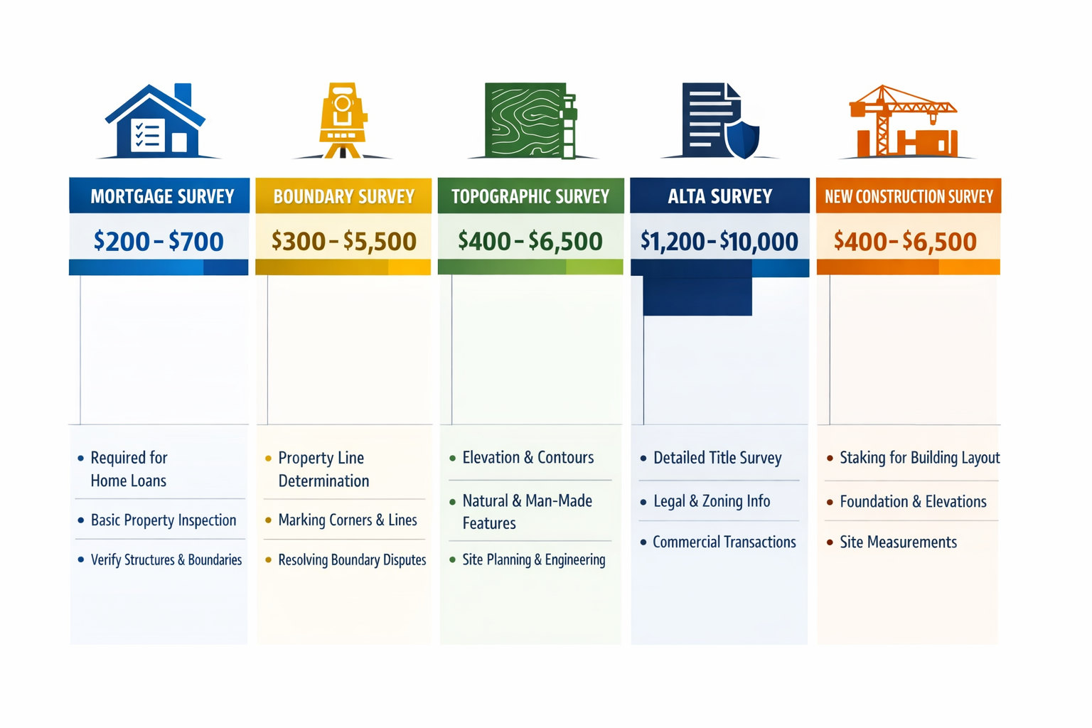
Mortgage Survey (Lowest Cost Option)
Price Range: $200–$1,500
Also known as a drive-by or location survey, the mortgage survey represents the most basic and affordable option. Lenders often require this minimal assessment to verify that structures exist on the property and don't violate setback requirements.
What's Included:
- Basic property outline
- Location of major structures
- Verification of property address
- Simple sketch or diagram
Best For: Standard residential mortgage approvals where detailed boundary information isn't critical
Limitations: Does not establish legal boundaries or identify encroachments[1][2]
Boundary Survey
Price Range: $300–$5,500
Boundary surveys represent the most commonly requested survey type for residential properties. These surveys establish or re-establish property lines with legal precision, placing physical markers at corner points.
What's Included:
- Precise property boundary measurements
- Corner markers and monuments
- Identification of easements
- Detection of encroachments
- Legal description verification
- Comparison with deed records
Best For: Property purchases, fence installations, resolving boundary disputes, or subdivision planning
Average Costs by Property Size:[3][4]
- Quarter-acre: $300–$600
- Half-acre: $500–$1,000
- One acre: $800–$1,500
- Two acres: $1,000–$2,500
Understanding property boundaries is crucial, particularly when dealing with party wall agreements that affect shared structures between properties.
Topographic Survey
Price Range: $400–$6,500
Topographic surveys map the elevation changes, contours, and natural features of a property. Architects, engineers, and developers rely on these detailed surveys for construction planning and site design.
What's Included:
- Elevation measurements and contour lines
- Location of natural features (trees, streams, rocks)
- Existing structures and improvements
- Utility locations
- Drainage patterns
- Grade changes
Best For: New construction projects, site development, drainage planning, and architectural design
Cost Factors: Terrain complexity, vegetation density, and required detail level significantly impact pricing[2][3]
ALTA Survey (Most Comprehensive)
Price Range: $1,200–$10,000
The American Land Title Association (ALTA) survey represents the gold standard for commercial real estate transactions. These comprehensive surveys meet strict national standards and provide extensive detail required by title insurance companies and commercial lenders.
What's Included:
- All boundary survey elements
- Topographic information
- Improvements and structures
- Easements and rights-of-way
- Zoning classification
- Flood zone designation
- Underground utilities
- Access points and parking
- Title commitment review
Best For: Commercial property transactions, large-scale developments, and complex real estate deals
Why More Expensive: ALTA surveys require extensive research, detailed fieldwork, and comprehensive documentation meeting specific national standards[2][5]
New Construction Survey
Price Range: $400–$6,500
Construction surveys guide builders throughout the development process, ensuring structures are placed correctly according to plans and local regulations.
What's Included:
- Initial site layout and staking
- Foundation verification
- As-built documentation
- Final elevation certificates
- Multiple site visits during construction phases
Best For: Residential and commercial construction projects requiring multiple survey stages
Similar to how construction surveys guide building projects, land surveys ensure proper site preparation and compliance.
Subdivision Survey
Price Range: $2,000–$15,000+
When dividing a single parcel into multiple lots, subdivision surveys create the legal framework for separate property ownership.
What's Included:
- Boundary survey of entire parcel
- Division into individual lots
- New legal descriptions for each lot
- Road and utility easements
- Compliance verification with local subdivision regulations
- Plat preparation for recording
Best For: Land developers, property owners dividing family land, or investors creating buildable lots
Cost Variables: Number of lots created, local regulatory requirements, and existing survey availability[3]
Primary Factors Driving Land Survey Costs in 2026
Multiple variables influence the final cost of a land survey. Understanding these factors helps property owners anticipate expenses and potentially reduce costs through strategic planning.
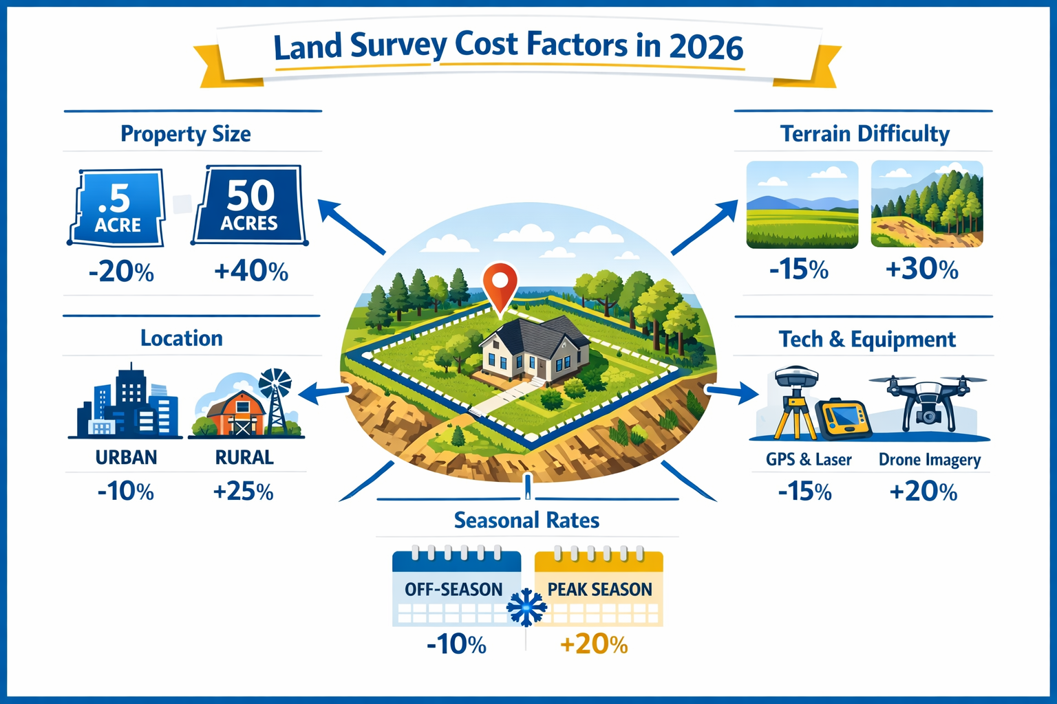
Property Size and Acreage
Property size remains the single most significant cost determinant. Larger parcels require more time, labor, and equipment to survey accurately.
2026 Average Costs by Acreage:[3][4]
| Property Size | Price Range | Average Cost |
|---|---|---|
| Quarter-acre | $300–$800 | $550 |
| Half-acre | $300–$2,000 | $1,000 |
| 1 acre | $500–$3,500 | $1,500 |
| 2 acres | $800–$4,000 | $2,000 |
| 5 acres | $1,000–$4,400 | $2,500 |
| 10 acres | $1,500–$6,000 | $3,500 |
| 20 acres | $2,500–$10,000 | $5,000 |
| 50 acres | $5,000–$25,000 | $12,000 |
Why Size Matters: Surveyors charge based on the perimeter they must measure and mark, not just total acreage. Irregularly shaped properties with longer perimeters cost more than square parcels of equal size[3].
Terrain and Accessibility
The physical characteristics of your property significantly impact survey difficulty and cost.
Terrain Factors Increasing Costs:
- 🌲 Heavy vegetation: Dense woods requiring clearing or careful navigation add 20-40% to base costs
- ⛰️ Steep slopes: Hillside properties require more time and specialized equipment
- 💧 Water features: Streams, ponds, or wetlands complicate boundary determination
- 🏔️ Rocky terrain: Difficult ground conditions slow fieldwork and equipment setup
- 🚫 Limited access: Properties without road access require additional time and effort
Flat, Clear Land = Lower Costs: Open, accessible properties with minimal obstacles represent the baseline pricing tier[2][8].
Location and Regional Variations
Geographic location creates substantial pricing differences across the United States in 2026.
Regional Cost Variations:
🏙️ Urban Areas (Highest Costs):
- Major metropolitan regions: $1,000–$7,500
- High demand and limited surveyor availability
- Complex property histories requiring extensive research
- Higher operating costs for surveying firms
🌾 Rural Areas (Moderate Costs):
- Countryside and small towns: $500–$3,500
- Lower overhead for surveying companies
- Simpler property records
- Potentially larger travel distances
🏖️ Coastal Regions (Premium Pricing):
- Beachfront and waterfront properties: +30-50% premium
- Additional complexity from tidal zones
- Specialized equipment requirements
- Higher property values justifying detailed surveys
💰 Cost of Living Impact: States with higher wages and operating costs (California, New York, Massachusetts) consistently show 40-60% higher survey costs than Midwest states (Iowa, Nebraska, Oklahoma)[3][4].
Survey Type Complexity
As outlined in the pricing breakdown section, survey type fundamentally determines cost. The relationship between complexity and price follows a clear progression:
Complexity Ladder (Least to Most Expensive):
- Mortgage/Location Survey
- Boundary Survey
- Topographic Survey
- New Construction Survey
- Subdivision Survey
- ALTA/Commercial Survey
Each step up the complexity ladder adds research requirements, fieldwork time, and documentation detail[2][5].
Property History and Records
The availability and quality of existing survey records significantly affect costs.
Factors Affecting Research Time:
- Recent surveys available: Can reduce costs by 15-25% when surveyors can reference recent work
- Missing or unclear records: Require extensive research adding $200–$800
- Boundary disputes: Properties with contested lines need additional investigation
- Multiple ownership changes: Complex title histories increase research time
- Old or inaccurate deeds: Vague legal descriptions require more fieldwork to resolve
Pro Tip: Providing your surveyor with any existing surveys, deeds, or plats can reduce research time and lower costs[6].
Technology and Equipment Requirements
In 2026, surveying technology continues advancing, creating both cost efficiencies and premium service tiers.
Modern Surveying Technologies:
- 🛰️ GPS/GNSS Systems: High-precision satellite positioning for accurate measurements
- 🚁 Drone Surveys: Aerial photogrammetry for topographic mapping (adds $300–$1,500)
- 📱 3D Laser Scanning: Detailed site documentation for complex projects (adds $500–$2,000)
- 💻 CAD Software: Computer-aided design for professional deliverables
- 🗺️ GIS Integration: Geographic information systems for comprehensive mapping
Technology Impact on Pricing: While advanced technology increases surveyor overhead costs, it also improves efficiency. Properties requiring specialized equipment like drones or 3D scanning face premium pricing but receive superior documentation[7][8].
Seasonal Demand and Timing
Survey costs fluctuate throughout the year based on demand patterns and weather conditions.
Peak Season (Higher Costs):
- Spring and summer months (April–September)
- Construction season drives high demand
- Optimal weather conditions
- Potential 10-20% premium pricing
- Longer wait times for scheduling
Off-Season (Lower Costs):
- Late fall and winter months (November–February)
- Reduced demand creates negotiation opportunities
- Potential 10-15% discounts
- Faster scheduling availability
- Weather may limit fieldwork in northern climates
Strategic Timing: Property owners with flexible timelines can save significantly by scheduling surveys during off-peak periods[6].
Urgency and Rush Fees
Standard survey turnaround times range from 1-3 weeks depending on complexity. Expedited services command premium pricing.
Rush Service Pricing:
- Standard service: Base pricing
- One-week rush: +15-25% fee
- 48-72 hour rush: +30-50% fee
- 24-hour emergency: +50-100% fee
When Rush Fees Make Sense: Closing deadlines, construction schedules, or urgent boundary disputes may justify expedited service despite higher costs[8].
Economic Factors Driving Survey Cost Increases in 2026
Beyond property-specific variables, broader economic trends are pushing survey costs upward in 2026.
Inflation Impact on Labor and Materials
General inflation continues affecting the surveying industry through multiple channels:
Labor Cost Pressures:
- Licensed surveyor shortage driving wage competition
- Experienced professionals commanding premium rates
- Training costs for new technology adoption
- Benefits and insurance expenses increasing
Equipment and Operating Costs:
- GPS and total station equipment prices rising 8-12% annually
- Drone technology requiring ongoing investment
- Software licensing fees increasing
- Vehicle and fuel costs affecting travel expenses
- Insurance premiums for professional liability
Overall Impact: Industry analysts estimate surveying costs have increased 15-25% since 2023, with 2026 showing continued upward pressure[4][6].
Construction Boom Driving Demand
The residential and commercial construction markets remain robust in 2026, creating high demand for surveying services.
Demand Drivers:
- Housing shortage spurring new development
- Infrastructure investment from government programs
- Commercial real estate expansion
- Property subdivision for development
- Renovation and addition projects
Supply Constraints: The number of licensed surveyors hasn't kept pace with demand, allowing established firms to maintain premium pricing[7].
Regulatory Compliance Requirements
Increasing regulatory complexity adds time and cost to survey projects in 2026.
Compliance Factors:
- Stricter environmental regulations requiring additional documentation
- Enhanced flood zone mapping requirements
- Updated zoning ordinances demanding detailed verification
- Title insurance companies requiring more comprehensive surveys
- Local government review processes extending timelines
These regulatory requirements particularly affect commercial building surveys and development projects.
Technology Investment Costs
While technology improves efficiency, the capital investment required creates baseline cost pressures.
Technology Investment Areas:
- High-precision GPS systems: $20,000–$80,000 per unit
- Professional drones and sensors: $5,000–$25,000
- 3D laser scanning equipment: $30,000–$100,000
- Software subscriptions: $3,000–$10,000 annually
- Ongoing training and certification
Surveying firms must recoup these investments through service pricing, though the improved accuracy and efficiency benefit clients through better deliverables[8].
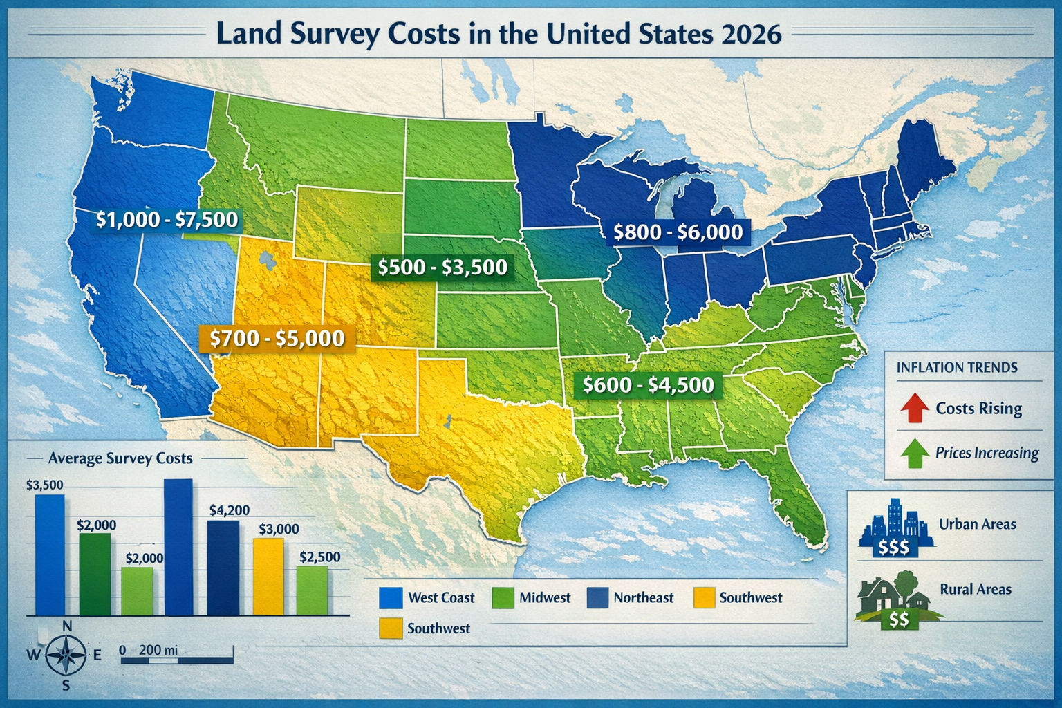
Regional Cost Comparisons: Land Survey Costs Across the United States in 2026
Understanding regional pricing variations helps property owners set realistic budget expectations based on location.
Northeast Region
States: New York, New Jersey, Pennsylvania, Massachusetts, Connecticut, Rhode Island, Vermont, New Hampshire, Maine
Average Survey Costs:
- Boundary survey (1 acre): $1,200–$3,000
- Topographic survey: $1,500–$4,500
- ALTA survey: $2,500–$8,000
Regional Factors:
- High cost of living driving labor rates
- Dense development creating complex property histories
- Strict regulatory requirements
- Limited surveyor availability in urban areas
- Older properties with unclear historical records
Notable: New York City and Boston metro areas show the highest costs nationally, with simple boundary surveys often exceeding $2,000[3][4].
Southeast Region
States: Florida, Georgia, North Carolina, South Carolina, Virginia, Tennessee, Alabama, Mississippi, Louisiana
Average Survey Costs:
- Boundary survey (1 acre): $800–$2,200
- Topographic survey: $1,000–$3,500
- ALTA survey: $1,800–$6,000
Regional Factors:
- Moderate cost of living
- High development activity in coastal areas
- Wetlands and flood zone requirements
- Hurricane-prone areas requiring elevation certificates
- Mix of urban and rural pricing
Notable: Florida coastal properties command premium pricing due to complex environmental regulations and high property values[4].
Midwest Region
States: Ohio, Indiana, Illinois, Michigan, Wisconsin, Minnesota, Iowa, Missouri, Kansas, Nebraska, North Dakota, South Dakota
Average Survey Costs:
- Boundary survey (1 acre): $600–$1,800
- Topographic survey: $800–$2,800
- ALTA survey: $1,500–$5,000
Regional Factors:
- Lower cost of living creating competitive pricing
- Abundant surveyor availability
- Simpler property histories in rural areas
- Flat terrain reducing complexity
- Agricultural land surveys at lower rates
Notable: The Midwest consistently offers the most affordable surveying costs nationally, particularly in rural areas[3].
Southwest Region
States: Texas, Oklahoma, Arkansas, New Mexico, Arizona
Average Survey Costs:
- Boundary survey (1 acre): $700–$2,400
- Topographic survey: $1,000–$3,800
- ALTA survey: $1,800–$6,500
Regional Factors:
- Rapid development in major cities (Austin, Dallas, Phoenix)
- Large property sizes common
- Desert terrain creating unique challenges
- Oil and gas industry driving commercial survey demand
- Water rights issues adding complexity
Notable: Texas shows significant variation between rural ranch land (lower costs) and urban development (premium pricing)[4].
West Coast Region
States: California, Oregon, Washington, Nevada
Average Survey Costs:
- Boundary survey (1 acre): $1,000–$3,500
- Topographic survey: $1,500–$5,000
- ALTA survey: $2,500–$10,000
Regional Factors:
- Highest cost of living nationally
- Strict environmental regulations
- Complex topography (mountains, coastline)
- High property values
- Limited surveyor availability in urban markets
- Seismic and geological considerations
Notable: California, particularly the San Francisco Bay Area and Los Angeles, shows the highest survey costs in the nation, with comprehensive surveys routinely exceeding $5,000[3][4].
Mountain Region
States: Colorado, Utah, Wyoming, Montana, Idaho
Average Survey Costs:
- Boundary survey (1 acre): $800–$2,500
- Topographic survey: $1,200–$4,000
- ALTA survey: $2,000–$7,000
Regional Factors:
- Challenging mountain terrain
- Large rural properties common
- Seasonal weather limiting fieldwork windows
- Mining and mineral rights considerations
- Remote locations increasing travel time
Notable: Mountainous terrain and accessibility challenges create higher-than-average costs despite moderate cost of living[3].
How to Budget for Your Land Survey in 2026
Strategic planning and informed decision-making help property owners manage survey costs effectively.
Getting Accurate Quotes
Request Multiple Estimates:
- Contact 3-5 licensed surveyors in your area
- Provide identical information to each for comparable quotes
- Ask for itemized pricing breaking down fieldwork, research, and deliverables
- Verify licensing and insurance coverage
- Check reviews and references
Information to Provide:
- Property address and legal description
- Approximate acreage or lot dimensions
- Survey type needed
- Purpose (mortgage, boundary dispute, construction, etc.)
- Timeline requirements
- Any existing surveys or deeds available
Red Flags: Quotes significantly below market average may indicate inexperience, cutting corners, or hidden fees[6].
Understanding What's Included
Ensure your quote includes all necessary deliverables:
Standard Inclusions:
- ✅ Field measurements and data collection
- ✅ Research of property records and deeds
- ✅ Boundary markers or monuments
- ✅ Survey drawing or plat
- ✅ Written legal description
- ✅ Professional certification and stamp
Potential Additional Costs:
- 📋 Multiple copies of survey documents
- 🗺️ Digital CAD files
- 📄 Elevation certificates
- 🔍 Title commitment review
- 📞 Expert testimony for disputes
- 🚁 Drone imagery or 3D modeling
Clarify Upfront: Discuss all potential additional fees before authorizing work to avoid surprise charges[5][6].
Cost-Saving Strategies
Provide Existing Documentation:
- Locate previous surveys, even if outdated
- Gather deed descriptions and plats
- Identify property corners if visible
- Share title insurance documents
Potential Savings: 10-20% reduction in research time[6]
Schedule During Off-Peak Season:
- Plan surveys for late fall or winter when possible
- Avoid spring and summer construction rush
- Be flexible with scheduling
Potential Savings: 10-15% seasonal discount[6]
Combine Survey Types:
- If you need both boundary and topographic information, request combined service
- Bundling reduces duplicate fieldwork
Potential Savings: 15-25% versus separate surveys[8]
Clear Property Access:
- Remove vegetation obscuring boundary lines
- Ensure surveyor can access all areas
- Identify and mark any known corners
Potential Savings: Reduced fieldwork time can save $100-$500[6]
Group Projects:
- Coordinate with neighbors for simultaneous surveys
- Subdivision developers can negotiate volume pricing
Potential Savings: 10-30% for multiple adjacent properties[8]
Financing Options
For expensive surveys exceeding several thousand dollars, consider:
Payment Plans:
- Some surveying firms offer installment payments
- Typically 50% deposit, balance on completion
- Ask about extended payment terms for large projects
Construction Loans:
- Survey costs often included in construction financing
- Lender may pay surveyor directly
Home Equity:
- Home equity loans or lines of credit
- Lower interest rates than credit cards
Project Budgeting:
- Include 10-15% contingency for unexpected survey complications
- Account for potential rush fees if timeline becomes urgent
Understanding the full scope of property assessments, including Level 3 building surveys, helps create comprehensive budgets for property transactions.
Frequently Asked Questions About Land Survey Costs in 2026
Do I Really Need a Land Survey?
While not always legally required, surveys provide critical benefits:
When Surveys Are Mandatory:
- Lender requirement for mortgage approval
- Subdivision or lot line adjustment
- New construction requiring building permits
- Title insurance for commercial properties
- Resolving boundary disputes
When Surveys Are Highly Recommended:
- Purchasing property without recent survey
- Installing fences or structures near boundaries
- Selling property to provide buyer confidence
- Identifying easements or encroachments
- Planning additions or improvements
Risk of Skipping Survey: Boundary disputes, encroachment issues, and title problems can cost far more than the survey itself[2][6].
How Long Does a Land Survey Take?
Timeline Factors:
- Simple residential boundary survey: 1-2 weeks
- Complex topographic survey: 2-4 weeks
- ALTA commercial survey: 3-6 weeks
- Large acreage or subdivision: 4-8 weeks
Process Breakdown:
- Research and preparation: 2-5 days
- Fieldwork: 1-3 days for typical residential
- Data processing and drawing: 3-7 days
- Review and certification: 1-2 days
Rush Services: Available for 25-100% premium pricing[6]
For comparison, how long a homebuyer's survey takes provides similar timeline considerations for property assessments.
Can I Survey My Own Property?
Legal Limitations:
- Only licensed professional surveyors can create legally valid surveys
- Self-surveys have no legal standing for boundary disputes
- Lenders and title companies won't accept amateur surveys
- State laws prohibit unlicensed surveying for compensation
DIY Options:
- Informal property measurements for planning purposes
- Locating existing survey markers
- Rough estimates for landscaping projects
Bottom Line: Professional surveys are necessary for any legal, financial, or construction purposes[1][6].
What's the Difference Between a Survey and an Appraisal?
Land Survey:
- Measures physical boundaries and features
- Conducted by licensed surveyor
- Focuses on property lines, topography, improvements
- Creates legal documentation of boundaries
- Required for construction and boundary verification
Property Appraisal:
- Determines market value
- Conducted by licensed appraiser
- Focuses on comparable sales and property condition
- Creates opinion of value for lending purposes
- Required for mortgage financing
Both May Be Needed: Most property transactions require both surveys and appraisals serving different purposes[6].
Understanding various property assessments, including RICS valuations, helps distinguish between different professional services.
Will My Survey Be Valid Forever?
Survey Validity Depends On:
Still Valid When:
- No property changes or improvements
- No boundary disputes or questions
- Lender accepts age (typically under 5-10 years)
- No changes to adjacent properties
- Survey meets current standards
New Survey Needed When:
- Property improvements or additions made
- Boundary disputes arise
- Lender requires current survey
- Subdivision or lot line changes
- Previous survey doesn't meet ALTA standards
- Significant time has passed (10+ years)
Best Practice: Even valid older surveys should be verified by current surveyor before relying on them for major decisions[2][6].
How Do I Find a Qualified Surveyor?
Verification Steps:
- Check Licensing: Verify current state professional license
- Confirm Insurance: Professional liability and general liability coverage
- Review Experience: Ask about similar projects completed
- Check References: Contact previous clients
- Verify Credentials: Professional associations (NSPS, state societies)
Where to Find Surveyors:
- State licensing board directories
- National Society of Professional Surveyors
- Local professional associations
- Real estate attorney recommendations
- Title company referrals
Warning Signs:
- Unlicensed or unwilling to provide license number
- No insurance coverage
- Significantly lower pricing than competitors
- Unwilling to provide references
- Poor communication or unprofessional behavior
Similar due diligence applies when finding qualified party wall surveyors for boundary-related work.
The Future of Land Surveying: Technology Trends Affecting Costs
Understanding emerging technologies helps property owners anticipate how surveying services will evolve beyond 2026.
Drone and Aerial Surveying
Current State in 2026:
- Widespread adoption for topographic surveys
- Rapid data collection over large areas
- High-resolution aerial imagery
- 3D terrain modeling capabilities
Cost Impact:
- Premium service: +$300-$1,500 for drone surveys
- Faster turnaround times
- More comprehensive documentation
- Better visualization for planning
Future Outlook: Costs decreasing as technology becomes standard rather than premium service[7].
Artificial Intelligence and Automation
Emerging Applications:
- Automated data processing reducing manual work
- AI-assisted boundary determination
- Machine learning for record research
- Automated drawing generation
Cost Impact:
- Potential efficiency gains reducing labor costs
- More accurate results reducing errors
- Faster turnaround times
- Initial investment costs maintaining current pricing
Timeline: Widespread adoption expected 2027-2030[8].
Mobile and Real-Time Technology
Current Capabilities:
- GPS receivers with centimeter accuracy
- Real-time data collection and processing
- Cloud-based collaboration
- Instant client access to preliminary data
Cost Impact:
- Improved efficiency offsetting equipment costs
- Better client communication
- Reduced site visits for revisions
3D Scanning and Modeling
Applications:
- Detailed as-built documentation
- Complex site visualization
- Integration with BIM (Building Information Modeling)
- Virtual site tours and analysis
Cost Impact:
- Premium service: +$500-$2,000
- Exceptional detail and accuracy
- Valuable for complex projects
- Becoming more affordable as technology matures
Making Informed Decisions About Land Survey Costs in 2026
Armed with comprehensive knowledge about Land Survey Costs in 2026: Complete Pricing Guide and Factors Driving Increases, property owners can approach surveying needs strategically and confidently.
Key Decision Factors
Choose Survey Type Based On:
- Legal requirements for your situation
- Lender or title company specifications
- Intended property use
- Budget constraints
- Timeline requirements
Select Surveyor Based On:
- Proper licensing and credentials
- Relevant experience with your property type
- Competitive but realistic pricing
- Professional communication
- Positive references and reviews
Time Your Survey Considering:
- Seasonal pricing variations
- Project deadlines and closing dates
- Weather and field conditions
- Surveyor availability
Investment Perspective
While survey costs represent a significant expense, they provide essential protection:
Financial Protection:
- Prevents boundary disputes costing thousands in legal fees
- Identifies encroachments before purchase
- Ensures construction compliance avoiding costly corrections
- Provides legal documentation protecting property rights
Peace of Mind:
- Clear understanding of property boundaries
- Confidence in property improvements
- Professional documentation for future reference
- Compliance with all legal requirements
Long-Term Value:
- Survey becomes part of property records
- Facilitates future transactions
- Reduces questions from future buyers
- Protects against neighbor disputes
The investment in a quality survey, similar to investing in comprehensive property surveys, pays dividends through risk reduction and clarity.
Conclusion: Navigating Land Survey Costs Successfully in 2026
Understanding Land Survey Costs in 2026: Complete Pricing Guide and Factors Driving Increases empowers property owners to make informed decisions about this essential service. With national averages around $2,300 but significant variation based on survey type, property characteristics, and regional factors, proper planning ensures you receive appropriate surveying services within budget.
The key factors driving costs in 2026—inflation pressures, construction demand, technological advancement, and regulatory complexity—reflect broader economic trends while creating opportunities for property owners who understand the market. Regional variations mean a boundary survey might cost $600 in rural Iowa or $3,000 in urban California, making location-specific research essential.
Actionable Next Steps
For Property Buyers:
- Request survey information from sellers about existing documentation
- Contact 3-5 licensed surveyors for competitive quotes early in the purchase process
- Verify survey requirements with your lender and title company
- Budget appropriately based on property size and regional averages
- Review survey carefully upon completion and ask questions about any concerns
For Property Owners:
- Assess your survey needs based on planned improvements or boundary questions
- Gather existing documentation including deeds, plats, and previous surveys
- Consider timing to take advantage of off-season pricing
- Obtain multiple quotes from qualified professionals
- Maintain survey records for future reference and property transactions
For Developers:
- Factor survey costs into project budgets with 15% contingency
- Engage surveyors early in the planning process
- Explore volume pricing for multiple lots or phases
- Coordinate with other professionals (architects, engineers, attorneys)
- Ensure compliance with all local regulations and standards
Final Thoughts
While land survey costs have increased in 2026 due to economic pressures and technological advancement, the value provided remains essential for property ownership, development, and transactions. By understanding the factors affecting pricing, comparing regional costs, and implementing cost-saving strategies, property owners can obtain necessary surveying services while managing expenses effectively.
The investment in a professional land survey protects against far more expensive problems—boundary disputes, construction errors, title issues, and legal complications. As technology continues evolving and the construction market remains robust, working with qualified surveyors who provide transparent pricing and comprehensive service ensures your property interests are properly documented and protected.
Whether you're purchasing your first home, developing a subdivision, or resolving a boundary question with a neighbor, the insights provided in this comprehensive guide to Land Survey Costs in 2026: Complete Pricing Guide and Factors Driving Increases position you to navigate the surveying process confidently and cost-effectively.
References
[1] What Is The Cheapest Type Of Land Survey – https://goldenstatede.com/what-is-the-cheapest-type-of-land-survey/
[2] How Much Does Land Survey Cost – https://www.angi.com/articles/how-much-does-land-survey-cost.htm
[3] Land Survey Cost – https://homeguide.com/costs/land-survey-cost
[4] Land Survey Cost – https://todayshomeowner.com/lawn-garden/cost/land-survey-cost/
[5] Property Survey Cost Guide – https://www.inchcalculator.com/property-survey-cost-guide/
[6] Homeowners Guide Surveyor Costs Services – https://www.trustedtradienetwork.com/blog/homeowners-guide-surveyor-costs-services
[7] Land Survey Cost – https://www.mysiteplan.com/blogs/news/land-survey-cost
[8] How To Price Surveying Projects – https://www.cq-business-management-software.com/blog/how-to-price-surveying-projects/
[9] Boundary Survey Cost Price – https://haller-blanchard.com/boundary-survey-cost-price/