
The property surveying industry has witnessed a revolutionary transformation in 2026, as 3D laser scanning technology transitions from an innovative novelty to an essential operational standard. What began as an experimental approach reserved for high-budget projects has evolved into a mainstream methodology that delivers unprecedented precision, efficiency, and cost-effectiveness across diverse terrain types and project scales. This comprehensive guide explores 3D Laser Scanning for Property Surveys: From Adoption Boom to Practical Implementation, examining the technological advances, workflow integration strategies, and return on investment that are reshaping how professionals capture, analyze, and deliver spatial data.
The convergence of terrestrial laser scanning (TLS) precision with mobile SLAM (Simultaneous Localization and Mapping) speed has created hybrid workflows that represent the new industry benchmark. Surveyors now routinely achieve engineering-grade accuracy while dramatically reducing field time—a combination that was considered impossible just a few years ago. Understanding how to implement these technologies effectively requires examining the practical realities of equipment selection, workflow design, regulatory compliance, and economic justification.
Key Takeaways
- 🔄 Hybrid workflows combining static terrestrial laser scanners with mobile SLAM devices deliver approximately 60% faster field completion while maintaining 3–5 mm engineering-grade accuracy[2]
- 📊 ROI improvements stem from reduced manpower requirements, fewer field trips, minimized rework, and enhanced worker safety during data collection[1]
- 🎯 Real-time validation through field-finish data checking on tablets eliminates costly return visits by ensuring scan quality before leaving the site[2]
- 🛰️ Multi-source integration platforms now unify data from drones, LiDAR, GNSS, SLAM mappers, and smartphone video into cohesive deliverables[4]
- 📋 Regulatory updates including the 2026 ALTA/NSPS Guidelines (effective February 23, 2026) affect commercial survey specifications and deliverable requirements[8]
Understanding the Technology Behind 3D Laser Scanning for Property Surveys
How 3D Laser Scanning Works
3D laser scanning technology captures the physical environment by emitting millions of laser pulses per second and measuring the time it takes for each pulse to return after bouncing off surfaces. This process creates a "point cloud"—a dense collection of data points that precisely represents the three-dimensional geometry of buildings, terrain, infrastructure, and vegetation.
Modern laser scanning instruments fall into two primary categories:
Terrestrial Laser Scanners (TLS):
- Mounted on stable tripods at fixed positions
- Capture data with sub-millimeter accuracy
- Ideal for establishing geometric control networks
- Leading manufacturers include Leica, Trimble, and FARO
- Require multiple setup positions for comprehensive coverage
Mobile SLAM Systems:
- Worn as backpacks or mounted on vehicles
- Enable rapid continuous capture while moving
- Operate effectively in GPS-denied environments
- Feature real-time processing and visualization
- Examples include NavVis VLX 3 and Emesent Hovermap ST-X[2]
The fundamental advantage of laser scanning over traditional surveying methods lies in its ability to capture millions of measurements in minutes rather than hours, creating a comprehensive digital twin of the surveyed property that can be analyzed repeatedly without additional site visits.
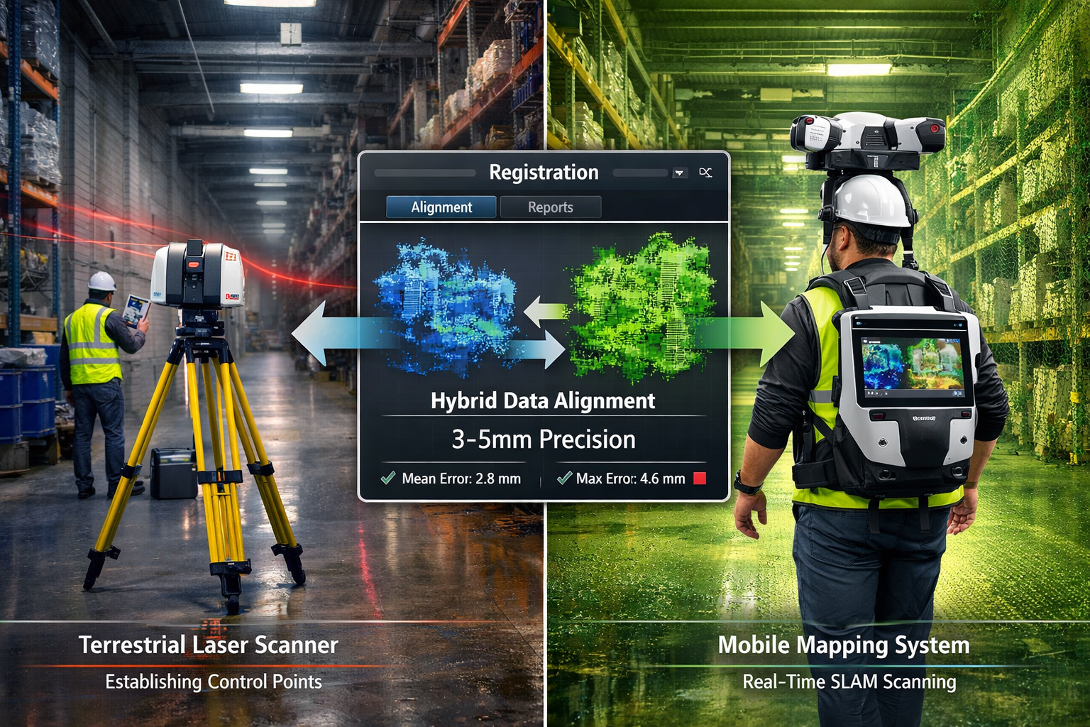
The Evolution to Hybrid Scanning Workflows
The debate between static and mobile scanning methodologies has reached a definitive conclusion in 2026. Rather than choosing one approach over the other, leading surveying firms now implement hybrid workflows that leverage the strengths of both technologies[2].
This "precision backbone" methodology works as follows:
- Control Network Establishment: Static TLS instruments capture high-accuracy reference scans at strategic locations throughout the site
- Rapid Volumetric Capture: Mobile SLAM devices fill the gaps between control points, capturing comprehensive interior and exterior data
- Automated Registration: Software automatically aligns mobile trajectories to static control points, eliminating drift accumulation
- Quality Assurance: Operators validate alignment in real-time using confidence maps displayed on integrated screens
This approach has become the default standard for large-scale projects rather than experimental practice, delivering field time reductions of approximately 60% compared to pure terrestrial scanning while maintaining engineering-grade accuracy of 3–5 mm[2].
Wearable SLAM Hardware Advancements
The maturation of wearable SLAM technology represents one of the most significant developments in practical implementation. Flagship 2026 devices feature dual or quad LiDAR sensors capturing millions of points per second with dramatically reduced noise levels compared to earlier generations[2].
Key improvements include:
- ✅ Cleaner architectural detail definition for door frames, pipes, and complex geometries
- ✅ Integrated operator feedback through confidence maps alerting to feature-poor environments
- ✅ On-site pre-registration via Wi-Fi-enabled tablets for immediate quality validation
- ✅ Extended battery life supporting full-day operations without recharging
- ✅ Reduced operator fatigue through ergonomic design improvements
These advancements enable surveyors to capture comprehensive data in challenging environments—including underground facilities, dense forests, and multi-story buildings—where GPS-based methods fail entirely[4].
Practical Implementation: Integrating 3D Laser Scanning Into Survey Workflows
Step 1: Project Assessment and Technology Selection
Successful implementation begins with matching the appropriate scanning technology to project requirements. Not every property survey demands the same level of precision or data density.
Decision Framework:
| Project Type | Recommended Approach | Accuracy Target | Typical Applications |
|---|---|---|---|
| Small residential properties | Mobile SLAM only | ±10-15 mm | Renovation planning, as-built documentation |
| Commercial buildings | Hybrid workflow | ±3-5 mm | Facility management, building surveys |
| Large industrial sites | Hybrid + drone integration | ±5-10 mm | Infrastructure assessment, volumetric analysis |
| Complex terrain | Drone LiDAR + ground control | ±15-25 mm | Topographic surveys, environmental studies |
| Underground facilities | SLAM mapper only | ±10-20 mm | Utility mapping, tunnel documentation |
When conducting boundary surveys or projects requiring legal defensibility, higher accuracy standards typically necessitate terrestrial laser scanning with traditional survey-grade control points.
Step 2: Pre-Survey Planning and Site Preparation
Effective 3D Laser Scanning for Property Surveys: From Adoption Boom to Practical Implementation requires thorough preparation before equipment deployment:
Site Reconnaissance:
- Identify access constraints and safety hazards
- Determine optimal scanner positions for complete coverage
- Assess lighting conditions (particularly for photogrammetry integration)
- Plan power supply and data storage requirements
- Coordinate with property occupants for access scheduling
Target Placement:
- Position spherical or checkerboard targets at strategic locations
- Ensure targets are visible from multiple scan positions
- Document target coordinates using GNSS or total station
- Consider permanent control monuments for repeat surveys
Regulatory Compliance:
- Review applicable standards (ALTA/NSPS, local requirements)
- Verify deliverable specifications with clients
- Obtain necessary permits and permissions
- Document chain of custody for legal projects
The 2026 ALTA/NSPS Guidelines, which took effect on February 23, 2026, include updates to Table A Optional Items that affect commercial property surveys and deliverable specifications[8]. Understanding these requirements prevents costly rework.
Step 3: Field Data Collection Execution
Modern field collection emphasizes efficiency without compromising quality:
Hybrid Workflow Execution:
-
Establish Control Network (30-40% of field time)
- Set up terrestrial laser scanner at primary control positions
- Capture high-resolution scans with overlapping coverage
- Document environmental conditions affecting accuracy
- Verify target visibility and registration quality
-
Mobile SLAM Capture (40-50% of field time)
- Walk systematic routes ensuring complete coverage
- Monitor real-time confidence maps for data quality
- Revisit areas flagged as feature-poor or uncertain
- Capture supplementary photos for texture mapping
-
On-Site Validation (10-20% of field time)
- Pre-register scans using tablet-based software
- Visually inspect alignment quality and completeness
- Identify and rescan any gaps or problematic areas
- Document any deviations from planned coverage
This field-finish approach has become standard practice, drastically reducing the number of costly return visits that plagued earlier implementations[2]. Operators can confidently leave the site knowing data quality meets project requirements.
Step 4: Data Processing and Registration
Post-processing transforms raw point clouds into actionable deliverables:
Registration Workflow:
- Import scans into processing software (Leica Cyclone, FARO Scene, Trimble RealWorks)
- Automatically align mobile SLAM trajectories to static control points
- Refine registration using cloud-to-cloud algorithms
- Verify alignment accuracy through error reports
- Export unified point cloud in client-specified format
Modern photogrammetry platforms like 3Dsurvey support unified workflows combining diverse data sources—drones, LiDAR, GNSS, SLAM mappers, and even smartphone video through RTK Videogrammetry—enabling surveyors to work without ecosystem lock-in[4]. This flexibility proves invaluable when integrating data from multiple collection sessions or supplementing laser scanning with aerial imagery.
Step 5: Deliverable Creation and Client Communication
The final phase converts technical data into formats clients can use for decision-making:
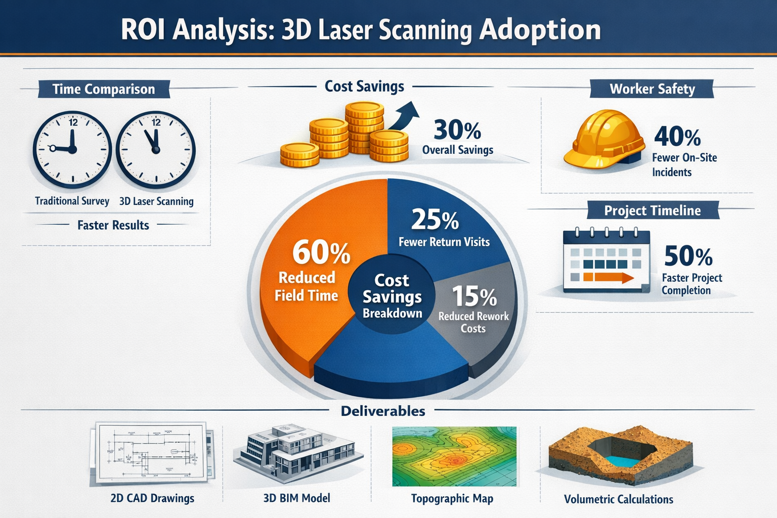
Standard Deliverables:
- 📐 2D CAD drawings extracted from point clouds (floor plans, elevations, sections)
- 🏗️ 3D BIM models for architectural and engineering coordination
- 🗺️ Topological maps showing elevation contours and terrain features
- 📊 Volumetric calculations for earthwork, storage capacity, or material quantities
- 💾 Registered point clouds in industry-standard formats (E57, LAS, RCP)
These outputs enable improved decision-making for construction, development, and environmental analysis[1][3]. When preparing deliverables for commercial building surveys, ensuring compatibility with client software systems prevents integration delays.
"Companies transitioning to 3D laser scanning report decreased overall costs through reduced manpower requirements, fewer field trips, fewer mistakes requiring rework, and enhanced worker safety during data collection."[1]
ROI Analysis: Justifying Investment in 3D Laser Scanning Technology
Capital Investment Requirements
Understanding the financial commitment necessary for 3D Laser Scanning for Property Surveys: From Adoption Boom to Practical Implementation helps firms make informed procurement decisions:
Equipment Costs (2026 Market Rates):
| Equipment Category | Price Range | Typical Lifespan | Annual Depreciation |
|---|---|---|---|
| Entry-level terrestrial scanner | £15,000-£35,000 | 5-7 years | £2,500-£7,000 |
| Professional TLS system | £40,000-£80,000 | 7-10 years | £4,000-£11,500 |
| Mobile SLAM backpack | £25,000-£60,000 | 3-5 years | £5,000-£20,000 |
| Drone LiDAR system | £30,000-£100,000 | 3-5 years | £6,000-£33,000 |
| Processing software (annual) | £2,000-£8,000 | Subscription | £2,000-£8,000 |
| Training and certification | £3,000-£10,000 | One-time | N/A |
Total Initial Investment: A firm implementing hybrid workflows typically invests £70,000-£150,000 in equipment, software, and training.
Operational Cost Reductions
The return on investment manifests through multiple operational improvements:
1. Reduced Field Time (60% Average Reduction)
Traditional survey methods for a 5,000 m² commercial building might require:
- 3-4 surveyors working 5-7 days
- Total labor cost: £8,000-£12,000
Hybrid laser scanning approach:
- 2 surveyors working 2-3 days
- Total labor cost: £3,200-£5,400
- Savings: £4,800-£6,600 per project
2. Fewer Return Visits (Estimated 75% Reduction)
Traditional surveys average 1.5 return visits per project for clarification or missing measurements:
- Cost per return: £800-£1,500
- Annual cost (20 projects): £24,000-£45,000
Laser scanning with field-finish validation:
- Return visits reduced to 0.4 per project
- Annual cost (20 projects): £6,400-£12,000
- Savings: £17,600-£33,000 annually
3. Reduced Rework and Errors (Estimated 40% Reduction)
Measurement errors requiring office rework or field verification:
- Traditional annual cost: £15,000-£25,000
- Laser scanning annual cost: £9,000-£15,000
- Savings: £6,000-£10,000 annually
4. Enhanced Worker Safety
Reducing time spent in hazardous environments (traffic, heights, unstable structures) lowers:
- Insurance premiums
- Lost-time incidents
- Liability exposure
While difficult to quantify precisely, safety improvements contribute significantly to long-term financial performance.
Revenue Enhancement Opportunities
Beyond cost reduction, laser scanning enables new service offerings:
- 🏢 Facility management documentation and maintenance planning
- 🔄 Repeat monitoring services for deformation analysis
- 🎨 Virtual tours and marketing materials for real estate
- 📈 As-built verification for construction quality assurance
- 🌍 Environmental compliance monitoring and reporting
Firms offering these specialized services typically command 15-30% premium pricing compared to traditional survey deliverables.
Break-Even Timeline
Conservative ROI Scenario:
- Initial investment: £100,000
- Annual cost savings: £30,000
- Annual revenue increase: £20,000
- Break-even: 2.0 years
Optimistic ROI Scenario:
- Initial investment: £100,000
- Annual cost savings: £50,000
- Annual revenue increase: £40,000
- Break-even: 1.1 years
Most firms implementing comprehensive 3D laser scanning programs achieve break-even within 18-30 months, with substantial ongoing benefits thereafter[1].
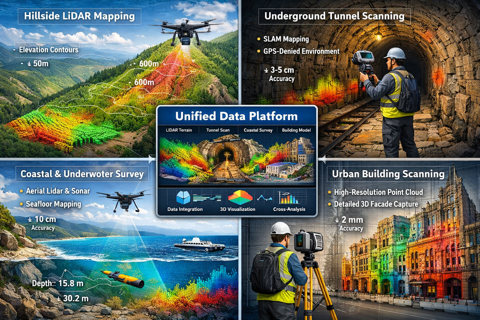
Advanced Applications: 3D Laser Scanning for Complex Terrain and Challenging Environments
Steep Terrain and Inaccessible Areas
Traditional surveying methods struggle with steep hillsides, cliff faces, and other terrain where physical access proves dangerous or impossible. Modern solutions combine autonomous drone swarms with terrestrial laser scanning to capture comprehensive elevation data with minimal human intervention[3].
Implementation Approach:
- Deploy drone LiDAR for aerial coverage of inaccessible slopes
- Establish ground control points in accessible perimeter areas
- Use terrestrial scanning for detailed features requiring higher accuracy
- Integrate datasets through photogrammetry software supporting multi-source workflows[4]
This methodology proves particularly valuable for:
- Infrastructure projects in mountainous regions
- Coastal erosion monitoring
- Quarry and mining operations
- Landslide risk assessment
Underground and GPS-Denied Environments
SLAM mappers have revolutionized surveying in environments where GPS signals are unavailable or unreliable:
Underground Applications:
- Utility tunnel mapping and maintenance
- Mine shaft documentation
- Underground parking facilities
- Subway and rail infrastructure
Indoor Complex Environments:
- Multi-story buildings with limited sight lines
- Dense industrial facilities with equipment obstruction
- Historic structures with intricate architectural details
- Warehouses and distribution centers
The ability to capture accurate spatial data without external positioning references represents a fundamental capability shift that opens previously impractical projects to systematic documentation[4].
Underwater and Coastal Zone Integration
Emerging workflows combine aerial LiDAR with sonar data integration for comprehensive coastal zone mapping:
- Bathymetric surveys of shallow coastal waters
- Dam and reservoir infrastructure assessment
- Lakebed topography for environmental studies
- Shoreline erosion monitoring
Modern photogrammetry platforms support this multi-source integration, enabling surveyors to deliver seamless datasets spanning the land-water interface[4]. This capability proves essential for drainage surveys and flood risk assessment projects.
Heritage and Conservation Documentation
3D laser scanning excels at capturing intricate architectural details for historic preservation:
Applications:
- Detailed as-built documentation before renovation
- Monitoring structural movement and deterioration
- Creating digital archives for cultural preservation
- Supporting restoration planning and grant applications
The non-contact nature of laser scanning prevents damage to fragile surfaces while capturing detail impossible to measure manually. When conducting Level 3 building surveys on historic properties, laser scanning provides comprehensive documentation supporting conservation decisions.
Regulatory Compliance and Professional Standards
ALTA/NSPS Land Title Survey Standards
The 2026 ALTA/NSPS Guidelines (11th edition), effective February 23, 2026, establish requirements for commercial real estate surveys in the United States[8]. Key provisions affecting laser scanning implementation include:
Table A Optional Items Updates:
- Specifications for 3D building models and point cloud deliverables
- Requirements for vertical accuracy in multi-story structures
- Standards for underground utility documentation
- Digital deliverable format specifications
Surveyors working on commercial transactions must understand these requirements to ensure laser scanning workflows produce compliant deliverables.
RICS Professional Standards
The Royal Institution of Chartered Surveyors (RICS) provides guidance for laser scanning implementation in the UK and internationally:
- Accuracy standards appropriate to survey purpose
- Competency requirements for operators and processors
- Quality assurance procedures and documentation
- Professional indemnity insurance considerations
When providing RICS building surveys or RICS valuations, ensuring laser scanning methodologies align with professional standards maintains credibility and reduces liability exposure.
Data Security and Privacy Considerations
3D laser scanning captures comprehensive spatial information that may include sensitive details:
Privacy Concerns:
- Inadvertent capture of personal information or activities
- Security implications of detailed infrastructure documentation
- Data retention and disposal requirements
- Third-party access controls
Best Practices:
- Obtain explicit permission before scanning private property
- Implement secure data storage and transmission protocols
- Redact sensitive information from deliverables
- Maintain clear data ownership and usage agreements
These considerations prove particularly important when conducting stock condition surveys of occupied residential buildings or sensitive commercial facilities.
Future Trends and Emerging Technologies
Artificial Intelligence and Automated Feature Extraction
Machine learning algorithms increasingly automate the extraction of features from point clouds:
- Automated classification of building components, vegetation, and terrain
- Object recognition for doors, windows, pipes, and structural elements
- Defect detection identifying cracks, deformation, and damage
- Change detection comparing temporal datasets for monitoring applications
These capabilities reduce processing time while improving consistency and reducing human error.
Real-Time Collaborative Workflows
Cloud-based platforms enable stakeholders to access and interact with scan data simultaneously:
- Architects reviewing as-built conditions during design
- Contractors verifying dimensional compliance during construction
- Facility managers accessing historical documentation for maintenance
- Clients approving deliverables before final processing
This collaborative approach improves project coordination and accelerates decision-making cycles.
Integration with Digital Twin Platforms
3D laser scanning provides the foundational spatial data for digital twin implementations:
- Continuous monitoring through periodic rescanning
- Integration with IoT sensors for real-time condition tracking
- Predictive maintenance based on deformation trends
- Energy modeling and optimization
As digital twin adoption accelerates across industries, laser scanning becomes an essential enabling technology rather than a standalone service.
Miniaturization and Cost Reduction
Ongoing technological advancement continues to reduce equipment costs and size:
- Smartphone-based LiDAR for basic documentation
- Lightweight handheld scanners for small projects
- Improved battery technology extending field operation time
- Simplified software interfaces reducing training requirements
These trends expand access to laser scanning technology for smaller firms and routine applications.
Overcoming Implementation Challenges
Staff Training and Skill Development
Successful adoption requires investment in human capital alongside equipment:
Training Priorities:
- Equipment operation and field procedures
- Registration software proficiency
- CAD and BIM modeling from point clouds
- Quality control and accuracy verification
- Client communication and deliverable presentation
Many equipment manufacturers offer certification programs, while professional organizations provide continuing education opportunities. Allocating 2-4 weeks for initial training and ongoing skill development ensures staff can fully utilize technology capabilities.
Managing Client Expectations
Educating clients about laser scanning capabilities and limitations prevents misunderstandings:
Common Misconceptions:
- "Laser scanning captures everything automatically" (requires skilled planning)
- "Point clouds are immediately usable" (processing and modeling required)
- "Laser scanning eliminates all traditional surveying" (complementary, not replacement)
- "Higher point density always means better results" (appropriate density varies by application)
Clear communication about deliverable formats, accuracy specifications, and project timelines establishes realistic expectations and prevents disputes.
Data Management Infrastructure
Point cloud datasets generate substantial data volumes requiring robust infrastructure:
Storage Requirements:
- Typical project: 50-500 GB raw data
- Annual portfolio: 2-10 TB storage capacity
- Backup and redundancy systems
- Long-term archival for repeat surveys
Processing Capacity:
- High-performance workstations with dedicated GPUs
- Sufficient RAM (32-64 GB minimum)
- Fast SSD storage for active projects
- Network infrastructure for collaborative workflows
Budgeting for these infrastructure requirements prevents bottlenecks that undermine field efficiency gains.
Quality Assurance Protocols
Implementing systematic quality control maintains accuracy and consistency:
Field QA:
- Pre-deployment equipment calibration
- Real-time registration verification
- Redundant coverage of critical areas
- Environmental condition documentation
Office QA:
- Registration accuracy reports
- Comparison with independent check measurements
- Peer review of deliverables
- Client feedback incorporation
These protocols ensure laser scanning projects meet professional standards comparable to traditional surveying methods.
Case Studies: Real-World Implementation Success
Case Study 1: Large Commercial Development
Project: 15,000 m² mixed-use development requiring comprehensive as-built documentation
Traditional Approach Estimate:
- 4 surveyors × 12 days = 48 person-days
- 3 return visits for clarifications
- Total cost: £24,000
- Timeline: 4 weeks
Hybrid Laser Scanning Implementation:
- 2 surveyors × 5 days = 10 person-days
- Zero return visits (field-finish validation)
- Total cost: £9,600
- Timeline: 1.5 weeks
Results:
- 60% cost reduction
- 63% timeline reduction
- Enhanced deliverables including 3D BIM model
- Client satisfaction enabling repeat business
This project exemplifies the practical implementation benefits achievable through systematic hybrid workflow adoption.
Case Study 2: Historic Building Conservation
Project: Detailed documentation of Grade II listed building before renovation
Challenges:
- Intricate architectural details requiring high accuracy
- Fragile surfaces preventing contact measurement
- Tight timeline for grant application support
Solution:
- Terrestrial laser scanning for exterior facades (2 mm accuracy)
- Mobile SLAM for interior spaces and complex geometries
- Photogrammetry for texture mapping and visualization
- Automated feature extraction for architectural elements
Deliverables:
- Comprehensive point cloud archive
- Detailed 2D drawings for planning applications
- 3D model for renovation design coordination
- Virtual tour for stakeholder engagement
The non-invasive nature of laser scanning proved essential for this sensitive heritage application, demonstrating capabilities beyond traditional surveying methods.
Case Study 3: Infrastructure Monitoring Program
Project: Quarterly deformation monitoring of aging bridge structure
Traditional Approach:
- Manual measurements at predetermined monitoring points
- Limited spatial coverage
- Labor-intensive repeat surveys
- Difficulty detecting unexpected movement patterns
Laser Scanning Solution:
- Baseline terrestrial scan establishing reference geometry
- Quarterly rescans using identical scanner positions
- Automated change detection comparing temporal datasets
- Comprehensive coverage identifying localized deformation
Results:
- Early detection of support settlement requiring intervention
- Prevented potential structural failure
- Documented compliance with safety regulations
- Cost-effective long-term monitoring program
This application showcases laser scanning's value for ongoing monitoring and risk management beyond one-time documentation projects.
Conclusion: Actionable Steps for Successful Adoption
The journey from 3D Laser Scanning for Property Surveys: From Adoption Boom to Practical Implementation requires strategic planning, systematic execution, and ongoing refinement. The technology has matured beyond experimental status to become an essential capability for competitive surveying practices in 2026.
Immediate Action Steps
For Firms Beginning Adoption:
- Assess current project portfolio to identify high-value applications where laser scanning delivers immediate ROI
- Start with rental equipment to gain experience before capital investment
- Invest in comprehensive training for at least two staff members to build internal expertise
- Partner with experienced providers for initial projects to accelerate learning
- Document workflows and lessons learned to refine procedures systematically
For Firms Expanding Capabilities:
- Implement hybrid workflows combining terrestrial and mobile technologies
- Adopt field-finish validation protocols to eliminate costly return visits
- Explore multi-source integration incorporating drone and photogrammetry data
- Develop specialized service offerings leveraging unique laser scanning capabilities
- Invest in collaborative platforms enabling real-time stakeholder engagement
For All Practitioners:
- Stay current with regulatory updates including ALTA/NSPS standards and RICS guidance
- Participate in professional development through industry conferences and certification programs
- Build client education into project proposals and deliverable presentations
- Maintain quality assurance protocols ensuring consistent accuracy and reliability
- Monitor emerging technologies including AI-powered feature extraction and digital twin integration
The Path Forward
The adoption boom has conclusively demonstrated that 3D laser scanning delivers measurable value across diverse applications—from routine property surveys to complex infrastructure monitoring. The challenge now lies not in proving the technology's worth, but in implementing it effectively to capture available benefits.
Firms that approach adoption strategically—matching technology to application, investing in training, refining workflows, and maintaining quality standards—position themselves to thrive in an increasingly competitive market. Those that delay risk falling behind competitors who leverage laser scanning's speed, accuracy, and comprehensive documentation capabilities.
The future of property surveying integrates traditional expertise with advanced technology. Success requires embracing both elements: the professional judgment and regulatory knowledge that define quality surveying practice, combined with the technological capabilities that enable unprecedented efficiency and insight.
The adoption boom has arrived. The practical implementation phase is now.
Whether conducting boundary surveys, building surveys, or specialized applications, 3D laser scanning provides tools to deliver superior results more efficiently than ever before. The question is no longer whether to adopt laser scanning, but how quickly and effectively your practice can implement it.
For guidance on integrating laser scanning into your specific surveying needs, contact experienced professionals who can provide tailored recommendations based on your project requirements and business objectives.
References
[1] 3d Laser Scanning Used In Land Surveying – https://www.duncan-parnell.com/blog/108/3d-laser-scanning-used-in-land-surveying
[2] 3d Laser Scanning In 2026 Major Technology And Workflow Shifts – https://www.enginyring.com/en/blog/3d-laser-scanning-in-2026-major-technology-and-workflow-shifts
[3] How Technology Is Revolutionizing Land Surveys – https://www.firstchoicesurveying.com/blog/how-technology-is-revolutionizing-land-surveys
[4] 3dsurvey Is The Best Photogrammetry Software In 2026 – https://3dsurvey.si/3dsurvey-is-the-best-photogrammetry-software-in-2026/
[8] What 2026 Alta Nsps Updates Mean For Cre Professionals – https://www.partneresi.com/resources/articles/what-2026-alta-nsps-updates-mean-for-cre-professionals/