
The property development landscape in 2026 has transformed dramatically, with surveyors no longer relying solely on traditional measurement tools and paper maps. Geographic Information Systems (GIS) have become the cornerstone of modern surveying practice, fundamentally changing how professionals analyze land, make decisions, and communicate findings to stakeholders. GIS Mastery for Surveyors: Enhancing Data Analysis and Decision-Making in Property Development represents more than just technical skill—it's a competitive advantage that separates forward-thinking professionals from those struggling to keep pace with industry demands.
As digital transformation accelerates across the surveying profession, mastering GIS technology has become essential for delivering the faster, more accurate results that clients expect [3]. This comprehensive guide explores how surveyors can leverage GIS to organize geospatial data, identify critical land use trends, and create compelling visualizations that drive better planning outcomes across diverse property development scenarios.
Key Takeaways
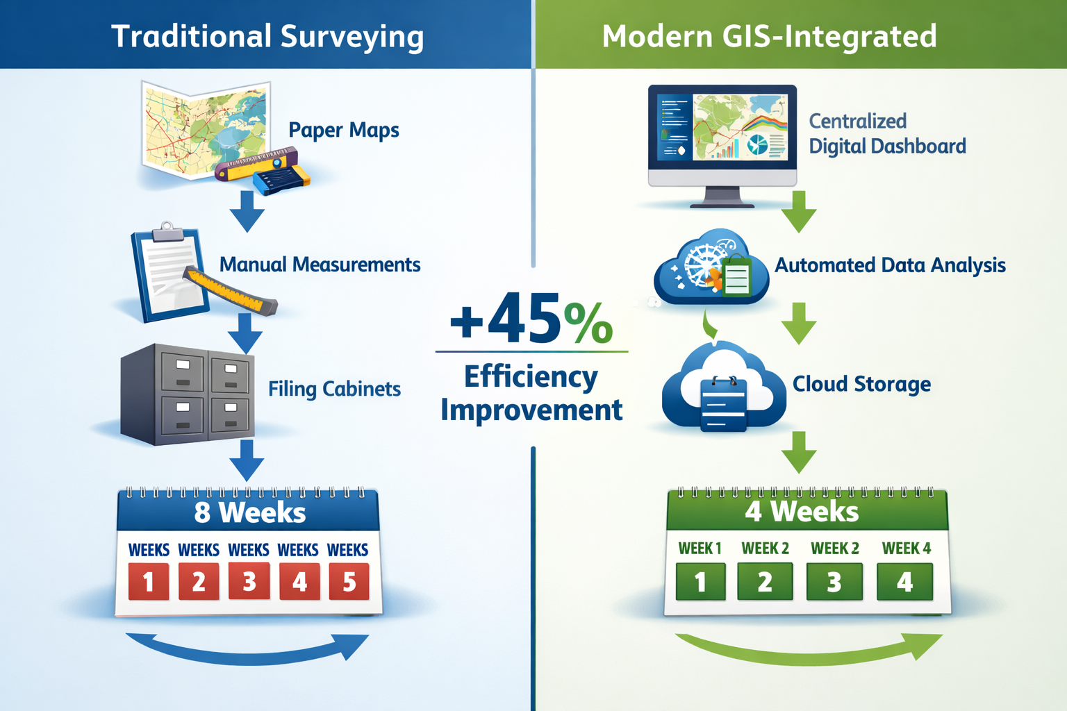
- GIS integration reduces traditional surveying timelines by 40-50% through centralized data management and the ability to overlay multiple datasets in a single map [7]
- Professionals with GIS skills command a 10-15% earnings premium while opening doors to consulting opportunities and leadership roles in real estate analysis [4]
- 3D GIS technology powered by AI and real-time spatial insights enables comprehensive asset lifecycle management far beyond traditional project boundaries [3]
- Interactive GIS visualizations strengthen stakeholder communication by showing developers and decision-makers how proposed changes affect housing, transportation, and infrastructure needs [2]
- Data-driven spatial analysis identifies development opportunities by mapping zoning capacity, infrastructure constraints, and preservation requirements on a single shared platform [2]
Understanding GIS Fundamentals for Modern Surveying Practice
What Makes GIS Essential for Property Development Surveyors?
Geographic Information Systems represent a powerful framework for capturing, storing, analyzing, and displaying spatial data related to positions on Earth's surface. For surveyors working in property development, GIS transforms raw measurement data into actionable intelligence that drives investment decisions worth millions of pounds.
The core capabilities that make GIS indispensable include:
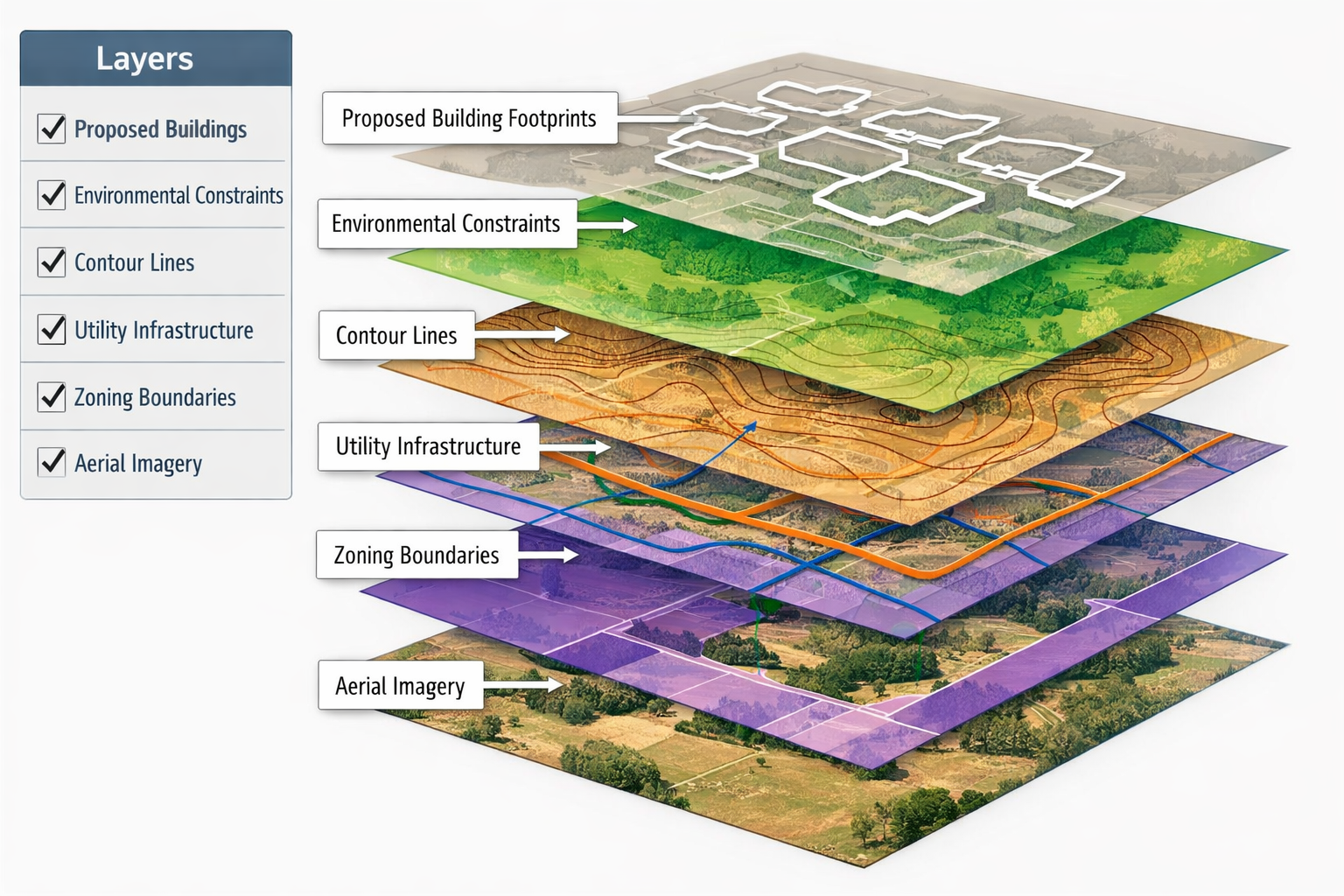
- 📊 Multi-layer data visualization – Overlaying property boundaries, topography, utilities, zoning regulations, and environmental constraints
- 🔍 Spatial analysis tools – Identifying patterns, relationships, and trends invisible in traditional survey reports
- 🗺️ Interactive mapping – Creating dynamic visualizations that stakeholders can explore and understand
- 📱 Mobile data collection – Capturing field observations that automatically sync with centralized databases
- 🔄 Real-time collaboration – Sharing updated information across project teams instantly
The surveying profession is entering 2026 amid accelerating digital transformation, driven by pressure to deliver faster, more accurate results that feed comprehensive asset lifecycle management systems [3]. This shift means that understanding different types of surveyors and their specialized GIS applications has become increasingly important.
The Evolution of GIS Technology in Surveying
GIS technology has evolved from simple digital mapping systems to sophisticated platforms incorporating artificial intelligence, machine learning, and real-time data processing. The evolution of GIS mapping in 2026 reflects several transformative trends that directly impact surveying practice [8]:
Traditional GIS (2000-2015):
- Static map production
- Desktop-only software
- Manual data entry
- Limited analysis capabilities
Modern GIS (2016-2025):
- Cloud-based platforms
- Mobile integration
- Automated data capture
- Advanced spatial analytics
Next-Generation GIS (2026 and beyond):
- AI-powered insights
- 3D modeling and visualization
- Real-time sensor integration
- Predictive analytics
- Augmented reality overlays
This technological progression has fundamentally changed what surveyors can accomplish. 3D GIS technology is being redefined by AI and real-time spatial insights, enabling asset lifecycle management far beyond traditional project boundaries [3].
GIS Mastery for Surveyors: Core Competencies and Technical Skills
Essential GIS Software Platforms for Surveyors
Developing GIS Mastery for Surveyors: Enhancing Data Analysis and Decision-Making in Property Development requires proficiency with industry-standard software platforms. Each platform offers unique capabilities suited to different aspects of property development work.
| Platform | Primary Strengths | Best Use Cases | Learning Curve |
|---|---|---|---|
| ArcGIS Pro | Comprehensive analysis tools, 3D visualization, enterprise integration | Large-scale development projects, municipal planning, infrastructure analysis | Moderate to High |
| QGIS | Open-source flexibility, cost-effectiveness, plugin ecosystem | Small to medium projects, budget-conscious firms, custom workflows | Moderate |
| AutoCAD Map 3D | CAD integration, engineering design, survey data management | Engineering surveys, utility mapping, design coordination | Moderate |
| Global Mapper | Terrain analysis, LiDAR processing, format conversion | Topographic surveys, elevation modeling, data preparation | Low to Moderate |
| MapInfo Pro | Business intelligence, location analytics, demographic analysis | Market research, site selection, feasibility studies | Low to Moderate |
The choice of platform often depends on project requirements, client specifications, and existing organizational infrastructure. Many successful surveying practices develop expertise in multiple platforms to serve diverse client needs effectively.
Data Collection and Integration Techniques
Modern GIS mastery extends beyond software proficiency to encompass sophisticated data collection methodologies. 360° imagery has become a standard data collection component across asset management, cadastral mapping, and surveying, accelerating decision-making by providing context difficult to obtain from LiDAR or aerial imagery alone [5].
Key data collection methods for property development surveys:
- Total Station Integration – Direct import of survey measurements into GIS databases
- GPS/GNSS Positioning – High-accuracy location data for boundary and topographic surveys
- Drone Photogrammetry – Aerial imagery processed into orthophotos and 3D models
- LiDAR Scanning – Detailed elevation data and point clouds for terrain modeling
- Mobile Mapping – Street-level imagery and measurements for urban environments
- Existing Records Digitization – Converting historical maps and documents into GIS layers
The integration of these diverse data sources creates comprehensive spatial databases that support sophisticated analysis. When conducting comprehensive condition survey reports, surveyors can overlay building conditions with historical data, environmental factors, and neighborhood trends to provide deeper insights.
Spatial Analysis Fundamentals
Spatial analysis represents the analytical heart of GIS mastery, transforming raw data into actionable insights for property development decisions. Understanding these fundamental analysis techniques separates competent GIS users from true masters:
🔹 Proximity Analysis
Determining distances and relationships between features—essential for assessing accessibility to transportation, amenities, and services that impact property values.
🔹 Overlay Analysis
Combining multiple data layers to identify areas meeting specific criteria, such as developable land with appropriate zoning, adequate infrastructure, and minimal environmental constraints.
🔹 Network Analysis
Evaluating connectivity and accessibility through transportation networks, utility systems, and pedestrian pathways.
🔹 Terrain Analysis
Calculating slope, aspect, viewsheds, and drainage patterns that affect development feasibility and design requirements.
🔹 Density Analysis
Identifying clustering patterns in development, demographics, or infrastructure that reveal market opportunities or constraints.
These analytical capabilities enable surveyors to answer complex questions that drive development decisions: Which parcels offer the best development potential? How will proposed changes affect traffic patterns? Where should infrastructure investments be prioritized?
Enhancing Data Analysis Through Advanced GIS Applications
Property Boundary and Cadastral Mapping
Accurate property boundary determination forms the foundation of all development projects. GIS technology has revolutionized cadastral surveying by enabling surveyors to maintain comprehensive parcel databases that integrate legal descriptions, historical surveys, and current measurements.
Advanced GIS applications in boundary surveying include:
- Historical deed research visualization – Mapping property descriptions from historical documents
- Boundary conflict identification – Detecting overlaps, gaps, and inconsistencies in parcel records
- Easement and right-of-way mapping – Documenting access rights and restrictions
- Subdivision planning – Designing lot configurations that maximize value while meeting regulations
- Title insurance support – Providing visual documentation for underwriting decisions
GIS integration reduces traditional surveying timelines by 40-50% through centralized data management, allowing surveyors to overlay multiple datasets—including zoning information, boundaries, and utility locations—in a single map [7]. This efficiency gain directly translates to competitive advantages in winning and executing projects.
For professionals wondering whether they need a survey when buying a house, GIS-enhanced boundary surveys provide unprecedented clarity about property extents and potential issues.
Zoning and Land Use Analysis
Understanding zoning regulations and land use patterns represents a critical component of GIS Mastery for Surveyors: Enhancing Data Analysis and Decision-Making in Property Development. GIS enables data-driven spatial analysis for identifying development opportunities, allowing planners to map zoning capacity, infrastructure constraints, permitting backlogs, and preservation opportunities on a single shared canvas [2].
Practical GIS applications for zoning analysis:
✅ Zoning compliance verification – Confirming proposed developments meet setback, height, and density requirements
✅ Variance opportunity identification – Analyzing where zoning modifications might be justified and achievable
✅ Future land use forecasting – Modeling how comprehensive plan changes might affect development patterns
✅ Mixed-use development planning – Optimizing combinations of residential, commercial, and recreational uses
✅ Overlay district mapping – Tracking additional regulations like historic preservation or environmental protection zones
Real estate consultants leverage GIS to identify market opportunities and assess property values by analyzing demographic trends and purchasing power, mapping competition and market saturation, evaluating location factors, and identifying emerging neighborhood development patterns [4].
Infrastructure and Utility Analysis
Property development success depends heavily on adequate infrastructure capacity. GIS provides surveyors with powerful tools for analyzing existing utilities and planning new infrastructure to support development.
Critical infrastructure analysis capabilities:
| Infrastructure Type | GIS Analysis Applications | Development Impact |
|---|---|---|
| Water/Sewer | Capacity modeling, connection feasibility, service area mapping | Determines development density, phasing requirements |
| Electrical | Load analysis, substation proximity, easement routing | Affects construction costs, timeline |
| Transportation | Traffic impact modeling, access analysis, transit proximity | Influences project approvals, market appeal |
| Telecommunications | Broadband availability, fiber routing, coverage gaps | Impacts commercial viability, residential demand |
| Stormwater | Drainage analysis, detention requirements, flood zones | Drives site design, regulatory compliance |
When conducting drainage surveys, GIS integration allows surveyors to model watershed boundaries, calculate runoff volumes, and design stormwater management systems that meet regulatory requirements while minimizing costs.
Environmental Constraint Mapping
Environmental considerations increasingly shape development feasibility and design. GIS excels at identifying and visualizing environmental constraints that affect property development decisions.
Key environmental factors mapped through GIS:
🌳 Protected habitats and species – Wetlands, endangered species locations, migration corridors
🏞️ Topographic constraints – Steep slopes, unstable soils, erosion-prone areas
💧 Water resources – Floodplains, watersheds, groundwater recharge areas
🏛️ Cultural resources – Archaeological sites, historic structures, cultural landscapes
☣️ Contamination concerns – Brownfield sites, underground storage tanks, industrial legacy issues
Remote sensing and data analytics innovations improve land acquisition decision-making by helping investors assess land value and potential more accurately while reducing risks associated with property acquisitions [1]. This capability proves particularly valuable when evaluating sites with complex environmental histories.
Decision-Making Enhancement Through GIS Visualization and Communication
Creating Compelling Visual Presentations for Stakeholders
One of the most powerful aspects of GIS Mastery for Surveyors: Enhancing Data Analysis and Decision-Making in Property Development lies in the ability to communicate complex spatial information clearly to non-technical audiences. GIS visualization capabilities strengthen municipal planning communication, with interactive scenario mapping showing developers, decision-makers, and residents how proposed changes might affect housing affordability, jobs, transportation performance, and capital needs [2].
Effective GIS visualization techniques include:
📊 Before/after comparisons – Showing existing conditions versus proposed development impacts
🗺️ Interactive web maps – Allowing stakeholders to explore data layers relevant to their interests
📈 Infographic-style maps – Combining cartography with charts and statistics for comprehensive storytelling
🎥 Animated flythrough – Demonstrating 3D development scenarios from multiple perspectives
📱 Mobile-friendly dashboards – Providing real-time project information accessible anywhere
When preparing presentations for planning commissions, investors, or community meetings, surveyors who master these visualization techniques dramatically increase their influence on decision outcomes. The ability to show rather than merely describe development impacts creates understanding that drives consensus.
Scenario Planning and Impact Assessment
GIS enables sophisticated scenario planning that helps stakeholders understand trade-offs between different development approaches. This capability proves invaluable when navigating complex projects with multiple competing objectives.
Scenario planning applications:
- Density alternatives – Comparing low, medium, and high-density development options
- Phasing strategies – Modeling different construction sequences and their infrastructure implications
- Design variations – Evaluating architectural approaches and their site impacts
- Mixed-use configurations – Testing different combinations of residential, commercial, and civic uses
- Infrastructure investment priorities – Assessing which improvements deliver the greatest development enablement
"GIS serves as the backbone of municipal planning systems, with city and county leaders increasingly using Geographic Information Systems to connect data, people, and decisions—particularly critical given mounting pressures on housing, resilience, and compliance with limited staff and budgets." [2]
This scenario planning capability becomes particularly valuable when working with chartered surveyors on complex urban development projects where multiple stakeholder interests must be balanced.
Real-Time Collaboration and Cloud-Based Workflows
Modern GIS platforms enable real-time collaboration that transforms how surveying teams work together and share information with clients. Cloud-based workflows eliminate the version control problems and communication delays that plagued traditional surveying practice.
Benefits of cloud-based GIS collaboration:
✨ Simultaneous editing – Multiple team members updating different aspects of the same project
✨ Automatic synchronization – Field data instantly available to office staff for analysis
✨ Client portals – Secure access for stakeholders to view project progress without software installation
✨ Mobile accessibility – Full GIS capabilities available on tablets and smartphones in the field
✨ Reduced IT overhead – No need for expensive server infrastructure or software maintenance
System flexibility is becoming a core selection criterion for organizations designing processes to handle greater complexity and longevity, reflecting industry-wide trends rather than hardware or software-specific requirements [5].
Data-Driven Market Analysis for Investment Decisions
Surveyors with GIS mastery can provide clients with sophisticated market analysis that goes far beyond traditional property descriptions. By integrating demographic data, economic indicators, and competitive intelligence, GIS transforms surveyors into strategic advisors for development investments.
Market analysis capabilities through GIS:
- Demographic profiling – Understanding population characteristics, income levels, and household composition
- Trade area analysis – Defining market catchment areas for retail and commercial developments
- Competitor mapping – Identifying existing developments and assessing market saturation
- Growth trend visualization – Tracking historical development patterns to forecast future opportunities
- Accessibility scoring – Quantifying location advantages based on transportation and amenity proximity
GIS skills command a 10-15% earnings premium for urban professionals, while opening doors to consulting opportunities and leadership roles in real estate analysis and planning decisions [4]. This premium reflects the substantial value that data-driven insights bring to development decision-making.
Practical Implementation: Building Your GIS Mastery Roadmap
Learning Pathways and Professional Development
Developing GIS Mastery for Surveyors: Enhancing Data Analysis and Decision-Making in Property Development requires a structured approach to skill acquisition. The learning pathway varies based on existing technical background and specific career objectives.
Recommended learning progression:
Phase 1: Foundations (3-6 months)
- Basic GIS concepts and terminology
- Introduction to coordinate systems and projections
- Simple data visualization and map creation
- Fundamental spatial analysis techniques
Phase 2: Intermediate Skills (6-12 months)
- Advanced spatial analysis methods
- Database design and management
- Custom symbology and cartographic design
- Integration with surveying instruments
Phase 3: Advanced Applications (12-24 months)
- 3D modeling and visualization
- Python scripting for automation
- Web GIS and mobile applications
- Custom tool development
Phase 4: Mastery and Specialization (Ongoing)
- AI and machine learning integration
- Industry-specific advanced applications
- Thought leadership and innovation
- Training and mentoring others
Professional certifications such as the Esri Technical Certification or GISP (GIS Professional) credential demonstrate competency to clients and employers. When evaluating whether a surveyor is qualified, GIS certifications increasingly appear alongside traditional surveying credentials.
Essential Tools and Software Ecosystem
Building a comprehensive GIS toolkit requires understanding not just primary platforms but the entire ecosystem of complementary tools that enhance productivity.
Core GIS software stack for surveyors:
🔧 Primary GIS Platform – ArcGIS Pro, QGIS, or equivalent for main analysis and mapping
🔧 CAD Integration – AutoCAD, MicroStation, or Civil 3D for engineering coordination
🔧 Data Processing – Global Mapper, FME, or custom Python scripts for format conversion
🔧 Field Collection – Survey123, Collector, or QField for mobile data capture
🔧 Visualization – ArcGIS Online, Mapbox, or Leaflet for web mapping
🔧 Database Management – PostgreSQL/PostGIS, SQL Server, or Oracle Spatial for data storage
🔧 Analysis Extensions – Spatial Analyst, 3D Analyst, Network Analyst for specialized functions
The specific combination depends on project types, client requirements, and budget constraints. Many successful practices start with open-source solutions like QGIS and gradually add commercial tools as specific needs arise.
Integrating GIS with Traditional Surveying Workflows
The transition from traditional surveying methods to GIS-enhanced workflows requires careful planning to maintain productivity during the learning curve. Successful integration follows a phased approach that builds confidence while delivering immediate value.
Integration strategy:
Step 1: Data Centralization
Establish a central GIS database for all survey projects, even if initial analysis remains traditional. This creates a foundation for future capabilities.
Step 2: Visualization Enhancement
Begin producing GIS-based maps and visualizations for client deliverables while maintaining existing analysis methods.
Step 3: Analysis Integration
Gradually incorporate GIS spatial analysis tools into decision-making processes, starting with simple proximity and overlay operations.
Step 4: Workflow Automation
Develop automated processes for routine tasks, freeing time for complex analysis and client consultation.
Step 5: Advanced Applications
Expand into 3D modeling, predictive analytics, and other sophisticated capabilities that differentiate services.
When conducting Level 2 home surveys or Level 3 surveys, GIS integration allows surveyors to provide neighborhood context and comparative analysis that adds substantial value beyond traditional building assessments.
Data Quality and Accuracy Management
GIS analysis quality depends entirely on input data accuracy. Surveyors must implement rigorous quality control procedures to ensure GIS outputs meet professional standards and support reliable decision-making.
Critical data quality considerations:
✔️ Source documentation – Maintaining clear records of data origins, collection methods, and accuracy specifications
✔️ Metadata standards – Creating comprehensive descriptions of datasets including coordinate systems, accuracy, and limitations
✔️ Validation procedures – Implementing systematic checks for logical consistency, completeness, and accuracy
✔️ Version control – Tracking data updates and maintaining historical records of changes
✔️ Accuracy reporting – Clearly communicating uncertainty and limitations to clients and stakeholders
Professional surveyors understand that GIS technology amplifies both accuracy and errors. A small mistake in coordinate system definition or data entry can propagate through analysis to produce misleading results. Rigorous quality management prevents these issues.
Sector-Specific Applications and Case Studies
Residential Development Applications
GIS Mastery for Surveyors: Enhancing Data Analysis and Decision-Making in Property Development proves particularly valuable in residential development, where multiple factors influence site selection, design, and marketing.
Residential development GIS applications:
🏘️ Site selection analysis – Identifying parcels meeting size, zoning, and infrastructure requirements
🏘️ Neighborhood compatibility assessment – Evaluating how proposed development fits existing character
🏘️ School district mapping – Analyzing educational facility access that drives family purchasing decisions
🏘️ Amenity proximity scoring – Quantifying walkability to parks, shopping, and services
🏘️ View corridor analysis – Identifying lots with premium views that command higher prices
🏘️ Solar exposure modeling – Optimizing lot orientation for energy efficiency
When hiring a residential surveyor, clients increasingly expect GIS-enhanced analysis that goes beyond basic measurements to provide strategic development insights.
Commercial and Mixed-Use Development
Commercial development decisions involve complex trade-offs between location, accessibility, market demographics, and competition. GIS provides the analytical framework for optimizing these factors.
Commercial development GIS capabilities:
- Trade area delineation – Defining customer catchment areas based on drive times and demographics
- Traffic count integration – Mapping vehicle and pedestrian flows past potential sites
- Competitor analysis – Identifying existing businesses and assessing market saturation
- Visibility analysis – Calculating sight lines from major roads and intersections
- Parking demand modeling – Estimating requirements based on use mix and local regulations
- Tenant mix optimization – Planning retail configurations that maximize synergies
Real estate consultants leverage GIS to identify market opportunities and assess property values by analyzing demographic trends and purchasing power, mapping competition and market saturation, evaluating location factors, and identifying emerging neighborhood development patterns [4].
Infrastructure and Utility Development
Large-scale infrastructure projects benefit enormously from GIS capabilities for route optimization, impact assessment, and stakeholder communication. Surveyors working on these projects must master specialized GIS applications.
Infrastructure project GIS applications:
⚡ Corridor analysis – Identifying optimal routes balancing engineering, environmental, and property impacts
⚡ Right-of-way acquisition – Mapping parcels requiring easements or purchase
⚡ Impact zone modeling – Defining areas affected by construction activities
⚡ Utility conflict detection – Identifying existing infrastructure requiring relocation
⚡ Restoration planning – Documenting pre-construction conditions for post-project restoration
Community-driven innovation at the edges is accelerating geospatial technology adoption, with field practitioners adapting tools beyond original use cases, open ecosystems facilitating experimentation, and small developers pushing creative extensions [5].
Municipal Planning and Public Sector Applications
GIS serves as the backbone of municipal planning systems, with city and county leaders increasingly using Geographic Information Systems to connect data, people, and decisions [2]. Surveyors working with public sector clients must understand how GIS supports comprehensive planning processes.
Public sector GIS applications:
📋 Comprehensive plan implementation – Tracking development against long-term vision
📋 Capital improvement programming – Prioritizing infrastructure investments based on spatial needs
📋 Permit tracking and enforcement – Managing development applications and compliance
📋 Public engagement – Creating interactive maps for community input on planning decisions
📋 Performance metrics – Monitoring progress toward planning goals with spatial indicators
Understanding these public sector applications helps surveyors provide services that align with governmental decision-making processes and regulatory requirements.
Emerging Trends and Future Directions

Artificial Intelligence and Machine Learning Integration
The integration of AI and machine learning with GIS represents one of the most transformative trends shaping the future of surveying practice. These technologies automate complex analysis and reveal patterns invisible to traditional methods.
AI applications in GIS for surveyors:
🤖 Automated feature extraction – AI identifying buildings, roads, and land cover from imagery
🤖 Predictive modeling – Machine learning forecasting development patterns and property values
🤖 Anomaly detection – Algorithms identifying data errors or unusual conditions requiring investigation
🤖 Natural language queries – Conversational interfaces simplifying complex spatial analysis
🤖 Image classification – Automated categorization of land use from aerial and satellite imagery
3D GIS technology is being redefined by AI and real-time spatial insights, enabling asset lifecycle management far beyond traditional project boundaries, while supporting advanced modeling and spatial data capture for infrastructure asset management [3].
Real-Time Data Integration and IoT Sensors
The proliferation of Internet of Things (IoT) sensors creates opportunities for real-time monitoring and analysis that transforms how surveyors understand property conditions and development impacts.
IoT integration opportunities:
- Environmental monitoring – Real-time air quality, noise, and temperature data
- Traffic and pedestrian counting – Continuous flow measurements replacing periodic studies
- Structural monitoring – Sensors tracking settlement, vibration, and stress in buildings
- Utility consumption – Real-time water, energy, and telecommunications usage patterns
- Construction progress tracking – Automated documentation of building advancement
These real-time data streams enable surveyors to provide ongoing intelligence rather than static snapshots, creating new service opportunities and revenue models.
Augmented Reality and Field Visualization
Augmented reality (AR) technology overlays digital GIS information onto physical environments, transforming how surveyors work in the field and communicate with clients.
AR applications for surveyors:
👓 Underground utility visualization – Seeing buried infrastructure before excavation
👓 Proposed development preview – Viewing planned buildings in actual site context
👓 Boundary line display – Visualizing property lines overlaid on actual terrain
👓 As-built verification – Comparing constructed conditions to design specifications
👓 Safety zone identification – Highlighting hazardous areas or restricted zones
As AR technology becomes more accessible and user-friendly, surveyors who master these capabilities will deliver dramatically enhanced client experiences.
Sustainability and Climate Resilience Analysis
Growing emphasis on environmental sustainability and climate change adaptation drives demand for GIS analysis supporting resilient development decisions.
Sustainability-focused GIS applications:
🌍 Carbon footprint modeling – Calculating emissions from development and transportation patterns
🌍 Renewable energy potential – Analyzing solar and wind resource availability
🌍 Green infrastructure planning – Optimizing stormwater management and habitat connectivity
🌍 Climate risk assessment – Evaluating flood, heat, and storm vulnerability
🌍 Adaptation strategy development – Planning infrastructure modifications for changing conditions
Land investing trends in 2026 increasingly emphasize sustainability considerations, with remote sensing and data analytics innovations improving land acquisition decision-making [1].
Blockchain and Property Rights Management
Emerging blockchain technologies promise to revolutionize property rights documentation and transfer, with GIS playing a central role in spatial verification.
Potential blockchain-GIS integration:
- Immutable boundary records – Tamper-proof documentation of property extents
- Automated title transfer – Smart contracts executing based on spatial verification
- Transparent development rights – Clear tracking of zoning entitlements and transfers
- Decentralized cadastral systems – Community-maintained property databases
- International standardization – Cross-border property information exchange
While still emerging, these technologies may fundamentally change how surveyors document and verify property information in coming years.
Overcoming Implementation Challenges
Budget Constraints and ROI Justification
Implementing comprehensive GIS capabilities requires significant investment in software, training, and workflow redesign. Surveyors must develop compelling business cases that demonstrate return on investment.
ROI calculation factors:
💰 Time savings – Reduced project completion times through automated workflows
💰 Error reduction – Fewer costly mistakes from improved data visualization and analysis
💰 Service expansion – New revenue streams from advanced analytical capabilities
💰 Client retention – Enhanced deliverables increasing customer satisfaction and loyalty
💰 Competitive differentiation – Winning projects based on superior technical capabilities
The 40-50% timeline reduction that GIS integration enables [7] typically justifies implementation costs within the first year for active surveying practices.
Training and Change Management
Successfully implementing GIS requires more than software purchase—it demands cultural change and skill development across the organization.
Effective training strategies:
📚 Phased skill development – Building capabilities progressively rather than overwhelming staff
📚 Hands-on project learning – Applying new skills to actual client work with mentoring support
📚 External training investment – Formal courses and certifications for key personnel
📚 Peer learning networks – Connecting with other surveyors implementing similar changes
📚 Documentation and standards – Creating internal resources supporting consistent application
Change management requires leadership commitment and patience as teams adapt to new workflows and tools.
Data Acquisition and Licensing
Access to high-quality spatial data represents both an opportunity and a challenge for surveyors implementing GIS. Understanding data sources and licensing models proves essential.
Data acquisition strategies:
✅ Public data sources – Leveraging free government datasets (census, topography, infrastructure)
✅ Commercial data providers – Purchasing specialized datasets (demographics, market research, imagery)
✅ Client-provided information – Incorporating proprietary data from development partners
✅ Field collection – Gathering primary data through surveying activities
✅ Collaborative sharing – Participating in data consortiums with other professionals
Understanding licensing restrictions and proper attribution prevents legal issues while maximizing data utility.
Integration with Existing Systems
Most surveying firms have established workflows, software systems, and data management practices. GIS implementation must integrate smoothly with these existing systems rather than requiring complete replacement.
Integration considerations:
🔗 CAD compatibility – Bidirectional data exchange with engineering design software
🔗 Database connectivity – Linking GIS to existing project management and client databases
🔗 File format support – Handling diverse data formats from clients and partners
🔗 API development – Creating custom connections between specialized surveying tools and GIS
🔗 Cloud migration planning – Transitioning from desktop-only to cloud-enabled workflows
Successful integration requires technical expertise and careful planning to avoid disrupting ongoing operations.
Conclusion: Charting Your Path to GIS Mastery
GIS Mastery for Surveyors: Enhancing Data Analysis and Decision-Making in Property Development represents far more than technical skill acquisition—it's a fundamental transformation in how surveying professionals create value for clients and stakeholders. As the property development landscape grows increasingly complex and data-driven, surveyors who master GIS capabilities position themselves as strategic advisors rather than mere measurement technicians.
The evidence is compelling: GIS integration reduces surveying timelines by 40-50% [7], professionals with these skills command 10-15% earnings premiums [4], and municipal planning systems increasingly rely on GIS as their operational backbone [2]. These trends will only accelerate as AI, real-time data, and 3D visualization continue advancing.
Actionable Next Steps for Surveyors
For those beginning their GIS journey:
- Assess current capabilities – Honestly evaluate existing GIS skills and identify specific gaps
- Define clear objectives – Determine which applications offer the greatest value for your practice
- Start with foundations – Invest in quality introductory training before attempting advanced techniques
- Choose appropriate tools – Select software platforms aligned with your budget and project types
- Build incrementally – Implement capabilities progressively rather than attempting everything simultaneously
For intermediate practitioners seeking advancement:
- Pursue formal certification – Obtain recognized credentials demonstrating professional competency
- Specialize strategically – Develop deep expertise in specific applications aligned with market opportunities
- Automate routine tasks – Create custom tools and scripts that increase productivity
- Share knowledge – Train colleagues and contribute to professional communities
- Stay current – Continuously monitor emerging technologies and evolving best practices
For organizations implementing GIS:
- Develop comprehensive strategy – Create multi-year roadmap for capability development
- Secure leadership commitment – Ensure executive support for necessary investments and changes
- Establish data governance – Implement quality standards and management procedures
- Measure and communicate value – Track ROI and share success stories across the organization
- Foster innovation culture – Encourage experimentation and creative application of capabilities
The future of surveying belongs to professionals who embrace GIS as a core competency rather than an optional enhancement. Whether working on residential property surveys, structural assessments, or complex development projects, GIS mastery enables surveyors to deliver insights that drive better decisions and superior outcomes.
The journey to GIS mastery requires commitment, but the rewards—enhanced client value, professional advancement, and intellectual satisfaction—make it one of the most worthwhile investments a surveying professional can make in 2026 and beyond. The question isn't whether to develop these capabilities, but how quickly you can acquire them to remain competitive in an increasingly sophisticated marketplace.
Begin today by taking one concrete step toward GIS proficiency. Your future clients—and your career trajectory—will thank you.
References
[1] Blog Land Investing Trends 2026 – https://www.thelandgeek.com/blog-land-investing-trends-2026/
[2] 5 Planning Trends 2026 – https://www.esri.com/en-us/industries/blog/articles/5-planning-trends-2026
[3] Doubling Down On Digital – https://amerisurv.com/2026/02/01/doubling-down-on-digital/
[4] Why Urban Professionals Need Gis Skills – https://www.allthingsurban.net/blog/Why-Urban-Professionals-Need-GIS-Skills
[5] 6 Geospatial Trends To Watch In 2026 Insights From Intergeo 2025 – https://www.mosaic51.com/community/6-geospatial-trends-to-watch-in-2026-insights-from-intergeo-2025/
[6] The Future Of Land Surveying Technology And Upcoming Trends In 2026 – https://metricop.com/blogs/land-surveying/the-future-of-land-surveying-technology-and-upcoming-trends-in-2026
[7] Gis Integration For Surveyors Overlaying Data For Smarter Land Management Decisions – https://nottinghillsurveyors.com/blog/gis-integration-for-surveyors-overlaying-data-for-smarter-land-management-decisions
[8] Evolution Of Gis Mapping Trends Technologies 2026 – https://asecaddesign.com/blogs/evolution-of-gis-mapping-trends-technologies-2026/