
Global food demand is projected to increase by 50% before 2050, yet the average farm loses between 15% and 20% of its potential yield to problems that go undetected until it is too late. That gap between potential and actual output is precisely where precision farming surveys, powered by UAVs and automation, are making their most dramatic impact in 2026.
Precision Farming Surveys: How UAVs and Automation Are Transforming Agricultural Land Mapping represents one of the most significant shifts in how land is understood, managed, and optimized. Farmers who once relied on walking fields by hand or hiring aerial photography companies can now deploy autonomous drones, multispectral sensors, and AI-driven analysis platforms to generate actionable field intelligence within hours.
This article explains how these technologies work, what they cost, how to implement them on a working farm, and why the transition from traditional land assessment to data-driven surveying is no longer optional for competitive agricultural operations.
Key Takeaways
- UAVs equipped with multispectral sensors can map hundreds of acres per flight, producing NDVI maps, elevation models, and weed distribution data far faster than manual methods.
- Autonomous ground vehicles and aerial drones now work in tandem, creating comprehensive 3D field maps that feed directly into variable-rate application systems.
- Agricultural drone mapping services cost between $2 and $15 per acre depending on the deliverable, making precision data accessible to mid-sized farms.
- AI-driven platforms convert raw imagery into prescription maps, enabling targeted interventions that reduce chemical usage and improve yield outcomes.
- Successful implementation requires a clear data workflow: from flight planning and sensor calibration through to integration with farm management software.

The Foundation: What Precision Farming Surveys Actually Measure
Before investing in hardware or services, it helps to understand exactly what a modern precision farming survey captures and how that data differs from a traditional field walkthrough.
Core Data Types Collected by Agricultural UAVs
A well-configured agricultural UAV survey produces several distinct data layers, each serving a different management purpose:
| Data Type | Sensor Required | Primary Use |
|---|---|---|
| True-color orthomosaic | RGB camera | Crop stand assessment, boundary mapping |
| NDVI map | Multispectral camera | Vegetation health, stress detection |
| Digital elevation model (DEM) | LiDAR or stereo camera | Drainage planning, topographic analysis |
| Thermal imagery | Thermal infrared sensor | Irrigation leak detection, disease mapping |
| Weed distribution map | Multispectral + AI | Targeted herbicide prescription |
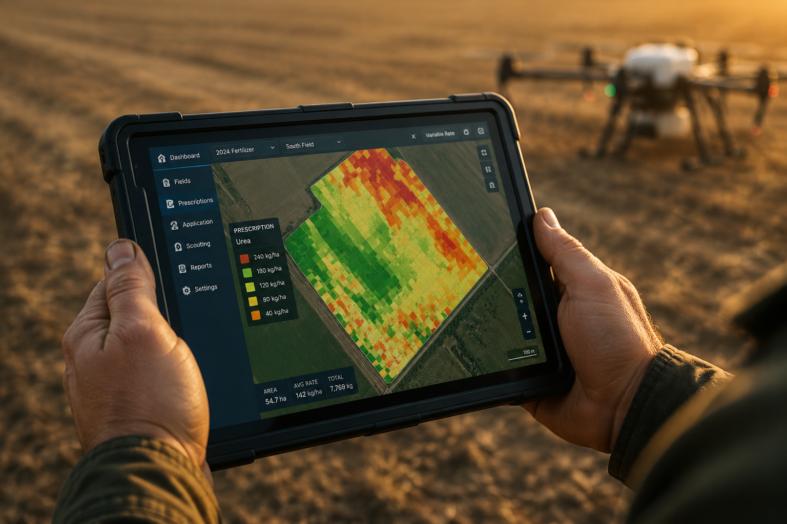
NDVI (Normalized Difference Vegetation Index) is the most widely used metric. It measures the difference between near-infrared light (which healthy plants reflect strongly) and red light (which they absorb). A field map color-coded by NDVI values can reveal underperforming zones, irrigation failures, and nutrient deficiencies that are invisible to the naked eye from ground level.
Companies such as AirScout provide full-season imagery at six-inch pixel resolution, capturing entire fields in single snapshots where every pixel maintains a consistent spatial relationship to every other pixel. This consistency is what makes the data reliable enough to build prescription maps from [4].
FIXAR's UAV platforms support multispectral imaging, NDVI analysis, and precision mapping specifically designed for compatibility with agricultural management systems, meaning the data flows directly into the software farmers already use [7].
How Survey Resolution Affects Decision Quality
Resolution is not simply about image sharpness. At six-inch (approximately 15 cm) pixel resolution, a farmer can identify individual plant rows and spot bare patches caused by seed skips or early pest damage. At one-meter resolution, only broad field zones are distinguishable.
For weed mapping specifically, research using UAVs with multispectral imaging and deep neural networks has demonstrated that fine-resolution imagery combined with semantic segmentation algorithms can identify and map weed distributions at a field scale with high accuracy, enabling targeted rather than blanket herbicide applications [2]. This approach directly reduces input costs while limiting chemical runoff.
How UAVs and Automation Are Transforming Agricultural Land Mapping in Practice

The phrase "precision farming surveys" covers a spectrum of operational approaches, from a single farmer operating a consumer-grade quadcopter to fully automated multi-vehicle systems managed by AI platforms. Understanding where a given operation sits on that spectrum helps determine the right entry point.
Fixed-Wing vs. Multirotor: Choosing the Right Platform
The choice of UAV platform has a direct effect on coverage area, data quality, and cost per acre.
Fixed-wing drones are optimized for large-area coverage. A single flight can cover 500 to 1,500 acres, making them cost-effective for operations mapping thousands of acres per season [5]. Their limitation is that they require a runway or launch catapult and cannot hover, which restricts their use in detailed spot inspections.
Multirotor (quadcopter) drones cover 100 to 400 acres per flight but offer superior maneuverability, the ability to hover for detailed inspection, and simpler launch logistics [5]. For farms under 500 acres or for operations requiring frequent targeted surveys, multirotors are typically the practical choice.
FIXAR's hybrid VTOL (vertical take-off and landing) platforms address both needs, combining the hover capability of a multirotor with the range efficiency of a fixed-wing design, a growing category that is particularly relevant for mid-sized farms in 2026 [7].
Autonomous Ground Vehicles: The Ground Truth Layer
UAV imagery provides an aerial perspective, but some soil and crop measurements require ground-level contact. This is where Unmanned Ground Vehicles (UGVs) complement aerial surveys.
Research into integrated aerial-ground robotic systems has shown that combining UAV data with UGV-based soil sampling creates a more complete picture of field variability than either method alone [3]. The UAV identifies zones of concern; the UGV navigates to those zones autonomously and collects physical samples or applies targeted treatments.
TerraClear's TerraScout autonomous field scout exemplifies this ground-level approach. Equipped with eight cameras providing 1.5mm ground sample distance (GSD) imagery, it operates autonomously covering over 1,000 acres per day and produces real-time prescriptions for field challenges including rock detection, weed identification, and stand assessment [1]. At 1.5mm GSD, the system captures detail that no aerial platform can match, making it a powerful complement to UAV-based surveys.
The AgriColMap framework, developed through academic research, formalizes this integration by combining aerial and ground-based data into comprehensive 3D maps that robotic systems can navigate and act upon directly [3].
AI-Driven Analysis: From Raw Imagery to Actionable Prescriptions
Raw drone imagery has limited value without analysis. The transformation from pixel data to farm management decisions depends on AI and machine learning platforms.
Skysense integrates AI and satellite technology for land cover analysis, stand counts, and autonomous drone patrols for bird mitigation, providing full-service solutions from data acquisition through to analysis and final reporting [6]. Their approach is notable because it removes the need for in-house data science expertise, a significant barrier for many farm operations.
Hylio's AgDrone systems take automation a step further, offering swarm-enabled crop care where multiple drones operate in coordinated patterns to cover large areas while applying treatments with precision, directly reducing chemical usage compared to broadcast application [9].
"The most valuable output of a precision farming survey is not the map itself. It is the prescription that tells a variable-rate applicator exactly where to place inputs and in what quantity."
TerraClear's broader technology platform combines advanced imaging, machine vision, and field-ready robotics to convert raw data into actionable prescriptions at scale [10]. The key principle across all these platforms is the same: data collection is only valuable when it connects to a decision and then to a physical action in the field.
Implementing Precision Farming Surveys: A Practical Guide for Farmers
Understanding the technology is one thing. Putting it to work on a real farm requires a structured approach that accounts for data workflow, regulatory compliance, equipment selection, and return on investment.
Step 1: Define the Survey Objective
Every precision farming survey should begin with a specific management question:
- Where are the yield-limiting zones in this field?
- Which areas need variable-rate nitrogen application?
- Where is drainage inadequate?
- What is the weed pressure distribution across the field?
The answer to that question determines which sensor type, resolution, and analysis method is appropriate. Mapping drainage patterns requires a digital elevation model from LiDAR or stereo photogrammetry. Assessing crop health requires multispectral NDVI data. Identifying rocks or debris requires ultra-high-resolution RGB imagery at ground level.
Step 2: Choose Between In-House and Service Provider
Farms have two primary options for accessing UAV survey data:
In-house drone program:
- Higher upfront cost (equipment, training, software)
- Maximum flexibility for timing and frequency
- Requires CAA/FAA operator certification depending on jurisdiction
- Best suited to operations above 1,000 acres or those requiring weekly monitoring
Third-party drone mapping services:
- Agricultural drone mapping services in the U.S. cost between $2 and $8 per acre for raw orthomosaics and elevation data
- Prescription maps for variable-rate applications add $5 to $15 per acre [5]
- Precision Land Service offers true-color and multispectral mapping, 3D topographic mapping with RTK GPS ground control, and aerial inspections as a complete service package [8]
- Best suited to smaller operations or those conducting one to two surveys per season
Step 3: Establish a Data Workflow
The most common failure point in precision farming survey programs is not the data collection. It is the gap between data delivery and farm management action.
A functional workflow looks like this:
- Flight planning – define field boundaries, set flight altitude, select sensor package
- Data capture – autonomous flight with GPS/RTK positioning for centimeter-level accuracy
- Processing – photogrammetry software (Pix4D, DroneDeploy, Agisoft) generates orthomosaics and DEMs
- Analysis – AI platform generates zone maps, NDVI scores, weed distribution layers
- Prescription generation – variable-rate prescription files created for specific inputs
- Application – prescription files uploaded to variable-rate spreader, sprayer, or planter
- Outcome tracking – yield monitor data compared against prescription zones at harvest
Steps 5 through 7 are where the economic return is generated. Without a clear path from survey data to field action, the investment in mapping produces no measurable benefit.
Step 4: Understand the Regulatory Environment
In the UK, drone operations for commercial purposes including agricultural surveys require CAA authorization under the Drone and Model Aircraft Code. Operators must hold a General Visual Line of Sight Certificate (GVC) or equivalent qualification for operations beyond standard category limits.
For farms considering broader property assessment alongside agricultural surveys, understanding how professional surveying standards apply is valuable context. Just as a building survey follows defined professional standards for property condition assessment, agricultural UAV surveys are increasingly governed by emerging professional frameworks that define data quality, accuracy standards, and reporting requirements.
Similarly, the principle of using systematic inspection to identify defects before they become costly problems, familiar to anyone who has read a comprehensive condition survey report, applies directly to agricultural land. A precision farming survey is, at its core, a condition assessment of the land asset.
Step 5: Calculate Return on Investment
The business case for precision farming surveys rests on three measurable outcomes:
Input cost reduction: Variable-rate application based on prescription maps typically reduces fertilizer and chemical usage by 10% to 20% compared to uniform application rates. On a 2,000-acre corn operation spending $150 per acre on inputs, a 15% reduction represents $45,000 in annual savings.
Yield improvement: Early detection of stress zones, drainage problems, and pest pressure allows timely intervention. Research consistently shows that correcting identified problems before they affect yield produces returns of $20 to $60 per acre depending on crop type and severity of the issue.
Documentation and compliance: Precision survey records provide verifiable evidence of field management practices, increasingly required for sustainability certification programs and crop insurance claims.
The Role of Professional Surveyors in Agricultural Land Assessment
While UAV technology handles crop monitoring and agronomic mapping, agricultural land also requires formal professional assessment for financial, legal, and planning purposes. This is where chartered surveyors play a distinct role alongside precision farming technology.
A stock condition survey of farm buildings and infrastructure, or a formal reinstatement cost valuation of agricultural assets for insurance purposes, requires professional judgment that automated systems cannot replace. Understanding what a property surveyor does in the context of agricultural estates clarifies that drone-based agronomic surveys and professional land surveys serve complementary but distinct purposes.
For farmers who own rather than rent their land, periodic professional assessment of the land asset itself, separate from its agronomic performance, remains an important part of responsible land management. The RICS building survey framework, for example, provides a rigorous standard for assessing farm buildings and structures that UAV imagery alone cannot fully address.
Conclusion
Precision farming surveys powered by UAVs and automation have moved from experimental technology to essential farm management infrastructure. The combination of aerial multispectral imaging, autonomous ground vehicles, and AI-driven analysis platforms gives farmers a level of field intelligence that was simply not achievable a decade ago.
Actionable next steps for farmers considering this technology in 2026:
- Start with a single field objective – choose one specific management question (weed mapping, drainage assessment, or stand count) and commission a trial survey to evaluate data quality and workflow fit.
- Compare service provider costs against in-house investment – for operations under 500 acres, third-party services at $2 to $15 per acre typically offer better economics than equipment ownership.
- Map your data workflow before purchasing equipment – identify which farm management software you use and confirm compatibility with the survey platform before committing to a system.
- Build a baseline dataset in year one – a single season of survey data has limited value; multi-year comparisons reveal trends that drive the most valuable management decisions.
- Integrate professional land assessment alongside agronomic surveys – UAV data optimizes crop production, while professional surveying protects and documents the underlying land asset.
The farms that will outperform their neighbors in the coming decade are not necessarily those with the most land or the largest equipment. They are the ones that best understand what is happening across every acre, in real time, and act on that knowledge with precision.
References
[1] Terrascout – https://www.terraclear.com/technology/terrascout/?utm_source=openai
[2] arxiv – https://arxiv.org/abs/1808.00100?utm_source=openai
[3] arxiv – https://arxiv.org/abs/1911.03098?utm_source=openai
[4] ops.airscout – https://ops.airscout.com/?utm_source=openai
[5] Mapping – https://agdronedirectory.com/services/mapping?utm_source=openai
[6] skysense.ag – https://skysense.ag/?utm_source=openai
[7] Precision Agriculture And Forest Valuation – https://www.fixar.pro/applications/precision-agriculture-and-forest-valuation?utm_source=openai
[8] Drone Agriculture Mapping Services – https://www.precisionlandservice.com/drone-agriculture-mapping-services?utm_source=openai
[9] hyl – https://www.hyl.io/?utm_source=openai
[10] Technology – https://www.terraclear.com/technology/?utm_source=openai