
Nearly one in six properties in England sits within a flood-risk area, yet thousands of buyers complete purchases each year without commissioning a survey that properly examines where their home sits as much as what it is built from. Location risk in UK building surveys, covering everything from busy roads to flood zones and subsidence hotspots, is one of the most underweighted factors in residential and commercial property transactions. A thorough building survey does not stop at the front door; it reads the landscape, the geology, the road network, and the regulatory maps that define what a property's location truly means for long-term value and safety.
Key Takeaways
- Location risk in UK building surveys spans traffic noise and air pollution, fluvial and surface-water flooding, subsidence-prone geology, and access constraints, all of which affect value and insurability.
- England's long-term flood risk service and Flood Zones 2 and 3 remain the primary official references surveyors use; Scotland's SEPA maps provide equivalent multi-layered data north of the border.
- Surface-water flood maps were updated in 2026 to include climate-change depth scenarios, giving surveyors and buyers a clearer picture of future exposure.
- Subsidence risk is strongly tied to soil type and legacy land use; shrink-swell clay and former mining areas require specific investigation beyond a standard visual inspection.
- Understanding location risk empowers buyers to negotiate price adjustments, request specialist reports, and make informed insurance decisions before exchange.
What Location Risk Actually Means in a Building Survey
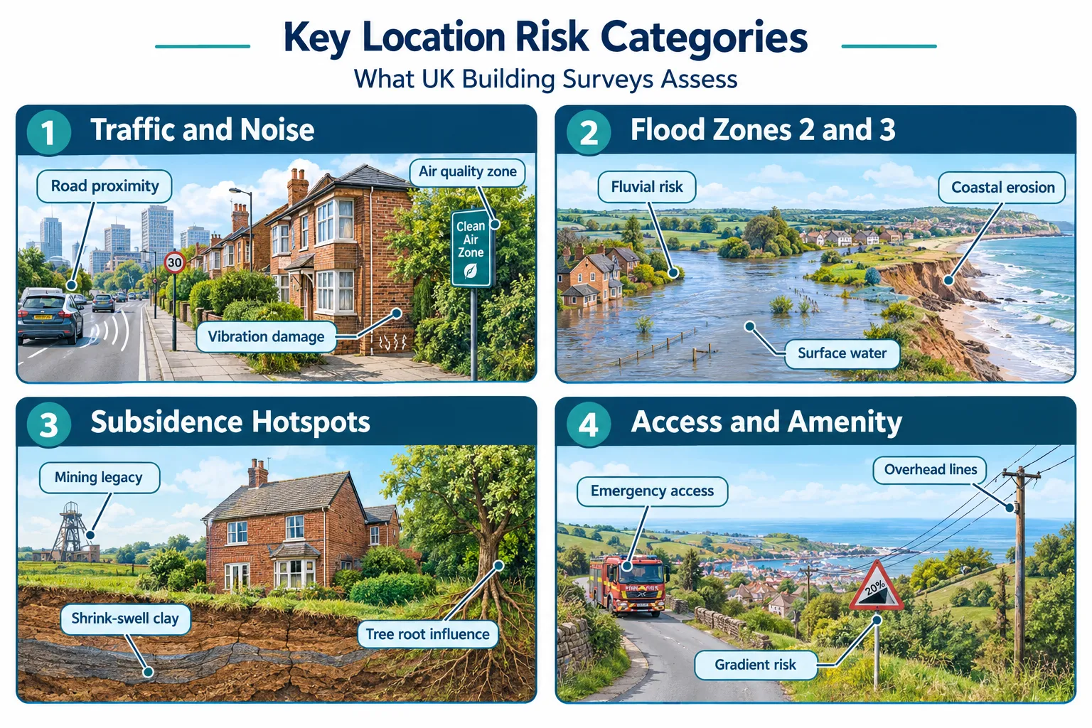
When a chartered surveyor prepares a Level 2 or Level 3 report, the physical condition of the building is only part of the story. Location risk refers to the external environmental, geological, and infrastructural factors that affect a property's safety, usability, and market value, factors that exist regardless of how well the building itself has been maintained.
The four broad categories of location risk assessed in professional surveys are:
- Traffic, noise, and air quality, proximity to busy roads, motorways, flight paths, and industrial zones.
- Flood risk, fluvial (river), tidal, surface-water, and groundwater flooding.
- Subsidence and ground instability, shrink-swell clay, former mining, landfill, and tree-root influence.
- Access, utility, and amenity constraints, steep gradients, overhead power lines, rights of way, and emergency-vehicle access.
Each category feeds directly into the surveyor's risk assessment and, crucially, into buyer negotiation strategy. A property that scores poorly across multiple categories may warrant a significant price reduction, specialist investigations, or in some cases, a decision not to proceed at all.
"A survey that ignores where a property sits is like a medical check-up that ignores the patient's lifestyle. The building and its environment are inseparable."
For buyers unsure which level of survey addresses location risk most thoroughly, the compare different types of survey guide provides a clear breakdown of what each report covers.
Traffic, Noise, and Air Quality: The Road Risk Dimension
Properties adjacent to busy roads present a cluster of interrelated risks that surveyors must assess both visually and through reference to external data sources.
Structural Impact of Traffic Vibration
Heavy goods vehicles and high-frequency traffic generate ground vibration that, over time, can contribute to:
- Cracking in masonry, particularly in older, unreinforced brickwork.
- Settlement of shallow foundations, especially on loose or sandy soils.
- Deterioration of pointing and render, accelerating moisture ingress.
A full structural survey will document crack patterns and assess whether they are consistent with vibration-related movement or other causes such as subsidence or thermal expansion.
Noise and Its Effect on Value
UK road noise is assessed against the Environmental Noise Regulations 2006, which implement the EU Environmental Noise Directive. Properties within noise-mapped corridors, typically within 150 metres of a major road or 300 metres of a motorway, can suffer measurable value suppression. Research consistently shows that each decibel increase above ambient levels reduces residential values by between 0.5% and 1.5%, depending on location.
Surveyors note road proximity in their reports but will typically recommend a specialist acoustic assessment for properties where noise is likely to be a significant factor.
Air Quality and Health Risk
The UK's Clean Air Zones and the government's Air Quality Index provide postcode-level data on nitrogen dioxide (NO2) and particulate matter (PM2.5) concentrations. Properties in declared Air Quality Management Areas (AQMAs) carry a disclosure obligation in some local authority searches. Surveyors flag AQMA status as a material location risk, particularly for properties marketed to families with young children or buyers with respiratory conditions.
Flood Risk: The Most Regulated Location Risk in UK Building Surveys
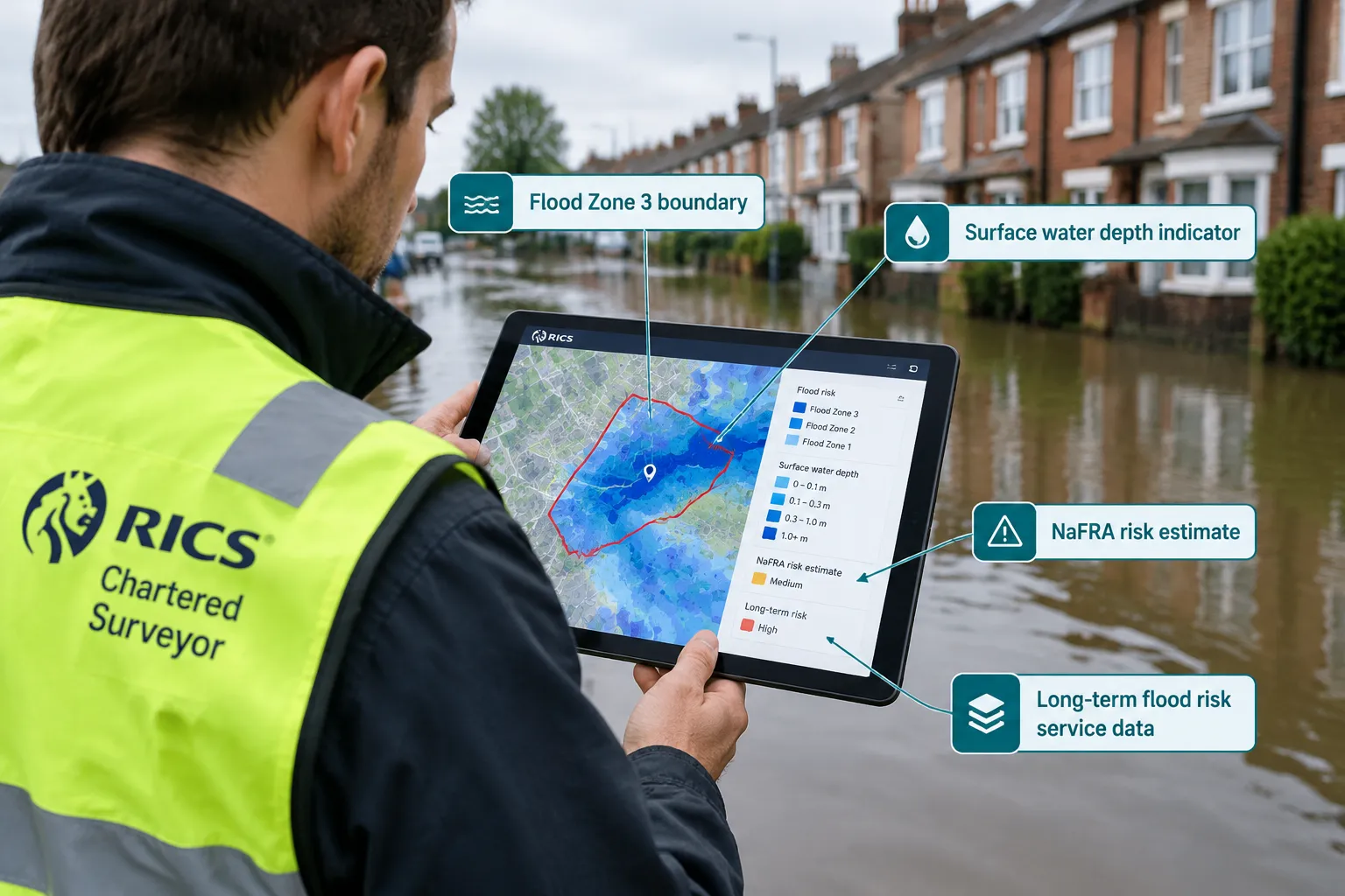
Flood risk is the most extensively mapped and officially regulated dimension of location risk in UK building surveys. The framework is built around several overlapping data sources that surveyors cross-reference when preparing reports.
Flood Zones 2 and 3: The Planning Baseline
England's Flood Map for Planning [5] divides land into three zones:
| Zone | Description | Annual Flood Probability |
|---|---|---|
| Zone 1 | Low probability | Less than 0.1% (1 in 1,000) |
| Zone 2 | Medium probability | 0.1% to 1% (1 in 1,000 to 1 in 100) |
| Zone 3 | High probability | Greater than 1% (1 in 100 or greater) |
Properties in Flood Zone 3 face the most significant restrictions under the National Planning Policy Framework and are subject to Sequential and Exception Tests for new development. For existing properties, Zone 3 designation directly affects insurance availability and premium levels.
England's Long-Term Flood Risk Service
The primary official tool for location risk assessment in England is the government's Check Long Term Flood Risk service [1]. This service, refreshed with updated NaFRA (National Flood and Coastal Erosion Risk Assessment) data [7], provides address-level assessments covering:
- Risk from rivers and the sea
- Risk from surface water
- Risk from reservoirs
- Risk from groundwater
The service now incorporates climate-change projections, allowing surveyors and buyers to assess not just current risk but anticipated exposure over a 30 to 50-year ownership horizon [3].
Surface-Water Flood Maps: A Growing Priority
Surface-water flooding, caused by rainfall overwhelming drainage systems rather than rivers bursting their banks, is increasingly recognised as a distinct and serious risk. The Risk of Flooding from Surface Water maps [4] [10] now include depth and climate-change scenario data, enabling surveyors to identify properties where even moderate rainfall events could result in internal flooding. This is particularly relevant in urban areas where impermeable surfaces have increased run-off rates significantly.
Friends of the Earth data indicates that climate change is expected to increase the frequency and severity of UK flooding events throughout the coming decades [2], making long-term surface-water risk data an essential component of any thorough location risk assessment.
Live Flood Forecasts vs Long-Term Risk Data
An important distinction exists between long-term risk datasets and live flood forecasts. The Check for Flooding service [6] provides real-time warnings and alerts but is designed for immediate safety decisions rather than property transactions. Surveyors rely on the long-term datasets for reports, while buyers can use live services to monitor a property's environment between survey and completion.
Scotland: SEPA's Multi-Layered Flood Maps
For properties in Scotland, SEPA (Scottish Environment Protection Agency) provides the equivalent resource through its flood maps portal [8] [9]. SEPA's mapping covers fluvial, coastal, and surface-water flood extents, with depth and defence information layered for professional use. Scottish surveyors incorporate SEPA data into location risk assessments in the same way their English counterparts use the government's long-term flood risk service.
Flood Risk and Buyer Negotiation
When a survey identifies significant flood risk, buyers have several practical options:
- Request a specialist flood risk assessment from a qualified engineer or hydrologist.
- Obtain flood insurance quotes before exchange to understand the cost impact.
- Negotiate a price reduction reflecting the cost of flood resilience measures (flood doors, air-brick covers, raised electrical sockets).
- Review the seller's flood history, the Property Information Form (TA6) requires disclosure of past flooding events.
The do I need a home survey when buying a home guide explains how survey findings, including flood risk, feed into the negotiation process.
Subsidence Hotspots: Ground Risk Beneath the Surface
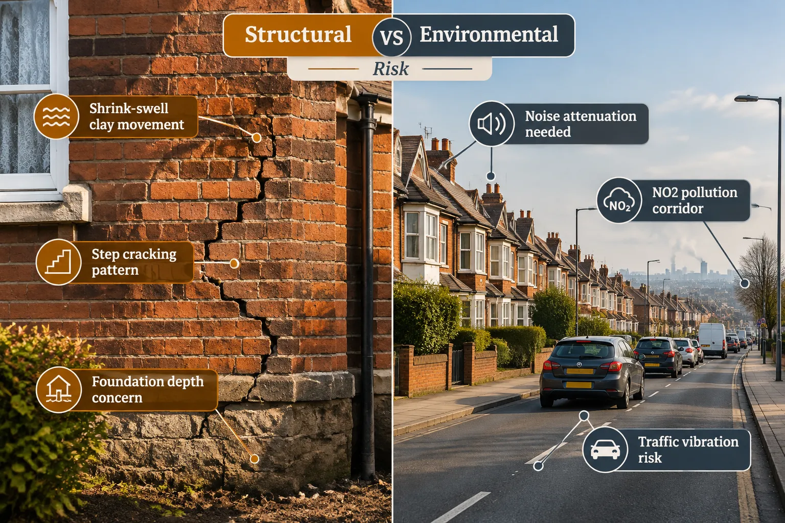
Subsidence is the downward movement of ground beneath a building's foundations, and it is one of the most costly and complex risks a property buyer can encounter. Location risk in UK building surveys, from busy roads to flood zones and subsidence hotspots, is nowhere more technically demanding than in the assessment of ground stability.
The Main Causes of Subsidence in the UK
Shrink-swell clay is the single largest cause of subsidence in England. Clay soils expand when wet and contract when dry, creating cyclical movement that can cause significant structural damage over time. The areas of highest risk include:
- London and the South East (London Clay)
- Essex and parts of East Anglia
- The Midlands clay belt
- Parts of the South West
Tree root influence compounds clay-related subsidence. Large trees within 15 metres of a property can extract moisture from clay soils, accelerating shrinkage during dry summers. Surveyors assess tree species, proximity, and root spread as part of a location risk evaluation.
Former mining and industrial land presents a different type of ground risk. Coal mining legacy areas in South Wales, the North East, Yorkshire, and parts of the Midlands can be subject to:
- Mine shaft collapse
- Shallow mine workings causing surface subsidence
- Contaminated land from former industrial processes
The Coal Authority's interactive map is a standard reference tool for surveyors working in affected regions.
Landfill and made ground introduce risks of differential settlement, methane generation, and contamination. Properties built on or adjacent to former landfill sites require specialist ground investigation reports.
How Surveyors Identify Subsidence Risk
A Level 3 building survey will examine:
- Crack patterns, diagonal cracks at window and door corners are a classic indicator of differential settlement.
- Door and window alignment, sticking or distorted frames suggest foundation movement.
- Floor levels, sloping or uneven floors in older properties may indicate ongoing settlement.
- External ground levels, raised ground against walls can indicate heave or poorly managed drainage.
Where visual inspection raises concerns, surveyors will recommend a specialist structural engineer's report or a ground investigation survey. A solid floor slab survey may also be warranted where ground-floor construction is of unknown type or age.
Subsidence and Insurance
Properties with a history of subsidence, or located in high-risk geological zones, can face:
- Higher buildings insurance premiums
- Exclusions for subsidence-related claims
- Requirements for underpinning before cover is granted
Insurance market data consistently shows that subsidence claims in the UK peak following hot, dry summers, a pattern likely to intensify as climate change increases the frequency of drought conditions.
Integrating Location Risk Into the Survey Report and Negotiation Strategy
A professional survey report does not simply list location risks in isolation. It contextualises them, assigns severity ratings, and provides actionable recommendations. The full structural survey sample comprehensive guide example illustrates how a well-structured report presents location risk findings alongside building condition data.
The Surveyor's Risk-Rating Framework
Most RICS-compliant reports use a three-tier condition rating system:
- Condition Rating 1, No repair currently needed.
- Condition Rating 2, Defects that need repairing or monitoring but are not considered serious.
- Condition Rating 3, Defects that are serious and/or need to be repaired, replaced, or investigated urgently.
Location risk factors, flood zone designation, proximity to a busy road, subsidence-prone geology, are typically reported as contextual information rather than condition ratings, but they inform the overall risk profile and the surveyor's recommendations for further investigation.
Using Survey Findings to Negotiate
Buyers who receive a survey identifying significant location risks should:
- Quantify the financial impact, obtain quotes for flood resilience measures, acoustic glazing, or structural investigations.
- Use specialist reports as leverage, a specialist flood risk assessment or mining report that confirms elevated risk provides objective grounds for a price reduction.
- Revisit the insurance market, obtain indicative premiums before exchange; if insurance is prohibitively expensive or unavailable, this is a material factor in the decision to proceed.
- Consider the resale implications, a property in a high-risk location may be harder to sell in future, particularly as climate-related risks become more widely understood by buyers.
For commercial properties, location risk carries additional dimensions including planning restrictions, business interruption from flooding, and compliance with environmental regulations. The commercial building surveys service addresses these factors within a commercial context.
Buyers in specific areas can access locally knowledgeable chartered surveyors who understand the particular location risks of their region. For example, properties in Hammersmith face Thames tidal flood risk, while properties in Leatherhead sit on the Mole Valley floodplain, both requiring surveyors with specific local knowledge of those risk profiles.
Conclusion
Location risk in UK building surveys, from busy roads to flood zones and subsidence hotspots, is not a secondary concern to be addressed after the roof and the boiler. It is a foundational dimension of any thorough property assessment, one that directly affects insurability, long-term value, and the safety of the people who live or work in the building.
Actionable next steps for buyers and property owners in 2026:
- Commission a Level 3 building survey for any property in a known flood zone, subsidence hotspot, or busy road corridor, a Level 2 report may not provide sufficient detail.
- Cross-reference the government's long-term flood risk service [1] and, for Scottish properties, SEPA's flood maps [8], before making an offer.
- Ask the surveyor explicitly about surface-water flood risk, not just river and coastal flooding, this is now the fastest-growing category of flood damage in the UK.
- Obtain a Coal Authority or mining report for properties in legacy mining areas; this is a low-cost check that can prevent a very expensive mistake.
- Use survey findings to negotiate, location risk is a quantifiable factor, and a well-evidenced report gives buyers legitimate grounds to seek a price reduction or request remediation.
To find out which survey level is right for a specific property and location, use the what survey do you need tool or contact Notting Hill Surveyors for a free survey quote.
References
[1] Check Long Term Flood Risk – https://www.gov.uk/check-long-term-flood-risk
[2] Flooding UK – https://friendsoftheearth.uk/climate/flooding-uk
[3] Long Term Flood Risk – https://www.data.gov.uk/collections/environment/long-term-flood-risk
[4] Risk Of Flooding From Surface Water Understanding And Using The Map – https://www.gov.uk/government/publications/flood-risk-maps-for-surface-water-how-to-use-the-map/risk-of-flooding-from-surface-water-understanding-and-using-the-map
[5] flood-map-for-planning.service.gov.uk – https://flood-map-for-planning.service.gov.uk/
[6] check-for-flooding.service.gov.uk – https://check-for-flooding.service.gov.uk/?v=map-live&lyr=mv,ts,tw,ta
[7] Updates To National Flood And Coastal Erosion Risk Information – https://www.gov.uk/guidance/updates-to-national-flood-and-coastal-erosion-risk-information
[8] Floodmaps – https://map.sepa.org.uk/floodmaps
[9] map.sepa.org.uk – https://map.sepa.org.uk/floodmap/map.htm
[10] Flood Risk Maps For Surface Water How To Use The Map – https://www.gov.uk/government/publications/flood-risk-maps-for-surface-water-how-to-use-the-map