
Over 45% of data breaches in 2024 involved information stored in the cloud — and surveying firms, which increasingly depend on real-time GIS platforms and cloud-hosted project data, sit squarely in the crosshairs [2]. Cybersecurity Essentials for Surveyors: Protecting GIS and Cloud Data in 2026 is no longer a topic reserved for IT departments. It is a professional obligation that affects every chartered surveyor, property consultant, and mapping specialist who handles sensitive spatial, structural, or client data in a digital environment.
The surveying profession has undergone a rapid digital transformation. Drone-captured imagery, LiDAR point clouds, boundary data, and client property records now flow through cloud platforms in real time. That convenience introduces serious exposure. Whether a firm operates from chartered surveyor offices in Surrey or manages projects across multiple London boroughs, the threat landscape is the same: sophisticated attackers, misconfigured storage buckets, and under-trained staff.
This guide breaks down the specific risks surveyors face, the protocols that reduce those risks, and the practical steps firms can take in 2026 to protect their most valuable digital assets.
Key Takeaways
- More than 32% of cloud assets are neglected, each carrying an average of 115 unresolved vulnerabilities — a critical risk for surveying firms storing GIS data in the cloud [1].
- Misconfigurations remain the leading cause of cloud breaches, not sophisticated hacking.
- A zero-trust security model is the most effective framework for protecting surveying data across distributed teams.
- Multi-factor authentication (MFA) and AES-256 encryption are non-negotiable baseline controls in 2026.
- Regular data classification, security audits, and staff training are as important as technical controls.
The Threat Landscape Facing Surveyors in 2026
Surveying firms are not immune to cyberattacks simply because they are not banks or hospitals. In fact, their relative lack of dedicated cybersecurity resources makes them attractive targets. Understanding the specific threats is the first step in applying cybersecurity essentials for surveyors: protecting GIS and cloud data in 2026.
Why Surveyors Are Targeted
Surveying practices hold a surprisingly rich mix of sensitive data:
- Personal client information — names, addresses, financial details tied to property transactions
- Geospatial datasets — precise boundary coordinates, topographic surveys, and infrastructure maps
- Structural reports — detailed condition assessments that could inform targeted property crimes
- Legal documents — party wall agreements, schedule of condition reports, and planning submissions
This data has real-world value. Stolen property boundary data can be used in fraudulent conveyancing. Leaked structural surveys expose vulnerabilities in high-value properties. Client contact details feed phishing campaigns.
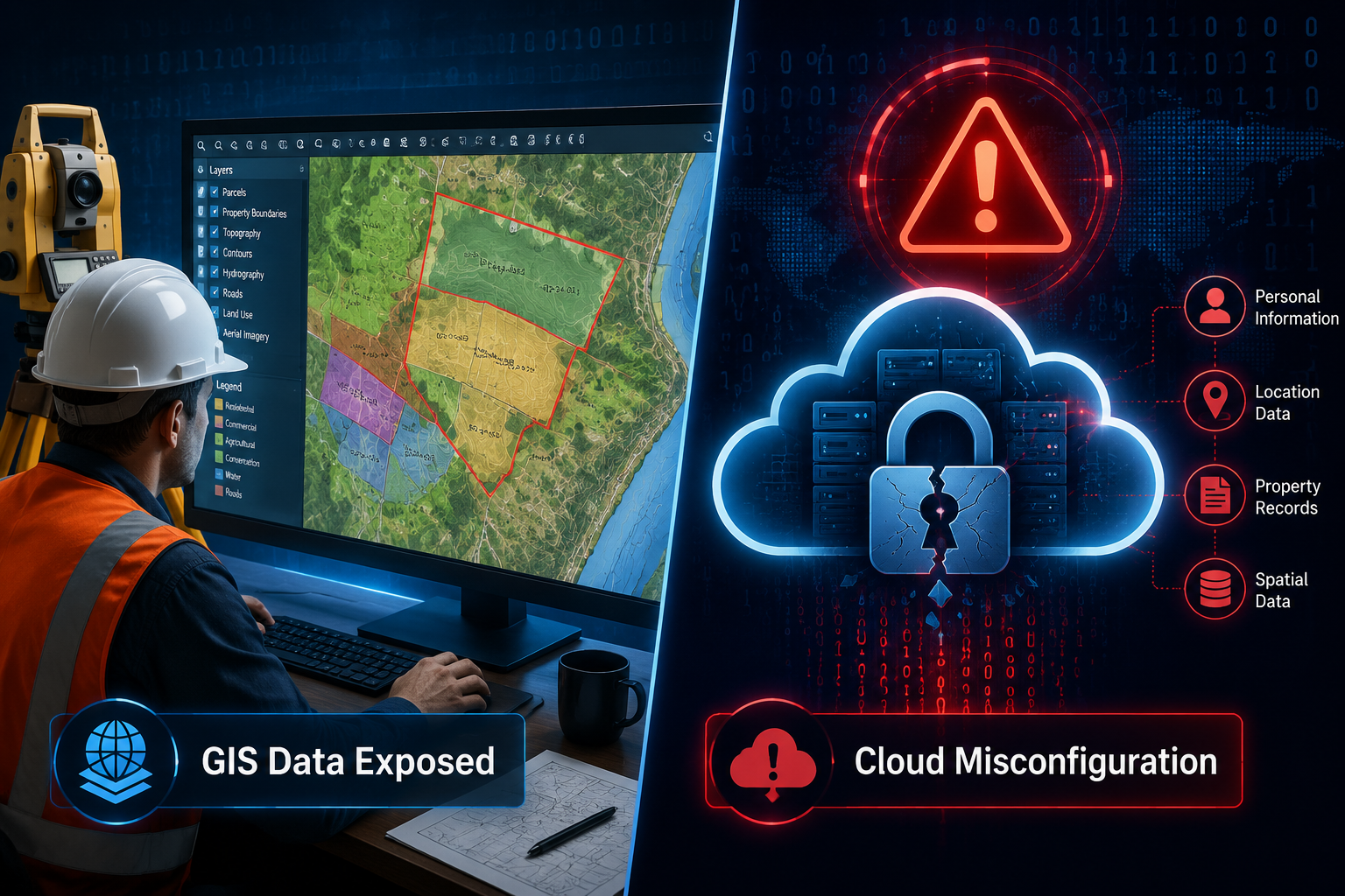
The Cloud Misconfiguration Problem
The most common attack vector is not a sophisticated zero-day exploit. It is a misconfigured cloud storage bucket left open to the public internet. In 2025, 70% of organizations accelerated their cloud migration — but speed and security rarely travel together [1]. Rushed migrations leave default settings in place, permissions too broad, and logging disabled.
Key statistics surveyors need to know:
| Threat Vector | Scale of Risk |
|---|---|
| Cloud assets that are neglected | 32% of all cloud assets [1] |
| Average unresolved vulnerabilities per neglected asset | 115 [1] |
| Data breaches involving cloud-stored data | Over 45% by 2024 [2] |
| Organizations that accelerated cloud migration in 2025 | 70% [1] |
Ransomware Targeting Storage Systems
Ransomware groups have evolved. Modern attacks specifically target backup repositories and cloud storage systems, knowing that destroying backups eliminates a firm's ability to recover without paying [9]. For surveyors, a ransomware attack that encrypts active GIS project files and deletes cloud backups can bring an entire practice to a standstill — with severe legal and financial consequences.
A real-world pattern seen across professional services firms involves attackers gaining initial access through a phishing email, moving laterally through the network, identifying cloud storage credentials, and then deploying ransomware across both local and cloud-hosted data simultaneously. The attack is designed to maximize leverage.
Core Security Protocols Every Surveying Firm Must Implement
Addressing cybersecurity essentials for surveyors protecting GIS and cloud data in 2026 requires a layered approach. No single tool or policy is sufficient. The following protocols form the foundation of a defensible security posture.
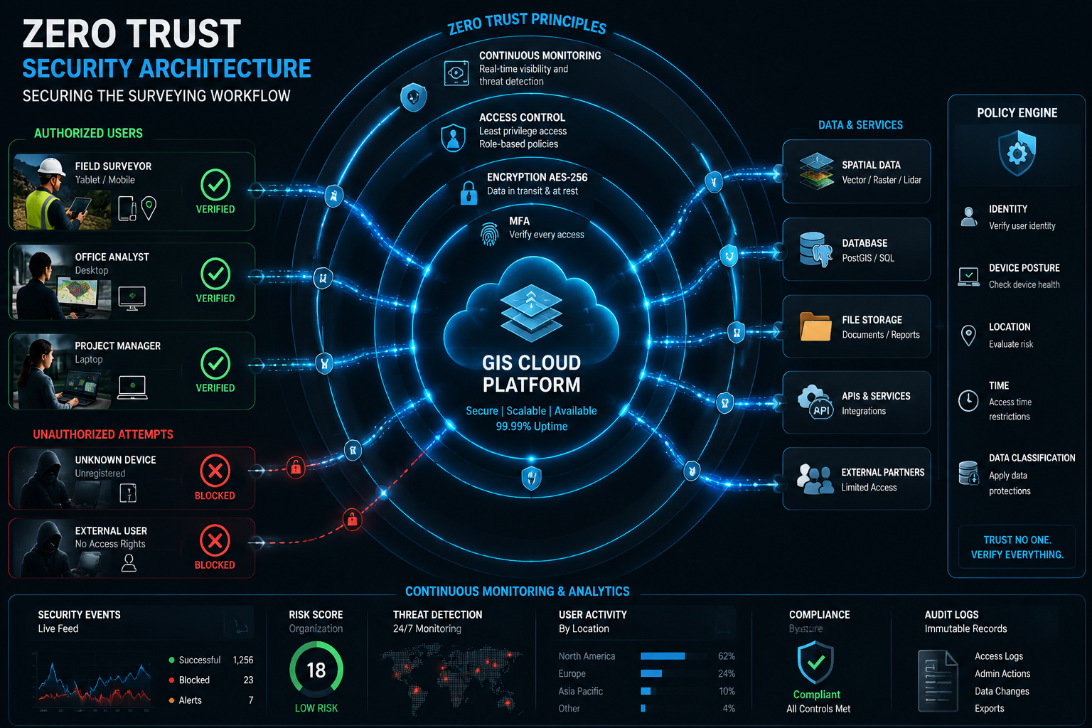
1. Adopt a Zero-Trust Security Model
The zero-trust principle is straightforward: trust nothing, verify everything. Every access request — whether from inside or outside the office network — must be authenticated and authorized before it is granted [3].
For surveying firms, this means:
- No implicit trust for devices on the internal network
- Continuous verification of user identity throughout a session
- Least-privilege access — users can only access the data they need for their specific role
- Micro-segmentation of GIS platforms from other business systems
This model is particularly important for firms with remote surveyors accessing cloud-hosted project data from client sites or home offices. A surveyor conducting a full structural survey may upload high-resolution images and detailed condition notes from a mobile device on an unsecured network. Zero-trust ensures that even if that network is compromised, the attacker cannot move freely through the firm's systems.
2. Enforce Multi-Factor Authentication Across All Systems
MFA is one of the highest-return security investments available. It significantly reduces the risk of unauthorized access even when credentials are stolen [5]. In 2026, MFA should be considered a baseline requirement, not an optional extra.
MFA should be enforced for:
- Cloud storage platforms (AWS S3, Azure Blob, Google Cloud Storage)
- GIS software with cloud sync capabilities
- Email accounts
- Remote desktop and VPN connections
- Any system containing client data
Hardware security keys (such as FIDO2-compliant devices) provide stronger protection than SMS-based codes, which remain vulnerable to SIM-swapping attacks.
3. Encrypt Data in Transit and at Rest
Encryption ensures that even if data is intercepted or a storage system is accessed without authorization, the information remains unreadable.
- Data in transit: Use TLS 1.3 for all data moving between devices, servers, and cloud platforms [8]
- Data at rest: Apply AES-256 encryption to all stored files, including GIS datasets, survey reports, and client records [8]
- Key management: Store encryption keys separately from the data they protect, using a dedicated key management service
Firms that handle RICS building surveys or homebuyer survey data should treat all client-related files as sensitive and apply encryption as a default, not an exception.
4. Classify and Inventory Your Data Regularly
You cannot protect data you do not know exists. Conducting comprehensive data discovery scans across all cloud storage services identifies sensitive data that may have been uploaded without proper controls [6].
A practical data classification framework for surveyors:
| Classification Level | Examples | Required Controls |
|---|---|---|
| Confidential | Client personal data, financial records | Encryption, MFA, strict access control |
| Restricted | GIS boundary data, structural reports | Encryption, role-based access |
| Internal | Project timelines, internal communications | Standard access controls |
| Public | Marketing materials, general guidance | Basic access controls |
Regular classification audits — at minimum quarterly — ensure that data does not drift into the wrong storage tier or become accessible to unauthorized users.
5. Protect Backup Repositories as High-Value Targets
Backups are the last line of defense against ransomware. Treating backup repositories as an afterthought is a critical mistake [4]. Surveyors should implement:
- Air-gapped backups: At least one backup copy stored offline and completely disconnected from the network
- Immutable storage: Configure cloud backups so that data cannot be modified or deleted for a defined retention period
- Strict access controls: Limit who can access, modify, or delete backup data
- Regular restoration testing: A backup that has never been tested is not a reliable backup
The 3-2-1 rule remains the gold standard: three copies of data, on two different media types, with one stored offsite.
Building a Sustainable Cybersecurity Culture in Surveying Practices
Technical controls alone are not enough. The majority of successful cyberattacks exploit human behavior — phishing emails, weak passwords, and accidental data sharing. Cybersecurity essentials for surveyors protecting GIS and cloud data in 2026 must include a cultural dimension.
Understand the Shared Responsibility Model
Cloud service providers secure the underlying infrastructure. Surveyors are responsible for securing their data, applications, and access controls within that infrastructure [3]. This division is frequently misunderstood, leading firms to assume their cloud provider handles security end-to-end.
What cloud providers typically secure:
- Physical data centers
- Network infrastructure
- Hypervisor and virtualization layers
What surveyors must secure:
- Data stored in cloud services
- User access and identity management
- Application configurations
- Data classification and encryption settings
Centralize Security Monitoring and Telemetry
Forwarding cloud storage logs to a centralized security analytics platform enables proactive threat detection [4]. Anomalies such as large data transfers at unusual hours, access from unexpected geographic regions, or repeated failed login attempts can indicate an active intrusion.
For firms managing monitoring surveys or large-scale GIS projects, integrating cloud telemetry into a Security Information and Event Management (SIEM) platform provides the visibility needed to detect and respond to threats before they escalate.
Conduct Regular Security Audits and Compliance Checks
Periodic security audits identify vulnerabilities before attackers do [7]. For surveying firms, audits should cover:
- Access control reviews: Who has access to what, and is that access still necessary?
- Configuration audits: Are cloud storage buckets, databases, and APIs correctly configured?
- Patch management: Are all software systems, including GIS platforms and mobile survey apps, running current versions?
- Compliance checks: Does the firm meet its obligations under UK GDPR and any sector-specific data protection requirements?
Annual audits are a minimum. Quarterly reviews of access controls and configurations are strongly recommended for firms handling large volumes of sensitive property data.
Train Staff Continuously, Not Just Once
A one-time cybersecurity training session is insufficient. Threats evolve, and so must staff awareness. Effective training programs include:
- Phishing simulations: Regular test emails that mimic real attack techniques
- Role-specific training: A surveyor uploading field data faces different risks than an office administrator processing invoices
- Clear incident reporting procedures: Staff must know exactly what to do and who to contact if they suspect a breach
- Leadership engagement: Security culture starts at the top; senior partners and directors must visibly prioritize cybersecurity
Firms that invest in building a genuine security culture — where staff feel empowered to report suspicious activity without fear of blame — consistently outperform those that treat cybersecurity as a compliance checkbox [1].

Practical Implementation Roadmap for 2026
Translating principles into action requires a structured approach. The following roadmap provides a prioritized sequence for surveying firms at different stages of cybersecurity maturity.
Immediate Actions (Within 30 Days)
- Enable MFA on all cloud accounts and email systems
- Audit current cloud storage configurations and close any publicly accessible buckets
- Verify that all data backups are functioning and test one restoration
- Review who has administrative access to GIS platforms and remove unnecessary privileges
Short-Term Actions (30-90 Days)
- Implement a data classification policy and conduct an initial inventory scan
- Deploy TLS 1.3 and AES-256 encryption across all data storage and transfer systems
- Begin zero-trust implementation, starting with remote access controls
- Establish a centralized logging and monitoring solution
Ongoing Actions
- Conduct quarterly access control reviews
- Run annual security audits with external assessors
- Deliver continuous staff training, including phishing simulations
- Stay current with ransomware trends targeting storage systems and update defenses accordingly [9]
Firms that work with a chartered surveyor in North London or operate across regions such as Hertfordshire and Buckinghamshire should ensure that regional offices and remote staff follow the same security protocols as the central practice. Inconsistent application of controls is a common vulnerability.
Conclusion
The digital tools that make modern surveying faster and more accurate also create real cybersecurity obligations. GIS platforms, cloud-hosted project data, and real-time field uploads represent both professional assets and potential liabilities. Cybersecurity essentials for surveyors protecting GIS and cloud data in 2026 demand a layered, proactive, and culturally embedded approach — not a one-time fix.
Actionable next steps for surveying firms:
- Audit all cloud storage configurations this week and remediate any open or misconfigured buckets
- Enable MFA on every system that holds client or project data, starting today
- Establish a formal data classification policy and assign ownership for each data category
- Schedule an external security audit for the current quarter
- Invest in ongoing staff training that addresses the specific risks surveyors face in the field and in the office
- Review backup procedures and implement immutable storage for all critical GIS and survey data
The cost of a data breach — financial, reputational, and legal — far exceeds the cost of prevention. Firms that treat cybersecurity as a core professional competency in 2026 will be better positioned to protect their clients, their data, and their long-term reputation.
References
[1] Cloud Security Best Practices 2026 – https://techvorta.com/cloud-security-best-practices-2026/?utm_source=openai
[2] Cloud Security Best Practices 2026 – https://www.gitnexa.com/blogs/cloud-security-best-practices-2026?utm_source=openai
[3] Top Cloud Security Best Practices – https://www.sysdig.com/learn-cloud-native/top-cloud-security-best-practices?utm_source=openai
[4] Data Storage Security Best Practices For Avoiding Cyberattacks – https://www.techtarget.com/searchstorage/tip/Data-storage-security-best-practices-for-avoiding-cyberattacks?utm_source=openai
[5] 1aws Cloud Security Best Practices Guide – https://blog.qualys.com/product-tech/2026/04/09/1aws-cloud-security-best-practices-guide?utm_source=openai
[6] Cloud Data Security Risks Best Practices – https://orca.security/resources/blog/cloud-data-security-risks-best-practices/?utm_source=openai
[7] Cloud Security Best Practices – https://cloudconsultingfirms.com/insights/cloud-security-best-practices/?utm_source=openai
[8] Data Transfer Security – https://www.filecloud.com/blog/data-transfer-security/?utm_source=openai
[9] Ransomware Trends Targeting Storage Systems – https://www.techtarget.com/searchstorage/tip/Ransomware-trends-targeting-storage-systems?utm_source=openai