
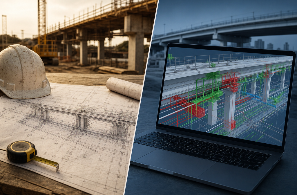
A single coordination error on a major infrastructure project can cost millions to fix once construction is underway. Yet a 2020 study by Autodesk and FMI found that poor data and miscommunication cost the global construction industry an estimated $1.8 trillion annually. The answer to this persistent problem lies in the deliberate fusion of two powerful disciplines: Building Information Modeling (BIM) and professional surveying. BIM and Surveying Synergy: Enhancing Accuracy in Infrastructure Projects is not simply a trend — it is fast becoming the standard methodology for delivering roads, bridges, utilities, and water infrastructure on time, within budget, and to specification.
This article explores how survey data feeds directly into BIM environments to create seamlessly coordinated project workflows, supported by real infrastructure case studies from across the industry.
Key Takeaways
- Survey data captured through laser scanning, total stations, and GPS forms the foundational layer of any accurate BIM model for infrastructure.
- Integrating BIM with Geographic Information Systems (GIS) creates a shared source of truth that improves planning, design, and long-term asset management.
- Real-world case studies — including Thames Water and the Pacific Motorway Upgrade — demonstrate measurable savings in time and cost when BIM and surveying are properly aligned.
- Automated pipelines now allow survey geometry to be transformed into intelligent, data-rich BIM models with minimal manual intervention.
- Professional surveyors play a critical role throughout the BIM lifecycle, not just at the data-capture stage.

How Survey Data Becomes the Foundation of BIM Models
At its core, BIM is only as reliable as the real-world data that underpins it. A 3D model built on inaccurate or incomplete survey data will generate coordination errors, clashes, and costly rework downstream. This is why the relationship between surveying and BIM is not merely complementary — it is structural.
Survey data enters BIM workflows through several key methods:
| Survey Method | Output | BIM Application |
|---|---|---|
| Terrestrial Laser Scanning (TLS) | Point cloud data | Existing conditions modeling, clash detection |
| GNSS/GPS Survey | Georeferenced coordinates | Site positioning, alignment modeling |
| Drone/UAV Photogrammetry | Orthophotos, DSMs | Earthworks, topographic modeling |
| Robotic Total Station | Precise 3D coordinates | Setting-out, as-built verification |
| Ground Penetrating Radar | Subsurface data | Utility mapping, foundation design |
Once captured, this data is processed and imported into BIM authoring platforms such as Autodesk Revit, Civil 3D, or Bentley OpenRoads. The point cloud becomes a reference skeleton around which the intelligent model is built. Every wall, pipe, beam, and road alignment is modelled in relation to verified survey coordinates.
This is particularly important for infrastructure projects where existing conditions — buried utilities, legacy structures, and variable ground levels — must be accurately represented before a single design decision is made. For professionals wanting to understand the broader role surveyors play across different project types, the complete guide to home surveying provides useful context on how survey principles translate across scales.
"The quality of a BIM model is directly proportional to the quality of the survey data that feeds it. Garbage in, garbage out — no matter how sophisticated the software."
Severn Partnership, a specialist in infrastructure surveying, emphasises that BIM for infrastructure requires detailed collaboration between surveyors and design teams from the earliest project stage to agree on specifications, coordinate systems, and model tolerances [7]. Without this alignment, even the most sophisticated BIM platform cannot compensate for survey data that lacks the required accuracy or coverage.
Real Infrastructure Case Studies: BIM and Surveying Synergy in Action
The most compelling evidence for the value of BIM and Surveying Synergy: Enhancing Accuracy in Infrastructure Projects comes not from theory, but from documented project outcomes. Several landmark infrastructure projects demonstrate what becomes possible when survey data and BIM are integrated from the outset.
Thames Water Treatment Works: Digital Twin Without Disruption
SOCOTEC delivered a combined surveying and BIM solution for Thames Water's treatment facility, one of the most technically demanding environments for survey work — a fully operational plant where downtime was not an option. The team created a fully coordinated digital twin of the facility using laser scanning and BIM modelling, all without interrupting water treatment operations.
The results were significant: the project achieved 40% cost savings compared to traditional survey and design methods, and reduced modelling time from six months to just eight weeks [1]. The digital twin now serves as a living asset record, supporting ongoing maintenance and future capital works.
This project illustrates a critical advantage of the BIM-survey integration: the ability to capture complex existing conditions accurately and translate them into a model that serves the entire asset lifecycle — not just the construction phase.
Pacific Motorway Upgrade: Collaborative Civil BIM at Scale
Jacobs Engineering used 12d Synergy to support civil BIM delivery on the Pacific Motorway Upgrade (M1/M3/Gateway Merge) in Queensland, Australia. The project required coordinated BIM delivery across multiple offices and disciplines, with strict data integrity requirements.
By deploying 12d Synergy as a central data management environment, Jacobs improved collaboration between survey, design, and construction teams, maintained data integrity across the project lifecycle, and established replicable BIM workflows applicable to future conventional infrastructure projects [3]. The motorway project demonstrated that flexible, cloud-connected data environments are essential when survey data must flow seamlessly into civil design models across geographically dispersed teams.
HNTB: Merging BIM and GIS for Stakeholder Clarity
HNTB, a major US infrastructure firm, integrated BIM with Geographic Information Systems (GIS) using Autodesk Build and Esri ArcGIS Online. This combination allowed survey-derived spatial data to be visualised at both the micro-level (individual structure components) and the macro-level (regional corridor planning) within a single connected environment [2].
The BIM-GIS integration improved stakeholder engagement significantly — non-technical decision-makers could interact with project data through familiar map-based interfaces, while engineers worked within detailed BIM environments. This dual-layer approach reduced communication gaps and accelerated approval processes.
As Arkance notes, integrating BIM and GIS moves infrastructure delivery from siloed data management to a shared source of truth, delivering value to agencies, contractors, and communities alike [6].

The Technical Mechanics of BIM and Surveying Synergy: Enhancing Accuracy in Infrastructure Projects
Understanding why this synergy works requires a closer look at the technical pipeline — from raw survey data capture to a fully coordinated, construction-ready BIM model.
Step 1: Georeferencing and Coordinate System Alignment
Every infrastructure BIM model must be anchored to a real-world coordinate system. Surveyors establish control networks using GNSS equipment, tying the project to national or local grid systems. This georeferencing step is non-negotiable: without it, BIM models from different disciplines cannot be overlaid accurately, and clashes between, say, a structural model and a utilities model will go undetected.
Step 2: Existing Conditions Capture
Laser scanning and UAV surveys capture the existing built and natural environment at millimetre precision. The resulting point clouds are processed and cleaned before being imported into the BIM environment as reference data. For complex sites — such as operating water treatment works or live rail corridors — this stage requires careful planning to ensure full coverage without gaps.
Step 3: Intelligent Model Creation
Design teams use the survey data as a reference framework to build intelligent 3D models. In civil infrastructure, this typically involves Civil 3D for road and drainage alignments, Revit for structures and buildings, and specialist tools for utilities. AI Engineers, for example, deploy advanced BIM services that integrate intelligent 3D modelling with time (4D), cost (5D), and asset management data (6D/7D), providing greater control across the full project lifecycle [4].
ENG BIM provides construction-ready models for large-scale infrastructure projects using Revit and Civil 3D, with coordinated deliverables that reduce project risks and improve contractor confidence during procurement [5].
Step 4: Clash Detection and Coordination
With all discipline models federated into a single BIM environment (typically using Autodesk Navisworks or similar), automated clash detection identifies conflicts between structural, mechanical, electrical, and civil elements before they become on-site problems. Survey accuracy at the input stage directly determines the reliability of clash detection at this stage.
Step 5: As-Built Verification and Asset Management
As construction progresses, surveyors return to capture as-built conditions using the same laser scanning and GPS methods used at the outset. These as-built surveys are compared against the design BIM model to verify compliance and update the model to reflect what was actually built. The final as-built BIM model then becomes the foundation for facilities management and long-term asset maintenance.
For those interested in how detailed survey inspections translate into actionable reports at the building scale, the Level 3 Building Survey guide offers a useful parallel in how surveyors document complex existing conditions.
Emerging Technologies Accelerating the BIM-Survey Pipeline
The speed and accuracy of the BIM-survey integration continue to improve as new technologies enter the workflow.
Automated geometry processing is one of the most significant recent advances. Research published on arXiv describes a fully automated framework that transforms unstructured boundary-representation geometry — the raw output of survey capture — into knowledge-graph-based BIM models, and further into executable Building Energy Models [8]. This pipeline allows AI to interpret building elements and spatial topology, dramatically reducing the manual effort required to convert survey data into intelligent BIM objects.
Key emerging technologies in the BIM-survey pipeline:
- Reality capture with AI processing: Automated point cloud segmentation identifies walls, floors, columns, and MEP elements without manual classification.
- Digital twins with live sensor feeds: Survey-derived BIM models are connected to IoT sensors, creating dynamic models that reflect real-time asset conditions.
- Cloud-based collaboration platforms: Tools like Autodesk Build enable survey data, design models, and site documentation to be accessed and updated by all project stakeholders simultaneously.
- Drone-based LiDAR: Combines the coverage of UAV surveys with the precision of terrestrial laser scanning, particularly valuable for linear infrastructure such as roads and railways.
These advances are reducing the time between survey capture and model availability from weeks to days — and in some automated pipelines, to hours. For infrastructure projects where design decisions must be made quickly, this acceleration has a direct impact on programme delivery.
Understanding the range of surveying specialisations involved in complex projects is important for project managers and clients. The comprehensive guide to surveyor types and specialisations outlines how different surveying disciplines contribute to project outcomes.
Practical Considerations for Implementing BIM-Survey Integration
Despite the clear benefits, implementing effective BIM and surveying synergy on infrastructure projects requires deliberate planning. Several practical factors determine whether the integration delivers its full potential.
Establish BIM Execution Plans Early
A BIM Execution Plan (BEP) should define survey accuracy requirements, coordinate systems, model tolerances, and data exchange formats before any field work begins. Misalignment between survey deliverable formats and BIM platform requirements is a common source of rework.
Invest in Survey Accuracy at the Right Level
Not all BIM models require millimetre-precision survey data. A strategic assessment of model purpose — concept design, detailed design, construction, or asset management — should inform the survey specification. Over-specifying survey accuracy adds cost without benefit; under-specifying creates model errors that are expensive to correct.
Ensure Interoperability Between Survey and BIM Tools
Open standards such as IFC (Industry Foundation Classes) and LandXML are essential for ensuring that survey data produced in one software environment can be consumed by BIM platforms without data loss. Project teams should agree on exchange formats at the BEP stage.
Build Multidisciplinary Teams
The most successful BIM-survey integrations involve surveyors who understand BIM workflows and BIM managers who understand survey data. Cross-training and early collaboration between these disciplines pays dividends throughout the project.
For commercial projects where building condition surveys feed into BIM-based asset management, the essential guide to commercial building surveys provides relevant context on survey scope and deliverables.
The Role of Chartered Surveyors in the BIM Lifecycle
It would be a mistake to view surveyors as simply data-capture operatives within a BIM workflow. Chartered surveyors bring professional judgment, legal accountability, and technical expertise that automated tools cannot replicate.
In infrastructure projects, surveyors contribute at every stage:
- Pre-construction: Topographic surveys, utility mapping, geotechnical investigations, and boundary determination.
- Design: Providing verified existing conditions data, advising on survey tolerances, and supporting clash detection.
- Construction: Setting-out structures and alignments to design coordinates, monitoring for movement and settlement, and capturing progress surveys.
- Post-construction: As-built surveys, deformation monitoring, and updating BIM models for handover.
- Asset management: Periodic condition surveys that update the BIM model throughout the asset's operational life.
This lifecycle involvement makes the surveyor a continuous contributor to BIM accuracy — not a one-time data supplier. For those considering how surveying expertise applies at the individual property level, resources such as the guide on what a property surveyor does illustrate the professional standards that underpin survey work at every scale.
Professional surveying firms with BIM capability — such as those operating across West London and surrounding areas — are increasingly being engaged on infrastructure-adjacent projects where BIM coordination and precise survey data are both required.
Conclusion
The case for BIM and Surveying Synergy: Enhancing Accuracy in Infrastructure Projects is built on documented evidence, not aspiration. From Thames Water's 40% cost saving to Jacobs' replicable motorway BIM workflows, the projects examined in this article demonstrate that when survey data and BIM are properly integrated, infrastructure delivery becomes faster, more accurate, and more cost-effective.
Actionable next steps for infrastructure project teams in 2026:
- Commission a BIM Execution Plan that defines survey accuracy requirements, coordinate systems, and data exchange formats before mobilisation.
- Specify reality capture methods — laser scanning, UAV LiDAR, or GNSS — appropriate to the project phase and model purpose.
- Integrate GIS from the outset to connect micro-level BIM data with macro-level spatial context, improving stakeholder communication and planning decisions.
- Engage chartered surveyors with demonstrated BIM competency, not just field survey capability.
- Plan for the full asset lifecycle: the BIM model should be specified as a long-term asset management tool, not just a construction coordination aid.
Infrastructure projects that treat surveying and BIM as separate workstreams will continue to face the coordination failures and cost overruns that have plagued the industry for decades. Those that invest in genuine integration from day one will deliver better outcomes — for clients, communities, and the built environment.
References
[1] Delivering Bim And Surveying Solutions Thames Water – https://www.socotec.co.uk/media/client-projects/delivering-bim-and-surveying-solutions-thames-water?utm_source=openai
[2] Hntb Bim Gis Story – https://www.autodesk.com/customer-stories/hntb-bim-gis-story?utm_source=openai
[3] Jacobs Civil Bim M1 M3 – https://www.12dsynergy.com/case-studies/jacobs-civil-bim-m1-m3/?utm_source=openai
[4] Bim For Infrastructure – https://a-i-engineers.com/services/bim-for-infrastructure/?utm_source=openai
[5] Civil Infrastructure Utilities Modeling – https://engbim.com/bim-services/civil-infrastructure-utilities-modeling/?utm_source=openai
[6] From Silos To Synergy Why Bim Gis Integration Matters For Infrastructure – https://www.arkance.us/blog/from-silos-to-synergy-why-bim-gis-integration-matters-for-infrastructure?utm_source=openai
[7] What Is Bim For Infrastructure Bim4i – https://www.severnpartnership.com/case_study/what-is-bim-for-infrastructure-bim4i/?utm_source=openai
[8] arxiv – https://arxiv.org/abs/2601.16813?utm_source=openai