
{"cover":"Professional landscape format (1536×1024) hero image with bold text overlay: 'Climate Change & Coastal Surveys: Adapting for Rising Seas' in extra large 72pt white bold sans-serif font with dark semi-transparent gradient overlay, centered upper-third composition. Background shows dramatic aerial photograph of a eroding coastline with survey equipment visible on a seawall, storm clouds gathering over ocean, turquoise water meeting crumbling cliffs. Color palette: deep navy blue, white text, amber warning accents. Magazine cover aesthetic, editorial quality, high contrast, cinematic lighting.","content":["Landscape format (1536×1024) editorial illustration showing a split-scene comparison: left side depicts traditional coastal surveying with a theodolite on a beach circa 2000, right side shows modern 2026 drone with LiDAR sensors hovering over flooded coastal infrastructure, digital data overlays with sea level rise graphs, GPS coordinates, and real-time sensor readouts. Color scheme: steel blue, white, orange data highlights. Infographic style with annotated callouts, professional technical aesthetic.","Landscape format (1536×1024) detailed technical scene showing a surveyor in hi-vis vest operating a ground-penetrating radar device on a storm-damaged coastal road, with a tablet displaying 3D subsurface mapping data and flood risk heat maps. Background shows partially submerged coastal buildings and emergency response vehicles. Drone visible in sky above. Color palette: muted grey-green coastal tones, bright orange safety equipment, electric blue digital data overlays. Photorealistic editorial style, wide-angle perspective.","Landscape format (1536×1024) overhead bird's-eye view of a coastal town emergency preparedness planning session: large table with topographic flood maps, laptops showing GIS software with inundation models, diverse team of surveyors and emergency planners pointing at risk zones. Wall-mounted screens display real-time tide gauge data and satellite imagery of vulnerable coastline. Color scheme: warm office lighting, blue digital screens, red flood-risk zone overlays on maps. Professional editorial photography style, high detail."]
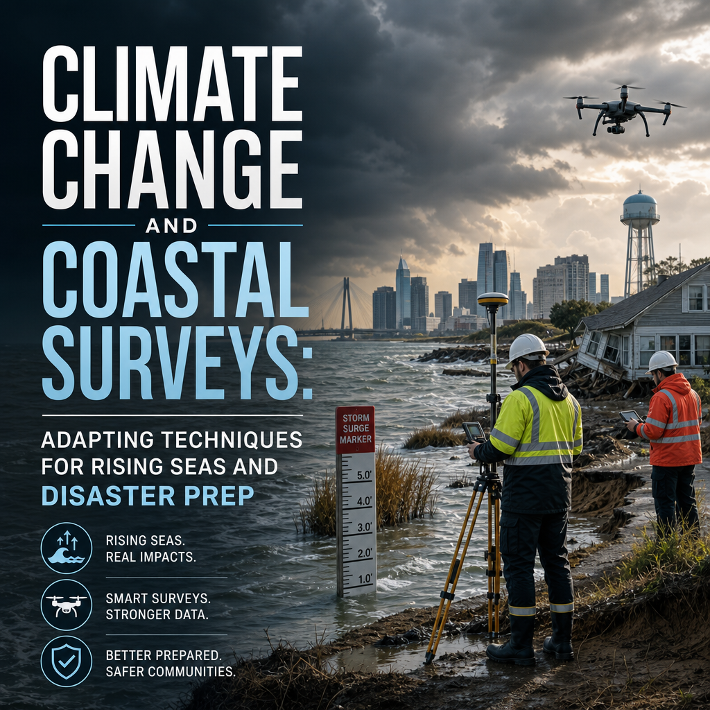
By 2026, global mean sea levels have risen approximately 20 centimetres above pre-industrial baselines — and the rate of rise is accelerating. For the millions of people living within a few metres of the shoreline, that number is not an abstract statistic. It is a direct threat to their homes, businesses, and livelihoods. The discipline of climate change and coastal surveys: adapting techniques for rising seas and disaster prep has never been more urgent, more technically demanding, or more consequential for the built environment.
Surveyors, engineers, planners, and property owners are all grappling with the same fundamental question: how do traditional survey methods hold up when the ground — and the water around it — refuses to stay still?
Key Takeaways 📌
- Sea level rise and increased storm frequency are forcing a complete rethink of how coastal surveys are planned, executed, and interpreted.
- Advanced technologies — including drone-based LiDAR, satellite InSAR, and real-time IoT sensors — are becoming standard tools in the resilient surveyor's toolkit.
- Structural vulnerability assessments of coastal buildings must now account for dynamic environmental baselines, not static historical data.
- Regulatory compliance around flood risk, environmental impact, and disaster preparedness is tightening across the UK and globally.
- Early, proactive surveying of at-risk properties is the single most cost-effective step owners can take before a climate-related event occurs.
How Climate Change Is Reshaping Coastal Survey Demands
The relationship between climate change and coastal surveys: adapting techniques for rising seas and disaster prep begins with understanding what has fundamentally changed about the coastal environment itself.
The Shifting Baseline Problem
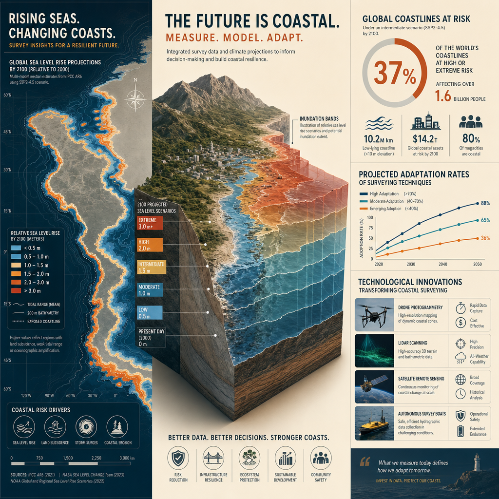
Historically, surveyors worked from stable reference points. Ordnance Survey benchmarks, fixed tide gauges, and historical flood records provided reliable baselines for measuring land levels, structural integrity, and flood risk. Climate change has destabilised all three.
- Tidal baselines are shifting as mean sea levels rise
- Storm surge records are being broken with increasing regularity
- Coastal erosion rates have accelerated dramatically in many UK regions
- Ground subsidence is compounding sea level rise in low-lying areas like East Anglia and the Thames Estuary
💬 "A survey conducted on a coastal property using data from ten years ago may now be dangerously out of date — not because the survey was wrong, but because the environment has changed around it."
This shifting baseline means that any structural or building survey on a coastal or flood-prone property must now incorporate dynamic environmental data alongside traditional physical inspection. For those considering a property purchase near the coast, a Level 3 building survey is no longer a luxury — it is a minimum standard of due diligence.
Increased Frequency of Extreme Weather Events
The UK has experienced a marked increase in named storms, coastal flooding events, and tidal surges since 2000. Each event leaves behind structural damage that may not be immediately visible:
| Type of Damage | Visible? | Survey Method Required |
|---|---|---|
| Foundation scour | ❌ Hidden | Ground-penetrating radar / structural survey |
| Wall saturation & damp | ⚠️ Partially | Damp survey |
| Roof damage from storm debris | ✅ Visible | Roof survey |
| Subsidence from soil saturation | ❌ Hidden | Subsidence survey |
| Floor slab heave or cracking | ⚠️ Partially | Solid floor slab survey |
Each of these damage types requires a specialist survey approach — and in a post-storm coastal environment, multiple defects often occur simultaneously.
Modern Techniques Transforming Coastal and Flood-Risk Surveying
The evolution of climate change and coastal surveys: adapting techniques for rising seas and disaster prep is being driven by technology. Several innovations have moved from experimental to essential in the past decade.
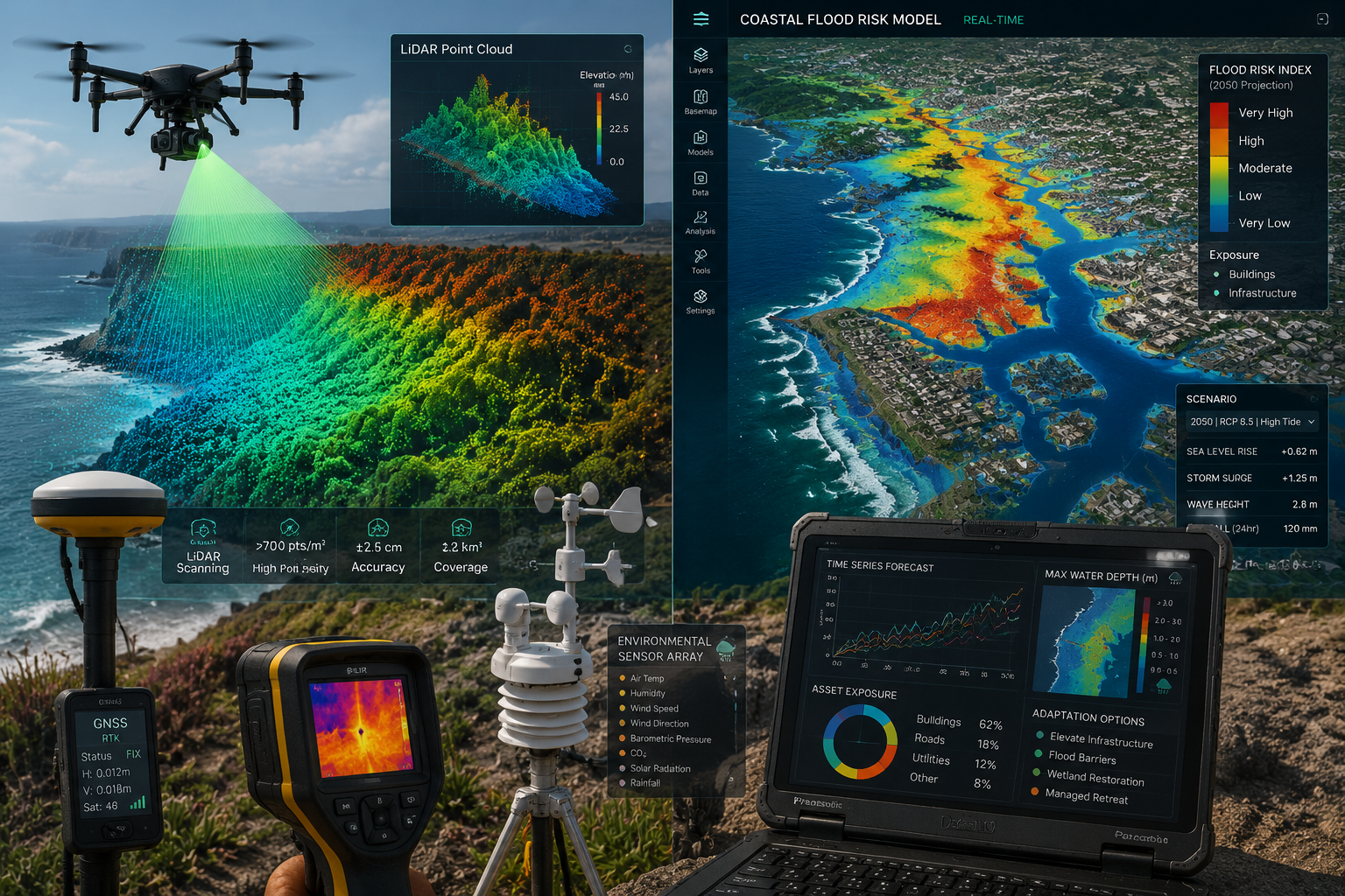
🚁 Drone-Based LiDAR and Photogrammetry
Unmanned aerial vehicles (UAVs) equipped with Light Detection and Ranging (LiDAR) sensors can produce millimetre-accurate 3D point clouds of coastal terrain in a fraction of the time required by traditional ground survey methods. This matters enormously in coastal contexts because:
- Surveyors can map inaccessible cliff faces, eroding dunes, and intertidal zones without physical risk
- Repeat drone surveys at regular intervals produce change-detection models that quantify erosion rates
- Post-storm damage assessments can be completed safely and rapidly
For property owners and developers, drone surveys are increasingly the first line of assessment for large coastal sites, providing data that feeds directly into structural and planning decisions.
📡 Satellite InSAR (Interferometric Synthetic Aperture Radar)
InSAR technology uses satellite radar to detect ground movement at sub-centimetre precision across wide areas. For coastal survey applications, it enables:
- Long-term subsidence monitoring of coastal settlements
- Detection of differential settlement in coastal infrastructure
- Identification of landslide precursors on coastal cliffs
This technology is particularly valuable for commercial property owners and local authorities managing large portfolios of coastal assets. A commercial building survey in a high-risk coastal zone should now routinely incorporate InSAR baseline data.
🌊 Real-Time IoT Sensor Networks
The deployment of Internet of Things (IoT) sensors in vulnerable coastal structures represents a paradigm shift from periodic inspection to continuous monitoring. These systems can track:
- Structural vibration and movement in real time
- Moisture ingress levels within walls and foundations
- Tidal and groundwater levels relative to structural elements
- Temperature-driven expansion and contraction cycles
When sensor data triggers threshold alerts, surveyors can respond proactively rather than reactively — a critical advantage in disaster preparedness planning.
Ground-Penetrating Radar (GPR) and Geophysical Surveys
Coastal foundations are uniquely vulnerable. Salt water accelerates corrosion of reinforcing steel; wave action causes scour beneath footings; repeated wetting and drying cycles degrade concrete. GPR surveys allow surveyors to assess subsurface conditions without excavation, identifying:
- Voids beneath foundations caused by scour or erosion
- Rebar corrosion in reinforced concrete structures
- Buried drainage or service failures that may be contributing to instability
For properties showing signs of movement, a subsidence survey combined with GPR investigation provides the most complete picture of what is happening below ground.
Environmental Compliance and Disaster Preparedness Strategies
Beyond the technical tools themselves, climate change and coastal surveys: adapting techniques for rising seas and disaster prep demands a new approach to regulatory compliance, risk communication, and pre-disaster planning.
The Evolving UK Regulatory Landscape
The UK's planning and building regulations are adapting — though not always fast enough — to the realities of climate risk. Key frameworks affecting coastal surveys in 2026 include:
🏛️ National Planning Policy Framework (NPPF)
The NPPF requires that development in flood-risk areas be supported by a Flood Risk Assessment (FRA). Surveyors working on coastal properties must understand how FRA requirements interact with structural survey findings.
📋 Environment Agency Flood Maps
These are updated regularly and should be consulted as a baseline for any coastal property survey. However, surveyors should treat them as a minimum threshold — local topography, drainage conditions, and climate projections may indicate higher risk than the maps suggest.
🌿 Biodiversity Net Gain Requirements
Coastal development and remediation projects must now demonstrate biodiversity net gain. This intersects with survey work through the need to assess existing ecological value before any intervention.
Pre-Disaster Survey Protocols: What Best Practice Looks Like
The most resilient coastal communities and property owners share a common trait: they survey before disaster strikes, not after. A robust pre-disaster survey protocol includes:
-
Baseline structural survey — establishing current condition as a documented reference point. A full structural survey provides the comprehensive baseline needed for insurance and legal purposes.
-
Schedule of condition — a photographic and descriptive record of the property's state at a specific point in time. This is invaluable for insurance claims and legal disputes following a storm event.
-
Flood risk-specific assessment — identifying the specific vulnerabilities of the property to tidal flooding, surface water flooding, and groundwater rise.
-
Insurance reinstatement valuation — ensuring that the property is insured for the correct rebuild cost, accounting for the additional complexity and expense of coastal construction. An insurance reinstatement valuation is essential for coastal properties where rebuild costs can be significantly higher than standard.
-
Repeat monitoring programme — scheduling regular follow-up surveys at defined intervals, with drone or sensor data feeding into a long-term condition record.
Communicating Risk to Property Owners
One of the most underappreciated skills in modern coastal surveying is risk communication. Surveyors must translate complex technical findings — sea level rise projections, structural vulnerability indices, flood return period probabilities — into clear, actionable guidance for property owners who may have no technical background.
💬 "The best coastal survey report is one that a property owner can read, understand, and act upon — not one that impresses other surveyors with its technical vocabulary."
This means survey reports for coastal properties should include:
- Plain-language executive summaries of key risks
- Prioritised action lists with cost estimates where possible
- Clear timelines for recommended interventions
- Signposting to relevant specialists — structural engineers, flood risk consultants, planning advisors
For homeowners navigating the complexity of survey reports, understanding what surveyors look for in a house survey provides valuable context for interpreting findings in a coastal risk context.
Building Resilience: Practical Steps for Coastal Property Owners and Developers
The intersection of climate change and coastal surveys: adapting techniques for rising seas and disaster prep ultimately comes down to practical action. Here is a framework for different stakeholders:
For Residential Property Owners 🏠
| Priority | Action | Survey Type |
|---|---|---|
| High | Assess current structural condition | Building survey |
| High | Check for existing damp or moisture ingress | Damp survey |
| Medium | Document current condition for insurance | Schedule of condition |
| Medium | Verify insurance reinstatement value | Insurance valuation |
| Ongoing | Monitor for subsidence or movement | Structural monitoring |
For Developers and Commercial Owners 🏗️
- Commission site-specific flood risk assessments before any coastal development
- Integrate drone survey data into site planning from the earliest stage
- Ensure structural surveys account for marine exposure conditions (salt air, wave action, humidity)
- Build monitoring programmes into long-term asset management plans
- Engage with local authority coastal management strategies to understand planned interventions
For Local Authorities and Emergency Planners 🚨
- Maintain up-to-date baseline surveys of critical coastal infrastructure
- Use GIS-integrated survey data to model evacuation routes and shelter-in-place options
- Develop post-disaster survey protocols so that damage assessment can begin immediately after an event
- Invest in community resilience programmes that help private property owners understand and act on their coastal risk
Conclusion: Surveying for a Coast That Won't Stay Still
The coastline has always been a dynamic environment. What has changed in 2026 is the pace and predictability of that dynamism. Rising seas, intensifying storms, and accelerating erosion are compressing the timescales within which property owners, surveyors, and planners must respond.
Climate change and coastal surveys: adapting techniques for rising seas and disaster prep is not a niche specialism for a handful of experts. It is rapidly becoming a core competency for the entire surveying profession — and a critical knowledge area for anyone who owns, manages, or plans to purchase property near the coast.
Actionable Next Steps ✅
- If you own a coastal property: Commission a comprehensive building or structural survey now, before the next storm season. Establish a documented baseline.
- If you are buying a coastal property: Insist on a Level 3 survey that explicitly addresses flood risk, coastal erosion, and marine exposure conditions.
- If you manage commercial coastal assets: Implement a continuous monitoring programme using IoT sensors and schedule annual drone surveys for change detection.
- If you are a surveyor: Invest in training for drone operation, LiDAR data interpretation, and flood risk assessment. These skills are no longer optional.
- If you are a planner or emergency manager: Integrate current survey data into disaster preparedness plans and update them at least every two years.
The coast will keep changing. The surveyors — and property owners — who adapt their techniques to match that change will be the ones who protect what matters most.