
The UK construction sector generates roughly 62% of the country's total waste output, yet the environmental assessment tools used in property development have historically lagged far behind the scale of that impact. That gap is closing fast. In 2026, sustainable surveying practices: using tech to assess environmental impacts in property development have moved from a niche specialism into a mainstream professional obligation — driven by tighter regulations, growing client demand, and a new generation of digital tools capable of capturing ecological data with unprecedented accuracy.
This article examines the technologies reshaping how surveyors measure, model, and report on environmental risk, and explains why these methods matter for developers, buyers, and the wider planning system.
Key Takeaways
- Advanced tools including drones, LiDAR, ground-penetrating radar, and AI-powered platforms now allow surveyors to collect detailed ecological data with minimal site disturbance.
- Stricter UK environmental compliance requirements in 2026 make tech-enabled Environmental Impact Assessments (EIAs) essential, not optional.
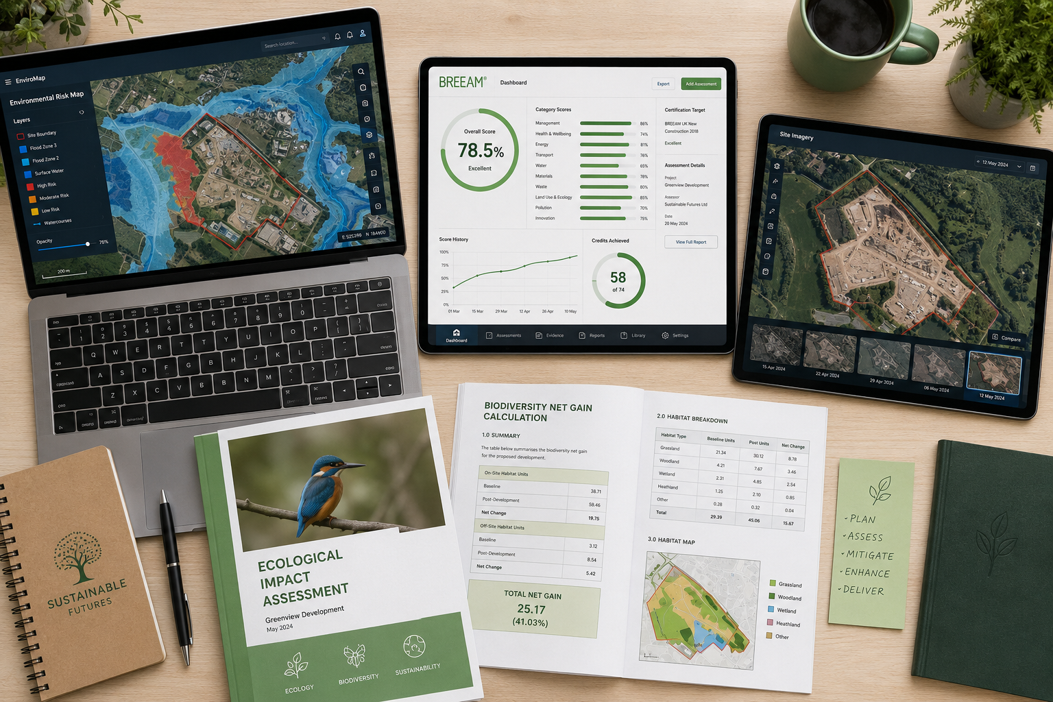
- Environmental risk mapping platforms such as Groundsure consolidate flood, contamination, and biodiversity data into single risk profiles.
- Green rating frameworks like BREEAM and NABERS UK are increasingly integrated into the surveying process, going beyond standard Energy Performance Certificates.
- The Royal Institution of Chartered Surveyors (RICS) now formally advocates for sustainability to be embedded across the full asset lifecycle.
Why Environmental Assessment Has Become Central to Property Surveying
Property development has always carried environmental consequences. What has changed is the legal and professional weight now attached to measuring those consequences accurately. The UK's updated Environmental Impact Assessment regulations, reinforced in 2026, require developers to demonstrate not just that harm will be minimised, but that biodiversity net gain will be achieved [1]. This shift has placed surveyors at the centre of the compliance process.
The Royal Institution of Chartered Surveyors (RICS) has formalised this position, publishing updated guidance that explicitly advocates for sustainability considerations — environmental, social, and economic — to be embedded across the entire asset lifecycle [5]. For surveyors, this means environmental data collection is no longer an add-on to a standard inspection. It is a core deliverable.
Understanding what surveyors look for during a property assessment has always included structural integrity, drainage, and material condition. Today, it also includes soil contamination risk, ecological sensitivity, flood vulnerability, and carbon performance. For a detailed overview of what a thorough inspection covers, see this complete guide to what surveyors look for in a house survey.
The regulatory pressure is real. Developers who fail to produce credible environmental assessments face planning refusals, enforcement action, and reputational damage. Tech-enabled surveying reduces that risk by producing data that is both more accurate and more defensible in front of planning authorities.
The Core Technologies Driving Sustainable Surveying Practices
Drones and Aerial Data Capture
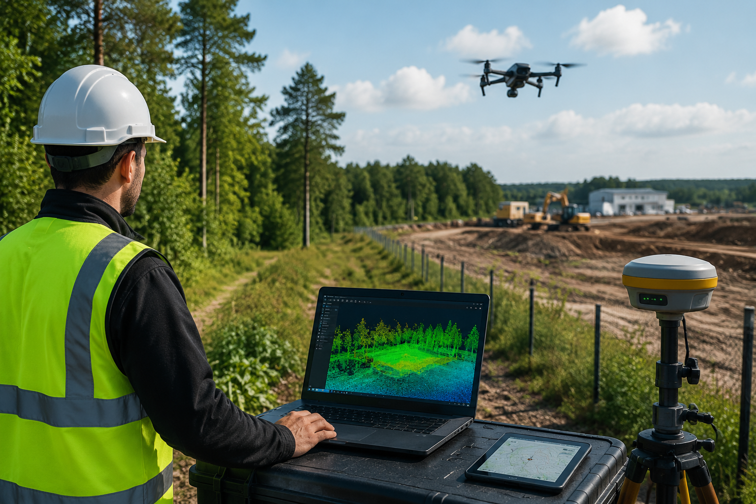
Unmanned aerial vehicles (UAVs) have transformed site assessment. A drone can survey several hectares in a single flight, capturing high-resolution imagery and thermal data that would take a ground team days to collect manually. Crucially, this approach minimises physical disturbance to vegetation, soil, and wildlife habitats — a significant advantage when working near protected ecological zones [4].
Thermal imaging drones can identify heat loss patterns in existing structures, locate underground water courses, and detect subsurface anomalies without any excavation. For commercial property assessments, this capability is particularly valuable. Surveyors carrying out commercial building surveys increasingly use drone data to supplement ground-level inspections, especially on large or complex sites.
LiDAR and Ground-Penetrating Radar
LiDAR (Light Detection and Ranging) uses laser pulses to create precise three-dimensional models of terrain and structures. In an environmental context, these models reveal topographic features that affect drainage patterns, erosion risk, and flood behaviour — data that is critical for responsible site planning [1].
Ground-penetrating radar (GPR) complements LiDAR by examining what lies beneath the surface. GPR can detect buried contamination, underground storage tanks, historic foundations, and subterranean water courses without a single test pit being dug [1]. For brownfield redevelopment — one of the UK government's priority development categories — this combination of surface and subsurface mapping provides a comprehensive environmental baseline before any planning application is submitted.
Subsidence risk is one area where this technology delivers particular value. Surveyors conducting subsidence surveys can use GPR data to identify void formation and soil instability that traditional visual inspection would miss entirely.
Remote Sensing and Satellite Imagery
Satellite data allows surveyors to analyse decades of land-use history for a given site. Changes in vegetation cover, drainage patterns, and land classification are all visible in archived satellite imagery, providing context that no single site visit can replicate [1].
This historical perspective is especially important for ecological impact assessments. If a site was previously industrial, satellite records may reveal contamination migration pathways that are not apparent from current ground conditions. Hydrological modelling — predicting how a proposed development will affect water flow across a wider catchment — also relies heavily on satellite-derived topographic data [6].
Mobile Mapping Systems and Indoor 3D Surveys
Mobile mapping systems (MMS), including indoor mobile mapping systems (iMMS), have significantly improved the efficiency of building-level environmental assessments. These systems capture detailed 3D point clouds of both interior and exterior spaces in a single pass, reducing the number of site visits required and therefore minimising carbon emissions associated with the survey process itself [2].
For asset managers and developers assessing existing building stock for retrofit or redevelopment, iMMS data provides the geometric accuracy needed to calculate insulation requirements, identify thermal bridges, and model energy performance improvements with confidence.
"The most sustainable survey is one that collects the most useful data with the least environmental disruption — and mobile mapping technology is making that possible at scale."
Environmental Risk Mapping and Green Certification Frameworks
Risk Mapping Platforms
One of the most practical advances in sustainable surveying has been the development of environmental risk mapping platforms. Tools such as Groundsure and Landmark Information Group aggregate multiple datasets — flood risk zones, contaminated land registers, radon mapping, ecological designations, and planning history — into a single, layered risk profile [3].
This consolidation matters because environmental risks rarely exist in isolation. A site with moderate flood risk may also sit adjacent to a Site of Special Scientific Interest (SSSI), which changes both the planning constraints and the mitigation measures required. Risk mapping platforms allow surveyors to identify these overlapping constraints early, before significant design investment has been made.
| Environmental Data Layer | Relevance to Development |
|---|---|
| Flood risk zones | Site layout, drainage design, insurance |
| Contaminated land | Remediation costs, planning conditions |
| Ecological designations | Biodiversity net gain obligations |
| Radon potential | Building specification, health compliance |
| Hydrological mapping | Surface water management, run-off modelling |
| Historic land use | Contamination pathways, archaeological risk |
BREEAM, NABERS UK, and Beyond EPCs
Energy Performance Certificates (EPCs) have long been the standard measure of a building's energy efficiency. However, EPCs assess theoretical performance based on design specifications, not actual operational energy use. In 2026, surveyors are increasingly expected to be familiar with frameworks that measure real-world performance [3].
BREEAM (Building Research Establishment Environmental Assessment Method) provides a holistic rating covering energy, water, materials, ecology, and wellbeing. A BREEAM assessment during the surveying phase allows developers to identify where a proposed scheme falls short of target ratings before construction begins — a far cheaper point at which to make design changes.
NABERS UK (National Australian Built Environment Rating System, adapted for the UK market) focuses on operational performance, making it particularly relevant for commercial landlords and institutional investors who need to demonstrate ongoing sustainability credentials to tenants and funders.
For property buyers and developers seeking a thorough understanding of building condition as a foundation for any sustainability upgrade programme, a Level 3 Building Survey provides the detailed structural baseline from which environmental improvement plans can be built.
Ecological Impact Assessments
Ecological Impact Assessments (EcIAs) have become a standard requirement for any development affecting land with ecological value. A well-executed EcIA goes beyond a simple species survey. It incorporates biodiversity data, soil health analysis, hydrological mapping, and habitat connectivity modelling to produce a comprehensive picture of ecological function on and around a site [6].
The data feeding into an EcIA now comes from multiple technological sources: drone surveys for canopy cover and habitat extent, soil sensors for carbon content and compaction, and eDNA (environmental DNA) sampling for aquatic species detection. Together, these inputs produce biodiversity net gain calculations that satisfy the mandatory 10% net gain requirement introduced under the Environment Act 2021.

Sustainable Surveying Practices in Commercial and Residential Contexts
Commercial Property
Commercial developments face the most rigorous environmental scrutiny. Large-scale schemes typically require full EIAs, biodiversity net gain plans, sustainable drainage system (SuDS) designs, and carbon assessments. The surveying phase is where the data underpinning all of these documents is gathered.
Tech-enabled sustainable surveying practices: using tech to assess environmental impacts in property development are particularly valuable in the commercial sector because the cost of getting environmental assessments wrong — through planning delays, remediation requirements, or legal challenge — is proportionally much higher. A single contamination discovery late in the development process can add millions to project costs.
Damp surveys are another area where technology is changing outcomes. Moisture mapping using thermal imaging and capacitance sensors can identify damp penetration pathways across an entire building envelope in a fraction of the time required by traditional probe-based methods. For commercial landlords managing dilapidations claims, this data provides an objective, timestamped record of building condition. Learn more about dilapidations surveys and how they intersect with building condition assessments.
Residential Property
For residential buyers, the environmental dimension of surveying is increasingly relevant. Flood risk, ground contamination from former industrial use, and proximity to ecological designations all affect both the insurability and the long-term value of a property.
A comprehensive condition survey report now routinely incorporates environmental risk data alongside structural findings. For buyers purchasing in areas with known environmental sensitivities, this integration of data is essential. The comprehensive condition survey reports available from qualified chartered surveyors reflect this broader scope of assessment.
New build buyers face a slightly different set of considerations. While new buildings are designed to current environmental standards, the site they occupy may carry legacy contamination or ecological constraints that affect the long-term performance of sustainable drainage and landscaping features. Commissioning an independent survey — even on a new build — is a sensible precaution. For more on this, see the complete guide to surveys on new builds.
Challenges and the Path Forward
Data Integration and Standardisation
The proliferation of environmental data sources creates its own challenge: integration. Drone imagery, LiDAR point clouds, satellite data, soil sensor readings, and risk platform outputs are generated in different formats by different systems. Surveyors must be able to synthesise these inputs into coherent, actionable reports — a skill that requires both technical literacy and professional judgement.
AI-powered platforms are beginning to address this challenge by automating the processing of large datasets and flagging anomalies for human review. However, the professional responsibility for interpreting and communicating environmental risk remains with the qualified surveyor [1].
Skills and Training
The adoption of sustainable surveying practices: using tech to assess environmental impacts in property development requires ongoing professional development. RICS has responded by incorporating sustainability competencies into its assessment of professional competence, meaning that newly qualified surveyors are expected to demonstrate environmental literacy as a baseline skill [5].
For clients, this means it is worth verifying that the surveyor they engage has current knowledge of environmental assessment technologies and frameworks — not just traditional building inspection skills.
Reducing the Carbon Footprint of Surveying Itself
There is a productive irony in ensuring that the process of assessing environmental impact is itself conducted sustainably. Mobile mapping and drone technology directly reduce the number of site visits required, cutting travel emissions. Single-visit data capture replaces multiple inspection rounds. Digital reporting eliminates paper. These operational improvements are not incidental — they are part of the broader commitment to sustainable practice that RICS and the wider profession now expect [4][7].
Conclusion
The convergence of drone technology, LiDAR, remote sensing, AI analytics, and environmental risk mapping has fundamentally changed what is possible in property surveying. Sustainable surveying practices: using tech to assess environmental impacts in property development are no longer the preserve of large infrastructure projects. They are becoming standard practice across commercial and residential development in the UK, driven by regulatory obligation, client expectation, and the professional standards set by RICS.
Actionable next steps for developers, buyers, and property professionals:
- Commission surveys from chartered surveyors with demonstrable competency in environmental assessment technologies and current RICS sustainability guidance.
- Request that environmental risk mapping data — covering flood, contamination, and ecological constraints — is included as a standard deliverable in any pre-acquisition or pre-planning survey.
- For commercial developments, engage with BREEAM or NABERS UK assessors at the earliest design stage, using survey data as the baseline for green rating targets.
- For residential buyers in areas with known environmental sensitivities, specify a Level 3 Building Survey that incorporates thermal imaging and moisture mapping alongside structural assessment.
- Stay informed about biodiversity net gain obligations and ensure that any site-level ecological data collected during surveying is retained for use in planning submissions.
The tools exist. The regulatory framework is in place. The remaining variable is whether the professionals involved in property development choose to use them to their full potential.
References
[1] Sustainability Driven Surveying Using Tech To Assess Environmental Impacts – https://www.canterburysurveyors.com/blog/sustainability-driven-surveying-using-tech-to-assess-environmental-impacts/?utm_source=openai
[2] mdpi – https://www.mdpi.com/2076-3417/15/14/7638?utm_source=openai
[3] Sustainability In Property Surveying Tools For Eco Impact Assessment And Green Development – https://kingstonsurveyors.com/sustainability-in-property-surveying-tools-for-eco-impact-assessment-and-green-development/?utm_source=openai
[4] The Future Of Land Surveying Technology 2026 Trends In Mobile 3d Mapping And Gnss Rtk Systems – https://nottinghillsurveyors.com/blog/the-future-of-land-surveying-technology-2026-trends-in-mobile-3d-mapping-and-gnss-rtk-systems?utm_source=openai
[5] Sustainability Practice For Surveyors June 2026 – https://www.rics.org/content/dam/ricsglobal/documents/standards/Sustainability-practice-for-surveyors_June-2026.pdf?utm_source=openai
[6] Ecological Impact Assessments In Surveys Guiding Sustainable Land Development Beyond Basics – https://wimbledonsurveyors.com/ecological-impact-assessments-in-surveys-guiding-sustainable-land-development-beyond-basics/?utm_source=openai
[7] Sustainable Surveying Vancouver – https://measurebuilt.com/sustainable-surveying-vancouver?utm_source=openai