
}
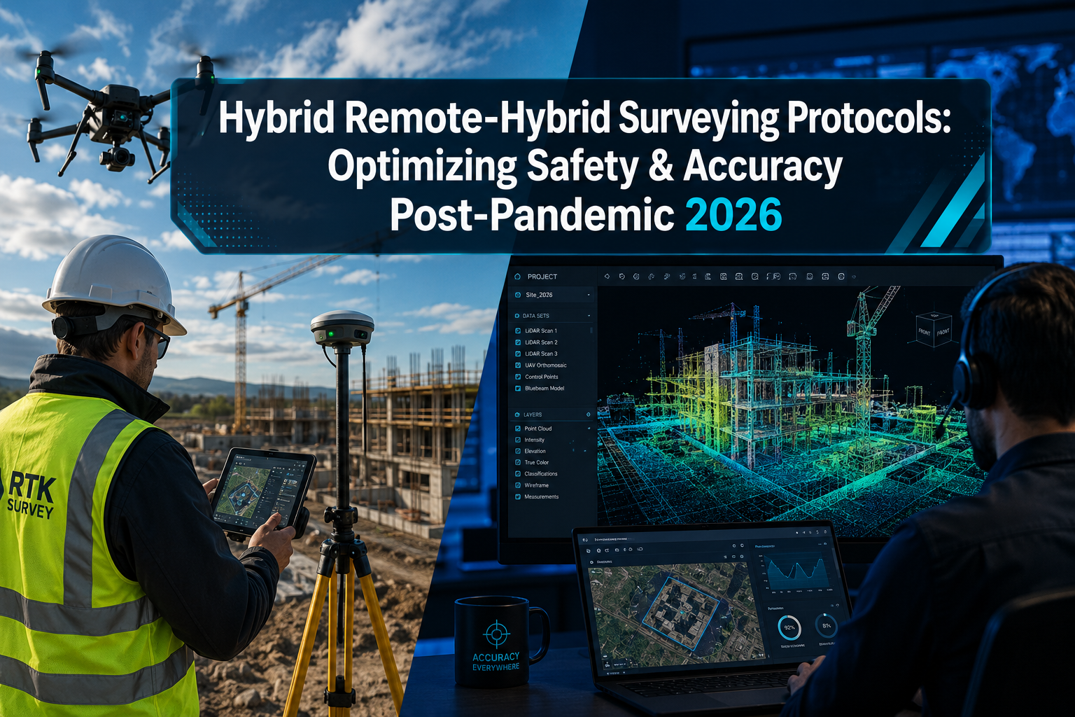
Fewer than 15% of surveying firms used any form of remote data collection before 2020. By 2026, that figure has inverted entirely, with hybrid remote-on-site models now representing the dominant operational framework across residential, commercial, and infrastructure surveying sectors. The shift was forced by necessity, but it has been refined by evidence. Hybrid Remote-Hybrid Surveying Protocols: Optimizing Safety and Accuracy Post-Pandemic in 2026 are no longer a workaround — they are the standard against which all modern surveying practice is measured.
This article outlines the core protocols that blend remote technology with minimal but targeted on-site validation. It draws on the latest adoption trends, accuracy benchmarks, and regulatory guidance to show how firms can cut operational costs without sacrificing the precision and legal defensibility that clients and regulators demand.
Key Takeaways
- Hybrid surveying protocols combine remote data acquisition (drones, LiDAR, GNSS) with selective on-site validation to reduce cost and field time without compromising accuracy.
- RTK and PPK GNSS workflows, when combined, deliver 3 cm 3D accuracy and are especially effective in large, complex, or remote sites [2][10].
- Australian hybrid LiDAR-ground workflows achieve vertical accuracies of plus or minus 30-50mm in open areas and plus or minus 50-100mm in vegetated zones, with significantly reduced field time [4].
- The ASPRS Edition 2 accuracy standards now reflect advances in sensor technology, relaxing some ground control requirements while maintaining rigorous output quality [5].
- Safety, legal defensibility, and client confidence all improve when hybrid protocols include documented on-site checkpoints and standardized remote assessment procedures.
The Post-Pandemic Shift: Why Hybrid Protocols Became the New Normal
The pandemic did not simply disrupt surveying — it exposed how fragile purely in-person workflows had always been. When site access was restricted, firms that had invested in digital infrastructure continued operating. Those that had not, stalled.
The lessons learned between 2020 and 2022 accelerated a transformation that might otherwise have taken a decade. Remote observational data collection was validated as methodologically sound in peer-reviewed research as early as 2024, with studies confirming that remote methods can produce results comparable to in-person collection when protocols are properly structured [6]. Hybrid methodologies also gained traction in scientific and professional training contexts, with post-pandemic literature emphasizing their role in maintaining operational continuity and quality [7].
In the property surveying world, this translated into a clear operational model: use remote and automated tools for data acquisition at scale, then deploy a small, skilled on-site team for targeted validation and verification. This is the essence of what Hybrid Remote-Hybrid Surveying Protocols: Optimizing Safety and Accuracy Post-Pandemic in 2026 represent in practice.
What Drives Adoption in 2026
Several converging forces explain why hybrid protocols have become the default:
- Cost pressure: Sending a full survey team to every site is expensive. Hybrid models reduce field time substantially, particularly on large sites [9].
- Safety obligations: Post-pandemic health and safety frameworks have raised the bar for risk assessments before any site visit. Remote-first approaches reduce unnecessary exposure.
- Technology maturity: Drone LiDAR, RTK/PPK GNSS, and cloud-based processing platforms have reached a level of reliability and affordability that makes hybrid workflows practical for firms of all sizes.
- Regulatory alignment: Standards bodies including ASPRS and PIC/S have updated their guidance to accommodate and formalize hybrid and remote assessment approaches [1][5].
For property buyers and owners, understanding how these protocols affect the surveys they commission is increasingly important. Whether considering a Level 2 homebuyer survey or a more detailed Level 3 building survey, the underlying data collection methods now often involve a hybrid of remote and on-site work.
Core Technical Components of Hybrid Surveying Protocols

The technical architecture of a well-designed hybrid protocol rests on three pillars: remote data acquisition, GNSS positioning accuracy, and on-site validation checkpoints. Each must be configured correctly for the protocol to deliver legally defensible, high-accuracy outputs.
RTK and PPK GNSS: The Accuracy Foundation
Real-Time Kinematic (RTK) and Post-Processed Kinematic (PPK) GNSS workflows are the backbone of modern hybrid surveying accuracy. RTK provides real-time corrections from a base station or network, making it ideal for sites with reliable connectivity. PPK processes corrections after data collection, offering greater resilience in areas with poor network coverage.
Combining both in a hybrid RTK-PPK workflow addresses the weaknesses of each method individually. This combined approach is particularly effective for:
- Large sites with uneven network coverage
- Corridor mapping projects (roads, pipelines, utilities)
- Dense urban environments with signal interference
- Remote areas lacking real-time correction services [2]
When properly executed, conventional, post-processed, and real-time GNSS methods can all deliver 3 cm 3D accuracy with high confidence [10]. The choice between them depends on site conditions, not on one method being inherently superior.
Drone LiDAR and Photogrammetry
Drone-mounted LiDAR sensors have transformed large-scale data acquisition. In hybrid workflows adopted across Australian infrastructure projects in early 2026, drone LiDAR combined with targeted ground surveying achieved:
| Environment | Vertical Accuracy |
|---|---|
| Open areas | Plus or minus 30-50mm |
| Vegetated regions | Plus or minus 50-100mm |
These figures represent a significant improvement over earlier drone-only approaches, achieved by integrating ground control points (GCPs) and traditional total station measurements at key validation locations [4]. Field time is reduced substantially compared to fully manual ground surveys, while accuracy remains within acceptable tolerances for most commercial and residential applications.
Seasonal and temporal data collection further enhances reliability. Research published in January 2026 demonstrated that seasonally structured drone surveys, anchored by RTK-GNSS control networks, produced highly precise shoreline change data across multiple survey cycles [3]. The principle applies directly to property and construction surveying: repeated hybrid surveys over time build a robust, defensible dataset.
The ASPRS Edition 2 Accuracy Standards
The American Society of Photogrammetry and Remote Sensing released Edition 2, Version 2 of its positional accuracy standards in June 2024. This update relaxed some requirements for ground control and checkpoint density, reflecting the improved accuracy of modern sensors and processing software [5]. The practical effect for hybrid protocols is meaningful: fewer physical ground control points are needed to meet accuracy thresholds, reducing on-site time without compromising output quality.
This does not mean GCPs can be eliminated. It means they can be deployed more strategically — concentrated at areas of high complexity or legal sensitivity rather than distributed uniformly across every survey area.
For surveyors working on complex residential or commercial properties, resources such as the complete guide to construction surveys and guidance on what surveyors look for in a house survey provide useful context on how these technical standards translate into practical inspection criteria.
Designing a Hybrid Protocol: Safety, Accuracy, and Legal Defensibility
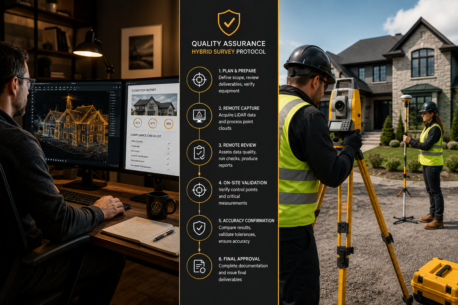
A hybrid protocol is only as strong as its weakest link. The most common failure point is not the technology — it is the absence of a clear, documented framework that governs when remote methods are sufficient and when on-site validation is mandatory.
The Minimal On-Site Validation Principle
The goal of Hybrid Remote-Hybrid Surveying Protocols: Optimizing Safety and Accuracy Post-Pandemic in 2026 is not to eliminate site visits. It is to make every site visit count. On-site time should be reserved for:
- Ground control point placement and measurement — Physical GCPs anchor remote data to real-world coordinates with legal precision.
- Condition verification — Remote imagery cannot reliably assess material condition, damp, or structural movement. A qualified surveyor must physically inspect areas flagged by remote analysis.
- Access-restricted areas — Roof voids, subfloor spaces, and areas obscured by vegetation require direct inspection.
- Legal boundary confirmation — Boundary disputes and party wall matters require on-site evidence that remote data alone cannot fully substantiate.
"Hybrid approaches offer optimized speed, cost, precision, safety, and legal defensibility, especially for large areas exceeding 700 acres." [9]
This principle aligns with how regulatory bodies are approaching remote assessments more broadly. The Pharmaceutical Inspection Co-operation Scheme (PIC/S) released formal guidance in January 2025 to standardize hybrid inspection frameworks, emphasizing inter-agency communication, reliance on shared data, and efficient use of inspection resources [1]. While this guidance applies to pharmaceutical manufacturing, its structural logic — remote assessment supported by targeted on-site verification — maps directly onto property and land surveying practice.
Safety Protocols for On-Site Validation Teams
Post-pandemic safety obligations have not disappeared. In 2026, hybrid protocols must incorporate:
- Pre-visit risk assessments documented and retained as part of the survey record
- Minimum team size policies for different site types (solo visits permitted only for low-risk, accessible residential properties)
- PPE requirements scaled to site hazards, not defaulted to pre-pandemic minimums
- Digital check-in and check-out systems that log surveyor location and expected return time
Research into hybrid user testing during the pandemic period demonstrated that clear disinfecting and safety procedures for on-site equipment use — particularly shared devices — significantly reduced risk without impeding workflow [8]. The same principle applies to shared survey equipment and vehicles in 2026.
Documentation and Quality Assurance
Every hybrid survey should produce a documented audit trail that includes:
- Remote data acquisition logs (flight paths, GNSS correction records, processing reports)
- On-site validation records (GCP measurements, condition notes, photographs)
- Accuracy assessment reports cross-referenced against ASPRS or equivalent standards
- A clear statement of methodology in the final survey report
This documentation is not bureaucratic overhead. It is the legal and professional foundation that makes hybrid outputs defensible in disputes, planning applications, and property transactions. For property owners navigating complex situations such as party wall disputes or subsidence investigations, the quality of this documentation can determine outcomes.
Practical Implementation: Matching Protocol to Project Type
Not every survey requires the same hybrid configuration. The table below provides a practical framework for matching protocol intensity to project type.
| Project Type | Remote Data Component | On-Site Validation Required | Accuracy Target |
|---|---|---|---|
| Residential homebuyer survey | Desktop review, satellite imagery | Full internal and external inspection | Condition-based, not metric |
| Topographic survey (large site) | Drone LiDAR, RTK-PPK GNSS | GCPs, boundary checks | Plus or minus 30-50mm vertical |
| Commercial building survey | Drone facade scan, thermal imaging | Structural and services inspection | Condition and metric |
| Party wall survey | Desktop review, existing drawings | On-site measurement and condition record | Metric and legal |
| Construction monitoring | Repeated drone surveys | Periodic ground truth checks | Plus or minus 30-50mm |
For residential property buyers, the question of whether a hybrid approach affects the value of their survey is addressed in detail in resources such as is a homebuyers survey worth it and do I need a home survey when buying a home. The short answer: hybrid data collection enhances efficiency but does not replace the professional judgment of a qualified chartered surveyor conducting a physical inspection.
For larger commercial projects, RICS commercial building surveys increasingly incorporate hybrid data layers to support more comprehensive condition assessments, particularly for large or complex building envelopes where drone facade scanning can cover areas that would otherwise require expensive access equipment.
Cost Implications
Hybrid protocols deliver measurable cost savings across multiple categories:
- Reduced field time: Drone LiDAR surveys cover ground in hours that would take days manually
- Smaller on-site teams: Targeted validation requires fewer personnel than full ground surveys
- Lower access costs: Aerial data acquisition eliminates much of the need for scaffolding, cherry pickers, and similar access equipment
- Faster reporting: Cloud-based processing platforms accelerate data analysis and report generation
These savings do not come at the expense of accuracy when protocols are correctly designed. The evidence from 2026 practice consistently shows that well-structured hybrid workflows match or exceed the accuracy of traditional methods for most project types [4][9].
Conclusion
Hybrid Remote-Hybrid Surveying Protocols: Optimizing Safety and Accuracy Post-Pandemic in 2026 represent a mature, evidence-based evolution of professional surveying practice. The technology is proven, the standards are updated, and the cost case is clear. What separates firms that benefit from this evolution from those that do not is the quality of their protocol design.
Actionable next steps for surveying professionals and property owners:
- Audit current workflows against ASPRS Edition 2 standards and identify where remote data acquisition can replace unnecessary site visits without compromising accuracy.
- Invest in RTK-PPK hybrid GNSS capability if drone mapping is part of your service offering — the accuracy gains and network resilience justify the cost.
- Document every hybrid survey with a full audit trail covering remote acquisition, on-site validation, and accuracy assessment. This is non-negotiable for legal defensibility.
- Match protocol intensity to project type using a structured decision framework rather than applying a one-size-fits-all approach.
- Review safety protocols annually to ensure they reflect current site conditions, team capabilities, and regulatory expectations.
For property owners, the practical takeaway is equally direct: ask your surveyor how they use hybrid methods, what on-site validation they conduct, and how their accuracy is documented. A qualified chartered surveyor will have clear answers to all three questions.
References
[1] Pharmaceutical Inspection Co-operation Scheme (PIC/S) Guidance on Remote Assessments – https://www.nsf.org/life-science-regulatory-news/pharmaceutical-inspection-co-operation-scheme-pic-s-guidance-on-remote-assessments?utm_source=openai
[2] Hybrid RTK-PPK Workflows Improving Reliability in Drone Mapping – https://gnss.ae/hybrid-rtk-ppk-workflows-improving-reliability-in-drone-mapping/?utm_source=openai
[3] Seasonal Drone Data for Shoreline Change Monitoring – https://www.nature.com/articles/s41597-025-06310-z?utm_source=openai
[4] Hybrid Workflow Drone LiDAR Ground Surveying – https://www.hrsurveyors.com.au/articles/hybrid-workflow-drone-lidar-ground-surveying/?utm_source=openai
[5] The ASPRS Positional Accuracy Standards Edition 2 – https://lidarmag.com/2023/10/06/the-asprs-positional-accuracy-standards-edition-2/?utm_source=openai
[6] Feasibility of Fully Remote Observational Data Collection – https://link.springer.com/article/10.1007/s11121-024-01706-6?utm_source=openai
[7] Hybrid Methodologies in Scientific Training – https://journals.sagepub.com/doi/10.1177/87564793231215768?utm_source=openai
[8] Organizing VR User Tests with Remote and Hybrid Setups – https://researchportal.tuni.fi/en/publications/there-is-always-a-way-organizing-vr-user-tests-with-remote-and-hy/?utm_source=openai
[9] Remote vs In-Person Land Surveyor – https://surveyslate.com/blog/remote-vs-in-person-land-surveyor/?utm_source=openai
[10] Conventional, Post-Processed, or Real-Time GNSS Workflows – https://geospatial.trimble.com/blog/geospatial/en-US/article/conventional-postprocessed-or-real-time?utm_source=openai