
A surveyor in 2019 needed a van full of equipment, a team of three, and two weeks to produce a measured building survey. In 2026, a single professional with a smartphone and a cloud subscription can do the same job in hours. That shift is not hype — it is the defining story of how reality capture goes mainstream: implementing user-friendly tools for faster survey deliverables in 2026 is reshaping the entire property and construction sector.
From mobile LiDAR apps running on consumer hardware to AI-powered cloud platforms that stitch point clouds in real time, the barriers to entry for high-accuracy spatial data have collapsed. For chartered surveyors, property professionals, and their clients, the implications are enormous — faster turnaround, richer data, and safer site conditions. This guide unpacks what is driving the change, which tools are leading the charge, and how firms can implement these technologies today.
Key Takeaways 📌
- Mobile devices with LiDAR sensors have made professional-grade reality capture accessible without specialist hardware investment.
- Cloud-based AI processing reduces point cloud registration and report generation from days to minutes.
- Real-time collaboration platforms allow surveyors, clients, and engineers to review and annotate data simultaneously from any location.
- Safety improvements are measurable — remote scanning reduces the need for surveyors to access hazardous areas in person.
- Faster deliverables are now a competitive differentiator; firms not adopting these tools risk being left behind by 2027.
Why Reality Capture Is No Longer a Specialist Luxury
For most of the 2010s, reality capture technology — encompassing 3D laser scanning, photogrammetry, and structured-light measurement — belonged to large engineering firms with six-figure equipment budgets. The hardware was expensive, the software was complex, and the learning curve was steep.
Three converging forces changed everything:
1. Consumer Hardware Crossed the Accuracy Threshold
Apple's integration of LiDAR sensors into the iPhone 12 Pro (2020) and subsequent models was a watershed moment. By 2026, multiple Android flagship devices also carry time-of-flight depth sensors capable of sub-centimetre accuracy at short range. Apps such as Matterport Capture, Polycam, and FARO's mobile suite now run on these devices, turning a phone most surveyors already carry into a capable scanning instrument.
"The smartphone in a surveyor's pocket is now the most disruptive piece of survey equipment ever made." — Common refrain at RICS Digital Futures conferences, 2024–2025.
2. Cloud AI Eliminated the Processing Bottleneck
Historically, the slow part was not the scan — it was the office. Registering hundreds of scan positions, cleaning noise, and producing a usable deliverable could take days of specialist processing time. Cloud platforms now handle this automatically. AI algorithms align scan positions, remove dynamic objects (people, vehicles), classify surfaces, and generate floor plans or BIM models with minimal human input.
3. Software Became Genuinely User-Friendly
Early point cloud software required months of training. Today's platforms use drag-and-drop workflows, guided capture modes, and plain-language reporting tools. A surveyor who has never touched a laser scanner can produce a professional deliverable within their first day of using a modern mobile capture app.
How Reality Capture Goes Mainstream: Implementing User-Friendly Tools for Faster Survey Deliverables in 2026
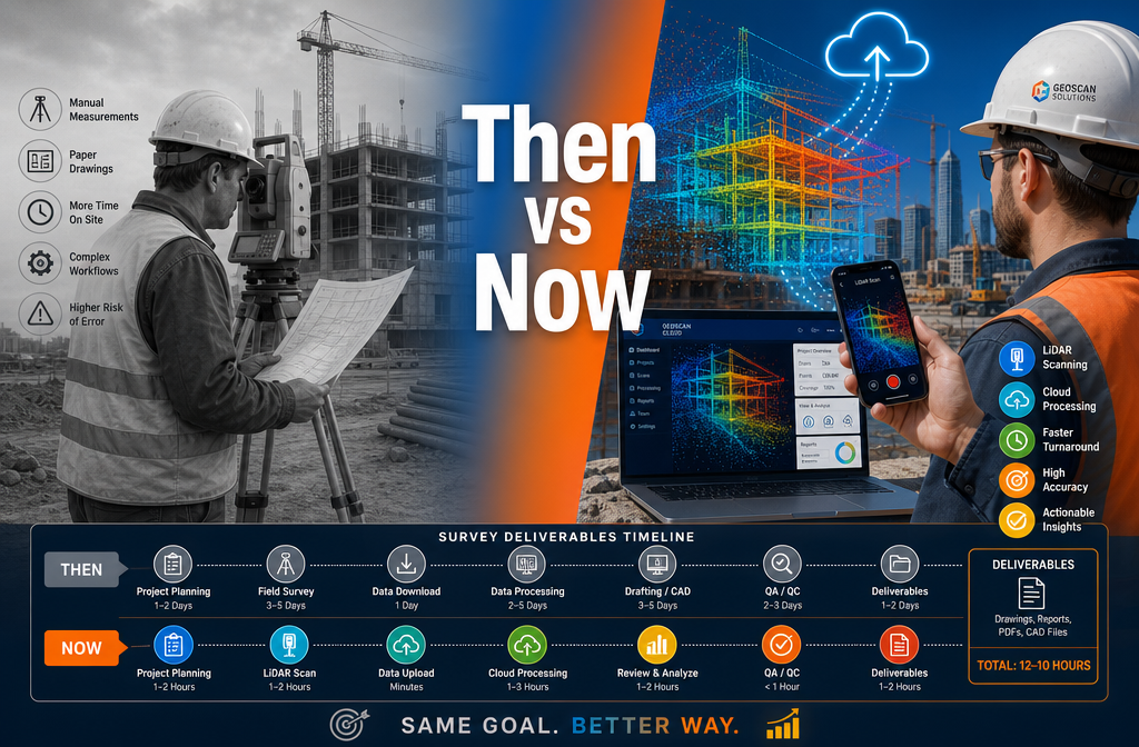
The practical implementation of mainstream reality capture follows a clear workflow. Understanding each stage helps firms identify where to invest and where existing processes can be enhanced rather than replaced.
Stage 1: Capture — Mobile-First Approaches
The capture stage is where accessibility has improved most dramatically. Three primary mobile approaches dominate in 2026:
| Method | Best For | Typical Accuracy | Hardware Cost |
|---|---|---|---|
| Smartphone LiDAR | Interior spaces up to 200 m² | ±5–10 mm | £0 (existing device) |
| Dedicated handheld scanner | Complex interiors, heritage buildings | ±2–3 mm | £3,000–£15,000 |
| Drone photogrammetry | Roofs, facades, large sites | ±10–20 mm | £1,500–£8,000 |
| 360° camera + AI processing | Condition surveys, walkthroughs | ±15–30 mm | £500–£3,000 |
For a standard building survey of a residential property, smartphone LiDAR combined with a 360° camera now covers the vast majority of data needs. Dedicated scanners remain valuable for heritage assets, complex geometry, or where legal accuracy thresholds apply.
Stage 2: Processing — Cloud AI in Real Time
Once captured, data uploads automatically to cloud platforms over 5G or Wi-Fi. Leading platforms in 2026 — including Matterport, Leica's JetStream Cloud, Trimble Connect, and Autodesk Forma — process raw scans into:
- ✅ Registered point clouds
- ✅ Textured 3D meshes
- ✅ Auto-generated floor plans with dimensions
- ✅ BIM-ready IFC files
- ✅ Condition-flagged inspection reports
Processing time for a typical three-bedroom house has dropped from 4–6 hours of manual work to under 15 minutes of automated cloud processing. This is the single biggest driver of faster survey deliverables.
Stage 3: Collaboration — Real-Time Multi-User Review
Perhaps the most underappreciated benefit of cloud-based reality capture is what happens after processing. Clients, engineers, architects, and surveyors can now access the same 3D model simultaneously, annotate defects, measure distances, and comment on specific areas — all without being in the same room or even the same country.
For firms offering dilapidation surveys or stock condition surveys, this collaborative layer transforms client relationships. Disputes about what was observed are resolved by returning to the immutable 3D record. Scope changes are documented in the model itself rather than in email chains.
Stage 4: Deliverables — Faster and Richer Than Ever
The end product of a modern reality capture workflow is significantly richer than a traditional survey report. Deliverables now routinely include:
- Interactive 3D walkthroughs accessible via web browser
- Annotated point clouds with hyperlinked defect notes
- Auto-dimensioned floor plans accurate to ±5 mm
- Condition heat maps colour-coded by severity
- Time-stamped photographic evidence embedded in the 3D model
For clients commissioning a comprehensive condition survey report, these richer deliverables provide far greater value than a PDF report alone.
Safety Improvements: The Underreported Benefit
The safety case for mobile reality capture is compelling and often overlooked in technology discussions. Consider the scenarios where traditional surveying carries genuine risk:
- Roof inspections requiring physical access to fragile or steep surfaces
- Basement and confined space surveys with poor air quality
- Partially demolished or structurally compromised buildings
- High-traffic commercial sites where surveyors must work around plant and vehicles
Drone-based photogrammetry and long-range handheld scanners allow surveyors to capture complete data on roofs and facades without ever leaving ground level. For roof surveys, this is transformative — a drone equipped with thermal imaging and a high-resolution camera can document every tile, flashing, and drainage outlet in 20 minutes, producing a georeferenced point cloud that supports the same analytical conclusions as a physical inspection, with zero fall risk.
The Health and Safety Executive (HSE) in the UK has consistently highlighted working at height as one of the leading causes of fatal injuries in construction. Any technology that reduces unnecessary access to elevated or unstable surfaces has a direct, measurable safety impact.
Implementing User-Friendly Tools: A Practical Roadmap for Survey Firms
Understanding the technology is one thing. Implementing it within an existing practice requires a structured approach. The following roadmap reflects best practice for firms of all sizes in 2026.
Step 1: Audit Current Workflows 🔍
Before purchasing any technology, map the current survey process from instruction to delivery. Identify:
- Where time is lost (typically: travel, manual measurement, report writing)
- Where errors most commonly occur (typically: transcription, dimensioning)
- Which deliverable formats clients most frequently request
Step 2: Start with Mobile LiDAR 📱
The lowest-risk entry point is a smartphone LiDAR app. Most leading apps offer free tiers or low-cost monthly subscriptions. Surveyors already carrying compatible devices can begin capturing data immediately. This builds familiarity with point cloud workflows before any significant capital investment.
Step 3: Integrate Cloud Processing 🌐
Once comfortable with capture, connect to a cloud processing platform. Evaluate platforms on:
- Processing speed for typical property sizes
- Output formats (does it produce what your clients need?)
- Collaboration features (can clients access and comment?)
- Integration with existing CAD or report-writing software
Step 4: Train for Interpretation, Not Just Operation 🎓
The biggest implementation risk is treating reality capture as a replacement for professional judgement. It is not. The technology captures data; the surveyor interprets it. Training should focus on:
- Understanding the limitations of each capture method
- Recognising artefacts and errors in point clouds
- Communicating 3D deliverables to clients unfamiliar with the format
For firms conducting RICS-specific defect surveys, maintaining professional standards while adopting new tools is non-negotiable. The technology accelerates data collection; RICS competency frameworks still govern how that data is analysed and reported.
Step 5: Communicate the Value to Clients 💬
Clients who have always received a PDF report may not immediately understand the value of an interactive 3D model. Proactive communication — demonstrating the deliverable format before instruction, offering a short walkthrough video — dramatically increases client satisfaction and repeat business.
Reality Capture Goes Mainstream: Implementing User-Friendly Tools for Faster Survey Deliverables in 2026 — Regional Considerations
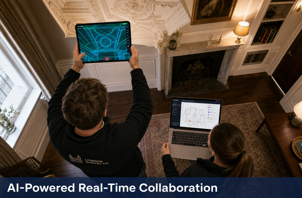
The adoption of reality capture tools is not uniform across all property types and geographies. In dense urban environments — where chartered surveyors in central London and chartered surveyors in North London frequently work with Victorian and Edwardian stock — the complexity of period architecture makes comprehensive 3D documentation especially valuable.
Heritage properties with ornate cornicing, irregular room shapes, and non-standard construction present challenges that traditional tape-and-sketch methods handle poorly. A point cloud captures every surface simultaneously, producing accurate as-built records that support everything from planning applications to insurance valuations.
In suburban and rural markets — where chartered surveyors in Berkshire and chartered surveyors in Buckinghamshire operate across large residential and commercial portfolios — drone photogrammetry adds particular value for large sites, agricultural buildings, and properties with extensive grounds.
Property Type Suitability at a Glance
| Property Type | Most Useful Capture Method | Key Deliverable Benefit |
|---|---|---|
| Victorian terraced house | Smartphone LiDAR + 360° camera | Accurate floor plans, defect documentation |
| Period commercial building | Handheld scanner | BIM-ready model, heritage record |
| Flat roof commercial unit | Drone thermal + photogrammetry | Defect mapping, drainage analysis |
| Large residential estate | Drone + ground-based LiDAR | Site plan, condition overview |
| Basement conversion | Handheld scanner | Structural geometry, headroom analysis |
The Competitive Landscape: Who Adopts Wins
The firms that will define the survey market in 2027 and beyond are those investing in reality capture capability now. The competitive advantages are concrete:
- Turnaround time: Firms using cloud AI processing are delivering reports 40–60% faster than traditional methods allow.
- Accuracy: Automated dimensioning eliminates human measurement error, reducing professional indemnity risk.
- Client experience: Interactive 3D deliverables command premium fees and generate stronger referrals.
- Capacity: Faster per-survey processing means the same team can handle a larger instruction volume.
For clients wondering whether a Level 3 survey is worth it, the answer in 2026 is increasingly yes — partly because reality capture tools make the most comprehensive survey types faster and more affordable to deliver than they were even three years ago.
Common Implementation Challenges and How to Overcome Them
No technology adoption is without friction. The most common challenges firms encounter when implementing reality capture tools include:
📶 Connectivity on site: Cloud-dependent workflows require data upload. Solution: most platforms support offline capture with automatic sync when connectivity is restored.
🔋 Device battery life: Intensive LiDAR scanning drains smartphone batteries quickly. Solution: carry portable power banks; consider dedicated scanning devices for full-day projects.
🔒 Data security and client confidentiality: Property data stored in cloud platforms raises legitimate questions. Solution: select platforms with ISO 27001 certification, EU/UK data residency options, and clear data retention policies.
📐 Accuracy expectations: Clients and legal teams may question whether mobile LiDAR meets accuracy requirements for specific purposes. Solution: always document the capture method and its stated accuracy in the survey report; use dedicated scanners where higher accuracy is required.
👥 Team resistance to change: Experienced surveyors may be sceptical of new tools. Solution: involve senior team members in pilot projects; focus training on how the tools support rather than replace professional expertise.
Conclusion: Act Now or Fall Behind
The mainstream arrival of reality capture is not a future event — it is happening across the UK property sector right now in 2026. The tools are accessible, the workflows are proven, and the client demand for faster, richer deliverables is only growing.
Actionable Next Steps for Survey Professionals:
- This week: Download a free LiDAR scanning app and scan a room in your own office. Understand what the data looks like before committing to any platform.
- This month: Trial a cloud processing platform on a live instruction. Compare the output quality and turnaround time against your current workflow.
- This quarter: Develop a client communication template that explains interactive 3D deliverables and their benefits. Use it on your next three instructions.
- This year: Invest in drone photogrammetry capability — either in-house or through a trusted subcontractor — to extend your service offering to roofs and large sites.
- Ongoing: Stay current with RICS guidance on digital survey methods to ensure all technology-enhanced work meets professional standards.
The surveyors who embrace reality capture goes mainstream: implementing user-friendly tools for faster survey deliverables in 2026 as a strategic priority — not a distant ambition — will define the next decade of the profession. The technology is ready. The only remaining question is whether your firm is.
