
Land prices surged 77% per acre between early 2019 and March 2026 — yet many property owners are still leaving thousands of pounds on the table simply because their land boundaries are unclear, undocumented, or disputed [3]. In a market this competitive, understanding how accurate land surveys boost property value: boundaries, development potential, and market edge is no longer optional — it is a strategic financial decision.
Whether buying, selling, or developing, a precise land survey is one of the highest-return investments a property owner can make. It removes uncertainty, unlocks development potential, and gives sellers a measurable edge over comparable listings.
Key Takeaways 📌
- Accurate boundary surveys eliminate costly disputes and protect property value before they erode it.
- The 2026 ALTA/NSPS standards raise the bar for survey precision, making compliant surveys more trusted by lenders, buyers, and title insurers [1].
- Zoning and setback clarity revealed by surveys can unlock significant development potential that adds direct value.
- Buyers pay more for certainty — a clean, current survey reduces perceived risk and supports higher offers.
- Survey costs are modest relative to the value gains and legal costs they prevent [2].
Why Boundary Clarity Is the Foundation of Property Value
Every property's value starts with one basic question: exactly what land does the owner actually own? Without a clear answer, every other valuation metric — price per square foot, development capacity, comparable sales — rests on shaky ground.
The Real Cost of Boundary Uncertainty
Boundary disputes are among the most expensive and time-consuming property conflicts in the UK and internationally. Legal battles over unclear lines can cost tens of thousands in solicitor fees, delay sales for months, and permanently damage relationships with neighbours. More critically, they suppress market value — buyers discount properties with unresolved boundary questions, and lenders may refuse to finance them altogether.
A professional boundary survey resolves this uncertainty with legal-grade precision. It establishes exactly where one property ends and another begins, using physical markers, title deeds, historical records, and modern GPS technology.
💬 "Uncertainty is the enemy of value. A precise boundary survey converts risk into a known quantity — and known quantities are always priced higher than unknowns."
What the 2026 ALTA/NSPS Standards Change
The updated Minimum Standard Detail Requirements for ALTA/NSPS Land Title Surveys, which took effect on February 23, 2026, now govern all ALTA/NSPS surveys begun on or after that date [1]. These are the baseline standards relied upon by purchasers, lenders, and title insurers for higher-value transactions.
Key changes in the 2026 revision include:
- Relative positional precision is now the accepted indicator of measurement quality, typically estimated via a properly weighted least-squares adjustment — pushing the industry toward more consistent, defensible accuracy [1].
- Surveyors must now document encroachments into setbacks and other critical areas, not just across lot lines. A building encroaching into a setback can reduce development options, complicate planning variances, or force costly remediation [1].
- Surveyors are specifically required to record their opinions on third-party uses of the property without recorded easements, and on access that exists only through common ownership with an adjacent parcel [1].
These changes make a current, compliant survey far more valuable to buyers and lenders than an older one. Institutional lenders and title insurers effectively require ALTA/NSPS-compliant surveys for higher-value transactions, meaning a fresh 2026-standard survey can improve financing options and ease of closing — directly supporting both value and liquidity [1].
Boundary Surveys and Neighbour Relations
Clear boundaries also prevent the slow erosion of value caused by informal encroachments — a fence built a metre too far, a shared driveway assumed to be private, or a garden wall that straddles the legal line. These issues, if left unaddressed, can become legally complex. Understanding party wall disputes and how to resolve them is closely related to boundary clarity, as many party wall conflicts stem directly from imprecise boundary records.
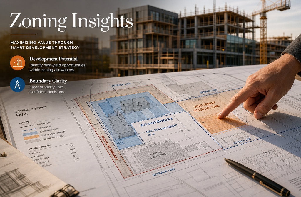
How Accurate Land Surveys Boost Property Value Through Development Potential
Understanding how accurate land surveys boost property value: boundaries, development potential, and market edge goes beyond simply knowing where the fence line sits. Surveys reveal what can legally and practically be built — and that development potential is often where the biggest value gains hide.
Unlocking the Hidden Value in Your Land
A detailed survey provides critical data that feeds directly into development feasibility:
| Survey Data Point | Development Impact |
|---|---|
| Exact lot dimensions | Determines maximum building footprint |
| Setback lines | Defines buildable area within the plot |
| Easements and rights of way | Identifies restrictions on use |
| Topographic data | Informs grading, drainage, and foundation costs |
| Zoning overlays | Confirms permitted uses and density |
| Encroachments | Flags issues before planning applications |
For example, a property owner who discovers through a survey that their plot is 8% larger than the title deed suggested — a surprisingly common finding — may be able to add an extension, a garden studio, or even a separate dwelling unit, depending on local planning rules. That additional buildable space can add tens of thousands to the property's market value.
Surveys and Planning Permission
Planning authorities rely heavily on accurate survey data when assessing applications. Submitting a planning application with imprecise site measurements is a common reason for delays or refusals. A current, accurate survey:
✅ Demonstrates professional due diligence to the planning authority
✅ Provides accurate site plans required for most applications
✅ Identifies constraints (flood zones, protected trees, easements) early
✅ Supports the case for variance or special use permits where needed
For complex projects, a construction survey provides the precise measurements needed to translate planning approval into actual building work, ensuring structures are placed exactly where they should be.
Commercial Properties: Even Higher Stakes
For commercial real estate, the value impact of accurate surveys is amplified. Investors and developers conducting due diligence on commercial sites require precise boundary data, easement information, and zoning confirmation before committing capital. Working with experienced commercial property surveyors ensures that all material facts about a site are documented, reducing risk for buyers and supporting higher valuations for sellers.
The global land surveying market is projected to grow significantly through the late 2020s, driven by increasing demand from real estate development, infrastructure projects, and the adoption of advanced technologies like LiDAR and drone-based surveying [6]. This growth reflects how central accurate survey data has become to property transactions at every level.

How Accurate Land Surveys Boost Property Value: Boundaries, Development Potential, and Market Edge in the Buyer's Eye
From a buyer's perspective, a property with a clean, current survey is simply a lower-risk investment. And in property markets, lower risk commands a premium.
The Psychology of Certainty in Property Transactions
Buyers — whether residential or commercial — make decisions based on perceived risk as much as on stated value. A property with documented, precise boundaries, no encroachments, and clear development rights signals:
- Professional ownership — the seller has managed the asset properly
- Fewer hidden surprises — due diligence is already partially done
- Easier financing — lenders are more comfortable with well-documented properties
- Faster closing — fewer title issues mean smoother conveyancing
This perception translates into tangible financial outcomes. Properties with clear documentation attract more competitive offers and spend less time on the market.
Survey Costs vs. Value Gains: The ROI Case
The cost of a professional land survey is modest relative to the value it protects and creates. According to recent data, land survey costs in 2026 vary by type and complexity, but a boundary survey for a standard residential property typically costs a fraction of what a boundary dispute would cost to resolve legally [2][5].
Consider this comparison:
| Scenario | Estimated Cost |
|---|---|
| Professional boundary survey | £500 – £2,000 (typical residential) |
| Boundary dispute legal fees | £5,000 – £50,000+ |
| Failed planning application (due to inaccurate data) | £2,000 – £10,000+ |
| Price reduction from buyer's perceived risk | 3% – 10% of property value |
The return on investment from a survey is not just about avoiding costs — it is about actively adding value by removing the discount buyers apply to uncertain properties.
What Buyers and Lenders Actually Look For
When a buyer's solicitor or lender reviews a property, they are looking for red flags. Common concerns include:
- 🚩 Boundaries that do not match the title register
- 🚩 Structures encroaching onto neighbouring land or into setbacks
- 🚩 Informal access arrangements without legal easements
- 🚩 Unregistered rights of way across the property
A current survey that addresses all of these — particularly one compliant with the 2026 ALTA/NSPS standards for higher-value transactions — removes these red flags before they become negotiating leverage for the buyer [1].
For homeowners who want to understand the full picture of their property's condition before selling or buying, a Level 3 building survey complements a land survey by providing a thorough structural assessment — together, they give the most complete picture of a property's true value.
Maximising Market Edge: Practical Steps for Property Owners
Here is how to use survey data strategically to maximise market edge:
Before selling:
- Commission a current boundary survey to confirm lot dimensions
- Resolve any encroachments or easement issues identified
- Document development potential (permitted extensions, additional units)
- Include survey documentation in the marketing pack
Before buying:
- Always commission an independent survey — never rely solely on the seller's documents
- Use survey findings to negotiate price adjustments for identified issues
- Assess development potential revealed by the survey against your investment thesis
- Confirm the survey meets current standards for lender acceptance
Before developing:
- Use survey data to maximise the buildable envelope within planning rules
- Identify and resolve any title issues before submitting planning applications
- Use topographic data to optimise site design and reduce construction costs
For buyers unsure about which type of survey is right for their situation, the guide to what survey you need is a helpful starting point before committing to a specific service.
The Role of RICS-Qualified Surveyors
Not all surveys are equal. The credentials and methodology of the surveyor matter enormously, particularly when survey findings will be relied upon by lenders, insurers, or in legal proceedings. RICS (Royal Institution of Chartered Surveyors) qualification is the benchmark for professional competence in the UK property market.
An RICS building survey provides a level of rigour and professional accountability that protects all parties in a transaction. When combined with accurate boundary data, it gives buyers and sellers the most defensible, comprehensive picture of a property's value.
Conclusion: Turn Survey Data Into Property Value
The connection between accurate land surveys and property value is direct, measurable, and increasingly important in 2026's competitive market. Boundary clarity eliminates the risk discounts buyers apply to uncertain properties. Development potential revealed by precise surveys unlocks value that would otherwise remain invisible. And the market edge gained from clean, current documentation attracts better offers, faster sales, and smoother financing.
The 2026 ALTA/NSPS standards have raised the bar for what "accurate" means — and properties supported by compliant, up-to-date surveys are simply better-positioned assets in any transaction [1].
Actionable Next Steps ✅
- Check when your property was last surveyed — if it was more than 5–10 years ago, or before the 2026 standards, consider commissioning an updated survey.
- Identify your goal — boundary confirmation, development planning, or pre-sale preparation each require slightly different survey types.
- Work with a qualified professional — use an RICS-accredited surveyor or one certified to the relevant national standards.
- Use the findings strategically — don't just file the survey; use it to resolve issues, inform planning, and strengthen your market position.
- Combine survey types for maximum insight — a boundary survey paired with a structural assessment gives the fullest picture of a property's value.
A survey is not an expense. It is one of the smartest investments a property owner can make.
References
[1] Nsps Land Title – https://www.parkerpoe.com/news/2026/02/key-takeaways-from-the-2026-alta/nsps-land-title
[2] Land Survey Costs In 2026 Price Trends Technologys Impact And Budget Planning For Property Owners – https://wimbledonsurveyors.com/land-survey-costs-in-2026-price-trends-technologys-impact-and-budget-planning-for-property-owners/
[3] Facebook (Realtor.com – Land Price Data) – https://www.facebook.com/realtor.com/posts/land-prices-surged-77-per-acre-between-early-2019-and-march-2026-while-inventory/1422550176584790/
[5] Blog Land Survey Costs 2026 – https://www.thelandgeek.com/blog-land-survey-costs-2026/
[6] Land Surveying Market 121553 – https://www.businessresearchinsights.com/market-reports/land-surveying-market-121553
