
Construction projects that use Building Information Modelling (BIM) report up to a 20% reduction in overall project costs — yet a significant portion of surveying firms still treat BIM as an optional upgrade rather than a core workflow. That gap is closing fast in 2026, and the firms that bridge it first are winning contracts, reducing errors, and delivering projects on time.
BIM Integration in Property Surveying: Streamlining Construction with 3D Modeling is no longer a niche specialism. It has become the backbone of modern infrastructure delivery, reshaping how surveyors capture data, how designers collaborate, and how construction teams build with precision. This guide covers everything you need to know — from the tools and workflows involved to the real benefits of clash detection, digital twins, and field-to-model connectivity.
Key Takeaways 📌
- BIM is now a core surveying deliverable, not an optional add-on — survey data feeds directly into living 3D models used throughout a project's lifecycle.
- Modern surveying instruments (total stations, GNSS receivers, 3D laser scanners) ship with BIM-ready export capabilities, drastically reducing manual conversion steps.
- Clash detection enabled by BIM can identify design conflicts before construction begins, saving significant time and money.
- BIM-to-field layout closes the loop between digital model and physical site, reducing stakeout errors and improving build accuracy.
- Digital twins — continuously updated 3D models — are becoming the standard output of survey-led BIM workflows in 2026.
What Is BIM and Why Does It Matter for Property Surveying?
Building Information Modelling (BIM) is a digital process for creating and managing information about a built asset. At its core, it produces a rich 3D model that contains not just geometry but data — materials, dimensions, structural properties, MEP (mechanical, electrical, plumbing) systems, and more.
For property surveyors, BIM represents a fundamental shift in role. Traditionally, surveyors delivered static 2D drawings or point-in-time 3D scans. Today, survey data serves as the live foundation of BIM environments that support planning, construction, and long-term asset management [1].
💬 "Surveyors are no longer just data collectors — they are the architects of the digital twin." — GIM International [5]
This shift matters because:
- Errors caught early in the model cost a fraction of what they cost on site
- Stakeholders share a single source of truth rather than working from conflicting drawings
- As-built accuracy improves when survey data feeds directly into the model rather than being reinterpreted from paper
For those considering a property transaction or construction project, understanding what a property surveyor does provides essential context for how BIM-enabled surveyors add value at every stage.
How BIM Integration in Property Surveying Works: From Field to Model
The Traditional vs. BIM-Enabled Workflow
| Stage | Traditional Approach | BIM-Integrated Approach |
|---|---|---|
| Data Capture | Manual measurements, 2D drawings | Laser scanning, GNSS, robotic total stations |
| Data Processing | Manual drafting, CAD conversion | Automated point cloud → BIM import |
| Design Coordination | Separate discipline drawings | Federated 3D model with clash detection |
| Site Layout | Paper drawings, manual stakeout | BIM-to-field coordinate transfer |
| Asset Management | Static record drawings | Live digital twin |
BIM-Ready Surveying Instruments 🛠️
Modern surveying hardware has evolved to make BIM integration seamless. Key instruments include:
Robotic Total Stations
These instruments are now built to export BIM-ready datasets and connect directly to platforms like AutoCAD, Revit, and DraftSight BIM modules. Linework and points captured in the field can be imported with minimal reformatting [2].
GNSS Receivers
Brands including Trimble, Leica, and Carlson market their receivers as "BIM-ready," feeding coordinates straight into Revit or AutoCAD workflows. This ties high-precision geospatial control directly into the 3D model [2].
3D Laser Scanners
Scanners produce dense point clouds that are routinely ingested into BIM software for architectural visualisation and structural analysis. This turns as-built surveys into rich, analysable 3D datasets rather than simple drawings [2].
For complex infrastructure projects, construction surveys form the essential foundation upon which BIM models are built and verified throughout the build process.
The Point Cloud to BIM Pipeline
The most common entry point for survey data into BIM is the point cloud. Here's how it works:
- 🔍 Scan — Laser scanner captures millions of data points across the site or structure
- 📁 Register — Individual scan positions are merged into a unified point cloud
- 🔄 Import — Point cloud is loaded into BIM software (Revit, ArchiCAD, Bentley)
- 🏗️ Model — Surveyors or BIM technicians trace geometry over the point cloud
- ✅ Validate — Model is checked against original survey data for accuracy
This pipeline is now supported by AI-assisted tools that can automatically classify terrain, identify structural elements, and generate preliminary surface models that feed straight into BIM and digital twin environments [1].
Key Benefits of BIM Integration in Property Surveying: Streamlining Construction with 3D Modeling
1. Clash Detection: Catching Problems Before They Cost Money 💰
One of the most compelling arguments for BIM integration is clash detection — the ability to identify conflicts between different building systems before construction begins.
Without BIM, a structural beam might only be discovered to conflict with a ductwork run when both are already installed on site. With a federated BIM model, that clash is flagged digitally, resolved in the model, and never built incorrectly in the first place.
Types of clashes BIM detects:
- Hard clashes — Two objects physically occupying the same space (e.g., a pipe running through a beam)
- Soft clashes — Objects too close together, violating clearance requirements
- Workflow clashes — Scheduling conflicts between trades
Research confirms that BIM-enabled clash detection significantly reduces rework costs and contributes to measurable improvements in project delivery timelines [10].
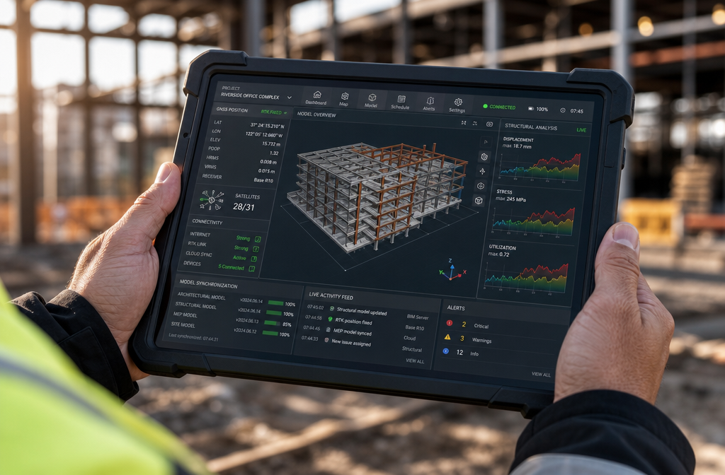
2. Real-Time Digital Twins 🔄
Surveying firms are now describing real-time digital twins as the premium output of BIM-integrated workflows. These are high-fidelity, interactive 3D models that update continuously as new data is collected from the site [1].
A digital twin is not just a snapshot — it is a living model that reflects current site conditions. As construction progresses, survey data updates the twin, giving project managers, engineers, and clients a continuously accurate picture of the build.
This is particularly valuable for:
- Monitoring structural movement during excavation or demolition
- Tracking construction progress against programme
- Supporting facilities management after handover
For projects involving structural concerns, monitoring surveys provide the precise, ongoing data that keeps digital twins accurate and reliable.
3. Improved Collaboration Across Disciplines
A federated BIM model becomes a single source of truth for all project stakeholders. Architects, structural engineers, MEP consultants, contractors, and surveyors all work from — and contribute to — the same model.
This eliminates the version-control chaos of multiple drawing sets and dramatically reduces the risk of one discipline working from outdated information. The RICS recognises BIM data as a critical tool in project controls, enabling more accurate cost forecasting, programme management, and risk assessment [6].
4. BIM-to-Field Layout: Closing the Loop 🎯
BIM-to-field workflows represent one of the most practical advances in survey-led construction. Rather than printing drawings and manually interpreting dimensions on site, surveyors use coordinates and geometry taken directly from the BIM model to stake out columns, walls, utilities, and property features [3].
This approach:
- ✅ Reduces interpretation errors from 2D drawings
- ✅ Improves consistency between design intent and physical construction
- ✅ Positions surveyors as critical integrators between virtual design and real-world layout
The result is a construction process where the model and the building stay in alignment from foundation to finish.
5. Better Condition Surveys and As-Built Records
BIM integration also transforms how condition surveys are documented and used. When a comprehensive condition survey report is captured using laser scanning and fed into a BIM environment, the result is a richly detailed, queryable record of the building's state at any given moment.
This is invaluable for:
- Dilapidations assessments at lease end
- Renovation planning where existing conditions must be precisely understood
- Insurance and valuation purposes requiring verified structural data
BIM Adoption in 2026: Where the Industry Stands
Adoption Forecasts and Drivers
BIM adoption has accelerated significantly, driven by government mandates, client demand, and the proven return on investment it delivers. In the UK, BIM Level 2 has been mandatory on centrally procured public projects since 2016, and the push toward BIM Level 3 (fully integrated, cloud-based collaboration) is gaining momentum in 2026 [7].
Key drivers of adoption in 2026 include:
| Driver | Impact |
|---|---|
| Government mandates | Baseline BIM requirement for public infrastructure |
| AI-assisted modelling | Faster point cloud processing and automatic feature extraction |
| Cloud collaboration platforms | Real-time model sharing across global teams |
| Client sophistication | Owners demanding digital asset records at handover |
| Insurance and risk management | BIM data reduces liability through better documentation |
The Evolving Role of the Surveyor
The surveyor's role within BIM workflows has expanded considerably. Where surveyors once handed off data to BIM technicians, many now maintain and manage living BIM models throughout a project's lifecycle [5].
This requires new skills:
- Proficiency in BIM authoring software (Revit, ArchiCAD, Bentley OpenBuildings)
- Understanding of IFC (Industry Foundation Classes) open data standards
- Ability to manage point cloud data and coordinate reference systems within BIM environments
- Knowledge of digital twin platforms and IoT sensor integration
The surveying profession is responding. Training programmes, RICS guidance, and specialist software certifications are all expanding to meet demand [9].
For property buyers and owners navigating complex structural assessments, a Level 3 building survey represents the most detailed inspection available — and increasingly, these surveys are being delivered with BIM-compatible outputs.
Implementing BIM Integration in Property Surveying: Practical Steps for Firms
Step-by-Step Implementation Roadmap
Getting started with BIM integration does not require a complete overnight transformation. A phased approach works best:
Phase 1 — Assess and Equip
- Audit existing hardware for BIM-readiness (total stations, GNSS, scanners)
- Identify BIM software that fits your project types (Revit for buildings, Civil 3D for infrastructure)
- Train key staff on point cloud processing and BIM import workflows
Phase 2 — Pilot Projects
- Select two or three projects to run BIM-integrated workflows alongside traditional methods
- Document time savings, error reductions, and client feedback
- Refine workflows based on real-world experience
Phase 3 — Standardise and Scale
- Develop firm-wide BIM standards (naming conventions, coordinate systems, level of detail requirements)
- Integrate BIM deliverables into standard project contracts and fee structures
- Build relationships with BIM-capable design and construction partners
Phase 4 — Digital Twin Capability
- Invest in platforms that support live data feeds from site sensors and GNSS
- Offer digital twin maintenance as a post-construction service
- Position the firm as a full-lifecycle data partner, not just a project-phase supplier
Common Pitfalls to Avoid ⚠️
- Skipping coordinate system alignment — BIM models and survey control must share a common coordinate reference system from day one
- Treating BIM as a drawing tool — BIM's value lies in its data richness, not just its 3D geometry
- Neglecting information management — A BIM model without a clear data management protocol quickly becomes unreliable
- Underestimating training needs — Software proficiency takes time; budget for it properly
For firms offering structural engineer reports, integrating BIM outputs into structural assessments creates a more defensible, data-rich deliverable that clients and insurers increasingly expect.
BIM and Specialist Surveying: Practical Applications
Party Wall and Boundary Disputes
BIM models provide precise, verifiable spatial data that can be invaluable in resolving boundary disputes or demonstrating compliance with party wall requirements. A 3D model showing exact wall positions, structural elements, and proposed works gives all parties — and any appointed surveyor — a clear, unambiguous reference.
Snagging and New Build Inspections
For new build properties, BIM-integrated snagging surveys compare the as-built condition against the design model, automatically flagging deviations. This is far more systematic than a manual walkthrough and produces a documented, model-referenced snagging list. Understanding snagging survey costs in the UK helps buyers and developers budget appropriately for this increasingly tech-enabled service.
Topographic and Infrastructure Surveys
Topographic surveys are among the most natural entry points for BIM integration. Survey data captured for a development site feeds directly into civil engineering BIM models, informing earthworks, drainage design, and utility routing. Accurate topographic survey costs should account for BIM-ready deliverable formats, which add value but may require additional processing time.
Conclusion: Actionable Next Steps for BIM-Ready Surveying
BIM Integration in Property Surveying: Streamlining Construction with 3D Modeling is not a future trend — it is the present standard for competitive, high-quality surveying practice in 2026. The firms and professionals who embrace it are delivering better outcomes: fewer construction errors, faster project delivery, richer asset records, and stronger client relationships.
Actionable Next Steps ✅
- Audit your current toolkit — Identify which instruments already support BIM-ready export and which need upgrading
- Invest in software training — Revit, AutoCAD Civil 3D, and point cloud processing tools are the core skill set
- Start with one BIM pilot project — Real-world experience accelerates learning faster than any course
- Update your service offering — Add BIM-compatible deliverables to proposals and fee schedules
- Partner strategically — Align with architects, engineers, and contractors who are already BIM-mature
- Stay current with RICS guidance — BIM standards and mandates continue to evolve; professional body updates are essential reading
The transition from static drawings to living, data-rich 3D models is the defining shift in surveying practice right now. The technology is accessible, the client demand is real, and the competitive advantage for early adopters is substantial. The question is not whether to integrate BIM — it is how quickly to do it well.
References
[1] Future Land Surveying 2026 – https://haller-blanchard.com/future-land-surveying-2026/
[2] Top Surveying Tools That Integrate With Bim – https://www.baselineequipment.com/top-surveying-tools-that-integrate-with-bim
[3] What Is Land Surveying – https://www.kelarpacific.com/what-is-land-surveying/
[4] 10095020.2021 – https://www.tandfonline.com/doi/full/10.1080/10095020.2021.1937336
[5] Bim A New Model For Surveyors – https://www.gim-international.com/content/article/bim-a-new-model-for-surveyors
[6] Global Understanding The Value Of Bim Data In Project Controls Webinar – https://www.rics.org/training-events/online-training/scheduled/global-understanding-the-value-of-bim-data-in-project-controls-webinar
[7] The Role Of Surveyors In Bim Transformation – https://www.geoweeknews.com/blogs/the-role-of-surveyors-in-bim-transformation
[9] How To Stay Competitive In The Age Of Land Survey Automation – https://www.mckissock.com/blog/land-surveyor/how-to-stay-competitive-in-the-age-of-land-survey-automation/
[10] S2405844023069050 – https://www.sciencedirect.com/science/article/pii/S2405844023069050