
Only 42% of companies globally disclosed climate adaptation and resilience plans in 2025 — yet regulators, investors, and communities are demanding far more. That gap represents both a crisis and an extraordinary opportunity for the surveying profession [2]. As environmental legislation tightens and climate-driven risks reshape land, property, and infrastructure, sustainability in surveying: using tech to assess environmental impacts and compliance has moved from a niche specialism to a core professional competency.
This article explores how modern surveying tools — from drone-mounted sensors to AI-powered geospatial platforms — are transforming ecological data capture, climate risk mapping, and regulatory compliance. Whether dealing with coastal erosion, biodiversity net gain obligations, or mandatory carbon disclosures, today's surveyors are on the front line of the sustainability transition.
Key Takeaways
- 🌍 91% of businesses now produce annual carbon accounts, driving new demand for surveyors with sustainability and environmental data expertise [1].
- 📡 Drone surveys, LiDAR, and AI platforms are the core technologies reshaping how ecological and climate data is captured and verified.
- 📋 New regulations — including the EU's CSRD, California's SB 253/261, and RICS's April 2026 climate risk standards — are creating compliance verification roles that surveyors are uniquely placed to fill [9].
- 💧 Water stress assessment and coastal management are emerging as critical surveying specialisms, with water-related climate costs projected to reach $265 billion annually by 2050 [2].
- 🌿 Biodiversity net gain requirements and ecological baseline surveys are now standard parts of planning and development workflows in the UK.
The Regulatory Landscape Driving Sustainability in Surveying
A New Era of Environmental Compliance
The rules have changed — and they have changed fast. Surveyors who once focused primarily on structural condition, valuation, or boundary disputes now operate within a dense web of environmental obligations. Understanding this regulatory context is essential for any firm aiming to remain competitive in 2026.
Key frameworks reshaping surveying practice include:
| Regulation / Standard | Scope | Impact on Surveyors |
|---|---|---|
| EU Corporate Sustainability Reporting Directive (CSRD) | EU-wide, large companies | Mandatory double materiality assessments; environmental data verification |
| California SB 253 & SB 261 | Large US-operating companies | Scope 1, 2 & 3 emissions disclosure; climate financial risk reporting |
| RICS Climate Risk Standards (April 2026) | Global RICS members | Mandatory climate scenario analysis in property evaluations |
| AASB S2 Climate-related Disclosures | Australia (Q2 2026 first cycle) | Two climate scenarios required; links to financial documents |
| UK Biodiversity Net Gain (BNG) | England, planning system | Ecological baseline surveys mandatory for most developments |
The CSRD, in particular, has created significant new demand for surveyors to verify environmental data across entire value chains [2]. Double materiality assessments — which require organisations to report both how sustainability issues affect the business and how the business affects the environment — rely on accurate, verified geospatial and ecological data. That is precisely what a skilled surveyor can provide.
"Surveyors are no longer just measuring land and buildings — they are measuring the environmental footprint of entire portfolios."
The Royal Institution of Chartered Surveyors (RICS) updated its global standards in early 2026, making climate scenario analysis a mandatory component of property evaluations [9]. This means that understanding what a chartered surveyor does now includes a working knowledge of climate risk modelling, emissions accounting, and ecological assessment.
Meanwhile, California's SB 253 and SB 261 legislation requires large companies to disclose Scope 1, 2, and 3 greenhouse gas emissions and climate-related financial risks — opening compliance verification as a new revenue stream for surveying firms with environmental expertise [1].
The Carbon Accounting Opportunity
With 91% of businesses now producing annual carbon accounts and 65% completing reporting within three months [1], the appetite for accurate, third-party verified environmental data has never been higher. Surveyors are well-positioned to fill this role, particularly for:
- Built environment carbon assessments (embodied carbon in buildings and infrastructure)
- Land use change analysis (carbon sequestration mapping)
- Supply chain geospatial verification (mapping and auditing supplier land use)
Firms that develop these capabilities early will gain a significant competitive advantage as reporting requirements become universal.
Core Technologies Powering Sustainable Surveying Practice
Drones and Remote Sensing: The Eyes of Environmental Assessment
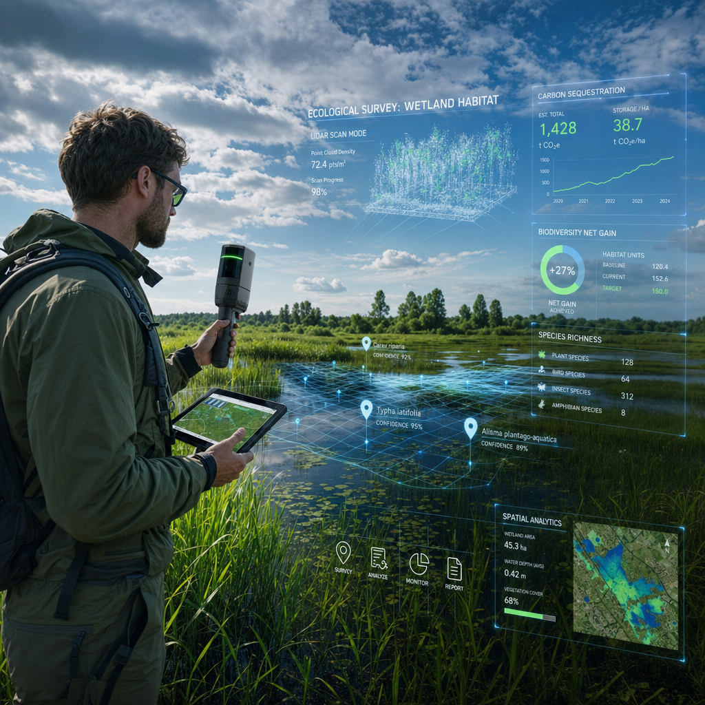
Unmanned Aerial Vehicles (UAVs) have fundamentally changed how ecological and topographic data is collected. Drone surveys can now cover large, difficult-to-access terrain — coastal cliffs, wetlands, forestry blocks — in a fraction of the time required by traditional ground-based methods.
What drones capture for sustainability assessments:
- 🌱 Vegetation health mapping using multispectral and near-infrared sensors (NDVI analysis)
- 🐦 Habitat and species distribution data for biodiversity net gain baseline surveys
- 🌊 Coastal erosion monitoring through repeat-flight photogrammetry and volumetric change analysis
- 🏗️ Construction site compliance — verifying that development stays within permitted ecological zones
- 💧 Flood risk and drainage mapping using high-resolution Digital Elevation Models (DEMs)
Paired with LiDAR (Light Detection and Ranging) technology, drones produce centimetre-accurate 3D point clouds that reveal ground-level topography even beneath dense vegetation. This is invaluable for hydrological modelling, subsidence risk assessment, and coastal management — areas where climate change is accelerating the pace of physical change.
For detailed topographic work, understanding the full scope of topographic survey costs is an important first step for project planning.
AI and Machine Learning: From Data to Decisions
AI-powered surveying tools are experiencing 32% year-over-year growth as firms adopt machine learning to analyse environmental data [2]. These platforms do not replace the surveyor's professional judgement — they dramatically accelerate it.
Key AI applications in environmental surveying:
- Automated change detection — comparing satellite or drone imagery across time periods to identify land use change, habitat loss, or coastal retreat
- Predictive flood modelling — using historical data and climate projections to forecast inundation risk under different warming scenarios
- Emissions mapping — integrating building energy performance data with geospatial layers to produce portfolio-level carbon risk maps
- Ecological classification — machine learning models trained to identify habitat types, invasive species, and biodiversity indicators from aerial imagery
⚠️ Important caveat: AI tools themselves carry an environmental cost. The energy and water demands of large-scale AI processing must be accounted for within sustainability assessments — a nuance that professional surveyors are increasingly required to flag [2].
Geospatial Platforms and GIS Integration
Geographic Information Systems (GIS) remain the backbone of environmental surveying. Modern cloud-based GIS platforms allow surveyors to:
- Layer climate risk data (flood zones, heat stress, subsidence risk) over property and land portfolios
- Conduct water stress assessments — critical given projections that water-related climate costs will reach $265 billion annually by 2050 [2]
- Map biodiversity net gain baselines and post-development outcomes using the UK's statutory Biodiversity Metric
- Verify supply chain environmental impacts using geospatial data — a growing need as businesses struggle with Scope 3 emissions reporting [1]
The integration of GIS with Building Information Modelling (BIM) is also enabling whole-lifecycle environmental assessments of construction projects, from groundworks through to demolition. This connects directly to construction survey best practices that increasingly incorporate environmental impact stages.
Groundwater and Hydrological Monitoring
Water stress is one of the most underappreciated dimensions of environmental risk in property and land surveying. Groundwater sampling and hydrological monitoring are becoming standard components of environmental baseline assessments, particularly for:
- Sites near rivers, floodplains, or coastal zones
- Brownfield and contaminated land redevelopment
- Agricultural land subject to irrigation stress
- Infrastructure projects in water-scarce regions
Surveyors who combine hydrological expertise with geospatial technology can offer clients a genuinely differentiated service — one that addresses regulatory compliance and long-term asset resilience simultaneously.
Sustainability in Surveying: Ecological Data, Coastal Management, and the Path to Compliance
Biodiversity Net Gain: A New Standard for Development Surveys
The mandatory Biodiversity Net Gain (BNG) requirement — now embedded in the UK planning system — has created a substantial new workload for ecological surveyors. Developers must demonstrate a minimum 10% net gain in biodiversity value compared to the pre-development baseline.
This requires:
- Pre-development ecological baseline surveys (habitat mapping, species surveys)
- BNG metric calculations using Natural England's statutory tool
- Post-development monitoring to verify that biodiversity gains are being delivered
- Habitat Management Plans to ensure long-term ecological outcomes
Drone-based habitat mapping, combined with AI-assisted species classification, is making these surveys faster and more repeatable. For complex sites, specific defect and condition assessments may also be required where existing structures interact with protected habitats.
Firms can also explore the growing market for biodiversity units — tradeable credits that allow developers to offset biodiversity losses off-site, creating a new financial instrument that surveyors are increasingly asked to value and verify.
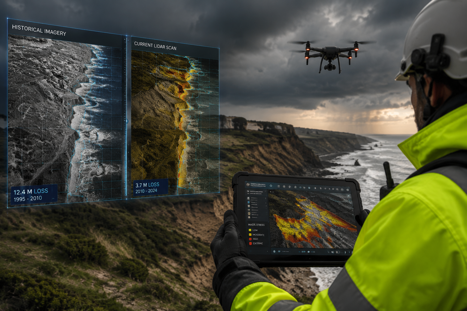
Coastal Management: Where Climate Risk Meets Surveying Expertise
Coastal surveying is perhaps the most vivid example of sustainability in surveying using tech to assess environmental impacts and compliance. Rising sea levels, increased storm intensity, and accelerating erosion are transforming the risk profile of coastal properties and infrastructure.
Technology tools for coastal management surveying:
| Tool | Application |
|---|---|
| Repeat-flight drone photogrammetry | Volumetric erosion measurement over time |
| Satellite-derived shoreline change analysis | Long-term coastal retreat mapping |
| LiDAR terrain modelling | Flood inundation scenario mapping |
| Hydrodynamic modelling software | Storm surge and wave run-up prediction |
| Ground-penetrating radar | Sub-surface geology and cliff stability assessment |
Surveyors working in coastal zones must now integrate climate scenario analysis — including at least two warming scenarios as required under AASB S2 and equivalent frameworks — into their assessments. This is no longer optional; it is a regulatory requirement for clients operating under mandatory climate disclosure regimes [8].
Closing the Adaptation Gap
Only 42% of companies globally disclosed adaptation and resilience plans in 2025 [2]. This is a striking gap — and it represents a direct opportunity for surveyors. Climate risk mapping, infrastructure resilience assessments, and scenario-based property valuations are all services that address this shortfall.
Surveyors working on commercial property portfolios, in particular, are finding that clients need help translating abstract climate projections into concrete, asset-level risk assessments. A coastal hotel, a riverside warehouse, or a floodplain housing development all require site-specific analysis that goes far beyond what generic climate datasets can provide.
The RICS sustainability agenda [9] makes clear that surveyors who can deliver this analysis — backed by robust technology and verified data — will be essential partners for clients navigating an increasingly complex regulatory and physical environment.
Practical Steps for Surveying Firms in 2026
For firms looking to build or strengthen their sustainability surveying capabilities, the following actions are recommended:
✅ Invest in drone and LiDAR capability — either in-house or through specialist sub-contractors with environmental data expertise
✅ Develop GIS and climate data literacy — ensure team members can interpret and communicate climate scenario outputs
✅ Understand BNG obligations — build ecological baseline survey capacity or partner with ecologists
✅ Engage with RICS sustainability standards — the April 2026 climate risk requirements apply to all RICS-registered valuers and surveyors [9]
✅ Offer hydrological and water stress assessments — a rapidly growing need that few generalist firms currently address
✅ Position as compliance verification partners — as CSRD, SB 253/261, and equivalent regulations expand, businesses need trusted third parties to verify environmental data [1][2]
Firms that combine traditional surveying expertise with modern environmental technology will be best placed to serve clients across residential, commercial, and infrastructure sectors. Understanding the full range of surveying specialisations available is a useful starting point for firms mapping their service development strategy.
Conclusion: The Surveyor as Environmental Guardian
Sustainability in surveying — using tech to assess environmental impacts and compliance — is not a future trend. It is the present reality of professional practice in 2026. The convergence of stricter regulation, climate-driven physical risk, and powerful new technologies has created both an urgent need and a genuine opportunity for the surveying profession.
Actionable next steps for surveyors and surveying firms:
- Audit current capabilities against the RICS April 2026 climate risk standards and identify skills gaps
- Invest in drone survey and GIS training to build in-house environmental data capacity
- Develop a BNG service offering — mandatory for most UK development projects and growing fast
- Build relationships with environmental scientists and ecologists to offer multidisciplinary assessments
- Market compliance verification services to businesses facing CSRD, SB 253/261, or equivalent disclosure obligations
- Stay current with RICS sustainability guidance at rics.org/sustainability
The surveying firms that thrive over the next decade will be those that embrace environmental technology not as an add-on, but as a core part of their professional identity. The planet — and the market — is asking for exactly this expertise.
References
[1] The State Of Sustainability In 2026 Progress Pressure And The Path Forward – https://www.sweep.net/blog/the-state-of-sustainability-in-2026-progress-pressure-and-the-path-forward
[2] 2026 Sustainability Trends – https://www.spglobal.com/sustainable1/en/insights/2026-sustainability-trends
[3] 2026 Corporate Sustainability Trends – https://eco-act.com/blog/2026-corporate-sustainability-trends/
[4] ESG Sustainability Survey 2025-26 – https://ivsc.org/esg-sustainability-survey-2025-26/
[5] ERM SI Annual Trends 2026 – https://www.erm.com/globalassets/insights/ermsi_annual_trends_2026.pdf
[6] Sustainability Trends For 2025 And Predictions For 2026 – https://instituteofsustainabilitystudies.com/insights/lexicon/sustainability-trends-for-2025-and-predictions-for-2026/
[7] 2026 State Of Supply Chain Sustainability Report – https://ctl.mit.edu/2026-state-supply-chain-sustainability-report
[8] AASB S2 Climate-related Disclosures (Watch) – https://www.youtube.com/watch?v=2xRUAI2HF0c
[9] Sustainability – RICS – https://www.rics.org/news-insights/current-topics-campaigns/sustainability
[10] Sustainability Trends Define 2026 And Years Beyond – https://www.linkedin.com/pulse/sustainability-trends-define-2026-years-beyond-tim-brppc