
By 2026, the gap between a traditional clipboard survey and a technology-enhanced building inspection has become impossible to ignore — and UK clients are starting to notice. A growing body of evidence from UK surveying practices shows that buyers who receive 3D models, drone imagery, and augmented reality walkthroughs alongside their reports make faster, more confident decisions than those handed a dense text document alone [1]. The shift in current trends in building surveying technology: from laser scanning and drones to AR walkthroughs for UK clients is no longer a future aspiration — it is a mainstream change reshaping how surveyors detect defects, communicate risk, and deliver value.

Key Takeaways 🔑
- Laser scanning now delivers millimetre-level accuracy and is increasingly the default for measured surveys on complex or heritage properties.
- Drones allow safe, detailed inspection of roofs, chimneys, and facades that would otherwise require costly scaffolding.
- Augmented reality (AR) walkthroughs are transforming how UK clients understand defects and prioritise repairs.
- AI-assisted analysis is accelerating defect detection and reducing human error in large data sets.
- Technology is primarily valuable when it improves client clarity and decision-making — not just data capture speed.
Why Technology Is Now Central to UK Building Surveys
For decades, a building survey meant a qualified surveyor walking a property with a damp meter, a torch, and a notepad. That model still has merit — but it has clear limits. Hard-to-reach roofs, complex heritage structures, and clients who struggle to interpret technical jargon all demand something better.
UK surveying firms are responding. According to ASG Consulting's 2026 practice update, residential building surveys are moving away from short narrative reports towards outputs that integrate laser measurements, drone imagery, and 3D models so buyers can see how a property "actually fits together" [1]. Bressummer Ark similarly notes that technology is now primarily used to improve clarity and decision-making for clients, rather than simply to speed up data capture [2].
This matters for surveyors at every level — from sole practitioners completing Level 2 homebuyer surveys to large firms handling complex RICS commercial building surveys.
💬 "The best technology in surveying is not the most expensive — it is the technology that helps a client understand what they are buying." — UK surveying industry consensus, 2026 [1]
Laser Scanning: The New Default for Measured Surveys
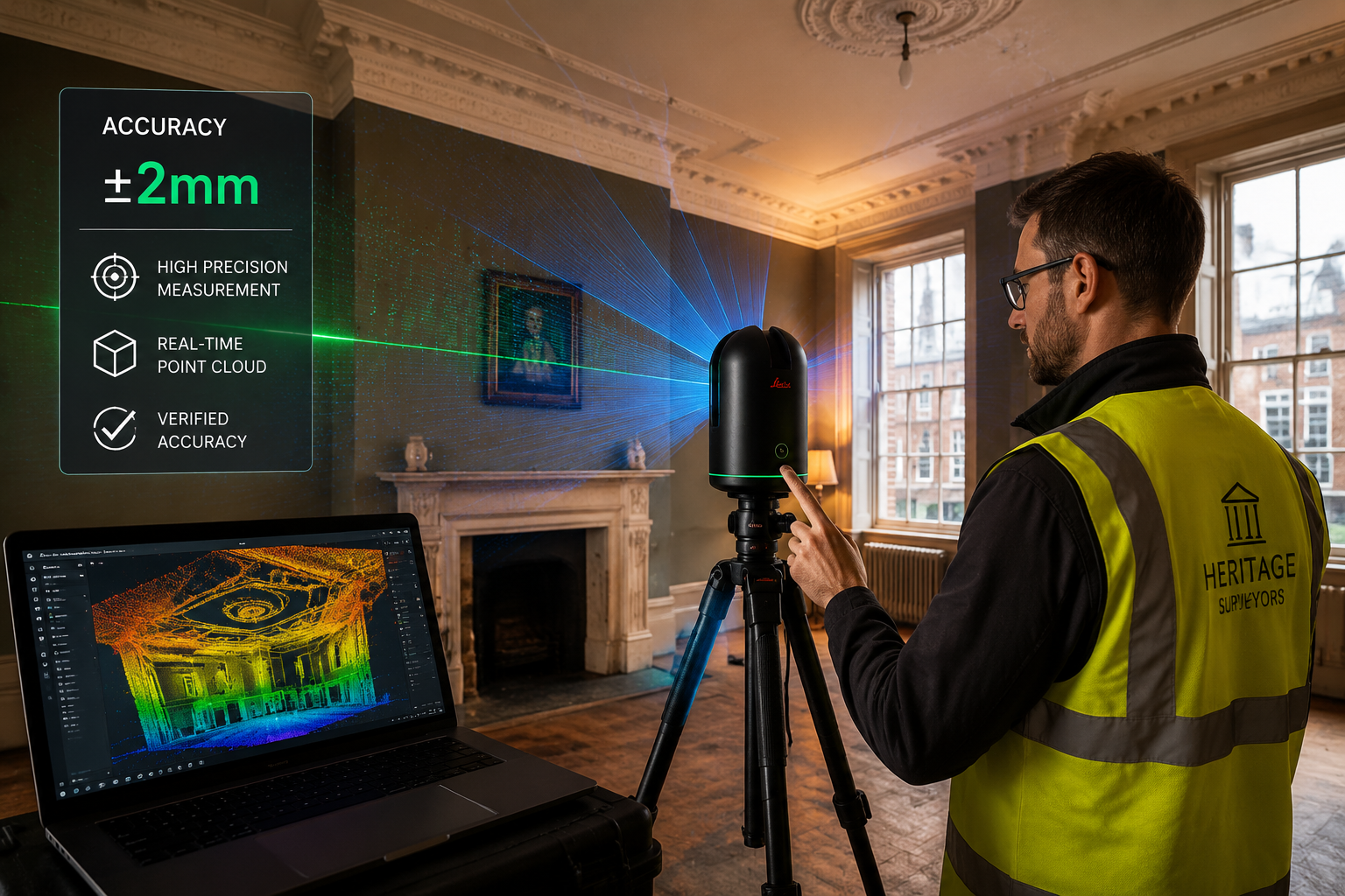
How 3D Laser Scanning Works
Terrestrial laser scanners — devices like the Leica BLK360 or FARO Focus — emit millions of laser pulses per second and record the precise distance to every surface they hit. The result is a point cloud: a dense, three-dimensional digital map of a building accurate to within 1–2 millimetres [3].
That point cloud can then be processed into:
- 2D floor plans and elevations for planning applications
- 3D BIM (Building Information Modelling) models for renovation projects
- Clash detection reports identifying where structural elements conflict
- Deformation analyses showing where walls or floors have moved over time
When Surveyors Should Deploy Laser Scanning
Laser scanning is not always necessary. The table below outlines when it adds clear value versus when simpler methods suffice:
| Scenario | Laser Scanning Recommended? | Why |
|---|---|---|
| Heritage or listed buildings | ✅ Yes | Captures complex geometry precisely |
| Large commercial properties | ✅ Yes | Reduces revisit time and human error |
| Standard 2-bed terrace | ⚠️ Sometimes | Cost may outweigh benefit |
| Structural deformation monitoring | ✅ Yes | Millimetre accuracy essential |
| Pre-purchase Level 3 survey | ✅ Often | Supports detailed defect mapping |
| Quick Level 2 survey | ❌ Rarely | Traditional methods usually sufficient |
Costs and Training Considerations
Entry-level laser scanners start at around £15,000–£25,000, with professional-grade units reaching £50,000+. Software licences for processing (e.g., Autodesk ReCap, Leica Cyclone) add further annual costs. For smaller firms, scanning-as-a-service providers offer a practical alternative.
Training typically requires 2–5 days of structured learning, plus hands-on practice to achieve reliable outputs. RICS and CIOB both offer CPD pathways covering geospatial technologies [9].
For surveyors carrying out monitoring surveys or subsidence surveys, laser scanning is rapidly becoming indispensable — offering a baseline record that can be compared against future scans to detect movement with precision [3].
Drones: Safe Access to Every Corner of a Building
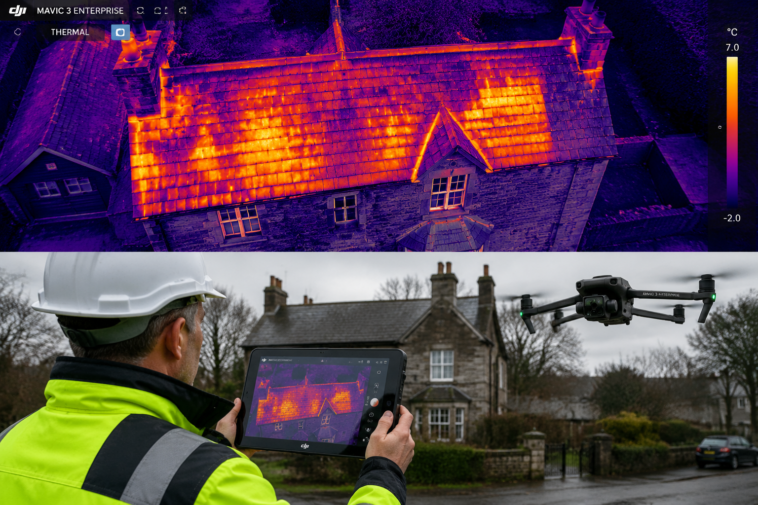
The Case for UAV Surveys
Roofs, chimneys, high parapets, and external facades above the first floor have always been a challenge. Traditional methods — binoculars, extending ladders, or expensive scaffolding — are slow, costly, and sometimes unsafe. Drones change that equation entirely.
A UAV (Unmanned Aerial Vehicle) survey can capture:
- High-resolution photography of roof coverings, flashings, and gutters
- Thermal imaging to identify heat loss, moisture ingress, and hidden defects
- Video walkthroughs of elevations for client-facing reports
- Photogrammetric models — 3D reconstructions of external envelope geometry
UK surveying firms report that drone inspections of a standard residential roof take 30–60 minutes, compared to half a day or more for scaffold access [7]. For roof surveys, this is a transformative efficiency gain.
Regulatory Framework in the UK 🇬🇧
Operating drones commercially in the UK requires compliance with Civil Aviation Authority (CAA) regulations. Key requirements include:
- GVC (General Visual Line of Sight Certificate) for most commercial survey operations
- Registration with the CAA as an operator
- Adherence to Operational Authorisation conditions, particularly near built-up areas
- Public liability insurance (minimum £1 million recommended)
Surveyors should also be aware of no-fly zones around airports and sensitive sites. The CAA's NATS drone app provides real-time airspace information.
Thermal Imaging: A Hidden Defect Detector
Thermal cameras attached to drones — or handheld for internal use — detect temperature differentials invisible to the naked eye. In practice, this means:
- Damp patches behind plasterwork show as cool zones
- Missing insulation appears as warm patches on external walls
- Electrical hotspots in plant rooms flag potential fire risks
- Flat roof membrane failures are revealed by retained moisture
This capability is particularly valuable for comprehensive condition survey reports, where identifying hidden defects early can save clients significant remediation costs.
AR Walkthroughs and Cloud Reporting: Transforming Client Communication
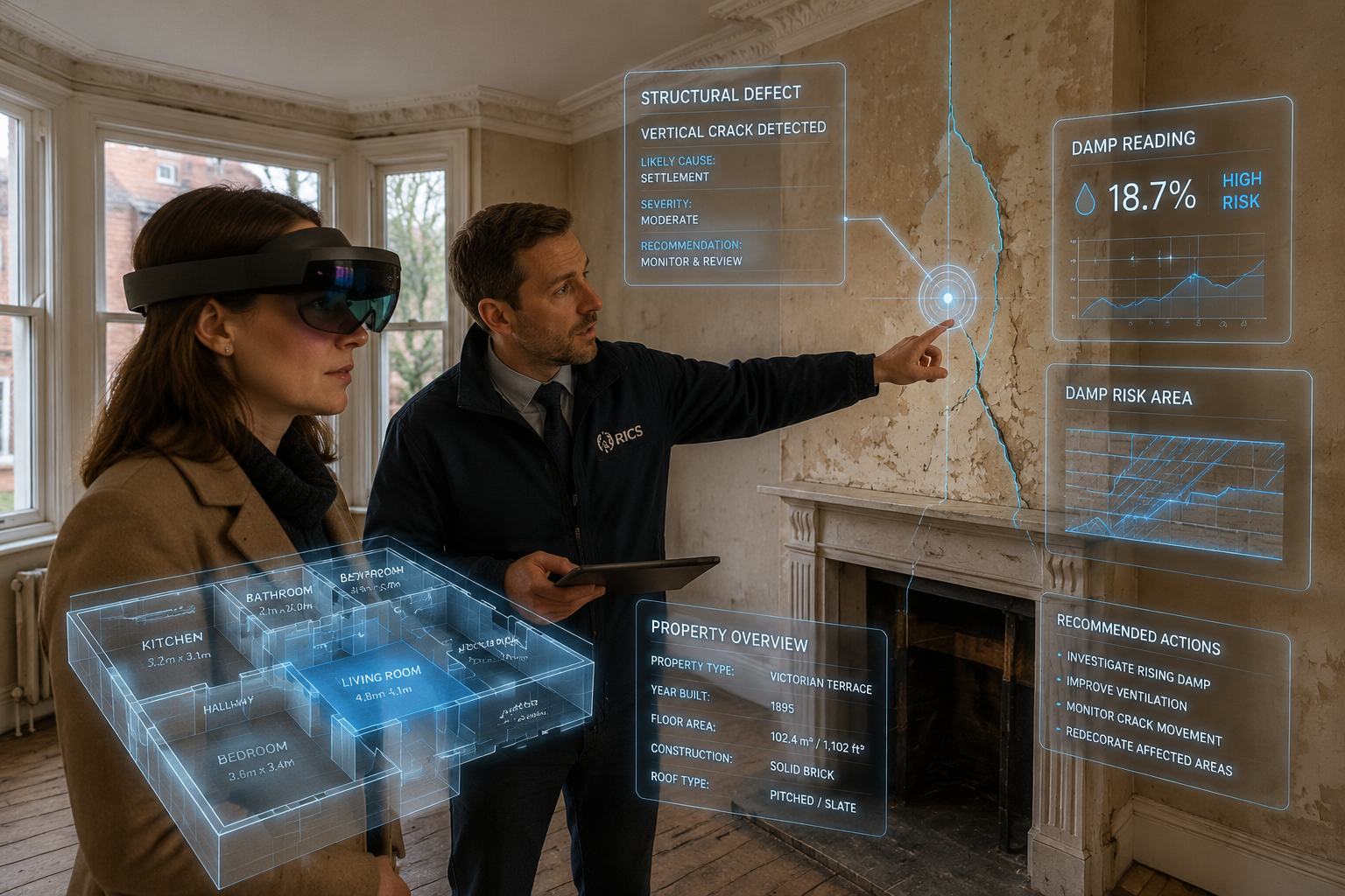
From Dense Reports to Visual Experiences
The traditional building survey report — 40 to 80 pages of technical prose — is not going away. But it is being supplemented by visual tools that make findings genuinely accessible to non-specialist clients [1][2].
Augmented reality (AR) walkthroughs allow clients to:
- View a property in 3D on a tablet or headset
- See defect annotations overlaid directly onto the relevant building element
- Understand the spatial relationship between problems (e.g., how a roof leak connects to damp in a first-floor wall)
- Prioritise repairs by severity in an interactive format
Tools like Matterport (for 3D virtual tours with annotation layers), HoloLens-based AR applications, and bespoke surveying platforms are all being adopted by forward-thinking UK firms [2][8].
Cloud-Based Reporting Platforms
Beyond AR, cloud reporting is changing how survey data is stored, shared, and updated. Benefits include:
- Real-time collaboration between surveyors, clients, and solicitors
- Automatic updates when new information is added post-inspection
- Searchable defect databases for portfolio management
- Audit trails that support expert witness work
For clients purchasing through chartered surveyors in London or other major UK cities, cloud platforms mean faster turnaround and clearer communication at every stage.
How AR Changes Negotiation Dynamics
One underappreciated benefit of visual survey outputs is their impact on property negotiations. When a buyer can show a vendor a drone photograph of cracked ridge tiles or an AR overlay highlighting rising damp, the conversation shifts from abstract risk to concrete evidence. This supports more confident, evidence-based price negotiations — a key driver of client satisfaction [1].
AI-Assisted Analysis: The Emerging Layer
Artificial intelligence is beginning to work alongside the hardware tools described above, adding an analytical layer that processes large data sets faster than any human team [5][6].
Current applications in UK building surveying include:
- Automated crack detection in point cloud and photographic data
- Pattern recognition for recurring defect types across portfolio surveys
- Predictive maintenance modelling — estimating when components will reach end of life
- Report drafting assistance — AI tools that convert inspection notes into structured report sections
⚠️ Important caveat: AI tools are assistants, not replacements. RICS guidance is clear that professional judgement and liability remain with the qualified surveyor [9]. AI outputs must always be reviewed and validated by a competent practitioner.
The RICS Future of Surveying report notes that the profession must develop digital literacy as a core competency alongside traditional technical skills [9]. Surveyors who understand how to interrogate AI outputs — and when to override them — will be better placed than those who either ignore the tools or trust them uncritically.
Practical Deployment Guide: Matching Technology to Survey Type
Understanding current trends in building surveying technology: from laser scanning and drones to AR walkthroughs for UK clients is one thing — knowing when to deploy each tool is another. Here is a practical framework:
🏠 Residential Surveys (Level 2 and Level 3)
- Drones: Recommended for all properties where roof access is limited or unsafe
- Thermal imaging: High value for older properties, suspected damp issues
- Laser scanning: Consider for complex layouts, extensions, or listed buildings
- AR/3D reporting: Increasingly expected by tech-savvy buyers; differentiates the service
For clients deciding between survey types, the survey comparison guide provides a clear breakdown of what each level covers and when advanced technology adds the most value.
🏢 Commercial Surveys
- Laser scanning: Near-essential for large or complex buildings
- Drones: Standard for external envelope inspections
- AI analysis: Valuable for portfolio-level defect trending
- Cloud reporting: Supports multi-stakeholder review processes
Surveyors working on schedules of dilapidations or schedule of condition reports benefit particularly from the precise, timestamped records that laser scanning and drone imagery provide — creating defensible evidence in lease-end disputes.
Costs, ROI, and Choosing the Right Tools
Technology Investment Overview
| Technology | Entry Cost | Ongoing Costs | ROI Driver |
|---|---|---|---|
| Laser scanner | £15,000–£50,000+ | Software licences | Faster measured surveys, fewer revisits |
| Survey-grade drone | £2,000–£8,000 | CAA compliance, maintenance | Roof/facade access without scaffolding |
| Thermal camera | £1,500–£10,000 | Calibration | Hidden defect detection |
| AR reporting platform | £200–£800/month | Subscription | Client retention, differentiation |
| AI analysis software | £100–£500/month | Subscription | Report speed, portfolio analytics |
For smaller firms, phased adoption is sensible. Starting with a drone and thermal camera delivers immediate practical value at modest cost. Laser scanning and AR platforms can follow as client demand and revenue grow.
Conclusion: Actionable Next Steps for UK Surveyors
Current trends in building surveying technology: from laser scanning and drones to AR walkthroughs for UK clients represent a genuine shift in what clients expect and what the profession can deliver. The technology is no longer experimental — it is practical, accessible, and increasingly expected [1][2][8].
Here are the key actions for UK surveyors in 2026:
- Audit your current toolkit. Identify which technology gaps are costing you time, accuracy, or client confidence.
- Start with drones and thermal imaging. These offer the fastest return on investment for most residential and commercial practices.
- Invest in digital literacy. RICS CPD pathways cover geospatial tools, BIM, and AI — prioritise these alongside traditional technical skills [9].
- Upgrade your reporting format. Even without full AR, adding annotated drone photographs and 3D floor plan sketches transforms client comprehension.
- Communicate the value clearly. Clients who understand why you use these tools are more likely to recommend your service and accept your fee.
- Stay compliant. CAA drone regulations, GDPR considerations for imagery, and RICS professional standards all apply — ensure your practice is up to date.
The surveyors who thrive in the next five years will not simply be those with the best equipment. They will be those who use technology to make complex information genuinely understandable — and who help clients make better decisions as a result.
References
[1] Current Trends In Building Surveying Whats Changing In 2026 – https://www.asg-consulting.co.uk/learning-and-resources/current-trends-in-building-surveying-whats-changing-in-2026
[2] How Technology Is Transforming Building Surveying – https://www.bressummerark.co.uk/insights/how-technology-is-transforming-building-surveying/
[3] The Future Of Measured Building Surveys Embracing Technology – https://www.michaelgallie.co.uk/the-future-of-measured-building-surveys-embracing-technology/
[5] The Future Of Building Surveying How Ai Is Transforming The Industry – https://mcessex.co.uk/2025/06/16/the-future-of-building-surveying-how-ai-is-transforming-the-industry/
[6] pbctoday.co.uk – https://www.pbctoday.co.uk/news/building-control-news/building-surveying-technology/89564/
[7] Modern Technology In Surveying – https://www.landtechsurveys.co.uk/post/modern-technology-in-surveying
[8] Six Technologies Quietly Transforming Construction Sites In 2026 – https://www.ube.ac.uk/whats-happening/articles/six-technologies-quietly-transforming-construction-sites-in-2026/
[9] Future Of Surveying – https://www.rics.org/news-insights/future-of-surveying